 South side of the Qaṣr el-Gibb | ||
| Qaṣr el-Gibb · قصر الجب | ||
| no tourist info on Wikidata: | ||
| ||

Qasr el-Gibb (also Qasr el-Gib, Qasr el-Geb, Arabic:قصر الجب, Qaṣr al-Ǧubb, „Well fortress") Or 'Ain el-Gibb (also Ain give, Arabic:عين الجب, ʿAyn al-Ǧubb, „Well source“) Is an archaeological site in the far north of the egyptian Sink el-Chārga in the Western desert. The tower-like fort from Roman times is located about 45 kilometers north of the city el-Chārga. The area should be of particular interest to archaeologists.
background
The fort is located approx. 4 kilometers west of the trunk road to Asyūṭ and about 2.5 kilometers north of es-Sumeira. There is no settlement in the vicinity of the fort, only a few shallow grave pits. Between Qaṣr el-Gibb and es-Sumeira, underground aqueducts (Arabic Qanat) laid out in three main lines, which extend from Qaṣr el-Gibb to es-Sumeira.[1]
The local fort was certainly a military outpost to the settlement of es-Sumeira. The area occupied by Qaṣr el-Gibb and es-Sumeira is 8.5 kilometers long and 3 kilometers wide. The fort's soldiers were certainly responsible for monitoring the desert route Darb ʿAin Amūr to the west of the fort, which is about Qaṣr el-Labacha led to ed-Dāchla and here in Qaṣr el-Gibb on the Darb el-Arbaʿīn met, and the monitoring of the Qanat system and its shafts.
The fort was part of a border fortification under the emperor Diocletian (Reigns 284-305) and his successors was created. The pottery found here confirms that the building was built in the 4th century AD. The decline of the military installation took place as early as the 5th century. In es-Sumeira there is another fort that is similar to the one here in terms of material and construction, so that both were probably built at the same time. In its shape, the fort is similar to that of one Burgus, a watchtower as it was used on the Germanic-Roman border at the same time. The fort was used again in Ottoman times.
Three kilometers north of Qaṣr el-Gibb there is a rock with rock carvings such as a boat, human figures and also Greek inscriptions.
The fort has only been mentioned or described by a few travelers, in 1874 by Georg Schweinfurth, the old tower ruin on the map Id el-Harb noted,[2] and in 1978 by Jean Gascou and Peter Grossmann. The archaeological site has been investigated since 2000 as part of the “North Kharga Oasis Survey” project headed by Salima Ikram and Corinna Rossi.
getting there
The site can be tackled with a motorcycle, a pickup or an all-terrain vehicle. About 20 kilometers north of el-Munīra one joins 1 25 ° 45 ′ 24 ″ N.30 ° 39 '52 "E from the trunk road to the northwest onto a dirt road that is partially silted up. The driver should be familiar with the area. After visiting Qaṣr el-Gibb, you can go to about 2.5 kilometers to the south es-Sumeira go on.
Tourist Attractions

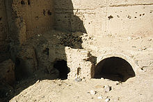
The 1 Qaṣr el-Gibb Castle(25 ° 49 ′ 31 ″ N.30 ° 36 '57 "E.) was built in an isolated location on a 16 meter high limestone cliff covered with basalt fragments. The fort was built from air-dried clay bricks and measures 16.5 by 15.5 meters. The walls, which are up to 11.5 meters high, are about 2.5 meters thick at the bottom and taper to about one meter at the top. The complex was once reinforced by round bastions at the corners. The only access is in the south. Immediately behind the entrance there is a staircase in the west (left). On the top of the wall there was a battlement, which is no longer accessible today. The east wall of the fort has broken away.

Inside there is a central courtyard that extends from north to south. On both sides of this courtyard there are three storeys with three rectangular rooms each. The rooms on the two lower floors have a barrel vaulted ceiling, the top floor once had a flat ceiling made of lightweight material. The rooms are set back towards the top so that they could be reached.
The rooms probably served as accommodation for soldiers. Assuming two floors and an occupancy of around 5 soldiers per room, Peter Grossmann calculated an occupancy of 60 soldiers.
kitchen
There are restaurants in town el-Chārga. There is also a bakery and café in el-Munīra.
accommodation
Accommodation is usually in the city el-Chārga elected.
trips
The visit of Qaṣr el-Gibb can be compared to that of es-Sumeira connect.
literature
- : Deux voyages archéologiques dans l’oasis de Khargeh. In:Bulletin de l’Institut français d’archéologie orientale (BIFAO), vol.79 (1979), Pp. 1-20, panels I-VI, in particular pp. 16-19, panels IV-VI.
- : Sites militaires romains de l’oasis de Kharga. In:Bulletin de l’Institut français d’archéologie orientale (BIFAO), vol.99 (1999), Pp. 377-396, in particular pp. 378, 385 f.
- : North Kharga Oasis Survey 2001-2002 Preliminary Report: Ain Gib and Qasr el-Sumayra. In:Communications from the German Archaeological Institute, Cairo Department (MDAIK), vol.60 (2004), Pp. 69-92, panels 8 f., In particular pp. 76-79.
Individual evidence
- ↑See also under es-Sumeira. : A Preliminary Survey of the Ancient Qanat Systems of the Northern Kharga Oasis. In:Communications from the German Archaeological Institute, Cairo Department (MDAIK), vol.59 (2003), Pp. 411-423.
- ↑Schweinfurth, Georg: Notes on the knowledge of the El-Chargeh oasis: I. Alterthümer, in: Communications from Justus Perthes ’geographical institute about important new researches in the entire field of geography by Dr. A. Petermann, Vol. 21 (1875), pp. 384-393, plate 19 (map).
Web links
- North Kharga Oasis Survey (NKOS)