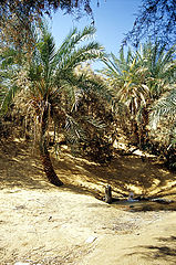
 Sand dunes in the south of Siwa | ||
| Western desert · الصحراء الغربية | ||
| no tourist info on Wikidata: | ||
| ||

The Western desert (engl. Western Desert, Arabic:الصحراء الغربية, aṣ-Ṣaḥrāʾ al-gharbīya, „the western desert“) Is in the west Egypt, west of the Nile Valley, and is the Egyptian part of the Libyan desert (engl. Libyan Desert, Arabic:الصحراء الليبية, aṣ-Ṣaḥrāʾ al-lībīya, „the Libyan desert"). Ultimately, it forms the easternmost part of the Sahara Desert. More and more tourists are discovering this travel destination, even if this desert does not have the touristic potential of e.g. Morocco. The highlights of the desert include the legacies of the former oasis inhabitants, mostly in the vicinity of today's oasis locations, the world-famous ones White desert and the longest shifting dune in the world at 1200 km Ghurd Abū Muḥarrik.
Oasis belt (sinks)

- Governorate el-Gīza
- 1 el-Baḥrīya


 in the Wikidata database") (el-Bāwīṭī, el-Ḥeiz)
(el-Bāwīṭī, el-Ḥeiz)
- 1 el-Baḥrīya


- Governorate New valley
- 3 el-Farāfra
- 4 ed-Dāchla (Courage)
- 5 el-Chārga
- 3 el-Farāfra


Other regions
- The 6 Wādī en-Naṭrūn (Sketis) is located on the eastern edge of the Western Desert, west of the highway from Cairo to Alexandria.

- The oasis 7 el-Faiyūm is located on the eastern edge of the Western Desert, southwest of Beni Suef. In the south of el-Faiyūm are the 8 Wādī er-Raiyān and the 1 Valley of the Whales.


- The Mediterranean coast forms the end of the Western Desert in the north.
places
- 1 el-Bāwīṭī in the valley el-Bahrīya.
- 2 el-Ḥeiz in the valley el-Bahrīya.
- 3 Siwa in the valley Siwa.
- 4 Courage in the valley ed-Dāchla.
- 5 el-Chārga in the valley el-Chārga.
- 6 el-Farāfra in the valley el-Farāfra.


Other goals


Most of the attractions are located in or near the oases of the above-mentioned depressions. Below you will find travel destinations that cannot be assigned to any of the sinks mentioned.
- 2 ʿAin Amūr is a Roman temple complex with a water source between ed-Dāchla and el-Chārga on the desert road between ed-Dāchla and Asyūṭ.

- 3 Deir el-Anbā amūʾīl, Monastery of St. Samuel in the governorate Beni Suef west of the Gebel el-Qalamūn.

- 4 el-Gara. The stalactite cave is about halfway between el-Farāfra and Asyūṭ.

- 5 El-Mughra is a small depression east of the Qaṭṭāra depression.
- 6 Qārat Umm eṣ-Ṣugheir (el-Gāra) is a valley and a castle hill oasis about 140 kilometers northeast of the city Siwa.

- 7 Wādī el-Ubeiyiḍ is a desert valley and a prehistoric archaeological site in the northwest of the El-Farāfra depression.

- 8 Djedefre water mountain is a limestone rock southwest of Mūṭ with prehistoric depictions of animals and text inscriptions from expeditions of the ancient Egyptian kings Cheops and its successor Djedefre (Radjedef).

Landscapes
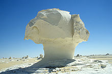
- The 9 white and 10 Black desert are desert regions in the area of the depression el-Baḥrīya and between el-Baḥrīya and el-Farāfra.


- The 11 Gilf Kebir in the southwest of the Western Desert is one of its outstanding scenic and archaeological regions. On the way from Mūt to the national park you can also get to 12 Samīr Lāmā rock and to the pitcher stations on 13 Abū-Ballā Weg-way. The Natianalpark also includes the 14 Gebel el-ʿUweināt, in which numerous rock carvings can be found.


- 15 Egyptian sand lake between the Gilf Kebir plateau and Siwa.

- Shifting dune 16 Ghurd Abū Muḥarrik in the east of the Western Desert.

- 17 Qaṭṭāra Depression - largest depression in Egypt. Travel destinations are mainly on the edges of the valley.

Caravan routes
- Darb Siwa - this 420 kilometer route connects the valley Siwa with the sink el-Baḥrīya. It passes the uninhabited depressions 18 el-ʿArag, 19 el-Baḥrein, 20 en-Nuweimisa and 21 Sitra.


- Darb Asyūṭ - this 280 kilometer route connects the valley el-Farāfra with the city Asyūṭ on the Nile.
- Darb eṭ-Ṭawīl - this 250 kilometer long red connects the valley ed-Dāchla with the city Asyūṭ.
- Darb el-Arbaʿīn - this 1,800-kilometer route connects the city Asyūṭ in Egypt With Kobbe in the district Darfur in the Sudan.
background


language
getting there
In the street
The inhabited depressions can be reached via two paved road rings.
In the north one arrives from Cairo/el-Gīza above Alexandria/el-ʿAlamein, Marsā Maṭrūḥ to Siwa and from Siwa on the trunk road between Siwa and el-Baḥrīya,طريق سيوة الواحات البحرية, Ṭarīq Sīwa al-Wāḥāt al-Baḥrīya to el-Baḥrīya or. el-Bāwīṭī. The last-mentioned street that the Darb Siwa follows, but can only be used with permission from the military. It is extremely difficult to get such permission. If you don't want to visit Alexandria, time can be saved by using the direct connection from Cairo to el-ʿAlamein. From Cairo to Siwa or el-Baḥrīya it is about 1,200 or 1,600 kilometers if you drive via Alexandria.
The distance from Cairo to Siwa can be covered by public buses.
In el-Baḥrīya one meets the second ring, so that one can either drive back to el-Gīza / Cairo or visit the other depressions.
The second ring, trunk road 10, also starts in Cairo/ el-Gīza and runs through el-Baḥrīya, el-Farāfra, ed-Dāchla, el-Chārga to Asyūṭ. The section el-Chārga to Asyūṭ roughly follows the northern part of the Darb el-Arbaʿīn. The entire ring can be covered with public buses.
In the case of the second ring, there are three more direct connections to the Nile valleybut which do not use public transport:
- The Bani Mazar El Baharia Road, طريق بني مزار البحرية, Ṭarīq Banī Mazār al-Baḥrīya, branches off the desert highway el-Gīza to Luxor and Aswan, the Cairo Luxor Desert Road, which runs on the west side of the Nile 1 28 ° 29 ′ 1 ″ N.30 ° 33 '42 "E West of Benī Mazār and crosses highway 10 between el-Manāgim and el-Ḥārra east of el-Bāwīṭī at 2 28 ° 25 ′ 3 ″ N.29 ° 8 ′ 33 ″ E. Coming from el-Baḥrīya, you can still see the archaeological sites of Tell el-āAmārna and Benī Ḥasan visit.
- The Dashlout El Farafra Road, طريق دشلوط الفرافرة, Ṭarīq Daschlūṭ al-Farāfra, branches off the desert highway el-Gīza to Luxor and Aswan 3 27 ° 34 '36 "N.30 ° 39 '37 "E in the east, west of Daschlūṭ or west of Deirūṭ, north of Asyūṭ, and flows into the city el-Farāfra at 4 27 ° 3 '37 "N.27 ° 58 ′ 12 ″ E onto trunk road 10.
- The Luxor Al Kharga Road, طريق الأقصر الخارجة, Ṭarīq al-Uqṣur al-Chārǧa, joins 5 25 ° 34 '54 "N.32 ° 27 '17 "E of the Aswan Western Agricultural Road on the western side of the Nile, southwest of Armant or southwest of Luxor and ends at 6 24 ° 48 '47 "N.30 ° 34 '51 "E. on the Baris Al Kharga Road (Darb el-Arbaʿīn) about 80 kilometers south of the city el-Chārga. There are no petrol stations or cafeterias on the way from Luxor to el-Chārga.
El-Faiyūm can be reached directly from Cairo / el-Gīza. Coming from el-Baḥrīya, one can go to 7 29 ° 45 ′ 58 ″ N.30 ° 30 '47 "E. on the Regional Ring Road, الطريق الدائري الإقليمي, aṭ-Ṭarīq ad-Dāʾirī al-Iqlīmī, branch off to the south and also arrives at el-Faiyūm.
By plane
The following flight connections can save you a considerable amount of time when traveling to the Western Desert:
- In the summer months, EgyptAir flies to Cairo twice a week, on Sundays and Thursdays Marsā Maṭrūḥ. From here it is about 300 kilometers to Siwa, which you can cover with regular buses or minibuses. Otherwise, the bus journey from Cairo to Siwa takes about ten hours.
- Twice a week, on Sundays and Thursdays, flies Petroleum Air Services from Cairo to el-Chārga. The plane tickets can only be bought in Egypt. The bus journey from Cairo to el-Chārga also takes about ten hours.
mobility
For trips into the desert you either need a motorcycle or an all-terrain four-wheel drive vehicle. In addition, the (paid) approval by the Egyptian military is mandatory. Day tours in the immediate vicinity of the oasis locations and in the are subject to authorization white and Black desert except.
Tourist Attractions
activities
Desert safaris
Motorcycle tourism
It is entirely possible to cross the Western Desert on a motorcycle, a suitably equipped one motorcycle and driving skills required. Since it is not very easy to enter Egypt with a vehicle, the following motorcycle tourism companies are named for those interested who also provide the motorcycles:
- Franco Picco Racing Team (Franco Picco Adventures), P.F.R. s.r.l. Via dei Muzzi 59, 36050 Sovizzo Vicenca, Italy. Tel.: 39 0444 379.017, 39 0444 357.936, Mobile: 39 339 5371664, Fax: 39 0444 379.010, Email: [email protected].
Of course, the drivers are accompanied by jeeps that also transport the material.
kitchen
accommodation
There are several in the main locations of the individual depressions Hotelswhich are mostly simple. To a lesser extent there are three- and four-star hotels. A special form of hotels are so-called. Ecolodges, these are hotels that are built and operated according to ecological standards. Traditional materials and craft techniques are used for construction. These Ecolodges are always away from the cities in an attractive landscape, e.g. in Siwa and ed-Dāchla, and offer various opportunities for recreation. Unfortunately, these hotels are very expensive.
For excursions in the desert, usually in Camping spent the night. The sky even offers millions of stars.
security
climate
The climate is warm to hot and dry all year round. Rainfalls are an absolute exception, the rain duration never exceeds a few minutes.
Climate in ed-Dāchla
| Dāchla | Jan | Feb | March | Apr | May | Jun | Jul | Aug | Sep | Oct | Nov | Dec | ||
|---|---|---|---|---|---|---|---|---|---|---|---|---|---|---|
| Mean highest air temperature in ° C | 22 | 24 | 28 | 34 | 37 | 39 | 39 | 38 | 36 | 33 | 27 | 23 | O | 31.7 |
| Average air temperature in ° C | 12 | 14 | 18 | 24 | 28 | 31 | 31 | 30 | 28 | 24 | 18 | 14 | O | 22.7 |
| Mean lowest air temperature in ° C | 4 | 5 | 9 | 13 | 18 | 22 | 22 | 22 | 20 | 16 | 10 | 5 | O | 13.8 |
| Precipitation in mm | 0 | 0 | 0 | 0 | 0 | 0 | 0 | 0 | 0 | 0 | 0 | 0 | Σ | 0 |
Dakhla, Egypt: Climate, Global Warming, and Daylight Charts and Data, accessed November 17, 2009. | ||||||||||||||
Climate on the Mediterranean coast
| Alexandria | Jan | Feb | March | Apr | May | Jun | Jul | Aug | Sep | Oct | Nov | Dec | ||
|---|---|---|---|---|---|---|---|---|---|---|---|---|---|---|
| Mean highest air temperature in ° C | 18 | 19 | 21 | 24 | 26 | 29 | 30 | 30 | 30 | 28 | 24 | 20 | O | 24.9 |
| Mean lowest air temperature in ° C | 9 | 9 | 11 | 13 | 17 | 20 | 23 | 23 | 21 | 18 | 14 | 11 | O | 15.8 |
| Precipitation in mm | 53 | 29 | 14 | 4 | 1 | 0 | 0 | 0 | 1 | 9 | 32 | 53 | Σ | 196 |
| Rainy days in the month | 11 | 9 | 6 | 2 | 1 | 0 | 0 | 0 | 0.2 | 3 | 5 | 10 | Σ | 47.2 |
The sandstorms are feared Chamsīn (Arabic:خماسين, Chamāsīn, orخمسين, Chamsīn) to be named. These are hot south and south-east winds that stir up the desert sand and carry it away with them. The causes are low pressure areas in the Mediterranean area. The storms can occur all year round, their main season is the months of March to May (a period of 50 days after the beginning of spring - the Arabic word also refers to this period), and they also occur more frequently in autumn. The storms last for several days and are in large parts Egypt to be found. Far more dangerous, but more localized, are the sand whirlwinds, called soba'a. Here you have to protect your eyes and electronic devices in any case. The storms often contribute to flight plans no longer being adhered to. In 2006, the first sandstorm occurred in late February (locals said they hadn't seen it in 20 years), and somewhere in the dust, even the pyramids were barely visible.
literature
- Popular scientific presentations:
- : The Egyptian oases: cities, temples and tombs in the Libyan desert. Mainz: from Zabern, 2003, Zabern's illustrated books on archeology, ISBN 978-3-8053-2915-6 .
- : The Western Desert of Egypt: an explorer’s handbook. Cairo: The American University at Cairo Press, 2008, ISBN 978-977-416-090-5 (in English).
- cards
- Map of the Western Desert Oases of Egypt. Cairo: American University in Cairo Press, Geodia Edizioni, 2009 (2nd edition), ISBN 978-88-87177-76-3 . Erasable, tourist map, main map 1: 1,900,000 with detailed maps of the depressions and regions.
Further literature is given in the individual articles.
