 Castle hill of Qārat Umm eṣ-Ṣugheir | ||
| Qārat Umm eṣ-Ṣugheir قارة أم الصغير | ||
| Governorate | Maṭrūḥ | |
|---|---|---|
| Residents | 363 (2006) | |
| height | −45 m | |
| no tourist info on Wikidata: | ||
| location | ||
| ||

Qarat Umm es-Sugheir (also Qaret Umm al-Sughayyar, Arabic:قارة أم الصغير, Qārat Umm aṣ-Ṣughair / aṣ-Ṣaghīr, „Hill of Umm / mother aṣ-Ṣughair") Or short el-Gāra / Qāra (القارة, al-Qara, „the hill", also al-Jara spoken) or Wāḥat el-Qāra is a egyptian Oasis about 140 kilometers northeast of the city Siwa on the northwest inner edge of the Qattara Depression. Despite the great distance, the oasis and the hamlet of the same name are administratively part of the district (مركز, Markaz) Siwa.
The main attraction is the now uninhabited castle hill, the castle hill Shali in the city Siwa or. Aghūrmī resembles.
background
location
The Qārat Umm eṣ-Ṣugheir oasis is located on the north-western inner edge of the Qaṭṭāra Depression. The terrain here drops steeply to a plateau about 20 to 25 kilometers wide, before the plateau itself drops into the actual Qaṭṭāra depression. The oasis is located in a shallow depression on the said plateau.
History and population

The old village that is the castle hill Aghūrmī or Shali resembles, is evidently already inhabited before the turn of the century. The geographer Claudius Ptolemy (83–168 AD) refers to this place on one of his maps as "Camp of Alexander [the great]", probably because this oasis was on the way of Alexander the great to Memphis.
Even if the village is counted as part of Siwa, the local residents belong to a different race. The people are a bit darker-skinned. Marriages are only concluded between locals. The residents speak the Berber dialect Sīwī.
The castle hill is uninhabited today. At the beginning of the 20th century, the first buildings were erected below the rock. The population has never been large, 142 people lived here in 1966, today it is about 370 people.[1] Part of the population moved there in the 1960s ez-timeunto escape their poor conditions.
The number of inhabitants in the village has been fairly constant since 1950. There is a superstition that if a child is born early in the morning, another villager will die in the evening of the same day.
The head of the village has been Sheikh Ḥasan since 1993 and died in 2009. Sheikh Mahdī has been the head since then.
The main line of business is the cultivation of date palms. Today the village is also the starting point for oil exploration and production.
Research history
The Briton was one of the first Europeans to visit this village William George Browne (1768-1813). Of Alexandria coming he followed suit on March 7, 1792 before continuing his journey Siwa Rest. He reported:[2]
- “On Wednesday, March 7th, 1792, during the night we reached a small village called قارة ام الصغير Karet-am-el Sogheir. It's a poor place, the buildings are mostly clay, and the residents are noticeably poor and dirty. They [the residents] offered the seasonal care with fresh water, some mutton (for this the Sheikh el Ballad [village chief] was kind enough to kill a sheep in exchange for some insignificant gifts that were given him) and wood for that To prepare pilau [a rice dish], which we have had to do without since leaving the coast. This village is independent and its surroundings offer nothing but dates, where even the camels and donkeys of this area are used to finding their food.
- About a mile and a half from Karet-am-el Sogheir there are date palms scattered across the country and some water to be found. Then it becomes a perfect desert again, consisting of the same mountains of sand and bare rock, as explained above, for the period of the approximately five-hour journey. "
In 1976 the German ethnologists Lothar Stein and Walter Rusch visited the oasis, in 1979 and 1981 the German ethnologist Frank Bliss.
getting there
You need a permit from the military, which must be obtained at least one day in advance (see also under Siwa (city)). The tourist information office in Siwa can help. The permit costs LE 148 (as of 9/2014).
There are two ways of getting here.
The first option leads directly from the city Siwa to Qārat Umm eṣ-Ṣugheir, takes about 3 hours and leads mostly over a desolate plateau. The piste is clearly recognizable by the tracks, and an old barrel occasionally lines the way.
You leave the city Siwa in a northerly direction to Marsā Maṭrūḥ and branches off at the point 1 29 ° 15 '56 "N.25 ° 31 '26 "E to the east. At the point 2 29 ° 16 ′ 7 ″ N.25 ° 38 ′ 31 ″ E one branches off to the left into the desert (the other way leads to Abū Schurūf).
Shortly after the start of the journey, you get to 1 Umm Huweiml(29 ° 20 '34 "N.25 ° 52 '46 "E), أم هويمل, Also Umm el-Huyūs,أم الهيوس, Called. Here is an unused irrigation project of the Egyptian government to develop new land. At the end you reach the village from the south.
The second option exists since the 2010s on an asphalt road. The Siwa – Marsā Maṭrūḥ trunk road has south of the Amo cafeteria in the area of the Biʾr en-Naṣṣ bei petrol station 3 30 ° 15 '44 "N.26 ° 15 ′ 21 ″ E a branch to the east on an asphalt road to Qārat Umm eṣ-Ṣugheir, whereby the settlement can be reached from the north.
Tourist Attractions
If you use the first mentioned travel option, you will get to one first 2 artificial spring pond(29 ° 35 '56 "N.26 ° 29 ′ 29 ″ E).

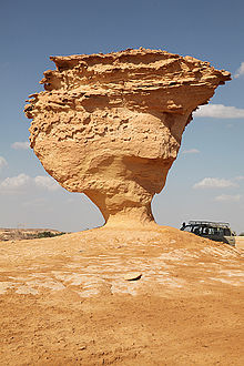
The main attraction is of course the fortified one 3 old residential town(29 ° 37 ′ 18 ″ N.26 ° 29 ′ 50 ″ E) on a 10 m high limestone cliff in the south of the modern settlement. In ancient times, a gate made of palm trunks secured access. Nowadays a modern staircase leads straight up. At the end of the stairs there is a small viewing platform where you can linger for a while. The houses are around the central square (سوق البلد, Sūq al-Balad) grouped. The houses built from salt clay are two-story and have only small windows. There are no signs of window frames or shutters. The blankets consist of palm trunks with wickerwork. The basement was intended for the livestock.


The houses are separated by narrow streets. Houses, the fountain (بئر الفوقي, Biʾr al-Fauqī, „the upper well“), Which only supplied brackish water, and the streets are labeled, but only in Arabic.
A building that could have been used as a mosque is located near the observation tower, which can also be climbed. From above you have an excellent view of the entire area.
To the northeast is the 4 modern hamlet(29 ° 37 ′ 27 ″ N.26 ° 29 ′ 56 "E).


West of the castle hill is located 5 Sheikh Yāgā's tomb(29 ° 37 '17 "N.26 ° 29 '48 "E.), مقام الشيخ ياجا, Maqām al-Sheikh Yāǧawhich is located in a simple, whitewashed building. The grave is still being tended. A chain with ostrich eggs hangs above the grave, which is covered with a green cloth. There are wicker baskets on a chest next to the grave.


The rock is about 1 kilometer southwest 6 el-Qaṭṭāra(29 ° 37 ′ 5 ″ N.26 ° 29 ′ 19 ″ E), القطارة, al-Qaṭṭāra, „the dropper bottle“, With the source of the same name ʿAin el-Qaṭṭāra. In a small cave at the foot of the mountain, drops of water fall from the cave ceiling. Reeds and some flowers grow near the cave.

In the walls of the rocks you can see several burial chambers, all of which are undecorated and did not contain any grave goods.
Other sources include 7 ʿAin Wāḥil, عين واحل, And 8 ʿAin Shiṭār, عين شطار, In the east of the village or 9 ʿAyn el-Hashab, عين الخشب, In the southwest of the village.
activities
It is not very common for guests or foreigners to come here. So the chief Sheikh Mahdi insists on inviting the guests to tea, dates and nuts. You should take this time. During the conversation you can also leaf through the guest book.
kitchen
Food must be taken with you.
accommodation
There are no accommodations.
Practical advice
Many of the modern blessings have not yet arrived in this village. There is no telephone and no cell phone reception.
literature
- : Siwa Oasis. Cairo: The American Univ. in Cairo Pr., 1973, The oases of Egypt; 1, ISBN 978-977-424-123-9 (Reprint), p. 135.
- : The Siwa oasis: among the Berbers and Bedouins of the Libyan desert. Leipzig: F. A. Brockhaus, 1978, Pp. 137-143.
- : Siwa - the oasis of the sun god: Living in an Egyptian oasis from the Middle Ages to the present day. Bonn: Political Working Group Schools (PAS), 1998, Contributions to cultural studies; 18th, ISBN 978-3-921876-21-3 (Pb), ISBN 978-3-921876-22-0 (Linen), p. 37 f.
Individual evidence
- ↑Population according to the 2006 Egyptian census, accessed June 3, 2014.
- ↑: Travels in Africa, Egypt, and Syria, from the year 1792 to 1798. London: Candell and Davies, Longman and Rees, 1799, P. 17.
