 Landscape in the north of Bir el-Gebel | ||
| ed-Dāchla · الواحات الداخلة | ||
| Governorate | New valley | |
|---|---|---|
| length | 70 km | |
| height | from 108 m | |
| Residents | 80.209 (2006)[1] | |
| location | ||
| ||

The sink ed-Dachla (also el-Dachla, el-Dakhla, Roof, Arabic:الواحات الداخلة, al-Wāḥāt ad-Dāch (i) la, „the inner oases“) Lies in the central part of the Western desert in the egyptian Governorate New valley (closely. New Valley). Together with the sink el-Chārga it formed the "Great Oasis" of antiquity. The main town of the valley is the city Courage. On foot, by camel or jeep you can explore prehistoric, ancient Egyptian and medieval monuments, oasis landscapes and the desert on the edge of the valley.
Regions
The depression is divided into two parts: the larger settlement area with the cities courage and Qasr ed-Dachla is in the west. The villages are located in the eastern settlement area Balat and Tineida.
places

- 1 Courage is the main town and the administrative center of the valley. There are some inexpensive hotels in the city, and due to its central location, it is an ideal starting point for excursions both in the surrounding area and in the entire valley itself. Sights include that
 ethnographic museum, the Old town of Mūṭ and the archaeological site Mūṭ el-Charāb.
 - 2 Balāṭ is the largest village in the eastern settlement area. The old village center of Balāṭ is one of the few still inhabited in the valley. In the vicinity of the settlement are the archaeological sites of Qilāʿ eḍ-Ḍabba and ʿAin Aṣīl.


Other goals
North of Mūṭ
The following places are located in the area of the trunk road to el-Farāfra. In the area of the village 1 el-Gīza (Arabic:الجيزة) The trunk road branches off to the west. The sites north of Mūṭ and west of ed-Duhūs can be reached together on a circuit.
- Mūṭ Talata or Bir Talata is the name of well No. 3 (3 kilometers from Mūṭ, 2 25 ° 30 '53 "N.28 ° 57 ′ 44 ″ E) on the western side of the street. A hostel was built at the source. For a small fee (approx. LE 10), guests can also use the hostel’s 43 ° C pool.
- The 3 artificial lake(25 ° 31 '51 "N.28 ° 57 ′ 2 ″ E) for fish rearing (6 kilometers from Mūṭ was laid out with German help and is located about 2 kilometers north of the Mut-3-Hotel and 6 kilometers north of Mūṭ on the western side of the road. The water of the lake is heavily polluted, however, it is allowed are not fished and it is not suitable for swimming.
- 4 ed-Duhūs(25 ° 33 '17 "N.28 ° 56 ′ 55 ″ E), 8 kilometers from Mūṭ, too el-Duhus, el-Dohous, Arabic:الدهوس, ad-Duhūs, is a very small village on the east side of the road. But it is famous for that located in the northeast of the village 1 Bedouin Village Camp(25 ° 33 '45 "N.28 ° 57 ′ 0 ″ E). In the area of the village another road turns to the west, the villages and sights of which are described in the following section.
- 5 Deir Abū Mattā (19 kilometers from Mūṭ) is an ancient monastery in the south of Budchulū, the remains of the basilica are on the western side of the road.
- The village 6 Budchulū (21 kilometers from Mūṭ) is on the east side of the road. The old village center, which is unfortunately very dilapidated, is medieval. The old mosque and its minaret as well as the cemetery from Turkish times are worth seeing.
- 7 Biʾr el-Gebel (34 kilometers from Mūṭ) is a spring in the north of the village of el-Gīza (29 kilometers from Mūṭ). North of this village 1 branches(25 ° 42 ′ 0 ″ N.28 ° 54 '42 "E) take a road that will take you to the source after about 5 kilometers.
- 8 Qaṣr ed-Dāchla (short Qaṣr, 33 kilometers from Mūṭ) is the largest village in the western part of the valley. North of the village is one of the most important sights of the valley with the medieval fortified old town.
- 9 Naqb el-Qaṣr (37 kilometers from Mūṭ) is the only pass through the northern mountains, the Daffa Plateau, in the north of the valley. On the Darb el-Farāfra one reaches the depression el-Farafra.
- The graves of 10 Qārat el-Muzawwaqa (39 kilometers from Mūṭ) were created in Greco-Roman times. The tombs of Petubastis and Petosiris with their colorful representations have been open to visitors since the end of October 2013.
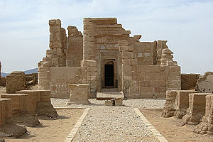
- 11 Deir el-Ḥagar (43 kilometers from Mūṭ) is the location of a temple for the Theban triad Amun-Re, Mut and Chons. It is the best preserved pharaonic temple complex in the valley.
- 12 el-Mauhub(25 ° 41 ′ 16 ″ N.28 ° 48 ′ 21 ″ E), 42 kilometers from Mūṭ, too el-Mawhub, Arabic:الموهوب, Is the westernmost village of the valley and is located south of the trunk road.
- The 13 Gebel Edmonstone(25 ° 40 ′ 1 ″ N.28 ° 42 ′ 9 ″ E), 54 kilometers from Mūṭ, is a striking elevation in the west of Deir el-Ḥagar with a diameter of 11 kilometers.


West of ed-Duhūs


West of ed-Duhūs 2 branches(25 ° 33 '16 "N.28 ° 56 ′ 50 ″ E) an asphalt road that connects other villages in the northwest of the valley. It joins the main road to el-Farāfra in front of the western entrance to the village of Qaṣr ed-Dāchla 3 25 ° 41 ′ 37 ″ N.28 ° 52 ′ 42 "E. Halfway to el-Qalamūn, slopes branch off to two springs.
- 14 Biʾr el-Qalamūn(25 ° 33 '24 "N.28 ° 56 ′ 13 ″ E), Arabic:بئر القلمون, About 2 kilometers from ed-Duhūs, is an artificial spring near ed-Duhūs. The first 4 Branch(25 ° 33 '8 "N.28 ° 56 ′ 9 ″ E) to the north on the road to el-Qalamūn leads to this source.
- 15 Magical source (2.5 kilometers from ed-Duhūs). A little further west leads in 5 Branch(25 ° 33 '7 "N.28 ° 55 ′ 56 ″ E) to the south to the so-called Magical Spring. Even if the magic arose more from the wishes of the tourist industry, everything is available for a small bathroom.
- 16 el-Qalamun (4 kilometers from ed-Duhūs) is a village with an old village center that is worth seeing, but unfortunately it is also falling into disrepair.
- 17 el-Gadida(25 ° 34 '34 "N.28 ° 51 ′ 35 ″ E), 11.5 kilometers from ed-Duhūs. El-Gadīda, Arabic:الجديدة, al-Hadida, the "new village", was founded around 1700 and also mentioned by Archibald Edmonstone (1819). Frank Bliss reported that the oldest evidence is a lintel beam from the mid-18th century. Around the same time, the village was populated by four clans: the el-Chudūra from Cairo, the Bakakra, the el-Fedān and the Gharghūr. Holy feasts (mulids) are celebrated at the graves of the ancestors to this day. From here other hamlets were settled: esch-Sheikh Wālī, el-Maʿṣara and el-Gharghūr. The village was of considerable size, as an elaborate mill could be operated here.[2] In 1983 there were 4,359 inhabitants in the village[3] and in 2006 3,778[1]. In the village there is a manufacture for furniture and window grilles.
- 18 el-Mūschīya(25 ° 36 '49 "N.28 ° 52 ′ 7 ″ E), 15 kilometers from ed-Duhūs, too el-Mushiya, Arabic:الموشية, al-Mūschīya) is a village north of el-Gadīda with 2,580 inhabitants (2006)[1].
- 19 Amḥeida (22 kilometers from ed-Duhūs) is an important Roman settlement. The Villa des Serenus is one of the most important finds. The site is to be made accessible to visitors in the future. A replica of the villa is being built. The journey via el-Qaṣr is 7 kilometers longer.
- In the south of Amḥeida, on the western side of the road, is 20 Tomb of Sheikh eḍ-Ḍahāwī(25 ° 39 ′ 15 ″ N.28 ° 52 '24 "E).


East of the trunk road to el-Farāfra
On the right-hand side of the trunk road to el-Farāfra one begins in Mūṭ on Taḥrīr Square 6 road(25 ° 29 '43 "N.28 ° 58 ′ 47 ″ E)which connects the places in the northeast of Mūṭ. It meets 600 meters southeast of ed-Duhūs 7 25 ° 33 ′ 1 ″ N.28 ° 57 ′ 2 ″ E onto the trunk road to el-Farāfra.
- 21 el-Hindāu(25 ° 32 '43 "N.28 ° 59 ′ 41 ″ E), 6 kilometers from Mūṭ, too el-Hindaw, Arabic:الهنداو, al-Hindāu, is a village with 3,681 inhabitants (2006).[1] Although the place is one of the oldest in the valley, there are no ancient sites in its vicinity.
- About 700 meters west of the village 22 el-ʿUweina(25 ° 33 '27 "N.28 ° 58 ′ 29 ″ E), 8.5 kilometers from Mūṭ, Arabic:العوينة, al-ʿUwaina, is the common 23 El-Hindāu and el-ʿUweina cemeteries(25 ° 33 ′ 40 ″ N.28 ° 58 ′ 9 ″ E).
In the area of ed-Duhūs branches at 8 25 ° 33 '16 "N.28 ° 56 ′ 50 ″ E also a road to the northeast. It leads through er-Rashda and returns 9 25 ° 34 '30 "N.28 ° 55 ′ 54 ″ E back on the trunk road 1.5 kilometers northeast of ed-Duhūs.
- 24 er-Rāschda / er-Rāschida(25 ° 34 '59 "N.28 ° 56 ′ 26 ″ E), 12 kilometers from Mūṭ, too el-Rashda, Arabic:الراشدة, ar-Rāschda / ar-Rāschida, is a village with 5,247 inhabitants (1983)[1] north of el-Hindāu. Gerhard Rohlfs stated that it was a relatively young place, but that Edmonstone had already mentioned, and that there were 1,000 inhabitants and 8,000 palm trees in the village.[4] At the beginning of the 20th century the place was quite wealthy.
West of Mūṭ
- 25 Biʾr esch-shaghāla refers to a hill immediately west of Mūṭ, on which a Roman cemetery was created. This site is to be made accessible to tourists in the future.

East of Mūṭ
The following places are still in the western settlement area in the area of the trunk road to el-Chārga:

- The 26 Dig house of the Dakhleh Oasis Project(25 ° 30 '23 "N.29 ° 0 ′ 35 ″ E) is located on the southern side of the road (3.5 kilometers from Mūṭ on the Gebel el-Gindī (Arabic:جبل الجندي, „Soldier's Hill“).
- 27 esch-Sheikh Wālī(25 ° 30 '56 "N.29 ° 1 '6 "E), 5 kilometers from Mūṭ, Arabic:الشيخ والي, Is a village on the north side of the trunk road with 2,388 inhabitants (2006)[1], in which there is also a hotel (see below).
- 28 Deir el-Malāk (8 kilometers from Mūṭ) is a church ruin from the 16./17. Century north of the trunk road.
- 29 el-Maʿṣara (8.5 kilometers from Mūṭ) is a village on the south side of the trunk road. About five kilometers southeast of the village on the edge of the desert is the Roman cemetery of 30 Beit el-ʿArāʾis.
- 31 Ismant (10.5 kilometers from Mūṭ) is a village on the north side of the trunk road. 3 kilometers northwest of this village is the early Christian archaeological site 32 ʿAin el-Gadīda. This is what happens on the way there 33 Tomb of the Sheikh ʿAbūda.
- 34 Ismant el-Charab, the ancient Kellis, (14 kilometers from Mūṭ) is a ruin site southeast of the name-giving village Ismant, south of the trunk road. Here was an ancient Roman settlement between the 1st and 5th centuries AD with two temples, large family graves and three churches. 2 kilometers southwest of Kellis is located with 35 ʿAin Sabīl another early Christian archaeological site.
- 36 esch-Sheikh Muftāḥ(25 ° 30 ′ 6 ″ N.29 ° 7 ′ 0 ″ E), 18 kilometers from Mūṭ, Arabic:الشيخ مفتاح, Is a village 3 kilometers south of the trunk road.


Eastern part of the valley

- Balāṭ (32 kilometers from Mūṭ) is the largest village in the east. The old, inhabited village center south of the trunk road is worth a visit.
- In 37 Qilāʿ eḍ-Ḍabba (34 kilometers from Mūṭ) is the cemetery of the ancient settlement ʿAin Aṣīl. Here are five mastaba graves from the 6th dynasty from the end of the Old Kingdom. The most important tomb is the mastaba of Chentika.
- 38 ʿAin Aṣīl (35 kilometers from Mūṭ) is the location of a settlement that was created in the 6th Dynasty as the seat of the local oasis governors and was used until the New Kingdom.
- 39 el-Bashandī (43 kilometers from Mūṭ) is a village with several Roman graves in the north. The most important grave is that of the Kitines. The village is about 3 kilometers north of the trunk road.
- 40 Ḥalfat el-Biʾr (40 kilometers from Mūṭ) is the name of a rock group with drawings that were created between prehistory and the Greco-Coptic period. The drawings come from people passing through who were on the Darb eṭ-Ṭawīl from or to Asyūṭ were on the way.
- In 41 ʿAin Birbīya (40 kilometers from Mūṭ) there is a temple complex that was dedicated to the god Amun Night. Even after the scientific excavation, the temple remains buried in the sand because of the fragile sandstone.
- 42 Tineida (43 kilometers from Mūṭ) is the easternmost village of the valley. In the southeast of the village is his cemetery with unusual tombstones. Far to the south of the village are (or were) ancient rock carvings along the caravan route Darb el-Ghubbari and the 43 Camel rocks.
- 44 el-Qaṣaba (41 kilometers from Mūṭ) is a now uninhabited historical village in the southwest of the partial depression, about 9 kilometers south of Balāṭ.


background
Naming
Ed-Dāchla is mostly associated with the depression about 190 kilometers to the east el-Chārga as "Double oasis" summarized. In ancient Egyptian times this was called a double sink wḥA.t or wḥA.t rsy.t (the oasis or the southern oasis), but also knm.t (southern oasis). In Greco-Roman times this administrative unit was called Oasis magna or Oasis megale (Greek ῎Οασις μεγάλη), i.e. "the great oasis". The administrative separation takes place around the 4th century AD, it now bears its current name, the "inner oases".
location
The Lower ed-Dāchla is located 120 kilometers east of el-Chārga. It ranges from 28 ° 48 'E to 29 ° 21' E (west - east) with an average latitude of approximately 70 kilometers and from 25 ° 44 'N to 25 ° 28' N (north - south) with a longitude of approx. 20 kilometers. This means that the depression is roughly at the same latitude as Luxor. The depression is shaped like an arc that extends from northwest to southeast. The depression divides into two partial depressions, which are separated by a strip of desert about 20 kilometers wide. In the west is the larger part with the localities Qaṣr ed-Dāchla, Courage and Ismant, in the east the smaller one with the localities Balāṭ and Tineida.
From ancient times you could see the valley on different levels Caravan routes to reach. It is the only route that is 250 kilometers long ed-Darb eṭ-Ṭawīl (Arabic:الدرب الطويل, „the long route“) A direct connection to the Nile Valley to Banī ʿAdī in the northwest of Asyūṭ. This route took about four to six days with camels. It begins in Balāṭ or Tineida. There are no water points on the way. 40 kilometers north of the Balāṭ Pass can be reached via the von Qaṣr ed-Dāchla coming Darb el-Chaschabi (Arabic:درب الخشبي) Also this route.
The sink el-Chārga can be reached in two ways. On the one hand, this is the 140 kilometers long Darb el-Ghubbari (Arabic:درب الغباري), Which begins in Tineida and largely follows the modern trunk road in the south of the mountain range. Prehistoric, Roman, Coptic and Arabic graffiti testify to its popularity. However, water had to be carried as there are no water points here either. The more northerly route, the Darb ʿAin Amūr (Arabic:درب عين أمور), Leads over the limestone plateau and is about 130 kilometers long. The route is a little more difficult because it requires an ascent and descent. There are water points for this. Halfway there is the fountain of ʿAin Amūr. Further sources follow in ʿAin Umm ed-Dabādīb and Qaṣr el-Labacha.
Even in the valley el-Farafra lead two routes. On the one hand, this is the 200 kilometers long Darb el-Farāfra (Arabic:درب الفرافرة), Which begins in el-Qaṣr and over the Farāfra Pass and Biʾr Dikkār leads. This route took about four days. The significantly longer one at 310 kilometers Darb Abū Minqār (Arabic:درب أبو منقار) Follows the modern road to el-Farāfra Abū Minqār.
It is disputed whether and in what form a route ed-Dāchla – ʿUweināt – el-Kufra existed. The archaeologically documented Abū Ballāṣ route could have been part of this route.
landscape

Large parts of the depression are now desert without vegetation. Artesian groundwater is available in the deepest places, which allowed a constant presence of humans. About half of the area is cultivated.
The deepest points are at a height of about 108 meters in Courage and 128 feet in el-Qaṣaba. At the edges in the north and east, the limestone plateaus rise to a height of 420-560 meters. The limestone formation contains fossils and rests on a sandstone formation. In the northwest there is the largest single elevation, the Edmonstone Gebel. The name comes from members of the Rohlfs expedition in 1874 in memory of the British Archibald Edmonstone (1795–1871), who was the first European to travel to the valley.
In prehistoric times there were Playa lakes in the south of the valley, which were created from rainwater. To the south, the terrain rises gradually and ends in a sandstone plateau, which is, however, not exactly delimited.
In particular, the northern part of today's landscape was created by erosion. The softer sandstone was removed. So stayed in some places like in the area of Biʾr el-Gebel so-called. Yardangs (Wind humps) that the wind has formed from the harder material.
Flora and fauna
The flora is mainly characterized by useful plants such as date palms, apricot, lemon, orange, mango and olive trees and by the cultivation of cereals (wheat, millet and barley). Nevertheless, the variety of plant species to be found here is quite high. During the stay of the Rohlfs expedition in 1874, 190 wild plant species were counted.[5]
history
Prehistory and the Früdynastic Period
The valley ed-Dāchla was already in Pleistocene populated.[6]
Cross-sectional excavations at various points in the north of the depression have provided evidence of different cultures living here. The appearance differed considerably from today's. At that time there was a lush savannah with a rich population of trees and animals such as gazelles, zebras, buffalo, hyenas, ostriches, giraffes and elephants. Hippos, fish and water birds lived in and around the Playa lakes created by rainwater. The Acheuleans, consisting of homo erectus (Paleolithic culture [Palaeolithic], approx. 1.5 million - 150,000 years before today), lived as hunters and gatherers. The earliest find was a 400,000 year old quartzite hand ax. In 1972 flint tools up to 10 centimeters long and around 100,000 years old were found near Balāṭ in the area of two springs. It was followed by the culture of the Atérien, consisting of homo sapiens, roughly in the period from 70,000 - 30,000 before today. They too lived as hunters and gatherers. Before 50,000–12,000 BC There was a dry period. The savannah turned into a desert. The population decreased. However, water was still available from artesian springs. Life changed, from now on people lived in smaller and more mobile groups, this is the so-called Mabruk culture.[7] For the period from 20,000 to 12,000 BC There are (still) no indications of human settlement.
From 12,000 BC Chr., In Holocene, began a period of damp again. The animal world returned to the grassy plain, which provided suitable conditions for nomadic hunters and gatherers. In ed-Dāchla there are three different sites from different times. In the el-Maʿṣara The sandstone stone rings found served as the foundation for huts and were three to four meters in diameter. They were created around 7,200–6,500 BC. BC (Epipalaeolithic).[8] The finds of el-Bashandī date from 5,700–3,250 BC. BC, but are typical for large parts of the valley. Most of the material is found here, such as fire pits, stone tools such as knives and arrowheads, axes, grinding stones, pearls from ostrich eggshells, chains, ceramics and bones from wild animals (5,700–5,000 BC). In the beginning people lived exclusively from hunting. Later settlements with up to 200 huts emerged, and herds of cattle and goats were kept (around 4,500 BC). The first rock carvings also date from this period. The third location is esch-Sheikh Muftāḥ. The pottery found here dates to around 2,200 BC. BC (this corresponds roughly to the ancient Egyptian First Intermediate Period). That time was again marked by increasing drought.
From the prehistoric to early dynastic times come from numerous shaft graves that were found in the west of the valley.[9] The found pottery could be dated to the time of the 3rd ancient Egyptian dynasty.
The Petroglyphs in the area of the caravan routes on Darb el-Ghubbārī, they were discovered in 1908, and in Ḥalfat el-Biʾr at the Darb eṭ-Ṭawīl range from the Holocene to the Coptic and Arab times. The early depictions of animals also prove the existence of the wet periods mentioned.
Old Kingdom and First Intermediate Period

In the 5th and 6th dynasties, the valley experienced an increase in importance. During this time, it developed into a trading center in intra-African trade. The settlements from this time were mainly in the western part of the valley. A settlement from the 5th / 6th centuries was established in ʿAin el-Gazzarīn. Dynasty uncovered in which a bakery and flint tools were found. Its inhabitants probably came from the Nile Valley and displaced or assimilated the earlier inhabitants.
The Administrative center but was in the eastern part, in ʿAin Aṣīl, and existed in the 6th dynasty. Here and in the cemetery of Qilāʿ eḍ-Ḍabba the testimonies of eight successive governors have come to light. The governors owned a palace in ʿAin Aṣīl, which was discovered in 1957. On the cartouches found by King Nefer-ka-Re (Pepi II.) the importance of the site could already be read off. The governor's palace later burned down and was never rebuilt. In the First Intermediate Period, ʿAin Aṣīl continued to exist, but without a central administration. The settlement was also used in the Second Intermediate Period and in the 18th Dynasty. The cemetery with its mastaba graves for the governors was only "discovered" in 1970. It was used until the Second Intermediate Period and again in Roman times.
As found fragments indicated, Mūṭ el-Charāb was already settled in the Old Kingdom. From the time between the end of the Old Kingdom and the 1st Intermediate Period, at least 13 other settlements are known in the west of the valley. This also counts Amḥeida, where one found (looted) rock tombs that were reused in Roman times. Ahmed Fakhry (1905–1973) found a sandstone tombstone in Amḥeida in 1963, the representation and sacrificial formula of which belonged to the First Intermediate Period.[10]
Middle Kingdom to New Kingdom
From the Middle Kingdom and from the Second Intermediate Period there is significantly less evidence than before. There are only finds at two sites, namely ceramic shards in Mūṭ el-Charāb and ceramic jugs from the 12th dynasty in Qilāʿ eḍ-Ḍabba. The settlement of ʿAin Aṣīl continued until the 18th dynasty. There are also graves south of el-Qaṣr and in ʿAin Tirghī south of Balāṭ from the Second Intermediate Period.
It is known mainly from documents and inscriptions from the Nile Valley that administrative officials were once again on site in the New Kingdom, mainly in the 18th Dynasty. The finds again included pottery shards in Mūṭ el-Charāb. Recent studies also show that it has been here in Mūṭ el-Charāb since the 18th and 19th centuries. Dynasty had already given a temple. Inscribed blocks of posts and the stele of Men-cheper come from ʿAin A -īl.[11]
For the first time the ancient Egyptian name appears, the name of the valley, Wḥ3.t (rsy.t), the "southern oasis". The double sink was always meant, so that el-Chārga and ed-Dāchla usually could not be distinguished. Products such as figs, dates and wine were delivered to Karnak from the oases. The double oasis was named e.g. in the Theban tombs TT 39, tomb of Puimre, TT 100, tomb of Rechmire, and TT 127, tomb of Senemiʿoḥ, and on a jar seal in the tomb of Tutankhamun.
Late to Ptolemaic Period
At least since Scheschonq I., Founder of the 22nd dynasty, the valley is receiving more attention again. In Mūṭ el-Charāb, cult activities were carried out in the Seth temple. The early stelae finds from the 21./22. Dynasty and other relief fragments prove the use until at least the 26th dynasty. The Temple of Thoth has also been in existence since the 23rd Dynasty Amḥeida. Coffins from the late period have also been found in Balāṭ, for example.
Sayed Yamani found two underground family graves from Persian times near Bir Talata el-Arab by the local inspectorate. Most of the Persian graves were at Mūṭ and others in the east of the oasis at ʿAin Tirghī, the latter were examined by Eldon Molto and Peter Sheldrick.[12]
Few references come from Ptolemaic times, these settlements are probably below the later settlements. But there were grave finds in Ismant el-Charab. The temple in ʿAin Birbīya was certainly built in Ptolemaic times, even if the decoration dates back to Roman times.
Roman and Christian times
In the first five centuries AD ed-Dāchla was completely settled. The 250 known sites include three cities, Mothis (Courage), Trimithis (Amḥeida) and Kellis (Ismant el-Charab), the "desert Pompeii", around twenty temples, farmsteads, workshops and cemeteries such as Qārat el-Muzawwaqa, el-Bashandī or Biʾr esch-shaghāla. Only the settlement of Mothis could not yet be located, it is probably located under the old town of Mūṭ. The main branch of the economy was agriculture. The valley was one of Rome's granaries. Grain, oil, wine, vegetables and fruits were grown. Pigeons, chickens, pigs, dragons, sheep, cattle and camels were bred. The peasants' houses were two-story: downstairs there were living rooms with vaults, above pigeon houses.
In the early 5th century, around the time of the split into East and West Romans, the Decline, the settlements have been abandoned. The cause could perhaps have been a change in the environmental conditions. Some of the residents returned to the Nile Valley. It took several centuries for the valley to bloom again.
There were also in the depression roman troops stationed. The Roman State Manual Notitia dignitatum calls the cohort Cohors scutata civium Romanorum in Mothis (Not. Dign. Or. 31:59) with about 400 soldiers and the cavalry association Ala prima Quadorum in Trimtheos, certainly the local Trimithis (Not. Dign. Or. 31:56).
To the Temples belonged to seven stone temples in differently well preserved Deir el-Ḥagar, Amḥeida, Mūṭ el-Charāb, ʿAin el-ʿAzīz (6 kilometers east of Mūṭ), two in Ismant el-Charāb and another in ʿAin Birbīya, four of which had Roman inscriptions. The inscriptions showed that there were connections between temples in Mūṭ el-Charāb, Amḥeida, Deir el-Ḥagar, ʿAin Birbīya and Ismant el-Charāb. Relief stones from the Thoth temple at Amḥeida were later dragged to el-Qaṣr, so that for a long time it was assumed that the temple was there.
The adobe temples were smaller with a maximum length of 25 meters and only had a simple axial structure with three or four rooms. The altar in the sanctuary (Holy of Holies) was also made of adobe bricks. The stone temples with a length of about 30 meters were built from local sandstone based on ancient Egyptian models and had reliefs, side rooms and stairs on the temple roof. They were surrounded by mud brick walls. Seth in courage, the Theban triad in Deir el-Hagar, Tutu, Neith and Tapschai in Amḥeida and Amun-Nacht and Hathor in ʿAin Birbiya were venerated.
Special displays include astronomical displays in the tombs of Qārat el-Muzawwaqa and in the temple of Deir el-Ḥagar.
Are of great importance numerous text finds in Kellis (Accounting book, Greek texts, Christian texts). This includes one of the most extensive papyrus finds, the family archive of Aurelius Pamour with around 10,000 documents.
That has been the case since at least the beginning of the 4th century Christianity spread in the valley, and it also became the predominant religion. Christianity continued at least into the 14th century. There was also a Manichaean congregation among the Christians. The Manichaeism is a revelatory Gnostic religion named after its founder, the Persian Mani. This religion incorporated elements of various religions such as Christianity, Zoroastrianism and Buddhism. The focus was on asceticism and the striving for purity. In a sense, this religion was a counter-religion to Coptic Christianity.
Islamic time

Partial Islamization began around AD 1,000, but there was never a conquest. The valley was an important stopover in the pilgrimage from the Maghreb and North Africa Siwa, el-Baḥrīya, el-Farafra, ed-Dāchla, el-Chārga and across the Nile Valley to el-Quṣeir on the Red Sea.
There are some reports of Arab historians and geographers about the state of the sink. However, they are partly contradictory because the authors themselves were not there. The Arab-Spanish historian el-Bakrī (1014-1094) reported on the large settlements Qaṣr ed-Dāchla, el-Qalamun and el-Qaṣaba as well as an extensive population in the valley.[13] In the 14./15. In the 19th century, the valley was still flourishing. The Egyptian historian Ibn Duqmāq (1349-1407) mentioned 24 settlements, named vineyards, rice cultivation and a church in el-Qalamūn. The village of Balāṭ also appears on his list for the first time.[14]
In the 16th century, at the end of the Mameluke period, the valley came to one renewed bloom. Qaṣr ed-Dāchla, which was inhabited until the 1980s, was given an urban character and el-Qaṣaba was rebuilt. There were trade relations with Sudan and North Africa. The Arab historian el-Maqrīzī (1364–1442) noted, however, that there were hardly any relations with late Mameluke Egypt at that time.
In ed-Dāchla there have been attacks by nomadic tribes from time to time. Therefore, here in the 16.-18. In the 17th century soldiers of Turkish descent were stationed in Qaṣr ed-Dāchla and el-Qalamūn to protect against these attacks. El-Qalamūn was still the seat of a Turkish military colonist in the 19th century.
From the end of the 19th century, the administrative integration into the Egyptian state association took place.
As in other depressions, followers of the Sanūsī brotherhood low. From 1915 onwards they rebelled against the British and Italian colonial powers. Ed-Dāchla was occupied by them on February 28, 1916. On August 16, 1916, the British declared their entry into the war on the side of the Italians. On October 16, 1916, the colonial powers Tineida took over without a fight, Mūṭ and Budchulū on October 18, and Qaṣr ed-Dāchla on October 23, 1916. The oasis population was on the side of the order. Es gab aber keine uneingeschränkte Zuneigung, und man beteiligte sich auch nicht am Kampf.
Seit dem Zweiten Weltkrieg
Die Senke spielte im Zweiten Weltkrieg keine Rolle. Nach der Revolution von 1952 wurden einige Infrastrukturmaßnahmen in Mūṭ wie die Errichtung von Krankenstationen durchgeführt. Ab 1957, zur Zeit Gamal Abd el-Nassers, erfolgten Brunnenbohrungen, und seit dem Ende der 1950er-Jahre wurde die Verwaltung aufgebaut. Allerdings blieb die Senke die ganze Zeit hindurch unattraktiv für Berufstätige aus dem Niltal.
1960–1977 wurde ein Programm für die Wüstenkultivierung und Wassererschließung aufgelegt, für das sogar eine eigene Behörde, die General Desert Development Organization (GDDO) gegründet wurde. In den ersten vier Jahren wurden zahlreiche Tiefbrunnen gebohrt, und man erzielte in ed-Dāchla damit eine Verdopplung der nutzbaren Fläche, die aber nur von den Altlandbauern bestellt wurde. 1960 wurde el-Chārga mit einer Asphaltstraße erschlossen, später auch ed-Dāchla. 1968 war der Aufbau des Grundschulwesens abgeschlossen. In Mut gab es seitdem auch eine Sekundarschule. Handwerk oder Industrie entwickelte sich kaum. Das einzige Gewerbe war der Handel mit Datteln. Seit 1978 wurde unter Anwar es-Sadat eine Neuauflage der Siedlungsprojekte zum Erhalt der Kulturfläche angeschoben. Es wurden erneut Brunnen gebohrt. Aber Neuland wurde nur noch in Gharb el-Mauhub erschlossen.
Haupterwerbszweig blieb einzig die Landwirtschaft. Einzige Alternative ist nur der Staatsdienst. Die Landwirtschaft ist sogar rückläufig und erwirtschaftet nur noch 40 % des Bedarfs als negative Folge der Nahrungsmittelsubvention. Bis 1978 war die Senke durch das Militär gesperrt. Tourismus konnte sich erst seit 1982 entwickeln. Dessen finanzielle Bedeutung blieb aber gering, weil sich Investitionskosten nicht amortisieren konnten und eine touristische Infrastruktur wie Cafés und Souvenirgeschäfte fehlte.
Cailliaud (S. 222) zählte 1819 5.000 Einwohner, Wilkinson 1825 6250–6750 männliche Einwohner (Band 2, S. 365) und Rohlfs 1874 17.000 Einwohner (S. 120). 1983 gab es ca. 60.000 Einwohner (Bliss, S. 14), 2006 80.000[1].
Abenteurer und Forscher
Frühe europäische Reisende besuchten die Senke seit dem Anfang des 19. Jahrhunderts. Dies waren 1819 der Brite Sir Archibald Edmonstone (1795–1871)[15] und der Italiener Bernardino Drovetti (1776–1852)[16], 1820 der Franzose Frédéric Cailliaud (1787–1869)[17], 1825 der Brite John Gardner Wilkinson (1797–1875)[18] und 1832 der Brite George Alexander Hoskins (1802–1863)[19]. Aber über Kurzbeschreibungen gingen ihre Reiseberichte kaum hinaus.
1874 folgten der deutschen Afrikaforscher Gerhard Rohlfs (1831–1896)[20] und sein Fotograf Philipp Remelé (1844–1883)[21]. Von ihnen stammten auch die ersten umfangreichen fotografischen Aufnahmen des Tempels von Deir el-Ḥagar, der Dörfer in der Senke und ihrer Einwohner. 1897 erfolgte eine Kartografierung der Senke durch den britischen Kartografen Hugh John Llewellyn Beadnell (1874–1944).[22]
Umfassende wissenschaftliche Untersuchungen wurden 1908 vom US-amerikanischen Ägyptologen Herbert Eustis Winlock (1884–1950)[23] und vom ägyptischen Ägyptologen Ahmed Fakhry (1905–1973) seit 1947 mit Unterbrechungen bis zu seinem Tod durchgeführt.
In der Folge wurde die Senke ed-Dāchla von zahlreichen Wissenschaftlern intensiv und interdisziplinär untersucht. Diese Senke ist deshalb in der Western desert die am besten untersuchte.
Seit 1972 wurden Grabungen von Fred Wendorf (Southern Methodist University) und Ronald Schild an zwei Fundplätzen aus dem Pleistozän durchgeführt. Das Institut Français d’Archéologie Orientale erforscht seit 1977 unter Leitung von Serge Sauneron (1927–1976), Jean Vercoutter (1911–2000) und George Soukiassian das Grabungsgebiet von Balāṭ.
1978 gründeten der Kanadier Anthony J. Mills (Royal Ontario Museum) und George Freeman von der Society for the Study of Egyptian Antiquities das Dakhleh Oasis Project (DOP). Hieran beteiligen sich internationale Teams mit unterschiedlichen Spezialisten für Paläontologie, Geologie, Ägyptologie, und Papyrologie. Spezialprojekte sind die Prehistory Group (Maxine R. Kleindienst, Mary M.A. McDonald) und das Qasr Dakhleh Project (Fred Leemhuis von der Universität Groningen). Seit 2004 wird Amḥeida unter Leitung von Robert Bagnall (Columbia-Universität, New-York-Universität) erforscht.
Weniger auffällig, aber mit durchaus beachtlichen Erfolgen beteiligt sich auch der ägyptische Antikendienst mit Grabungen und Forschungen in Qaṣr ed-Dāchla und an verschiedenen Orten hauptsächlich im Westen der Senke.
economy

Wichtigster Wirtschaftszweig ist die (defizitäre) Landwirtschaft. Zu den Produkten gehören Datteln, Oliven, Hirse, Reis, Weizen und Gerste. Gemüse spielt nur eine geringere Rolle. Angebaut werden Bamia, Maluchīya (Jutekraut), Fūl (Saubohnen), Linsen, Eierfrüchte, Zwiebeln, Knoblauch, Dill, Koriander, Tomaten, Rettich, Kartoffeln, Karotten, Gurken, Melonen und Kürbisse. Als Tierfutter wird Klee und Alfa-Alfa-Gras angebaut. Produziert wird auch Obst wie Wein, Guaven, Zitrusfrüchte, Aprikosen, Orangen, Äpfel, Granatäpfel, Pflaumen und Feigen. Die Bedingungen sind eigentlich gut: es gibt fruchtbare, lehmige Böden und eine Bewässerung durch künstliche artesische Brunnen.
Handwerk wird nur in Ergänzung zur Landwirtschaft betrieben. Zu den wichtigsten Gewerken zählen Schmiede, Schreiner, Töpfer und Bohrmeister, seltener Schuster, Müller, Ölpresser und Schneider. Frauen sind in der Weberei, Töpferei, Matten- und Korbflechterei tätig. Die Weberei besitzt eine lange Tradition. Jedes der Dörfer wartet mit einer eigenständigen Ornamentik auf. Die Schmuckproduktion wurde in den 1950er-Jahren eingestellt. Zu den Erzeugnissen zählten früher Gold- und Silberschmuck wie Armreifen, Ohrhänger, Nasenhänger und -ringe sowie Amulette.
Bauschmuck gibt es auch. Meist besteht er aus Ziegelschmuck mit unterschiedlich gestelten oder unterschiedlich farbigen Ziegeln. Malerei an den Häusern findet sich nur im Zusammenhang mit Pilgerreisen. Einen guten Einblick in das Handwerk kann man auch im ethnografischen Museum in Courage erhalten.
Life

In der Senke wohnen mehrere ethnische Gruppen wie Beduinen, türkische Einwanderer und Militärflüchtlinge. Der Ursprung ist berberisch, erst später wanderten arabische Familien, Türken und Sudanesen ein.
Das Leben spielt sich in Großfamilien from. Die Familienmitglieder bringen sich gegenseitige Achtung entgegen. Wie auch in anderen Teilen Ägyptens gibt es nur eine geringe Präsenz der Frau im öffentlichen Leben. In ed-Dāchla sind Frauen aber auch in der Landwirtschaft tätig. Ansonsten ist der Mann für das Geld und die Frau für Haushalt und Kinder zuständig. Bei der Kindererziehung wirken die Großeltern als Vorbild. Die Ausbildung erfolgt heute in Schulen. Aber den heutigen Jugendlichen bleibt keine Perspektive.
Die Religion prägt auch die Moralvorstellungen. Neben dem Islam hat sich auch die Volksreligion erhalten. Scheichs und Scheichas werden verehrt, die immer noch für Wahrsagungen und Wunderwesen zuständig sind. Ihre Verehrung ist an den Gräbern ablesbar.
Es gibt nur wenige Feierlichkeiten, bei denen sung wird. Eine instrumentale Tradition ist kaum ausgeprägt.
Im 19. Jahrhundert bildete der Scheich el-Balad (Dorfscheich) die Spitze der dörflichen Verwaltung, seit 1880 der ʿAround (Bürgermeister). Mit der ägyptischen Verwaltung kam der Māzūn, eine Art Standesbeamter und Notar, hinzu. Heutzutage entspricht die überbordende Verwaltung dem Vorbild vom Niltal.
language
Das in der Senke ed-Dāchla gesprochene Arabisch unterscheidet sich teilweise stark von dem des Niltals. Zudem gibt es hier Bedeutungsverschiebungen und im Niltal unbekannte Wörter.[24]
In der Schule wird Hocharabisch, eigentlich auch Englisch gelehrt. Ägyptische Filme und Fernsehproduktionen bringen auch das in Kairo gesprochene Arabisch in die Senke.
getting there
In the street
Die Senke ed-Dāchla ist über die asphaltierte Fernverkehrsstraße 10 an el-Chārga or. el-Farafra tied up. Die Straße verläuft südlich des Abū-Ṭarṭūr-Plateaus.
Mit dem Linienbus oder Minibus ist ed-Dāchla von der Stadt el-Chārga or el-Farafra aus erreichbar. Der Bus hält in der Senke in Tineida, Balāṭ und Mūṭ. Informationen zu den Busfahrzeiten gibt es im Artikel Courage.
By plane
Ed-Dāchla (DAK) besitzt zwar den 10 Flughafen Dakhla Oasis![]()
![]() (IATA: DAK) southwest of the city courage. Aufgrund zu geringer Passagierzahlen hat EgyptAir aber den Linienverkehr eingestellt. Also Petroleum Air Services hat seine Charterflüge, einst einmal wöchentlich, am Dienstag, von und nach Kairo eingestellt.
(IATA: DAK) southwest of the city courage. Aufgrund zu geringer Passagierzahlen hat EgyptAir aber den Linienverkehr eingestellt. Also Petroleum Air Services hat seine Charterflüge, einst einmal wöchentlich, am Dienstag, von und nach Kairo eingestellt.
Alternativ bietet sich die Anreise über den 11 El Kharga airport![]()
![]()
![]() (IATA: UVL) etwa 10 Kilometer nördlich der Stadt el-Chārga at. Of Petroleum Air Services (Kairo, Nasr City, 5 Doctor Batrawy St., neben der Genena Mall, Tel. 20 (0)2 2403 2180) gibt es Charterflüge zweimal wöchentlich, sonntags und dienstags, von Kairo nach el-Chārga und zurück. Die restliche etwa 190 Kilometer lange Strecke lässt sich mit einem Taxi oder mit Bussen bzw. Minibussen bewältigen. Hilfe gibt es in der Touristik-Information von el-Chārga.
(IATA: UVL) etwa 10 Kilometer nördlich der Stadt el-Chārga at. Of Petroleum Air Services (Kairo, Nasr City, 5 Doctor Batrawy St., neben der Genena Mall, Tel. 20 (0)2 2403 2180) gibt es Charterflüge zweimal wöchentlich, sonntags und dienstags, von Kairo nach el-Chārga und zurück. Die restliche etwa 190 Kilometer lange Strecke lässt sich mit einem Taxi oder mit Bussen bzw. Minibussen bewältigen. Hilfe gibt es in der Touristik-Information von el-Chārga.

mobility
Ein Großteil der Straßen und Wege in den größeren Gemeinden ist asphaltiert. So sind auch die bedeutenden archäologischen Stätten mit PKW, Fahrrad und in gewissem Maße auch zu Fuß erreichbar. Viele Stätten liegen in Straßennähe, so dass man hierfür nicht unbedingt ein geländegängiges Fahrzeug benötigt. Eine Alternative zu den geländegängigen Fahrzeugen stellen die Pickups der hiesigen Bauern dar.
Für Exkursionen in die Wüste ist aber die Verwendung geländegängiger Fahrzeuge notwendig, die es aber hier vor Ort in ausreichender Zahl gibt. Wer ein derartiges Fahrzeug samt Fahrer mieten möchte, wende sich am besten an das Management seines Hotels oder Camps bzw. an die Tourist-Information in Mūṭ. Der Preis hängt von der zurückgelegten Strecke ab und beträgt etwa 120 Euro pro Tag und Person. Bei längeren Touren liegt die Mindestteilnehmerzahl in der Regel bei 4 Personen.
Tourist Attractions
Die Sehenswürdigkeiten sind über die Senke verteilt. Bei der Auswahl solle man sich möglichst zusammenhängende Ziele aussuchen. Man benötigt mindestens einen Tag für die Stätten im Nordwesten und ebenso für die Stätten im Osten.
Der Eintrittspreis der einzelnen archäologischen Stätten (Qārat el-Muzawwaqa, Deir el-Ḥagar, Qilāʿ eḍ-Ḍabba und ʿAin Aṣīl sowie el-Baschandī) beträgt LE 40 und für Studenten LE 20, für Biʾr esch-Schaghāla LE 60 bzw. LE 30. Zudem gibt es ein Kombiticket für alle archäologischen Stätten in ed-Dāchla für LE 120 bzw. LE 60, das einen Tag lang gültig ist (Stand 11/2019).
activities
Ed-Dāchla ist Ausgangspunkt für Exkursionen in die Wüstengebiete, die mit (wüstentauglichen) Motorrädern oder Allradfahrzeugen unternommen werden können. Aufgrund der guten Infrastruktur starten zahlreiche Touren in die Westwüste auch von hier.
Für Reisen in das Gilf Kebir gibt es in Courage ein eigenes Safari-Department, das auch die nötigen Begleitpolizisten und deren Fahrzeuge stellt. Die Pflicht-Dienstleistung ist natürlich kostenpflichtig.
kitchen
Restaurants gibt es in Courage and in Qasr ed-Dachla.
accommodation
Hotels
Damit man die Hotels schneller findet, gibt es hier deren Auflistung nach Orten. Der Großteil der Hotels befindet sich direkt in Courage oder in seiner unmittelbaren Nähe. Dies sind aber nur einfache Hotels. Gehobene Hotels gibt es in Qaṣr ed-Dāchla and Budchulū.
- Courage
- Anwar Hotel, El-Forsan Hotel, Al-Ganain Hotel (Gardens Hotel), Mebarez Tourist Hotel, El Negoom Tourist Hotel
- Budchulū
- Al Tarfa Desert Sanctuary Lodge & Spa
- Bir el-Gebel
- Bier El Gabal Hotel and Desert Camping, Hathor-Chalet
- Qaṣr ed-Dāchla
- Badawiya Dakhla Hotel, Desert Lodge Hotel
- esch-Scheich Wālī
- 2 Funduq Nāṣir Hilāl Abū Rāmī (Nasser Hotel). Tel.: 20 (0)92 282 2727, Mobile: 20 (0)100 682 6467. Das Hotel befindet sich im Nordosten des Dorfes. Das Hotel ist geschlossen (Stand 3/2016).(25 ° 31 '6 "N.29° 1′ 21″ O)
Herbergen
- 3 Mut Talata (منتجع موط ٣, Muntaǧaʿ Mūṭ Ṯalaṯa, Mut 3, vormals Sol Y Mar Mut Inn) (5 km nördlich von Mut am Mut El-Qasr Highway). Tel.: 20 (0)92 282 1530 (Dachla). Die Einheimischen nennen den Ort meist Biʾr Talata (arabisch: بئر ٣, Biʾr Ṯalaṯa). Die Buchung der nicht ganz billigen Herberge erfolgt nur direkt. Das Hotel ist eine reizvolle Herberge mit elf einfachen Chalets (WC, Dusche) an einer heißen Quelle ‒ nämlich der Quelle 3 –, ohne Telefon, Klimaanlage und Kühlschrank. Das Hauptrestaurant befindet sich in einem separaten Gebäude. Es bestehen Campingmöglichkeiten. Das Hotel besitzt keine eigene Rezeption. Es wird meist von Reiseveranstaltern gewählt.(25° 30′ 53″ N28 ° 57 ′ 44 ″ E)
Camps
- 4 Bedouin Camp el-Dohous (مخيم البدو الدهوس, Muchaim al-Badū ad-Duhūs), el-Dohous, Mut el-Qasr Highway (ca. 8 km nördlich von Mut). Tel.: 20 (0)92 285 0480 (Hotel), Mobile: 20 (0)100 622 1359 (Youssef Zeydan), Fax: 20 (0)92 285 0480, Email: [email protected]. Das Camp besteht aus dem neuen und dem alten Teil, Unterkünfte können in beiden Teilen gebucht werden: Der alte Teil besteht aus 21 einfachen Hütten mit je zwei oder drei Betten und separaten Duschen bzw. Toiletten; der Preis beträgt etwa LE 20 pro Person (Stand 2/2006). Der neue Teil besteht aus 36 sauberen Zimmern mit je zwei Betten, Bad und Balkon; die Kosten pro Übernachtung und Halbpension betragen für eine Einzelperson etwa LE 180 und für zwei Personen im Doppelzimmer etwa LE 250 (Stand 3/2016). Separate Räume können für Zusammenkünfte genutzt werden. Es besteht ebenfalls die Möglichkeit, Campingfahrzeuge auf einem Parkplatz unterzubringen und hier zu übernachten. Die Kosten betragen hierfür LE 10 pro Person, das Frühstück LE 7. Vom Camp aus werden Jeep- und Kamel-Safaris angeboten: Kamel-Safaris gibt es nach Charga (10 Tage) und Farafra (8 Tage), die Kosten betragen LE 200 pro Tag. Kamelritte in der Oase und zur magischen Quelle kosten LE 100 pro Tag. Ausreichend Interessenten vorausgesetzt, betragen die Kosten für eine Jeep-Safari ca. LE 250 pro Tag und Person (Stand 2/2006).(25° 33′ 46″ N28° 57′ 0″ O)
- 5 Elias Camp (مخيم إلياس, Muchaim Iliyās) (nordwestlich des Sol Y Mar Mut Inn, etwa 4 km nordwestlich von Mut). Mobil: 20 (0)100 682 6467, (0)127 644 4995. Zum Teil unfertiges Camp mit Restaurant, Swimming-Pool, 5 Einzel- und 16 Doppelzimmer. Einfache Zimmer ohne Extras, Bad mit Dusche. Errichtet aus Lehmziegeln mit verputzten Wänden, Kuppeldecken aus gebrannten Ziegeln. Parkplätze, Folkloreangebote, Massage. Kein Internet. Nicht ganz billig: pro Person LE 300 B&B, Mittag- und Abendessen für etwa LE 60–80, vegetarisch etwa LE 30 (Stand 3/2016). Die Anreise erfolgt über denselben Abzweig wie für das Sol Y Mar Mut Inn. Nach etwa 750 Metern Abzweig nach Norden.(25° 31′ 2″ N28° 57′ 26″ O)
- 6 Bedouin Oasis Village Camp (مخيم قرية واحة البادية, Muḥaim Qarya Wāhat al-Bādīya), Sh. El-Thaura el-Khadra, Mut, شارع الثورة الخضراء (am Ortsausgang nach el-Qasr). Tel.: 20 (0)92 282 1566, Mobile: 20 (0)100 669 4893, (0)122 357 7749, Fax: 20 (0)92 282 2870. Das Camp gehört zum Anwar-Hotel. Das Camp ist geschlossen (Stand 9/2012)..(25° 30′ 22″ N28° 58′ 9″ O)
security
In der Senke gibt wenige Militärposten entlang der Fernverkehrsstraße 10: so z.B. südlich von Tineida at 1 25° 26′ 42″ N29° 21′ 41″ O. Sie kontrollieren gelegentlich Papiere und Linienbusse bzw. notieren die Kennzeichen der Fahrzeuge. Hier gilt im Wesentlichen: Ruhe bewahren.
Die Senken in der Western desert gehören zu den sichersten in Ägypten. Kriminalität gibt es (fast) nicht. Von den Unruhen in den Großstädten Ägyptens ist hier kaum noch etwas zu spüren.
Bei ausgedehnten und schwierigeren Wüstentouren sollte man sich an erfahrene Fahrer wenden. In den Hotels, Camps und der Tourist-Information wird man behilflich sein.
climate
The climate is warm to hot and dry all year round. Regenfälle stellen eine absolute Ausnahme dar. Die Regendauer überschreitet wenige Minuten nie.
| Dāchla | Jan | Feb | March | Apr | May | Jun | Jul | Aug | Sep | Oct | Nov | Dec | ||
|---|---|---|---|---|---|---|---|---|---|---|---|---|---|---|
| Mean highest air temperature in ° C | 22 | 24 | 28 | 34 | 37 | 39 | 39 | 38 | 36 | 33 | 27 | 23 | O | 31.7 |
| Average air temperature in ° C | 12 | 14 | 18 | 24 | 28 | 31 | 31 | 30 | 28 | 24 | 18 | 14 | O | 22.7 |
| Mean lowest air temperature in ° C | 4 | 5 | 9 | 13 | 18 | 22 | 22 | 22 | 20 | 16 | 10 | 5 | O | 13.8 |
| Precipitation in mm | 0 | 0 | 0 | 0 | 0 | 0 | 0 | 0 | 0 | 0 | 0 | 0 | Σ | 0 |
Dakhla, Egypt: Climate, Global Warming, and Daylight Charts and Data, accessed November 17, 2009. | ||||||||||||||
The sandstorms are feared Chamsīn (Arabic:خماسين, Chamāsīn, orخمسين, Chamsīn) to be named. These are hot south and south-east winds that stir up the desert sand and carry it away with them. The causes are low pressure areas in the Mediterranean area. The storms can occur all year round, their main season is the months of March to May (a period of 50 days after the beginning of spring - the Arabic word also refers to this period), and they also occur more frequently in autumn. The storms last for several days and are in large parts Egypt to be found. Weit gefährlicher, aber örtlich begrenzter, sind die Sandwirbelwinde, Soba'a genannt. Hier muss man in jedem Fall Augen und elektronische Geräte schützen. Die Stürme tragen nicht selten dazu bei, dass Flugpläne nicht mehr eingehalten werden. Im Jahr 2006 trat der erste Sandsturm bereits Ende Februar auf (Einheimische sagten, dass sie das seit 20 Jahren nicht erlebt hätten), irgendwo im Staub waren sogar die Pyramiden von Gīza kaum zu erkennen.
trips
- Man kann die Wüstentour in el-Chārga, el-Farafra and el-Bahrīya fortsetzen.
- Weiterhin lassen sich von ed-Dāchla aus das Gilf Kebir and the White desert bereisen. Auf dem Weg zum Gilf-Kebir-Nationalpark könnte man den Djedefre water mountain, the Samīr Lāmā rock und das antike Kruglager von Abū Ballāṣ visit.
literature
- Populärwissenschaftliche Darstellungen:
- : The Western Desert of Egypt: an explorer’s handbook. Cairo: The American University at Cairo Press, 2008, ISBN 978-977-416-090-5 , S. 173–208 (in Englisch).
- : Die ägyptischen Oasen : Städte, Tempel und Gräber in der Libyschen Wüste. Mainz: from Zabern, 2003, Zabern's illustrated books on archeology, ISBN 978-3-8053-2915-6 , S. 54–85.
- : Ancient Egypt in the Roman Empire; 3: Sanctuaries and religious life in the Egyptian deserts and oases. Mainz: from Zabern, 2005, Zabern's illustrated books on archeology, ISBN 978-3-8053-3512-6 , S. 66–95.
- : Dakhla Oasis. In:Bard, Kathryn A. (Hrsg.): Encyclopedia of the Archeology of Ancient Egypt. London, New York: Routledge, 1999, ISBN 978-0-415-18589-9 , S. 216–229.
- : Secrets of the Sands : the Revelations of Egypt’s Everlasting Oasis. new York: Arcade, 2003, ISBN 978-1-55970-703-9 .
- : Treasures of the Dakhleh Oasis : an exhibition on the occasion of the fifth International Conference of the Dakhleh Oasis Project. Cairo: Netherlands-Flemish Institute, 2006.
- Wissenschaftliche Darstellungen:
- ; Osing, Jürgen (Hrsg.): Monuments of the Dachla Oasis: from the estate of Ahmed Fakhry. Mainz: from Zabern, 1982, Archaeological publications; 28, ISBN 978-3-8053-0426-9 .
- : Egyptian Oases : Bahariya, Dakhla, Farafra and Kharga During Pharaonic Times. Warminster: Aris & Phillips Ltd., 1987, S. 10–13, 39 f., 41 f., 140–147, 166–289.
- : Economic and social change in the “New Valley” of Egypt: on the effects of Egyptian regional development policy in the oases of the western desert. Bonn: Political working group for schools, 1989, Contributions to cultural studies; 12th, ISBN 978-3-921876-14-5 .
- Cards:
- Russische Generalstabskarten, Maßstab 1:200.000, Karten G-35-XXIII (Мут [Mut]) und G-35-XXIV (Балат [Balat]).
Individual evidence
- ↑ 1,01,11,21,31,41,51,6Population according to the 2006 Egyptian census, accessed June 3, 2014.
- ↑Bliss, Frank, loc. cit., S. 101.
- ↑Bliss, Frank, loc. cit., S. 13.
- ↑: Three months in the Libyan desert. Cassel: Fisherman, 1875, S. 295. Nachdruck Köln : Heinrich-Barth-Institut, 1996, ISBN 978-3-927688-10-0 .
- ↑: Three months in the Libyan desert. Cassel: Fisherman, 1875, S. 242. Nachdruck Köln : Heinrich-Barth-Institut, 1996, ISBN 978-3-927688-10-0 .
- ↑: Pleistocene Archaeology and Geoarchaeology of the Dakhleh Oasis : A Status Report. In:Churcher, C[harles] S[tephen] ; Mills, A[nthony] J. (Hrsg.): Reports from the survey of the Dakhleh Oasis, western desert of Egypt, 1977–1987. Oxford: Oxbow Books, 1999, Dakhleh Oasis Project; 2, S. 83–108.
- ↑: Late Pleistocene Prehistory in the Dakhleh Oasis. In:Churcher, C[harles] S[tephen] ; Mills, A[nthony] J. (Hrsg.): Reports from the survey of the Dakhleh Oasis, western desert of Egypt, 1977–1987. Oxford: Oxbow Books, 1999, Dakhleh Oasis Project; 2, S. 108–115.
- ↑: Technological organization and sedentism in the Epipalaeolithic of Dakhleh Oasis, Egypt. In:African Archaeological Review, ISSN0263-0338, Vol.9 (1991), S. 81–109. – : Holocene Pehistory: Interim Report …. In:Hope, Colin A.; Bowen, Gillian E. (Hrsg.): Dakhleh Oasis Project : Preliminary Reports on the 1994–1995 to 1998–1999 Field Seasons. Oxford [et al.]: Oxbow Books, 2002, Dakhleh Oasis Project; 11, S. 7–23.
- ↑Sites 32/390-L2-1 und 33/390-L9-2, siehe Mills, A.J., Journal of the Society for the Study of Egyptian Antiquities (JSSEA), Bd. 10, 4 (1980), S. 251–282, insbesondere 258–260, Mills, J.A., Annales du Service des Antiquités de l’Egypte (ASAE), Bd. 68 (1982), S. 71–78, insbesondere S. 74.
- ↑Fakhry, Osing, loc. cit. , S. 38, Nr. 43, Tafel 8, Chārga-Museum J 20.
- ↑Fakhry, Osing, loc. cit. , Pp. 33 f., No. 30, plate 7; P. 37, No. 39 f., Plate 8.
- ↑Zoest, Carolien van, loc. cit., S. 11.
- ↑: Description de l’Afrique septentrionale. Paris: Impr. Impérial, 1859, S. 39 f.
- ↑: Kitāb al-Intiṣār li-wāsiṭat ʿiqd al-amṣār; al-Guzʿ 5. Būlāq: al-Maṭbaʿa al-Kubrā al-Amīrīya, 1310, S. 11 unten–12.
- ↑: A journey to two of oases of upper Egypt. London: Murray, 1822.
- ↑: Journal d’un voyage à la vallée de Dakel. In:Cailliaud, Frédéric; Jomard, M. (Hrsg.): Voyage à l’Oasis de Thèbes et dans les déserts situés à l’Orient et à l’Occident de la Thébaïde fait pendant les années 1815, 1816, 1817 et 1818. Paris: Imprimerie royale, 1821, S. 99–105.
- ↑: Voyage a Méroé, au fleuve blanc, au-delà de Fâzoql dans le midi du Royaume de Sennâr, a Syouah et dans cinq autres oasis .... Paris: Imprimerie Royale, 1826.
- ↑: Modern Egypt and Thebes: being a description of Egypt; including the information required for travelers in that country; Vol.2. London: Murray, 1843, S. 361–365.
- ↑: Visit to the great Oasis of the Libyan desert. London: Longman, 1837.
- ↑: Three months in the Libyan desert. Cassel: Fisherman, 1875. Nachdruck Köln : Heinrich-Barth-Institut, 1996, ISBN 978-3-927688-10-0 .
- ↑Museum Schloss Schönebeck (Hrsg.): Photographs from the Libyan desert: an expedition by the Africa explorer Gerhard Rohlfs in 1873/74, photographed by Philipp Remelé. Bremen: Ed. Temmen, 2002, ISBN 978-3-86108-791-5 .
- ↑: Dakhla Oasis. Its topography and geology. Cairo, 1901, Egyptian Geological Survey Report; 1899,4.
- ↑: Ed Dākhleh Oasis: Journal of a camel trip made in 1908. new York: Metropolitan Museum, 1936.
- ↑Siehe z.B.: : Aus den Erinnerungen eines Hundertjährigen : ein Text im Dialekt von Balāṭ in Ost-Dakhla / Ägypten. In:Estudios de dialectología norteafricana y andalusí (EDNA), ISSN1137-7968, Vol.3 (1998), S. 7–33.
Web links
- Dakhleh Oasis Project, Monash University, in Englisch
- Dakhleh Oasis Project, The Dakhleh Trust
