 South side of the Gilf Kebir plateau | ||
| Gilf Kebir National Park محمية الجلف الكبير | ||
| no tourist info on Wikidata: | ||
| ||

The Gilf Kebir National Park (Arabic:محمية الجلف الكبير, Maḥmīyat al-Ǧilf al-kabīr, „Al-Ǧilf al-kabīr sanctuary“) Is located in the southwest of the Western desert in Egypt. With an area of 48,523 square kilometers[1] he is by far the largest National park Egypt - it is slightly larger than the state Lower Saxony. The desert and the old cultural landscape impress with their natural beauties and the legacies of their former inhabitants.
background

The Gilf Kebir National Park was formed in January 2007.[1] It extends from the southern foothills of the Egyptian sand lake and from Gilf Kebir Plateau, from which the name was derived, in the north at 25 ° 30 'N to Sudanese Border at 22 ° 0 'N and in the east at 26 ° 40' E to the libyan Limit at 25 ° 0 'E.
The area is famous for its beautiful natural landscapes and prehistoric drawings on the rock faces and rock caves. Today's sand and stone deserts as well as the rock massifs have an interesting climate and settlement history. The desert has been inhabited for around 12,000 years (10,000 years BC), initially by hunters and gatherers, and later by those who became settled and who practiced grazing. About 10,500 years ago, in the Holocene, a wet period set in again, and a savannah landscape with a rich fauna formed. This provided suitable conditions for nomadic hunters and gatherers. Numerous rock paintings tell of their life and their environment. Even if these living conditions were around 3,000 BC. B.C. disappeared, so the desert did not remain deserted. In ancient Egypt, caravan routes ran from here ed-Dāchla to Kufra or for Gebel el-Uweinat. Over a period of several years there are repeated heavy rains. The desolate desert comes to life again. Bedouin tribes, especially from Kufra, used this time to graze their camels and cattle herds in the Gebel el-ʿUweināt and in the northern parts of the Gilf-Kebir plateau.
Neither Egyptians nor Europeans knew about all of this until the beginning of the 20th century. At the beginning of the 19th century there was a real competition in exploring the depressions like ed-Dāchla or el-Chārga. But nobody ended up in the area of the Gilf Kebir National Park. The researching pioneers did not include Europeans, but Egyptians such as Aḥmad Muḥammad Ḥasanein Pascha (1889–1946) or Prince Kamāl ed-Dīn Ḥusein (1874–1932), who since 1923 the Gebel el-ʿUweināt or the Gilf-Kebir- Explored and partially mapped the plateau. They were then followed by several Europeans such as the officer in the British Army Ralph Alger Bagnold (1896–1990), the British surveyor Patrick Andrew Clayton (1896–1962) and the Hungarian desert explorer László Almásy (1895-1951). Aḥmad Muḥammad Ḥasanein and Patrick Andrew Clayton discovered rock carvings. But these discoveries only became famous through Almásy with his Swimmers' den in the Wādī Ṣūra, at the latest with the novel published in 1992 The English patient by the Canadian writer Michael Ondaatje.
During the Second World War all research was suspended, as this area was a theater of war mainly between the Italian and British armed forces. It was not until 1965 that research began to be hesitant. The new desert researchers include the Egyptian Samīr Lāmā (1931-2004), the German Carlo Bergmann, the Hungarian András Zboray and the German Heinrich Barth Institute.
Destinations
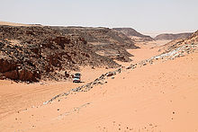
The journey usually begins in Cairo, el-Baḥrīya, el-Chārga or ed-Dāchlaso that advance goals like that very often White desert or the stalactite cave el-Gāra be visited. In the capital of ed-Dāchla, in Courage, most expeditions meet to head for the Gilf Kebir National Park from here.
On the way to Gilf Kebir National Park
There are several sights to see when driving to the Gilf Kebir National Park:


- The first stop is on 1 Samīr Lāmā rock and a short distance away at Sugar Loaf Rock. They are limestone rocks that rise from the surrounding sandy desert. The almost white sandstone is very porous and can be rubbed off very easily. Its properties resemble small pieces of sugar. A memorial plaque for the Egyptian desert explorer was placed on the Samīr Lāmā rock in 2005. A short distance of 2.5 kilometers in a south-westerly direction leads to the rock group 2 Sugar Loaf.

- That becomes rarer
 3 Djedefre water mountain visited. In addition to prehistoric depictions of animals, text inscriptions report on expeditions of the ancient Egyptian kings Cheops and his successor Djedefre (Radjedef) to the western desert.

- 4 Abu Ballas is an antique jug warehouse for caravans traveling to Kufra or led to Gebel el-ʿUweināt. The only known pack animals in ancient Egypt, the donkey, needed water after 200 kilometers at the latest, which was deposited at these stations. But the rock offers even more: on its south side, animals and a hunter were carved in ancient Egypt.

- On the further way to the national park one encounters a large area with so-called. 5 Mud lions or Yardangs in the Wādī el-Aswad (see under Abu Ballas), which were formed by wind erosion from the sediments of former Playa lakes, which were formed by rainwater.

Kamal-ed-Din plateau


- In the following one reaches the southeastern tip of the 6 Gilf Kebir Plateau. This sandstone massif consists of two parts. The southeastern one is known as the Kamal-ed-Din plateau.

- The 7 Wadi el-Bacht, "The Lucky Valley", on the east side of the Kamal-ed-Din plateau is an archaeological site. The rear area, separated by a sand dune, was a settlement in the Neolithic (New Stone Age). This is a similar site 8 Wādī el-ʿArḍ el-Achḍar, "Valley of the Green Ground".[2]
- Other destinations are usually the rock group 9 Eight Bells, in the southeast of which the British created a landing site during World War II, and that 10 Monument to Prince Kamal ed-Din. Between the two is at 11 22 ° 39 ′ 1 ″ N.26 ° 13 '40 "E an archaeological find area in which, among other things, blades and knives made of flint, millstones and a street egg surrounded by a modern stone circle can be found.


- There are hardly any rock carvings in the Kamal-ed-Din plateau. The only place is that 12 Qantara cave, also Shaw cave, with depictions of cattle.
From here it could go to the Abu-Ras Plateau, the northwestern part of the Gilf-Kebir Plateau. Most of the time, however, the journey does not continue until Gebel el-ʿUweināt in the triangle Egypt-Sudan-Libya.
Desert between Gilf Kebir and Gebel el-ʿUweināt


The desert between Gilf Kebir and Gebel el-ʿUweināt is not empty. Usually, different routes are also used.
- The more westerly route leads past the Peter and Paul Mountains to the 13 Clayton craters. These ring-shaped sandstone massifs with a diameter of about 1.5 kilometers were lifted by magma, which, however, already solidified in the earth's crust. Twelve kilometers northwest of the crater are the inaccessible ones 14 Peter and Paul Mountains.


- The eastern route passes the 15 Three castles. These are three sandstone rocks on which the British laid a vehicle depot during World War II. This depot was exposed by László Almásy during "Operation Salam" in 1942.

Gebel el-ʿUweināt
- The 16 Gebel el-Uweinat is located in the three-country corner of Egypt-Sudan-Libya and is one of the highlights in the Gilf Kebir National Park. De facto The entire massif was covered with rock engravings and paintings in the Holocene period, between around 8,500 and 3,500 years BC. Chr., Provided.

- One of the most beautiful and easy to reach valleys is that 17 Karkur Talh in the northeast the Gebel el-ʿUweināt. Animals such as giraffes, cattle, sheep, gazelles, antelopes and ostriches as well as hunters and shepherds were depicted in countless thousands of places.

Abu-Ras Plateau and Egyptian Sand Sea


- On the way back you get to the 18 Abu-Ras plateau, the northwestern part of the Gilf Kebir Plateaus.
- At the southwestern tip of the Abu-Ras plateau are the most important rock caves in which rock paintings were made: the Swimmers' den and adjacent Cave of the Archers in the 19 Wadi Sura ("Bildtal") as well as the one that was only discovered in 2002 20 Foggini Mistikawi Cave, also Den of the Beasts called, which even dwarfs the swimmers' cave.


- On the 21 ʿAqaba Pass one reaches the surface of the plateau. In the vicinity of the Samīr-Lāmā monument you have a magnificent view of one of the valleys, and it is also called like this: 22 Bellevue, the beautiful view". After a further 50 kilometers in a north-westerly direction, one arrives at the 23 Territory of 10,000 desert roses, the real roses from Jericho.


- There are several valleys like that on the north side of the Abu-Ras Plateau 24 Wādī Talḥ, "Valley of the umbrella acacias", that 25 Wadi Abd el-Malik, “Valley of the [Shepherd] ʿAbd el-Mālik”, and that 26 Wadi Hamra, "The red valley". In the last two valleys there are both rock carvings and vegetation. The Wadi Hamra is considered the more beautiful.

- The journey through the Wadi Abd el-Malik leads to the southern foothills of the 650 km long 27 Egyptian sand lake. This already exists in the south of this sandy lake 28 Libyan glass territory, Silica Glass Field. This amorphous, whitish to dark green translucent natural glass is unique in the world and can only be found here. The origin of the glass has not yet been clarified. Taking Libyan glasses is now restricted or even banned. The sand lake is ideal for walks in the plains and on the dune ridges. There is some adventure when the vehicles cross the sand dunes.


Travel preparation
Due to the expense of vehicles, navigation devices, and satellite telephones, you will hardly be able to undertake such a trip on your own. In order to achieve a reasonable price-performance ratio, at least four people should take part in such an undertaking.
Some German expedition travel companies offer trips lasting two to three weeks. The demand is relatively low, even lower for the three-week tours. It is therefore advisable to consider alternative dates right away. A German-speaking tour guide will only be provided in exceptional cases.
The German tour operators rely on licensed Egyptian companies. These include (in alphabetical order):
- Ahmed Safari Camp, Bawiti, Bahariya. Tel.: 20 (0)2 3847 0001, Fax: 20 (0)2 3847 2090, Email: [email protected].
 Language skills are English and Arabic.
- Dabuka, Courage, Dakhla; 2 Osman Buildings, Corniche el-Nile, Maadi, Cairo. Tel.: 20 (0)2 2525 7687, Email: [email protected]. The company owner, Tarik el-Mahdi, speaks German, English and Arabic. Tel. The Germany office: (0) 89 6385 6347, weekdays 1 pm-5pm.
- Pan Arab Tours, Saudi-Egyptian Building 5, El Nozha St., Heliopolis, Cairo. Tel.: 20 (0)2 2418 4409, (0)2 2418 4419, Fax: 20 (0)2 2291-3506, Email: [email protected]. Germany office: Walter-Kolb-Str. 1–7, 60594 Frankfurt, Tel .: 49 (0) 69 665-756-0. The largest of the companies mentioned.
- White Desert Tours, Bawiti, Bahariya. Tel.: 20 (0)2 3847 3014, Fax: 20 (0)2 3847 2322, Email: [email protected]. The owner, Peter Wirth, and his wife Miharu speak German, English and Japanese.
- Zarzora expedition, 12b Mahmoud Azmi Street, Zamalek, 11211 Cairo. Tel.: 20 (0)2 3340 9435, Mobile: 20 (0)100 118 8221, (0)100 555 6177, Fax: 20 (0)2 3340 9435, Email: [email protected]. The manager is Ahmed el-Mestikawi.
getting there
A trip to the Gilf Kebir National Park is an elaborate desert expedition lasting about two to three weeks. It is usually carried out by experienced local drivers and guides from the valleys Bahrīya or ed-Dāchla carried out. You need several all-wheel drive all-terrain vehicles, sufficient water and provisions and a satellite phone. And local knowledge.
Sufficient spare parts and spare tires must be carried with you. It should be possible to repair the vehicles without the aid of special tools and electronic test equipment.
mobility
Outside the rock massifs, the subsoil is sandy or stony. There are also rubble in the rock massifs. Appropriate footwear should be worn.
kitchen
All food and drinks, as well as dishes and stoves, must be carried with you during the entire expedition. Since there is not too much space in and on the vehicles, you have to limit yourself to the bare essentials. In any case, there must be enough water. You need it for drinking (mineral water), for limited personal hygiene, for cooking and for washing dishes.
All food must be durable during the expedition even without a refrigerator. These are e.g. bread, cheese, jam, pasta, tins of sausage and meat, but also fruit such as apples and bananas and vegetables such as cucumbers and tomatoes. Egyptian flatbread is durable, but hardens after just a few days. You can count yourself lucky when there is someone who can bake bread.
Organic waste can be buried. All other waste must be taken back.
accommodation
So far, no places have been prepared for camping.
You can sleep in a tent or on a mat in the open air.
It's always windy in the desert. That is why setting up a tent is not so trivial. Of course, the tent entrance must face the leeward side. However, the wind load can sometimes be so great that the tent is carried away. Particular care should be taken when hammering in the pegs. There are special, wider sand pegs for sandy subsoil. It is also sensible to weigh down the tent with luggage, water bags, etc. The tents should be impermeable to sand and the zippers should be sand-proof. When choosing tents, you should use the usual outdoor tents and rather expedition tents.
The vehicles are placed next to each other at a distance of about three meters. A windbreak is then stretched between the vehicles on at least one side.
behaviour rules
There are few rules of conduct for travelers, because the natural beauties are fragile, and the sight of non-rotting souvenirs of modern times is not exactly edifying either.
- The most important principle is to leave all places as you found them yourself. Later travelers want to enjoy the same experience.
- If possible, only ski on the existing slopes. Landscapes just look more beautiful without car tracks. With new wagon tracks one destroys at least the crust on the surface, but maybe also geological features, vegetation or archaeological evidence.
- Take all rubbish with you and don't leave it in the desert. For example, matches, cigarettes, paper and vegetable waste take around 1 year to rot, aluminum cans around 100, plastic around 1,000 and glass around 5,000 years. Organic waste should be buried.
- Bring your fuel and do not use any plants or plant debris on site to maintain a campfire or cook.
- Intervene as little as possible in the flora and fauna. Animals and plants also have a right to life, they may seriously interfere with the ecosystem. Do not collect or destroy plants. Animals are also not allowed to be collected, killed or hunted.
- Leave everything where it is. This applies to rocks, minerals, fossils and archaeological remains. Others want to see it too. Archaeological finds that have been torn from their find environment are much less able to tell posterity about prehistoric times. Attempts to export archeological artifacts will be punished under Acts 102 and 117 (Antiquities Act) of 1983. In addition to fines between LE 50,000 and LE 250,000, prison sentences of up to 25 years can also be imposed.
security
| The Foreign Office of the Federal Republic of Germany has one for this country Travel warning released (Web link). The Federal Foreign Office urgently warns against traveling to the desert areas in southwest Egypt. In the past, travelers have been robbed and kidnapped several times. The area was declared a restricted military area. Travel to this area is generally only permitted with a special permit from the military. Date of the last travel warning: 26.07.2018. |
The area of the Gilf Kebir National Park, especially south of the Gilf Kebir Plateau, is used for the transport of internationally operating and armed smugglers' gangs. Actually, they want to remain unobserved. But they also do not shy away from raids on the rich tourists and take away everything that is worth money. You shouldn't rely on the protection of the police, but rather on the negotiating skills of the local drivers and guides.
A permit from the Egyptian military is required to travel south of the 23rd parallel. During the trip you will be accompanied by armed police officers and a military officer. For trips to Gilf Kebir, there is in Courage its own safari department, which also has the necessary police escort (Tourist Safari Police Escort) and their vehicles. The compulsory service, which is independent of the number of travelers, is of course chargeable. Each of the two support vehicles costs around LE 2,500. The escort officer costs about $ 100 a day.
British forces laid mines in several places during World War II that have not yet been cleared. Only some of the areas are cordoned off. The well-known mined areas in the Gilf-Kebir plateau include the Wadi el-Firaq, the Wadi Wasʿ (Wadi Wassa) and the side valleys of the ʿAqaba Pass. Other mined areas are the Peter and Paul rocks and marked areas in the entrance area to the Karkur Talh (at 1 22 ° 2 ′ 45 ″ N.25 ° 7 '52 "E and 2 22 ° 4 ′ 30 ″ N.25 ° 2 ′ 48 ″ E).
Communication is essential for survival. On such expeditions have to Satellite phones are carried.
climate
The best time to travel is November to early March.
The climate is warm to hot and dry all year round. Rainfalls are an absolute exception. The rain duration rarely exceeds a few minutes. Heavy rainfall can occur every several years. In December and January temperatures can drop below 0 ° C.
| Dāchla | Jan | Feb | March | Apr | May | Jun | Jul | Aug | Sep | Oct | Nov | Dec | ||
|---|---|---|---|---|---|---|---|---|---|---|---|---|---|---|
| Mean highest air temperature in ° C | 22 | 24 | 28 | 34 | 37 | 39 | 39 | 38 | 36 | 33 | 27 | 23 | O | 31.7 |
| Average air temperature in ° C | 12 | 14 | 18 | 24 | 28 | 31 | 31 | 30 | 28 | 24 | 18 | 14 | O | 22.7 |
| Mean lowest air temperature in ° C | 4 | 5 | 9 | 13 | 18 | 22 | 22 | 22 | 20 | 16 | 10 | 5 | O | 13.8 |
| Precipitation in mm | 0 | 0 | 0 | 0 | 0 | 0 | 0 | 0 | 0 | 0 | 0 | 0 | Σ | 0 |
Dakhla, Egypt: Climate, Global Warming, and Daylight Charts and Data, accessed November 17, 2009. | ||||||||||||||
The sandstorms are feared Chamsīn (Arabic:خماسين, Chamāsīn, orخمسين, Chamsīn) to be named. These are hot south and south-east winds that stir up the desert sand and carry it away with them. The causes are low pressure areas in the Mediterranean area. The storms can occur all year round, their main season is the months of March to May (a period of 50 days after the beginning of spring - the Arabic word also refers to this period), and they also occur more frequently in autumn. The storms last for several days and are in large parts Egypt to be found. Far more dangerous, but more localized, are the sand whirlwinds, called soba'a. Here you have to protect your eyes and electronic devices in any case. The storms often contribute to flight plans no longer being adhered to. In 2006, the first sandstorm occurred at the end of February (locals said they hadn't seen it for 20 years), and somewhere in the dust, even the pyramids of Gīza were barely visible.
health
There are no medical treatment options during the expedition. If necessary, carry a sufficient supply of medication with you.
Think about sun protection. Warm clothing is also required for the nights. You need about 3 liters of water per day to drink.
The expeditions to Gilf Kebir National Park are considered easy. There are no special requirements for health, endurance, strength and athleticism.
literature
- Books and essays
- : Riddle of the desert. Leipzig: Brockhaus, 1926. Translation of the novel "Lost Oases".
- : L’exploration du Désert Libyque. In:La geographie / Société de Géographie, ISSN0001-5687, Vol.50 (1928), Pp. 171-183, 320-336.
- : An Expedition to the Gilf Kebir and 'Uweinat, 1938. In:The Geographic Journal (GJ), ISSN1475-4959, Vol.93,4 (1939), Pp. 281-313.
- : Suggesting natural heritage sites in remote desert areas: The proposal for a National Park in the Gilf Kebir Egypt. In:Ayyad, M.A. ; Kassas, M.; Ghabbour, S.I. (Ed.): Conservation and Management of Natural Heritage in Arab Countries: Proceedings of the third regional training course. Cairo: Egyptian National Commission for Unesco, 1996, Pp. 35-41; PDF (English and Arabic editions).
- : Swimmers in the desert: in search of the Zarzura oasis. innsbruck: Haymon, 1997, ISBN 978-3-85218-248-3 .
- : Gilf Kebir National Park. Verona: Geodia, 2009, ISBN 978-88-87177-86-2 .
- cards
- : Oases of Egypt: Map of the Western Desert. Verona: Geodia, 2007, ISBN 978-88-87177-76-3 .
- Gilf Kebir National Park is shown from north to south on the Russian general staff maps (1: 200,000) G-35-26, G-35-27, G-35-32, G-35-33, F-35-02, F-35-03, F-35-08, F-35-09, F-35-14, and F-35-15 shown.
Individual evidence
- ↑ 1,01,1Natural Protectorates (Egyptian Environmental Affairs Agency, in English).
- ↑: Excavations in Wadi el Akhdar, Gilf Kebir (SW Egypt). Cologne: Heinrich Barth Inst., 1996, Africa praehistorica; 8th, ISBN 978-3927688124 .
Web links
- Fliegel Jezerniczky Expeditions by András Zboray