 Bellevue in the Gilf Kebir Plateau | ||
| Gilf Kebir Plateau هضبة الجلف الكبير | ||
| Governorate | New valley | |
|---|---|---|
| height | 1,015 m | |
| no tourist info on Wikidata: | ||
| location | ||
| ||

The Gilf Kebir Plateau (also Gilf-el-Kebir plateau, Arabic:هضبة الجلف الكبير, Haḍabat al-Ǧilf al-Kabīr, „Plateau 'the great cliff / the great barrier' '") Is a sandstone-encased basalt plateau up to 300 meters high in the west of the Western desert in the egyptianGovernorateNew valley. This plateau is also the namesake of the Gilf Kebir National Parkat the center of which it lies. It is famous for its diverse landscapes and prehistoric rock carvings. Here László Almásy discovered the legendary ones in 1932/1933 Swimmer in the desert in the Wadi Sura.
background

location
The Gilf Kebir Plateau, a dry and almost inhospitable ferruginous sandstone massif in the southwest of the Western desert located at the south end of the Egyptian sand lake, about 750 kilometers from the Nile and 1000 kilometers from the Mediterranean Sea. The massif rises 300 meters above the 700 meter high plain. The wadis, the valleys, were cut into the rock by ancient rivers in the Tertiary.
Strictly speaking, the Gilf Kebir Plateau, which is around 15,700 square kilometers in size, consists of two separate plateaus: the Abu-Ras Plateau (Arabic:هضبة أبو رأس, Haḍabat Abū Raʾs) in the northwest and the Kamal-ed-Din plateau (Arabic:هضبة كمال الدين, Haḍabat Kamāl ad-Din) in the southeast, which are separated by the ʿAqaba Pass (“steep ascent”) and the Wādī ʿAssib, which Hubert Jones Penderel discovered in 1932. The Kamal-ed-Din plateau is the larger and higher plateau. The names of the sub-plateaus are more recent and therefore only recorded on new maps. In the west of the Abu-Ras-Plateau is the name giving it Gebel Abū Raʾs (Mountain "father of the summit"), to which it is the counterpart in the east Gebel Umm Raʾs (Mountain "mother of the summit") there.
The Kamal-ed-Din plateau extends over 125 kilometers in a north-south direction and 80 kilometers in an east-west direction. It occupies an area of 7,500 square kilometers. The highest point is 1,091 meters above zero. Most of the wadis are on its east side. From north to south these are the 15 kilometer long Wādī Maschī (Arabic:وادي مشي, „the walking valley"), Wādī eḍ-Ḍayyiq (وادي الضيق, „the narrow valley"), The Wādī el-Maftūḥ (وادي المفتوح, „the open valley"), the Wādī el-Bacht (وادي البخت, „the lucky valley"), The Wādī el-Gazāʾir (Wādī el-Gazāyir,وادي الجزائر, „the isolated valley") And the Wādī Wasʿ (Wadi Wassa,وادي وسع, „the wide valley"). The Wādī Wasʿ in the east has a connection to the Wādī el-Firāq (وادي الفراق, „the separated valley") in the West. However, this stretch is not passable because both wadis were mined in the Second World War. Approximately in the middle between Wādī Wasʿ and Wādī el-Firāq begins the 35 km long Wādī el-ʿArḍ el-Achḍar (Arabic:وادي العرض الأخضر, „Valley of the green ground"). In the southeast is that Wadi Eight Bells. The plateau also includes the Qanṭara cave and the Monument to Prince Kamal ed-Din at the southern tip of the plateau.
The Abu-Ras plateau extends over 140 kilometers from north to south and about 40 kilometers from west to east. In the southwest are that Wādī Ṣūra (Arabic:وادي صورة, „Bildtal") and the Foggini Mistikawi Cave (Den of the Beasts). In the north cut through the Wādī Ṭalḥ (وادي طلح, „Umbrella Acacia Valley"), the Wādī ʿAbd el-Mālik (وادي عبد المالك, „Valley of the ʿAbd el-Mālik") and the el-Wādī el-Ḥamrāʾ (الوادي الحمراء, „the red valley“) The mountain range. The two most important pass roads to the Abu Ras Plateau are the ʿAqaba Pass and the Lama Monod Pass.
Research history
Of course, Gilf Kebir was settled in the Holocene, of which the numerous rock engravings and paintings count. Since around the ancient Egyptian Empire, the Abū Ballāṣ path to Kufra or for Gebel el-ʿUweināt past. The few, but every few years, rainfall were made by camel and cattle herders until modern times Kufra used to graze their animals in the valleys of the Abus-Ras plateaus. However, no knowledge of this reached the Nile Valley or even the rest of the world. Maybe also because it had no name.
The first European to see the southeastern tip of the Gilf Kebir Plateau was William Joseph Harding King (1869–1933). In 1909 he went on a 200-kilometer camel excursion south-westerly from ed-Dāchla out. A second excursion in 1911 was only 50 kilometers further.[1] The major and pilot Hubert Jones Penderel (1890–1943) reported that in 1917 John Ball (1872–1941) and a Lieutenant Moore passed the Gilf Kebir Plateau on patrol.[2]
The “official” discovery is attributed to Prince Kamal ed-Dīn Ḥusein (1874–1932), who explored the plateau from 1923–1926, partially mapped it and gave it its current name.[3] He was followed by a major from 1930 Ralph Alger Bagnold (1896–1990),[4] British Army officer and later founder of the Long Range Desert Group, a special unit of the British Army for exploring the Libyan Desert.
The years 1932 and 1933 became the time of the Hungarian desert explorer László Almásy (1895–1951), who undertook several expeditions to the Gilf Kebir together with Sir Robert Alan Clayton-East-Clayton (1908–1932), Hubert Wilson Godfrey Penderel (1890–1943) and the British surveyor Patrick Clayton. One of his goals was to discover the legendary Zarzūra. Through the combined use of vehicles and an airplane, a i.e. 60G Gipsy Moth from the de Havilland Aircraft Company, they were able to gain significantly more knowledge than any other desert researcher before. So in 1932 Penderel discovered the loophole, that Gap, between the two plateaus, which Almásy gave the name ʿAqaba Pass.[5] Other discoveries included the valleys on the north side of the Abu-Ras plateau and the famous one in 1933 Wādī Ṣūra with the cave of the swimmers, a cave with prehistoric rock paintings. In the same year several rock carvings were made by German ethnologists Leo Frobenius (1873-1938) and Hans Rhotert (1900-1991) recorded. With the beginning of the Second World War, their ways should part. Almásy was henceforth in action for the German armed forces.
The Briton Ralph Alger Bagnold also continued his explorations. In 1938 they found rock carvings in the Wādī ʿAbd el-Mālik by R.F. Peel, and it was the first time archaeological investigations were carried out by Oliver Humphrys Myers (1903-1966) in Wādī el-Bacht.[6]
All research activities were suspended during the Second World War. The first mission after the war took place in 1969 by the Belgian Misonne. Since the 1970s, it has been possible to map the Gilf Kebir Plateau using satellite images of the NASA and the cosmic armed forces of the Soviet Union to be brought to a conclusion.
Since the 1970s there has been another successful desert researcher with Samīr Lāmā (1931-2004). He passed on his knowledge to many interested parties. With the travel agency he founded, it was also possible for tourists to discover the beauty of the desert for themselves. The modern expedition companies, which would not even exist without him, also live from his knowledge.
Archaeological research to clarify the prehistoric settlement was carried out in Wādī el-Bacht[7] and in Wādī el-ʿArḍ el-Achḍar[8] by the Heinrich Barth Institute carried out since the 1990s.
The Gilf Kebir Plateau in Art
In 1992 the Canadian Scripture was published Michael Ondaatje (* 1943) his world-famous novel The English patient. Four people, including Count Almásy, are stranded in the abandoned Villa San Girolamo in Tuscany and are working on their memories.
The novel was based on in 1996 by Anthony Minghella (1954–2008) filmed with Ralph Fiennes, Juliette Binoche, Willem Dafoe and Kristin Scott Thomas. The film received nine Oscars.
getting there
There are different ways to get here:
- Of Courage in ed-Dāchla you can reach the Gilf-Kebir-Plateau via the intermediate stations Samīr Lāmā rock, Abū Ballāṣ and Eight Bells.
- Of the Egyptian sand lake you can reach the Abu-Ras-Plateau via the Wādī ʿAbd el-Mālik and the 1 Llama Monod Pass(23 ° 58 ′ 21 ″ N.25 ° 21 ′ 20 ″ E).
- From Gebel el-ʿUweināt there are two principal routes to the Gilf Kebir plateau. The eastern route leads east past the Peter and Paul rocks and passes the Clayton crater. The western route leads almost exactly in a northerly direction over the Three castles to the Wādī Ṣūra.
A permit from the Egyptian military is required to drive to Gebel el-ʿUweināt. During the trip you will be accompanied by armed police officers and a military officer. For trips to the Gilf Kebir there is a separate safari department in Mū,, which also provides the necessary police escort and their vehicles. The mandatory service is of course chargeable.
Tourist Attractions
Sights in the Kamal-ed-Din plateau


- The 2 Wādī el-Bacht
 in the Wikidata database") (23 ° 12 '32 "N.26 ° 16 '37 "E.) is an archaeological site. The rear part of the wadi is separated from the front part by a sand dune about 30 meters high and 650 meters wide. In the Neolithic (New Stone Age), about 10,000 years ago, there was once a lake up to 9 meters deep and about 100,000 cubic meters of water. In the Holocene, nomadic hunters and gatherers settled here. Later on, sedentary settlers also ran livestock.
(23 ° 12 '32 "N.26 ° 16 '37 "E.) is an archaeological site. The rear part of the wadi is separated from the front part by a sand dune about 30 meters high and 650 meters wide. In the Neolithic (New Stone Age), about 10,000 years ago, there was once a lake up to 9 meters deep and about 100,000 cubic meters of water. In the Holocene, nomadic hunters and gatherers settled here. Later on, sedentary settlers also ran livestock.
- The 3 Wadi Eight Bells

 (22 ° 48 ′ 33 ″ N.26 ° 14 '14 "E) is characterized by a chain of eight bell-shaped hills of volcanic origin. In the southeast of this range of hills, an airport was created by the British armed forces during World War II. The path markings, a large, narrow arrow and the lettering can still be seen today.

- The 4 Monument to Prince Kamal ed-Din(22 ° 41 ′ 45 ″ N.25 ° 52 ′ 21 ″ E) was built in 1933 by László Almásy for his patron, Prince Kamal ed-Din, one year after his death.

- The cave 5 Maghārat el-Qanṭara(22 ° 58 ′ 56 ″ N.25 ° 59 ′ 11 ″ E) (Shaw cave) is the only known prehistoric rock depiction in the Kamal-ed-Din plateau to this day. About half a meter above the ground one discovers the representations of a herd of differently drawn cattle and a farm. The age of these drawings is estimated to be around 8,000 years.

Sights in the south of the Abu-Ras plateau


- in the 6 Wādī Ṣūra(23 ° 35 ′ 37 ″ N.25 ° 14 ′ 4 ″ E) rock paintings were first discovered in 1933. László Almásy found the famous cave of swimmers and the hunters cave here. In the cave of the swimmers you can see people lying down and stretching out their arms as if they were swimming. Furthermore, slim people with an almost triangular torso are shown. In the Jägerhöhle, 15 meters further, you will find hunters with bows and arrows, animals, cattle and women.

- It wasn't until 2002 that the 7 Foggini Mistikawi Cave(23 ° 39 ′ 12 ″ N.25 ° 9 '35 "E) (also Den of the Beasts) discovered. The calls of its discoverer, the Italian Jacopo Foggini, “thousands, thousands” heralded a sensation. There are hundreds of rock paintings and engravings on the walls, which were probably created over a period of a thousand years. Numerous people, hunters and even swimmers are visible. There are also numerous wild animals such as giraffes, gazelles and ostriches, but no domesticated animals. However, several headless animals are a specialty.

Sights on the Abu-Ras plateau


- The ride over the 8 ʿAqaba Pass(23 ° 24 '46 "N.25 ° 42 ′ 28 ″ E), "Steep ascent", is one of the most impressive tours. In three steps you reach the plateau with a height difference of 300 meters. The last stage is usually overcome at 1 23 ° 30 '22 "N.25 ° 38 ′ 41 ″ E.
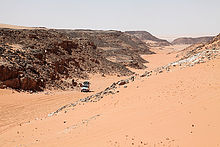
- About 16 kilometers to the northwest is one of the most beautiful viewpoints on the plateau. The Egyptian desert explorer Sami Lama called it his 9 Bellevue(23 ° 30 '15 "N.25 ° 36 '5 "E), the beautiful view he showed all his guests. The hotelier Peter Wirth and his wife Miharu erected the memorial stone here in gratitude with the consent of Samīr's wife Waltraut "Wally". Without Samīr Lāmā, there would be no expedition to the Gilf Kebir National Park today. All guides working today live from his knowledge. The basalt and rose granite memorial stone reads in English:

- In Memoriam - In memory of
- Samir Lama (1931-2004)
- Actor & Desert Explorer - Actor and desert explorer
- This is reached after about 50 kilometers in a north-westerly direction 10 Territory of 10,000 desert roses(23 ° 52 ′ 50 ″ N.25 ° 19 ′ 18 ″ E). For several kilometers, the area has dried up with thousands real roses from Jericho (Anastatica hierochuntica, Resurrection plant) covered. The rose is an annual cruciferous plant. It forms small white flowers. At the end of the growth phase, the rose will curl up to protect its seeds. Even if it breaks off, the rose will keep rolling without losing any seeds. If the plant comes into contact with water, it catapults some of the seeds into the environment in order to produce new life. This is a purely physical process that can be repeated any number of times.

Sights in the north of the Abu-Ras plateau

- The 11 el-Wādī el-Ḥamrāʾ(23 ° 51 '8 "N.25 ° 27 '4 "E) is probably the most beautiful valley on the north side, the name of which derives from the sand drainage interspersed with iron oxides. It has the most extensive vegetation of all valleys on the northern edge, including umbrella acacias, caper bushes (Maerua crassifolia), Fagonia and the cruciferous family Zilla spinosa. In three places there are rock engravings with images of animals such as giraffes, gazelles, antelopes, cattle and dogs.

- The 12 Wādī ʿAbd el-Mālik(23 ° 55 '59 "N.25 ° 22 ′ 20 ″ E) was made after a camel herder Kufra named. It can be easily accessed via the 13 Llama Monod Pass(23 ° 58 ′ 21 ″ N.25 ° 21 ′ 20 ″ E) can be reached from the Abu-Ras plateau and leads to Egyptian sand lake. In the middle part of the valley there are rock engravings of animals. In the so-called Peel Cave there are also rock paintings of cattle species. László Almásy believed that the three valleys on the north side of the Abu-Ras plateau were the legendary oasis Zarzūra (Zerzura) are.

kitchen
In the area of the Gilf-Kebir plateau you can have a picnic in different places. Food and drinks must be brought along. Rubbish must be taken with you and must not be left lying around.
accommodation
Tents must be brought along for the overnight stay at some distance from the plateau.
literature
- Books
- : Swimmers in the desert: in search of the Zarzura oasis. innsbruck: Haymon, 1997 (3rd edition), ISBN 978-3852182483 .
- : The English patient. Munich [and others]: Hanser, 1993. Numerous reprints.
- cards
- : Oases of Egypt: Map of the Western Desert. Verona: Geodia, 2007, ISBN 978-8887177763 .
- The Gilf Kebir Plateau is shown from north to south on the Russian General Staff maps (1: 200,000) G-35-26, G-35-27, G-35-32, G-35-33, F-35-02, F-35-03, F-35-08, and F-35-09 shown.
Individual evidence
- ↑: Travels in the Libyan Desert. In:The Geographical Journal (GJ), ISSN1475-4959, Vol.39 (1912), Pp. 133-137, 192.
- ↑: The Gilf Kebir. In:The Geographical Journal (GJ), ISSN1475-4959, Vol.83 (1934), Pp. 449-456.
- ↑: L’exploration du Désert Libyque. In:La geographie / Société de Géographie, ISSN0001-5687, Vol.50 (1928), Pp. 171-183, 320-336.
- ↑: Journeys in the Lybian Desert 1929 and 1930. In:The Geographical Journal (GJ), ISSN1475-4959, Vol.78 (1931), Pp. 13-39.
- ↑L. Almásy, op. Cit., P. 121.
- ↑: An Expedition to the Gilf Kebir and 'Uweinat, 1938. In:The Geographic Journal (GJ), ISSN1475-4959, Vol.93,4 (1939), Pp. 281-313.
- ↑Linstädter, Jörg (Ed.): Wadi Bakht: Landscape archeology of a settlement chamber in Gilf Kebir. Cologne: Heinrich Barth Inst., 2005, Africa Praehistorica; 18th, ISBN 978-3927688254 .
- ↑: Excavations in Wadi el Akhdar, Gilf Kebir (SW Egypt). Cologne: Heinrich Barth Inst., 1996, Africa praehistorica; 8th, ISBN 978-3927688124 .