 Limestone rocks in the shape of a mushroom, White Desert | ||
| White Desert National Park محمية الصحراء البيضاء | ||
| no tourist info on Wikidata: | ||
| ||

The White Desert National Park (engl. White Desert National Park, Arabic:محمية الصحراء البيضاء الطبيعية, Maḥmīyat aṣ-Ṣaḥrāʾ al-baiḍāʾ aṭ-ṭabīʿīya, „White Desert Nature Reserve“) Is a 3,010 square kilometer Nature reserve in Egypt about 30 kilometers north of the depression el-Farafra. The protected area is one of the most extraordinary areas in the Western desert. It ranges from about Crystal mountain in the north to Table Mountain et-Tabalī to the south (about 50 kilometers) and from Hidden Valley (Hidden Valley) in the west over 100 kilometers to the east into the here nameless desert. In the west and south there are two more buffer areas with an area of 971 square kilometers.
background
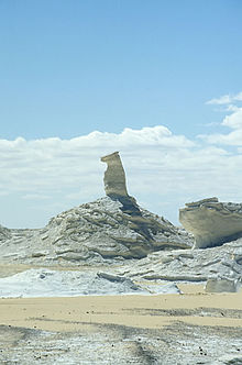
The White Desert area was declared a protected area in 2002. The landscape is characterized by limestone and chalk cliffs. The desert was created from the remains of microscopic sea creatures whose habitat was here around 80 million years ago. After the sea disappeared, winds shaped today's rocks. Depending on the composition or hardness of the rocks and their sequence of layers, bizarre structures such as mushrooms, tower-like or finger-like structures emerged over time. With a little imagination you can see dogs, camels and other creatures in them.
But this part of the world is not dry. There are three important sources in the national park: ʿAin Chadra (ʿAin el-Wādī), ʿAin es-Serw and ʿAin el-Maqfī.
These springs provide vegetation with palms, tamarisks and acacias. And if you have a little time and luck, you can also observe gazelles, desert foxes, small rodents, geckos and much more here.
There are now around 50,000 tourists who travel here annually from el-Farafra or el-Bahriya. Trips over Christmas and Easter are particularly popular. Christmas - of course, because they are then white, but without snow.
The tourist crowds naturally make various protective measures necessary. With funds from the Italian government and the Egyptian Ministry of the Environment, slopes have been laid out and campsites have been designated for overnight stays.
getting there

The easiest way to get to the source is via the trunk road from el-Farāfra to el-Baḥrīya.
The national park has six entrances, from north to south: Aqabat entrance (to the east, track 1) south of the Aqabat pass (Naqb el-Aqabat), after a further 10 kilometers the el-Babein entrance (to the west, Track 3), after a further two kilometers the Ain-Khadra entrance (to the east, Track 2), after a further six kilometers the main entrance (main entrance, to the east Track 1 and 2), after four kilometers the Bir-Regwa entrance ( to the east, track 4) and after six kilometers the el-Qabur entrance (to the west, track 3).
Another route is the 50 km long so-called. English track (English route), which branches off about 10 kilometers north of the crystal rock to the southeast into the desert and at the source ʿAin es-Serw hits track 1.
mobility
Only all-terrain means of transport can be used in the park. These can be off-road four-wheel drive vehicles, motorcycles, camels or your own feet. The latter is perhaps only for hikers who are tough.
Entrance fee
An entrance fee must be paid to visit the national park. US $ 5 per person during the day (LE 5 for Egyptians), LE 10 in addition for an overnight stay in the national park and $ 5 per vehicle (LE 5 for Egyptians). Entry is free for members of the local non-governmental organization who also look after the park. At the beginning of 2009, however, it was not even clear who should collect the money.
Tourist Attractions


The sights are described along their routes. Tracks 1, 2 and 4 lead to the east, track 3 to the west.
Track 1
Track 1 (purple) is the longest at 65 kilometers. It begins at the main entrance, goes first to the southeast and forms a large round that ends far to the north at the Aqabat entrance. About one and a half kilometers after the main entrance on the south side of the track you can see the rock formations 1 el-Chiyam(27 ° 20 ′ 51 ″ N.28 ° 10 ′ 20 ″ E), also el-Khiyam, Arabic:الخيام, al-Chiyam, „the tents", and 2 Aisch el-Ghurab(27 ° 21 '22 "N.28 ° 10 ′ 16 ″ E), also The mushrooms (the mushrooms), Arabic:عيش الغراب, ʿAish al-Ghurāb, „the raven bread". Rest area 13 is located near the entrance.
About 7 kilometers to the southwest is a single limestone cliff with the name The mushroom west of the slope. Now follows a longer route - about 25 kilometers - to the source ʿAin es-Sarw (also Ain / Ayn el-Serw / Serv, Ain / Ayn Sirwal, Arabic:عين السرو, ʿAin as-Sirw, „Source on an elevation"). Rest area 11 is also located here. After another four kilometers to the north, you will reach the source ʿAin el-Maqfī (also Ain / Ayn Makfee, Arabic:عين المقفي, ʿAin el Maqfī), also ʿAin Abū Hawas called, with rest area 12.
The source 3 ʿAin es-Sarw(27 ° 22 ′ 12 ″ N.28 ° 20 ′ 50 ″ E) is located on a small hill, surrounded by palm trees.
The stone-edged spring 4 'Ain el-Maqfī'(27 ° 24 '56 "N.28 ° 20 ′ 56 "E) also has palm trees on one side.
From now on it goes west again. After 15 kilometers the 5 Double rocks(27 ° 26 '8 "N.28 ° 15 ′ 39 ″ E) (Double or twin peaks) at el-Musarraya / el-Musharaya. On top of a hill there are two limestone cliffs. Resting place 15 is also nearby. After a further six kilometers you will reach the 6 Aqabat entrance(27 ° 29 ′ 8 ″ N.28 ° 14 ′ 30 ″ E).
Track 2
Track 2 (green) is about 17 kilometers long and starts at the Ain Khadra entrance. After driving about 8 kilometers in a south-easterly direction you will reach the source 7 ʿAin Charāʾ(27 ° 22 ′ 18 ″ N.28 ° 13 '12 "E), also Ain / Ayn Khadra, عين خضراء, ʿAin Charāʾ, „green spring", also 'Ain el-Wadi (Arabic:عين الوادي, ʿAyn al-Wādī, „the valley spring") called. Rest area 10 is located here. The inaccessible area extends northwest of the spring Wādī Ḥinnis (Arabic:وادي حنس, Wādī Ḥinnis, „Valley of St. John“).
After about 3 kilometers in a south-westerly direction you will reach the acacia tree 8 es-Sanṭa(27 ° 21 ′ 0 ″ N.28 ° 12 '44 "E.), Arabic:السنطة, as-Sanṭa, „the Nile acacia, Acacia nilotica". There is rest area 14. After another 5 kilometers you will reach the main entrance.
Track 4
Track 4 (yellow) is around 30 kilometers long in its full length and begins at the Bir Regwa entrance. The return tour is usually made along track 1. Halfway through the route, there is an early branch to track 1. The fountain is right in the area of the entrance 9 Bir Regwa(27 ° 21 '34 "N.28 ° 9 ′ 55 ″ E). After about 11 kilometers you will reach the rock formation 10 et-Tabalī(27 ° 16 ′ 16 ″ N.28 ° 10 ′ 54 ″ E), The tablesRest area 9 is also close by.
If you drive further east, you get back to track 1. Past the rock formations The mushroom and el-Chiyām you reach the main entrance again.
Track 3
Track 3 (purple) is the only one on the west side. It is about 30 kilometers long and begins in the north at the el-Babein entrance. After about 2 kilometers you will reach the limestone rock formation 11 el-Babein(27 ° 25 ′ 35 ″ N.28 ° 10 ′ 24 ″ E), Arabic:البابين, al-Bābain, „the two gates". Rest area eight is located nearby. During the route through the Wādī Biddensee there are seven other resting places. The rock formation is about four kilometers before the exit 12 el-Qabour(27 ° 20 ′ 9 ″ N.28 ° 6 ′ 28 ″ E), also el-Kabour, "The chisel", for example in the form of a finger on the east side of the route and a little later the fountain Bir Bidnī on the west side. At the end you get to the el-Qabur entrance.
Other goals
In the far north of the national park on the east side of the road is the so-called. Crystal mountain (Crystal mountain, Gebel el-Kristal).
In the extreme southeast is the area of Rajah (Rajih, Ragih), already outside the national park, but still in its buffer zone. The best way to get to this point is from the south via the source Bir Qara wine.
This is located in the western buffer zone on the Farafra-Ain-ed-Dalla slope Hidden valley (Hidden Valley) and the el-Ubeiyid cave with archaeological evidence from the middle and late Holocene (6000–5000 BC).
kitchen
There are no rest stops in the park. Food must be taken with you. The waste too, of course. You can only cook at the designated rest areas.
accommodation
There are fifteen designated resting places in the park where you can spend the night in your own tent.
Behaviors
The natural beauties are fragile. The sight of rotten souvenirs from modern times is not exactly edifying either. Therefore there are some important rules of conduct:
- Only drive on the specified routes. Landscapes just look more beautiful without car tracks. Besides, you can't get lost.
- Only spend the night in the designated rest areas. There are at least 15 - so probably enough.
- Take all rubbish with you and don't leave it in the desert. For example, matches, cigarettes, paper and vegetable waste take around 1 year to rot, aluminum cans around 100, plastic around 1,000 and glass around 5,000 years. Unfortunately, the Bedouins and tourism professionals from el-Farafra and el-Bahriya still have to do one or two week-long collection campaigns. Maybe they should be given some respect after all.
- Bring your fuel and do not use any plants or plant scraps on site to maintain a campfire or cook.
- Intervene as little as possible in the flora and fauna. Animals and plants also have a right to life, they may seriously interfere with the ecosystem.
- “I was here” - another 50,000 tourists annually as well. This or similar graffiti does not belong on the rocks. You can also provide proof that you have been here with your camera or video camera.
- Leave everything where it is. This applies to rocks, minerals, fossils and archaeological remains. Others want to see it too. Archaeological finds that have been torn from their find environment are much less able to tell posterity about prehistoric times.
literature
- The Egyptian National Park Administration and the Italian Embassy have issued a folding sheet on the "White Desert National Park".
- : The Western Desert of Egypt: an explorer’s handbook. Cairo: The American University at Cairo Press, 2008, ISBN 978-977-416-090-5 , Pp. 96-102 (in English). The recently created slopes are not yet discussed.
Web links
- Parks Egypt, official website for the national parks and protected areas in Egypt