 View of the western of the two lakes of en-Nuweimisa | ||
| en-Nuweimisa · النويمسة | ||
| Governorate | Maṭrūḥ | |
|---|---|---|
| height | −9 m | |
| no tourist info on Wikidata: | ||
| location | ||
| ||

En-Nuweimisa (also Nuwaymisa arabic:النويمسة, an-Nuwaimisa, „the little mosquito“) Is a depression and archaeological site south of the Darb Siwa, about 30 kilometers east of el-Baḥrein and 50 kilometers west of Sitra. The spelling of the name is very controversial, so you can also find spellings likeنواميسة, Nuwāmīsa or evenنواميس, Nawamis, „Laws". Attempts may have been made to adapt an older name to an Arabic word. As a consolation: there are small mosquitoes here at the two salt lakes, and there are many.
background
Similar to the El-Baḥrein depression, the en-Nuweimisa depression also has two lakes lying one behind the other in an east-west direction. They extend over a distance of 9 kilometers.
The research history is in the article about el-ʿArag shown. Only from the British African explorer Wilfred Edgar Jennings-Bramly (1871–1960)[1] and there are descriptions by the German Egyptologist Klaus P. Kuhlmann. Anthony de Cosson (1911–2011), who reports on the Jennings-Bramly finds, names a Paleolithic flint and ceramics from later times as finds.
There was probably no permanent settlement in Nuweimisa. So far, no settlement remains have been found. And some of the graves were built high in the rocks as protection from animals. Kuhlmann puts the number of graves at around forty.
getting there
For the way from Darb Siwa to the oasis you need an all-terrain four-wheel drive vehicle.
For the formalities for such a trip, refer to the information in the article about the Darb Siwa approach.
Tourist Attractions
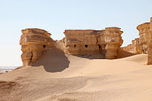
The landscape is similar to that of el-Baḥrein, only the lakes are smaller here. The landscape is characterized by two lakes with reed vegetation. To the south of the lakes there are sand dunes, in the northwest of the western lake there is a flat sandstone hill, which reaches up to 200 meters to the shore of the lake, with several silted up graves. The western lake is fed by a spring, the eastern lake has no spring.
Especially in the 1 small area(28 ° 42 '38 "N.26 ° 43 '36 "E.), in which the sandstone rock in the northwest of the western lake approaches, numerous graves were dug. These are both ground-level burials, but also burials that were laid so high in the rock that the corpses could not be eaten by animals. The graves consist of simple deep tunnels. The deeper graves were occasionally walled up.

The buried are probably participants in caravans who died during the expedition. This indicates that the type of burial corresponds to ancient Egyptian or Hellenistic customs, but not that of Bedouins.


Therefore, no elaborate burial could take place. The dead were not mummified. For burial, the deceased were placed on a stretcher made of palm panicles and bandages, or they were wrapped together with the panicles, which then also served as struts. Death masks or a regular cult of the dead were dispensed with.
Kitchen and accommodation
Food and drinks must be brought along. Leftovers shouldn't be left behind.
At some distance from the lakes you could sleep in tents you brought with you. Mosquitos must be expected on the lake itself. A possible overnight stay must be part of the permit for travel along the route Darb Siwa be by the Egyptian military.
literature
- : Notes on the Baḥrēn, Nuwemisah, and el-Aʿreg Oases in the Libyan Dessert. In:Journal of Egyptian Archeology (JEA), ISSN0075-4234, Vol.23 (1937), P. 227, plates XXII, XXIII.1,2 (entire article p. 226–229).
- : The Ammoneion: Archeology, History and Cult Practice of the Oracle of Siwa. Mainz: from Zabern, 1988, Archaeological publications; 75, ISBN 978-3-8053-0819-9 , P. 89 f., Plate 43.b.
Individual evidence
- ↑: Obituary: Wilfrid Jennings Bramly, M. B. E., M. C. In:The Geographical Journal (GJ), ISSN0016-7398, Vol.126,2 (1960), Pp. 258–259, doi:10.2307/1794038.
