 Tiran Island and the Strait of Tiran | ||
| Gulf of Aqaba · خليج العقبة | ||
| length | 177 km | |
|---|---|---|
| width | 27 km | |
| depth | 1829 m | |
| location | ||
| ||

The Gulf of Aqaba or Gulf of Aqaba, Arabic:خليج العقبة, Chalīǧ al-ʿAqaba, „the Gulf of al-ʿAqaba“, Is an elongated bay 190 kilometers long and a natural waterway that runs along the northern edge of the Red sea begins and the Sinai of the Arabian Peninsula separates. In Israel is also the name Gulf of Eilat, מיפרץ אילת, Mifraz Eilat, common. The Gulf of Aqaba is part of the Great African rift valley, which runs into the Jordan Valley. There are extensive holiday resorts and diving areas in particular on its west side and in the north.
background

The Gulf of Aqaba is one of the most important bathing and diving areas in the world, located in both Egypt and Israel.
Similar to the Gulf of Suez the Gulf of Aqaba is part of a rift valley. But there are big differences between the two bays. The Gulf of Aqaba is 177 kilometers long and between 19 and 27 kilometers wide. But the Gulf of Aqaba is considerably deeper than the Gulf of Suez. The deepest point to date, at 1,829 meters, was found in early 1935 by the Egyptian expedition with the research vessel Mabahiss, roughly in the middle of the Gulf near the east coast.[1] In the south of the Gulf of Aqaba is the Strait of Tīrān, a strait only about 13 kilometers wide.
Neighboring countries are clockwise Egypt with the peninsula Sinai, Israel with the city Eilat, Jordan with the city that gave it its name Aqaba and Saudi Arabia. For Jordan and Israel in particular, the Gulf of Aqaba is the shortest route to the Indian Ocean about the Red Sea.
The Gulf of Aqaba is not counted as part of the Red Sea. The southern boundary of the gulf is by definition along the line from the cape Raʾs al-Qaṣba in Saudi Arabia, Arabic:رأس القصبة, At 1 28 ° 1 '18 "N.34 ° 37 '55 "E, also Raʾs el-Faṣma, رأس الفصمة, Called, in a south-westerly direction to 1 Requin Island(27 ° 58 ′ 5 ″ N.34 ° 35 ′ 27 ″ E). The line now runs in a south-southwest direction across the island 2 Tīrān to their southwest point 2 27 ° 54 ′ 41 ″ N.34 ° 33 ′ 20 ″ E and about 1.25 kilometers further south to the lower reef foot of the island of Tīrān. From now on, it continues in a westerly direction at latitude 27 ° 54 ′ north to the Sinai peninsula in the area of the Multinational Force and Observers Camp south of the Naʿama Bay.[2]
The northernmost point of the Gulf of Aqaba forms the 1 Central Beach(29 ° 32 '59 "N.34 ° 57 ′ 19 ″ E) in Eilat south of the Astral Seaside Hotel.
In many places the Gulf of Aqaba merges almost directly into the coastal mountains. If there are coastal strips, they are usually very narrow. Initially, the pool gradually descends to a depth of 500 meters, then abruptly drops to 1000 meters and deeper. The basin consists of at least two depressions: the northern one is around 1,100 meters deep, the southern over 1,400 meters. A natural bank separates the Gulf of Aqaba in the area of the Strait of Tīrān from the Red Sea.[3]
There are two main currents in the Gulf of Aqaba: the surface current brings water from the Red Sea into the Gulf, the deep current runs in the opposite direction. The water temperature drops from the surface to a depth of 300–400 meters and still reaches values of around 21 ° C. At greater depths, the temperature increases again slightly.[1]
places


In Egypt
- 1 Ṭābā - Border town.
- 2 Taba Heights - Resort south of Taba.
- 3 Nuweiba - resort.
- 4 Dahab - resort.
- 5 Sharm esch-Sheikh - The most famous resort of Sinai.
.JPG/320px-Flag_Plaza_(Taba,_Egypt).JPG)


In Israel
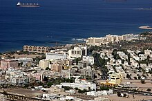
- 6 Eilat

In Jordan
- 7 Aqaba

In Saudi Arabia
Other goals
- 3 Gazīrat Firʿaun (Pharaoh Island) - Sultan's fortress Saladin (1137/1138–1193)
- 4 Qalʿat Zamān - medieval citadel between Nuweiba and Taba Heights.
- 5 Nabq nature reserve North of Sharm esch-Sheikh


There are extensive reef diving areas near the coast, which are suitable for both snorkelers and divers.

getting there
In the street
The coastal towns on the Sinai can be reached via paved coastal roads. There are also public buses from here Cairo or from different places on Sinai.
By boat
Divers reach the Gulf of Aqaba with motor yachts from the coastal towns. There are both day trips and liveaboards.
By plane
The cheapest connection is provided by the 3 Sharm el-Sheikh International Airport![]()
![]()
![]()
![]() (IATA: SSH) and the 4 Taba International Airport
(IATA: SSH) and the 4 Taba International Airport![]()
![]() (IATA: TCP).
(IATA: TCP).

mobility
security
climate
Climate on the coast
The climate is warm and humid, which results from the high temperatures of the adjacent desert areas and the high evaporation rate of the Red Sea.
| Dahab | Jan | Feb | March | Apr | May | Jun | Jul | Aug | Sep | Oct | Nov | Dec | ||
|---|---|---|---|---|---|---|---|---|---|---|---|---|---|---|
| Mean highest air temperature in ° C | 20 | 21 | 24 | 28 | 32 | 35 | 38 | 40 | 34 | 31 | 27 | 21 | O | 29.3 |
| Mean lowest air temperature in ° C | 8 | 8 | 10 | 14 | 19 | 21 | 24 | 24 | 23 | 20 | 15 | 9 | O | 16.3 |
| Average water temperature in ° C | 19 | 20 | 20 | 21 | 23 | 25 | 29 | 29 | 28 | 25 | 23 | 19 | O | 23.4 |
| Relative humidity in% | 59 | 59 | 59 | 61 | 68 | 68 | 68 | 68 | 65 | 60 | 59 | 59 | O | 62.8 |
Waters of the Gulf of Aqaba
The water temperatures are between 19 ° C and 29 ° C, depending on the season, this temperature is also available at greater depths of around 30 meters. Currents can also bring colder water with them. The salt content is very high at 4.1%.
Individual evidence
- ↑ 1,01,1: The Egyptian expedition to the Red Sea 1934/35. In:Deep Sea Research / Part A: Oceanographic Research Papers, ISSN0198-0149, Vol.31,6–8 (1984), Pp. 599-616, especially p. 600, doi:10.1016 / 0198-0149 (84) 90030-X. - A detailed documentation of the Mabahiss / Mabahith expedition can be found in: : Physical and Chemical Oceanography of the Red Sea. In:Oceanography and marine biology: an annual review, ISSN0078-3218, Vol.8 (1970), Pp. 73-202.
- ↑: Limits of Oceans and Seas. Monte Carlo: Monégasque, 1953 (3rd edition), Special publication; 23, P. 19; PDF.
- ↑: The Red Sea and the Gulf of Aden. The Hague [and others]: Nijhoff, 1982, International straits of the world / Center for the Study of Marine Policy, The University of Delaware; 5, ISBN 978-90-247-2501-4 , P. 4.
