 Suez Canal north of Ismailia | ||
| Suez Canal · قناة السويس | ||
| length | 163 km, with access canals 193 km | |
|---|---|---|
| location | ||
| ||

The Suez Canal or Suez Canal (Arabic:قناة السويس, Qanāt as-Suwais) lies between the northern part of the mainland block Egypt and the Sinai-Peninsula. The artificial waterway, at the ends of which are important port cities, connects them Mediterranean Sea with the Red sea and is 163 km long.
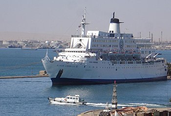
places


.JPG/350px-Port_said_egypt_(5).JPG)
- 3 Port Fuad


 in the Wikidata database") - Sister city of Port Said.
- Sister city of Port Said.

- 4 Sue - port city on Gulf of Suez and capital of the governorate Sue.
Other goals
- 5 Fayid - Resort south of Ismailia

With the construction of the Suez Canal, some existing lakes received an increased supply of water from the Gulf of Suez:
- 1 Timsāḥ lake(30 ° 34 '40 "N.32 ° 17 ′ 20 ″ E), Arabic:بحيرة التمساح, Buhairat at-Timsāḥ, „Crocodile lake"). The former shallow brackish water lake is located in the southeast of the city of Ismailia and offers a number of beaches on its west bank.

- 2 Great bitter lake and Kleiner Bitteree south of Ismailia.
.JPG/350px-Great_Bitter_Lake_from_space_(hires).JPG)
- 3 Manzala lake west of Port Said.

background
Importance of the channel
The Suez Canal is an artificially created waterway in Egypt in the 19th century that connects the Mediterranean Sea via the isthmus (isthmus) of Suez with the Gulf of Suez connects. The canal enables significantly shorter ship journeys between the North Atlantic and the Middle East and Asia, because it saves having to bypass Africa. The canal is about 163 kilometers long (193 kilometers with access canals) and has no locks. In 2009 the canal was deepened again - its draft is now 20.1 meters - so that almost all bulk carriers and container ships and two thirds of all tankers can pass through it fully loaded. Since the expansion in 2014/2015, the canal can be used on two lanes over a length of 115 kilometers. Bypasses are used for this purpose. B. in the area of the Great Bitter Lakes and a newly created sub-channel.
The administration of the Suez Canal, the Suez Canal Authority, located in Ismailia. The income from the user fees for the Suez Canal represent the most important source of income in Egypt alongside tourism. In 2008 the Suez Canal Authority achieved a revenue of 5.38 billion US dollars. That is about a sixth of all foreign exchange income in Egypt.
Ancient channel between the Nile and the Gulf of Suez


Before the Suez Canal was built, there was never a previous building. However, a canal led from the Nile Delta to the present day in ancient times Sue. He started with Bubastis at today's ez-Zaqāzīq and led through the Wādī eṭ-Ṭumīlāt past the archaeological site of 4 Tell el-Masc̲h̲ūṭa![]()
![]() (presumably the ancient pithom / Heroonpolis) over the Timsāḥ lake and the bitter lakes to the Gulf of Suez at today's Suez. A first freshwater canal into the Wādī eṭ-Ṭumīlāt to supply cities east of the Nile Delta was probably built as early as the 19th dynasty.[1]
(presumably the ancient pithom / Heroonpolis) over the Timsāḥ lake and the bitter lakes to the Gulf of Suez at today's Suez. A first freshwater canal into the Wādī eṭ-Ṭumīlāt to supply cities east of the Nile Delta was probably built as early as the 19th dynasty.[1]
Various Greek historians reported on construction work on this canal.[2] The canal project was under Necho II., the second king of the 26th ancient Egyptian dynasty (reign 610-595 BC), resumed, probably without completing him. Under the Persian great king Darius I. "The great" from the 27th dynasty (reign 522–486 BC) the canal was exposed again. The canal is said to have been 45 meters wide and about 5 meters deep. A renewed exposure took place below Ptolemy II Philadelphus (Greek period, reign 285–246 BC) around 270/269 BC. In the area of Suez Ptolemy II had the canal closed with a lock, which was supposed to prevent the salt water of the Red Sea from entering the canal in excessively large quantities.
The canal was again under the Roman emperor Hadrian (Reigns 117-138) exposed. Under the Arab general ʿAmr ibn el-ʿĀṣ (around 580–664) it was repaired for the last time and led to after Cairo. The canal has not been usable since the 8th century. Around 754/755 the canal is said to be under the caliph el-Manṣūr ibn Muḥammad have been filled in to prevent its use by the army of Muḥammad ibn Abū Ṭālib.
Parts of the canal were still visible in 1799.[3]
The modern freshwater canal, the Ismailiya Canal, to supply the population in the cities on the Suez Canal, largely follows the ancient canal.
History of the Suez Canal


As early as 1504, Venetian merchants suggested that the Ottomans build a canal at this point. Measurements during the Egyptian Napoleon expedition of 1799 gave the wrong result that the Red Sea was about 9.91 meters higher than the Mediterranean. 1830 was by the British Francis Rawdon Chesney (1789–1872) corrected the mistake, but his feasibility study was ignored. So it was not until 1846 through measurements by the Société d’Études du Canal de Suez a possible construction initiated.
The construction of the canal is a bit random. The French diplomat Ferdinand de Lesseps (1805-1894) was just able to appoint the Egyptian viceroy Muhammad Said Pasha (Reign 1854–1863), whom he knew from his youth, convinced of the construction of the Suez Canal and in 1854 also received the concession to found a canal company. However, British diplomats tried to prevent or delay the construction of the canal. In 1858 Lesseps founded the Compagnie universelle du canal maritime de Suezwhose share capital of 200 million francs consisted of 56% sales of shares, mainly by French investors, the rest of which was contributed by the Egyptian viceroy. The canal was to be managed by the company for 99 years.
On April 25, 1859, work began on the Mediterranean Sea at a location that was later named after the viceroy Port Said should be without a building permit. The work was not easy because the canal crosses a desert. All materials had to be brought in by camel transports, later via rail connections created for this purpose. Up to 1.5 million Egyptians were involved in the construction work. In the end, the construction costs amounted to 426 million francs. Seven years after the start of construction, on March 19, 1866, the final building permit was granted by the High Gate in Constantinople, which is today Istanbul, granted.
On November 17, 1869, after a good ten years of construction, the canal was opened as part of three-day festivities in the presence of around 6,000 European and 25,000 Egyptian guests. A big fireworks display took place the day before. On November 17, a convoy of ships reached Ismailia by the yacht Aigle the empress Eugénie de Montijo (1826–1920), on which Lesseps was also located. The remaining work, such as deepening the canal, was completed on April 15, 1871. A few days before the opening of the Suez Canal, on November 1st, 1869, the Khedivian Opera House in Cairo opened with Verdi's opera Rigoletto opened. Verdis Aida was not intended for the opening of the Suez Canal, it was premiered in this opera house on December 24, 1871.
During the canal construction was with Ismailia another city newly laid out, in which the seat of the Suez Canal Society was located. The city was named after the viceroy Ismail Pasha (Reign 1863–1879), who followed Muhammad Said Pasha in office.

In the beginning the income amounted to only about 4 million francs a year. Since Egypt was insolvent, the British government took over the Egyptians' share in 1875 and was able to secure a decisive influence. On October 29, 1888, the canal was through the Constantinople Convention to the neutral zone, which provided free passage for all ships even in times of war. Even after the formation of the Kingdom of Egypt in 1922, the canal was controlled by Great Britain and again contractually secured in 1936. The Constantinople Convention was confirmed again by the Egyptian government on April 24, 1952.
Twelve years before the concession expired, the Suez Canal became under the Egyptian President on July 26, 1956 Gamal Abd el-Nasser (Reign 1954–1970) nationalized. In the Suez crisis that followed[4] British, French and Israeli forces attacked Egypt on October 29, 1956. After intervention by the USA, the USSR and the UN, the fighting ceased on December 22, 1956. In the following years the sunken ships were lifted, so that on April 10, 1957 with that of the Italian Oceania the first ship passed the canal.
In the 1967 Six Day War, Israeli forces captured Sinai and advanced as far as the Suez Canal, which now formed the border between Egypt and Israel and was closed to shipping. On October 6, 1973, at the beginning of the Yom Kippur War, Egyptian troops managed to overcome the canal and the Israeli defense line on the Suez Canal, the Bar Lew Line. Ten days later, however, the canal was recaptured by Israeli forces. In the following ceasefire negotiations, it was possible to achieve that Israeli troops withdrew to the Sinai, and the canal came back under Egyptian control. The canal reopened in 1975.
The Suez Canal was expanded in 2014/2015 at a cost of around 8 billion dollars. A second fairway with a length of 35 kilometers was dug between the Ballah Bypass north of the el-Firdān railway bridge and the Great Bitter Lake, and the canal was widened and deepened for a further 37 kilometers. Over 80 domestic and foreign companies under the leadership of the Egyptian armed forces were involved in the construction work on the “New Suez Canal”. With the expansion, it is now possible for ships to pass the canal over a length of 115 kilometers in both directions. The test run with six ships took place on July 26, 2015.[5]
The expanded canal officially opened on August 6, 2015. The Egyptian President, ʿAbd el-Fattāḥ es-Sīsī, traveled to the celebrations on the presidential yacht Mahroussa , Arabic:المحروسة, al-Maḥrūsa, „the one protected by God", at.[6] This yacht was not chosen by chance. The 146 meters long, of the Samuda Brothers The former royal yacht of Viceroy Ismail Pasha, built in London in 1865, was the first ship to cross the Suez Canal in 1869. Ismail Pasha reached Port Said on November 13, 1869 to receive his guests there.[7]
After the expansion, 97 instead of 49 ships can now pass the canal every day. The passage now takes about eleven hours without breaks compared to the previous 16 hours.
Ismailiya Canal
In order to supply the population of Ismailia, Port Said and Suez, a freshwater channel was built from the Nile in parallel to the construction of the Suez Canal in 1859 - the Ismailiya Canal. He starts at Cairo, cross that Wādī eṭ-Ṭumīlāt and arrives at Ismailia, where it was completed in 1862. Here it branches off and continues as a canal to Suez (1863) and as a water pipe to Port Said (1864). The polluted water serves as a drinking water supply for the population of the cities mentioned.
getting there

By train
The Suez Canal Cities Sue, Ismailia and Port Said are out with trains Cairo reachable.
By bus
The Suez Canal cities of Suez, Ismailia and Port Said can be reached by buses from Cairo. There are bus connections from Suez Hurghada and in the South Sinai.
mobility


Along the canal there is 14 Ferry connections. This includes the 1 Ferry 6(30 ° 35 '24 "N.32 ° 18 ′ 33 ″ E) six kilometers north of Ismailia.

At 6 el-Qanṭara![]()
![]()
![]() became the 2 Peace Bridge
became the 2 Peace Bridge![]()
![]()
![]() (30 ° 49 '42 "N.32 ° 19 ′ 1 ″ E) (also Egyptian-Japanese Friendship Bridge called, Arabic:كوبري السلام, Kūbrī as-Salām, completed, which serves as a road bridge. 12 kilometers north of Ismailia was with the 3 el-Firdān railway bridge
(30 ° 49 '42 "N.32 ° 19 ′ 1 ″ E) (also Egyptian-Japanese Friendship Bridge called, Arabic:كوبري السلام, Kūbrī as-Salām, completed, which serves as a road bridge. 12 kilometers north of Ismailia was with the 3 el-Firdān railway bridge![]()
![]()
![]() (30 ° 39 '26 "N.32 ° 20 ′ 1 ″ E), Arabic:كوبري الفردان, Kūbrī al-Firdān, a combined railway and road swing bridge, which was also reopened in 2001 because the previous building was destroyed in the Six Day War in 1967. The bridge has now been dismantled and is to be rebuilt at a suitable location on the Nile. The bridge will be replaced by ferries and a new tunnel.
(30 ° 39 '26 "N.32 ° 20 ′ 1 ″ E), Arabic:كوبري الفردان, Kūbrī al-Firdān, a combined railway and road swing bridge, which was also reopened in 2001 because the previous building was destroyed in the Six Day War in 1967. The bridge has now been dismantled and is to be rebuilt at a suitable location on the Nile. The bridge will be replaced by ferries and a new tunnel.


13 kilometers north of Sue passes under the 1.7 kilometers long 4 Aḥmad-Ḥamdī tunnel![]()
![]()
![]() (30 ° 5 '32 "N.32 ° 34 '16 "E), Arabic:نفق الشهيد أحمد حمدي, Nafaq al-Shahid Aḥmad Ḥamdī, „Martyrs Aḥmad Ḥamdī tunnel“, The Suez Canal. The tunnel, named after the Egyptian general Aḥmad Ḥamdī, who fell while crossing the Suez Canal in the Yom Kippur War, was completed in 1983, but it was leaky and had to be renovated between 1992 and 1995 with Japanese support.
(30 ° 5 '32 "N.32 ° 34 '16 "E), Arabic:نفق الشهيد أحمد حمدي, Nafaq al-Shahid Aḥmad Ḥamdī, „Martyrs Aḥmad Ḥamdī tunnel“, The Suez Canal. The tunnel, named after the Egyptian general Aḥmad Ḥamdī, who fell while crossing the Suez Canal in the Yom Kippur War, was completed in 1983, but it was leaky and had to be renovated between 1992 and 1995 with Japanese support.

Tourist Attractions
activities
security
trips
literature
- : Creation of the Suez Canal. Dusseldorf: VDI, 1991, Classic of technology, ISBN 978-3184006426 . Reprint of the Berlin 1888 edition.
- : Canal, Nile – Red Sea. In:Helck, Wolfgang; Westendorf, Wolfhart (Ed.): Lexicon of Egyptology; Vol. 3: Horhekenu - Megeb. Wiesbaden: Harrassowitz, 1980, ISBN 978-3-447-02100-5 , Col. 312 f.
- History of the Suez Canal, Article of the German language Wikipedia.
Individual evidence
- ↑: Tell el-Dabʿa; 2: The place of discovery as part of an archaeological-geographical investigation over the Egyptian eastern delta. Vienna: Publishing house of the Austrian Academy of Sciences, 1975, Memoranda of the whole academy / Austrian academy of sciences; 4th, ISBN 978-3700101369 , P. 88 ff.
- ↑Diodorus, history, 1st book, § 33; Herodotus, Histories, 2nd book, § 185; Pliny the Younger, Natural history, 6th book, § 29; Strabo, geography; Ptolemy, geography, 4th book, § 5.
- ↑: Anciens canaux, anciens sites et ports de Suez. Le Caire: Société Royale de Géographie d'Égypte, 1925, Mémoires / Société Royale de Géographie d’Égypte; 7th, Pp. 105 ff., 109 ff.
- ↑: Suez. London: Weidenfeld and Nicolson, 1991, ISBN 978-0297811626 . Suez crisis.
- ↑AFP: First ships pass the enlarged Suez Canal, News on Zeit Online from July 26, 2015.
- ↑dpa: Sisi celebrates its prestige project, Message on Spiegel Online from August 6, 2015.
- ↑Sherif Aref: Memories of the Mahroussa, Report on Al-Ahram Weekly, Aug. 6, 2015.
