 Nile Delta from the air | |
| Nile Delta · دلتا النيل | |
| surface | about 24,000 km² |
|---|---|
| length | 160 km |
| Coastline | 240 km |
The Nile Delta (Arabic:دلتا النيل, Diltā an-Nīl), the approximately 24,000 square kilometers large delta of the Nils, located in the north Egypt and forms the main part Lower Egypt. It starts north of Cairo and is used by the Mediterranean coast limited to the north.
places

 1 Alexandria - Mediterranean metropolis and second largest city in Egypt

- 2 Banhā - Capital of the governorate el-Qalyūbīya

- 3 Bilbeis - City in the place of the ancient Phelbs


- 5 Damanhūr - Capital of the governorate el-Buḥeira

- 6 Kafr esch-Sheikh - Capital of the governorate Kafr esch-Sheikh
- 7 el-Maḥalla el-Kubrā - Industrial city in the governorate el-Gharbīya

- 8 el-Manṣūra - Capital of the governorate ed-Daqahlīya

- 9 Rashid (Rosetta) - port city east of Alexandria with charming town houses from the 16th to 19th centuries

- 10 Ṭanṭā - Capital of the governorate el-Gharbīya, important Muslim pilgrimage town in the vicinity of the Badawi Mosque

- 11 Samannūd (Sebennytos) - small town in the place of the ancient Sebennytos with several Muslim buildings and the Church of St. Abā Nūb

- 12 Shibin el-Hardly - Capital of the governorate el-Minūfīya

- 13 Schubrā el-Cheima - Industrial city in the north of Cairo. In the area of the Agricultural University of 'Ain Shams University is the Muhammad Ali's summer palace.
- 14 ez-Zaqāzīq (ez-zagazig) - capital of the governorate esch-Sharqīya. In the southeast of the city is the archaeological site Tell Basṭa.

Other goals
Lakes near the coast
On the coast there are three large lagoons in the area of the Nile Delta:
- 15 Manzala lake - shallow salt lake north of Ṣān el-Ḥagar el-Qiblīya and west of Port Saidsuitable for bird watching.
- 16 Burullus lake (Arabic:بحيرة البرلس, Buḥeirat al-Burullus) - brackish lake west of Rashid
- 17 Idku lake (Arabic:بحيرة إدكو, Buḥeirat Idkū) - Brackish lake between Abū Qīr and Rashīd
Western delta

- 18 Abū Qīr - City in the place of the ancient Canopus

- 19 Sacha, the ancient Egyptian Xois - Village with the Church of St. Virgin Mary.

- 20 Tell el-Farāʿīn, the ancient Egyptian Buto - archaeological site

- 21 Mouth of the Rosetta arm of the Nile in the Mediterranean

Central delta
- 22 Abū Ṣīr Banā, the ancient Egyptian Busiris - Village and archaeological site
- 23 Bahbīt el-Ḥigāra - Village and archaeological site (Per-Hebitet, Iseum)

- 24 Barrage du Nile (Delta Barrage) - Dam in the north of Cairo
- 25 Sunbāṭ - Village with the Church of St. Rebekah

- 26 Ziftā - City with a dam
Eastern delta
- 27 DaqādūsDaqadus - village, church of St. Virgin Mary.

- 28 Deir el-Qiddīsa Damyāna - Monastery of St. Damiana and the 40 virgins

- 29 Mīt Damsīs - village, monastery of St. George.

- 30 Qantīr, the ancient Egyptian Pi-ramesse - archaeological site
- 31 Raʾs el-Barr - Mediterranean vacation spot

- 32 Ṣān el-Ḥagar el-Qiblīya, the ancient Egyptian Tanis - Village and archaeological site

- 33 Tell Basṭa, the ancient Egyptian Bubastis - archaeological site

- 34 Tell eḍ-Ḍabʿa, the ancient Egyptian Avaris - archaeological site
- 35 Tell er-Rubʿ, the ancient Egyptian Mendes - archaeological site.

- 36 Mouth of the Damietta arm of the Nile in the Mediterranean
Additional goals are set out in the articles on the individual governorates (Alexandria, el-Buḥeira, ed-Daqahlīya, Dumyāṭ, el-Gharbīya, Kafr esch-Sheikh, el-Minūfīya, el-Qalyūbīya and esch-Sharqīya) listed.
Routes
- The Route agricole connects in the western delta Cairo With Alexandria, but runs through the Nile Delta and not through the desert.
- Parts of the Escape route of the Holy Family to Egypt are located in the Nile Delta.
background
Landscape of the Nile Delta
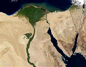
The Nile Delta is the mouth of the Nils at the egyptian Coast of Mediterranean. The delta is fan-shaped, roughly in the shape of an inverted delta ∇ and, with an area of 24,000 square kilometers, is one of the largest river deltas in the world. The delta begins about 16 kilometers north of Cairo at Qanatir el-Cheirat and has only a slight gradient of twenty meters to the Mediterranean. Today there are only two estuary arms left in this delta, the Damiette and Rosetta arms. The delta is still crossed by numerous artificially created canals. The land is flat, and the few hills called Tell or Kōm are the remains of earlier, ancient Egyptian and Greco-Roman settlements.
The name delta for this area, but only for the Nile Delta, already existed among the Ionianson which the historian Herodotus (490/480 to 424 BC) in his Histories Refers.[1] The term was borrowed from the letter Delt (Daleth) ![]() in the Phoenician scriptwhere he got the meaning door and it entered the Greek alphabet around the middle of the ninth century BC. As a technical term for all such estuaries it is only used by the historian Arrian (85–90 to after 145/146 AD) by adding in his Indica and in the Alexander story compared the rivers Nile, Hindus and Danube.[2] A delta is created by a low flow velocity in the river, so that sediments can be deposited. At some point it happens that the river has to flow around its own deposits and shifts or forks. The deposits also meant that the Nile Delta pushed further and further into the Mediterranean.
in the Phoenician scriptwhere he got the meaning door and it entered the Greek alphabet around the middle of the ninth century BC. As a technical term for all such estuaries it is only used by the historian Arrian (85–90 to after 145/146 AD) by adding in his Indica and in the Alexander story compared the rivers Nile, Hindus and Danube.[2] A delta is created by a low flow velocity in the river, so that sediments can be deposited. At some point it happens that the river has to flow around its own deposits and shifts or forks. The deposits also meant that the Nile Delta pushed further and further into the Mediterranean.
In Roman times there were still seven mouth arms counted, in the Middle Ages five. In Islamic times three other arms, the Sebennytic, the Bucolic and the Phatnian arm, silted up. In the past there were also numerous lakes and swamps in the delta.
The damming of the Nile since the beginning of the 20th century led and is now leading to drastic changes because hardly any sediments are added. As a result, the delta not only no longer enlarges, but is even eroded by the sea surf. As a result of global warming, sea levels are also rising, flooding the coastal areas and becoming increasingly saline.
Nevertheless, the delta is still one of the most fertile areas in Egypt today, and its area is twice as large as the strip of fruit land in the Nile Valley. It is a refuge for numerous species of fish, reptiles, birds and mammals. These include turtles, ducks, ibises, cormorants, seagulls, plovers, herons, and swallows Mongooses. Crocodiles and hippos are already extinct. The last hippopotamus was shot in 1815.
History of the Nile Delta
It is therefore not surprising that the Nile Delta has been used continuously since predynastic times because of its fertility. The oldest testimonies were in Buto, today's Tell el-Farāʿīn, uncovered by German archaeologists. There has been evidence here since the first half of the fourth century, from around 3,200 BC. Until the end of the Old Kingdom, around 2200 BC. Chr.[3] The Nile Delta gained greater importance in the Second Intermediate Period, around 1650–1550 BC. When the so-called Hyksos princes of Avaris from over Lower Egypt ruled. The presence even increased under the Ramessid kings in the 19th and early 20th dynasties. Testimonies such as the tombs and temples of Tanis date from the Third Intermediate Period, around 1070–664 BC. Lasted. But temples were built and used until the Greco-Roman times.
The Nile Delta was also important in the Middle Ages: the delta and its river arms repeatedly served as gateways to Egypt. B. at the time of the Crusaders.
Despite the long history, only a few testimonies have survived today, which are mostly only accessible to enthusiasts, Egyptologists or archaeologists. Buildings made from less durable materials such as clay and wood have been washed away and destroyed by floods and rains, and farmers use the nutrient-rich clay from the old settlements, the Sibachto fertilize their fields. Statues and building fragments were often abducted and reused elsewhere. Due to the poor preservation, but also the more difficult excavation conditions, there are only a few excavations and restorations in the Nile Delta compared to the Nile Valley.
Todays use
The Nile Delta is still predominant today agricultural used. As I said, its area is twice as large as the agriculturally usable area of the Nile Valley, or in other words, two thirds of the agricultural area of Egypt is located here. A large part of the Egyptian population lives here, in the eight governorates, excluding Alexandria and Port Said, in 2006 around 42 percent of the Egyptians.[4] Around 70 percent of the population live in rural areas, and a third of them also work in agriculture. The strong population growth in both the cities and villages, around two percent per year, means that the area under cultivation is steadily decreasing. For this reason, attempts have been made since the middle of the 20th century to counteract population growth by draining the coastal lagoons and reclaiming new land in the deserts in the east and west of the delta. The land gain is only about 15 percent, and the areas are of poor quality. There is insufficient irrigation water in the new land areas, and the coastal areas are becoming too salty and watery. This of course leads to lower quality fruits and vegetables.
Cotton is still one of the most important products: Good quality West Indian cotton (Gossypium barbadense) grown. This agricultural focus has its origins in the British occupation. Great Britain needed as a result of the Civil War in the southern states of the USA, 1861–1865, alternative sources of supply for cotton, which were now grown in Egypt and British India. The cotton seeds obtained by gutting are also used to produce vegetable oil, which is mainly used in the soap industry.
In terms of cotton production, the Linen weaving, the largest industry in the Nile Delta. Around three million cloths are produced annually on the approximately 30,000 looms and some are exported. But the competition from Southeast Asia is now also causing problems for the Egyptians with their cheap textile imports.
Fish farming and fishing is mainly operated in farms in the lagoons, Lake Burullus and Lake Manzala, while sea fishing only plays a subordinate role. Around 15 percent of all Egyptian fish catches are produced in the Nile Delta. But there are also problems here: due to water pollution from industrial and municipal wastewater, the fish are of poor quality.
The port operations, which were relocated from Raschīd to Alexandria in the 19th century, are only slowly returning to the delta. So in Dumyāṭ a port for container ships created to relieve the port of Alexandria. In the same city, with the establishment of furniture production, the craft were relied on.
The tourism, almost exclusively domestic tourism, only plays a subordinate role. There is recreational tourism z. B. in Raʾs el-Barr and Balṭīm with around 400,000 Egyptian tourists annually and, to a greater extent, Coptic-Christian and Islamic pilgrimage tourism, e.g. B. after Mīt Damsīs, Deir el-Qiddīsa Damyāna and Ṭanṭā. The tourist infrastructure for transport, accommodation, food and entertainment is, however, only on a low level.
getting there
By train
The railway network is well developed in the delta. The main routes lead from Cairo above Ṭanṭā to Alexandria as well as from Cairo above Ṭanṭā, ez-Zaqāzīq and el-Manṣūra to Dumyāṭ. There are other branch lines, which are common in Ṭanṭā and Banhā start. Express trains also run on the main routes, which of course only stop in the big cities.
In the street
Of course, the destinations can also be reached by car or taxi. Taking a taxi is not so absurd, because the drivers know the way and the oversized bumps to calm the traffic, but also the dangers of village life with children and animals on the streets. And can they help with problems.
By bus
Long-distance buses run between Cairo and the governorate capitals and between the latter cities. Microbuses and service taxis also run at shorter intervals.
Important bus stations in Cairo are ʿAbūd in the Schubra district and near the Schubra el-Cheima metro station.
By plane
There are only airports in Alexandria (1 Borg El Arab![]()
![]()
![]() (IATA: HBE)) and in 2 Cairo
(IATA: HBE)) and in 2 Cairo![]()
![]()
![]()
![]() (IATA: CAI).
(IATA: CAI).


mobility
Microbuses and service taxis form the backbone of local public transport to the surrounding villages.
Tourist Attractions
There are a number of significant ones in the Nile Delta Cities with their religious buildings such as mosques and churches as well as markets, which present themselves as real Egyptian cities far away from tourism. A number of buildings dating from the colonial era, such as palaces, residential and commercial buildings, date from the second half of the 19th and first half of the 20th century.
Even if to a small extent, there are easily accessible ones archaeological sites how Tell Basṭa, the former Bubastis, and Ṣān el-Ḥagar el-Qiblīya, the former Tanis.
Scenic the Nile Delta differs significantly from the Nile Valley. You can get to the bottom of it with a taxi or third-class trains. The trains go slowly, windows are often missing or doors are open, which is particularly useful for photographers. The coastal regions with the large lagoons and the mouths of the two branches of the Nile into the Mediterranean Sea are certainly of particular charm.
activities
The shallow lagoons are a paradise for Ornithologistswho can watch birds migrating and hibernating in the winter months.
Across the country they are carried out in the Nile Delta Holy feasts, the Mūlids, known. Literally, these are birthday celebrations, but mainly saints of the major religions are worshiped here. The most important Islamic mulid is that for the Sufi mystic Saiyid Aḥmad el-Badawī in Ṭanṭā with well over a million visitors. This is where people trade and play music, and Sufis conduct their intense prayer rituals, the Dhikrs, by. In Disūq becomes the festival of saints in honor of the Sufi saint Ibrāhīm ed-Disūqī carried out, in Fuwwa the des Abū el-Mukārim. Christians break out on pilgrimages z. B. in the Church of St. George in Mīt Damsīs or ins Monastery of St. Damyāna on. At Damanhūr also becomes the Moroccan rabbi Abu Hatzeira adored. Approval for the festival of Abu Hatzeira has been repeatedly refused by the state in recent years.
security
There is hardly any general crime in the cities and villages.
There are also demonstrations and riots in the industrial centers, which should be avoided. Attacks against police stations must be expected.
Bathing in the river arms and canals should be avoided as there is a risk of Schistosomiasis (Schistosomiasis).
climate
The Nile Delta has a mild climate all year round. From October to March, mainly in January, rain and storms can be expected on the Mediterranean coast.
| Aunt | Jan | Feb | March | Apr | May | Jun | Jul | Aug | Sep | Oct | Nov | Dec | ||
|---|---|---|---|---|---|---|---|---|---|---|---|---|---|---|
| Mean highest air temperature in ° C | 19 | 19 | 22 | 27 | 31 | 34 | 33 | 33 | 32 | 29 | 24 | 20 | O | 26.9 |
| Average air temperature in ° C | 12 | 13 | 14 | 18 | 22 | 25 | 26 | 26 | 24 | 22 | 18 | 14 | O | 19.5 |
| Mean lowest air temperature in ° C | 6 | 7 | 8 | 11 | 14 | 17 | 20 | 20 | 18 | 15 | 12 | 8 | O | 13 |
| Precipitation in mm | 13 | 8 | 7 | 3 | 2 | 0 | 0 | 0 | 0 | 2 | 4 | 12 | Σ | 51 |
Tanta, Egypt: Climate, Global Warming, and Daylight Charts and Data, accessed November 17, 2009. | ||||||||||||||
| Port Said, El Gamil | Jan | Feb | March | Apr | May | Jun | Jul | Aug | Sep | Oct | Nov | Dec | ||
|---|---|---|---|---|---|---|---|---|---|---|---|---|---|---|
| Mean highest air temperature in ° C | 17 | 18 | 19 | 22 | 25 | 28 | 30 | 30 | 29 | 27 | 23 | 19 | O | 23.9 |
| Average air temperature in ° C | 14 | 15 | 17 | 20 | 22 | 25 | 27 | 27 | 26 | 24 | 20 | 16 | O | 21.1 |
| Mean lowest air temperature in ° C | 11 | 12 | 13 | 16 | 19 | 22 | 24 | 24 | 23 | 21 | 18 | 13 | O | 18 |
| Precipitation in mm | 18 | 12 | 10 | 5 | 4 | 0 | 0 | 0 | 3 | 8 | 7 | 16 | Σ | 83 |
Port Said, El Gamil, Egypt: Climate, Global Warming, and Daylight Charts and Data, accessed November 16, 2009. | ||||||||||||||
respect
The Nile Delta is by no means a tourist area, and the population is rather conservative. Appropriate clothing is the order of the day. This also applies to the few resorts on the Mediterranean. Drinking alcohol in public is anything but welcome.
trips
The Wādī en-Naṭrūn, on the edge of the Western Delta and the Western desert is the site of several important Coptic monasteries.
literature
- : Egypt: geography, history, economy, politics. Darmstadt: Knowledge Buchges., 2006, Scientific country customers, ISBN 978-3-534-17420-1 , Pp. 19, 56 f., 63, 115 f., 120, 123, 126, 130, 153, 175.
Individual evidence
- ↑Herodotus, Histories, Book II, § 15. Herodotus mentions the delta several times. See e.g. B .: : Herodotus of Halikarnass story; Vol.2. Stuttgart: Slaughterer, 1828, P. 194.
- ↑: Delta as a Geographical Concept in Greek Literature. In:Isis <Chicago, Ill.>, ISSN0021-1753, Vol.57,3 (1966), Pp. 385–388, doi:10.1086/350146. — Indica, 1st Dept., Chapter 2, § 3, z. B. : Arrian's Indian Oddities and Hannon's Sea Voyage. Braunschweig; Wolfenbüttel: Meissner, 1764, P. 3. — Alexander story, Volume 2, Book 5, Chapter 3, e.g. B. : Arrian's campaigns by Alexander; Vol.2. Frankfurt am Main: Hermannsche Buchhandlung, 1792, Collection of the latest translations by Greek prose writers; 7.2.
- ↑Buto / Tell el Fara'in, German Archaeological Institute.
- ↑Citypopulation.de, Egypt.
