 Entrance gate to the city of Banhā | ||
| Banhā · بنها | ||
| Governorate | Qalyūbīya | |
|---|---|---|
| Residents | 157.701 (2006) | |
| height | 17 m | |
| no tourist info on Wikidata: | ||
| location | ||
| ||

Banha (also Binhā, Benha, Arabic:بنها, Banhā) is a egyptian City in Nile Delta and at the same time the administrative seat of the governorate el-Qalyūbīya. The main economic sectors of the city, in which around 157,000 inhabitants lived in 2006,[1] are the agriculture and electronics industries. Apart from the railway junction, the city is rather inconspicuous from a tourist point of view.
background
Location and importance
Banhā is located about 48 kilometers north of Cairo on the east bank of the Damiette arm of the Nile. On the west side are its sister villages, the city of Kafr el-Gazār, Arabic:كفر الجزار, Kafr al-Ǧazār, and to the south the village of Baṭā, Arabic:بطا. The Taufīqī irrigation canal (Arabic:الرياح التوفيقي, ar-Raiyāḥ at-Taufīqī) the town. This channel branches off from Nile immediately in front of the delta dam el-Qanāṭir el-Cheirīya from.
Until after Ṭanṭā in a north-north-westerly direction it is about 40 kilometers to Alexandria 175 kilometers.
Banhā is a major railway junction and the center of the pharmaceutical, electronics and agriculture industries. Wheat, cotton, fruits such as wine, oranges, mandarins and figs and perfume roses are grown and poultry are raised. The rose petals are processed into rose oil in the city.
history
In the vicinity of today's city of Banhā there was the settlement of Kemwer between the end of the Old Kingdom and the Greco-Roman period Km-wr, Greek: Athribis, today Tell / Kōm Atrīb, which was also the capital of the 10th Lower Egyptian Gaus. The name Kemwer is since the 4th / 5th Dynasty and the cult of the god of justice, often depicted in crocodile form, Chentechtai, occupied since the 12th dynasty. The oldest structures such as the Temple of Chentechtai date from the 26th Dynasty.[2]
Banhā, im CopticⲠⲁⲛⲁ ϩ ⲟ, Panaho or Bamaho, maybe the pharaonic Per Neha, was created a few kilometers southwest of Athribis. The beginnings of the settlement are in the dark. The few testimonies from pre-Arab times, including two Christian grave steles on which Panaho is mentioned, cannot be regarded as reliable evidence. Banhā has been an Arab historian and geographer since el-Yaʿqūbī (died 897) mentioned by various authors. El-Yaʿqūbī also stated that a famous honey was made in this village.[3]

The nickname is derived from this honey Banhā el-ʿAsal, Arabic:بنها العسل, „Banhā of honey", Or Minyat el-ʿAsal from. This is also referred to by a traditional incident that is so important that it can also be found in the Encyclopaedia of Islam Has found entry: No one less than the Prophet Muḥammad had letters sent via envoys to influential personalities in the Arab world in order to convert them to Islam, including the ruler of Egypt, el-Muqauqis, Arabic:المقوقس. It is not known what position el-Muqauqis was in. There are suspicions that he was a Coptic patriarch or a Sassanid governor in Egypt. Muqauqis refused, however, and in a diplomatic response sent gifts to the Prophet, including honey from Banhā and the Coptic Christian Māriya el-Qibṭīya out Anṣinā.
Banhā was also used by the Muslim cartographer and geographer el-Idrīsī (around 1100 to 1166) mentioned. He reported that Minyat el-ʿAsal has a lot of trees and a lot of fruit is produced.[4]
Apart from naming Banhā, there are hardly any other reports from the Middle Ages. Banhā was used in the 14th century in connection with the transfer of the bones of St. Menas after Cairo / Old Cairo called.[5]
The city hardly plays a role in history. In 1850 the governor for Egypt and Sudan ordered ʿAbbās Ḥilmī I.to build a palace here to live in seclusion. Five years later he was killed in this palace. And even around 1886, only 8,254 inhabitants lived here.[6]
However, the railway lines, including the large train station, and agriculture gave the city a significant boost. It has been the capital of the governorate since 1913 el-Qalyūbīya. In 1928 there were already 18,607 inhabitants in the city.[7]
In the second half of the 20th century there was a significant increase in population. In 1986 115,701 inhabitants were counted,[8] 2006, twenty years later, already 163,008. The city grew mainly to the east and north, so that today the ancient Egyptian Athribis is within the city. Banhā has been a university town since 1976.
Banhā is the seat of the diocese of Banhā and Quweisnā of the Coptic Orthodox Church. This also includes the churches in Qalyūb and in Shibīn el-Qanāṭir.
orientation
The runs west of the railway line Saad Zaghloul St. to the northwest to the Corniche, the Niluferstraße. The 1 bridge but only serves rail traffic. About 550 meters further north crosses the (el-Shahīd) Farid Nada St. the city runs east to west and runs across a 2 Nile bridge to the city of Kafr el-Gazar. There are numerous shops, restaurants and public buildings in Farid Nada St.
getting there

By train
The city is a railway junction for the lines in the Nile Delta. Lines lead from here Cairo as well as after Alexandria in the western Nile Delta and Dumyāṭ in the eastern. The 1 Banhā train station is located in the city center to the west of the railway tracks.
Express trains from Cairo to Alexandria run approximately every hour to every two hours during the day. The driving time to Cairo is about half an hour, Alexandria about two and a half hours. To Dumyāṭ there are five pairs of trains. The journey time is around three and a half hours.
In the street
The city can be reached via the Autobahn 1, the Route agricole or Cairo-Alexandria Agricultural Road. It branches off the ring road in the north of Cairo, bypasses the city in the east and in the north, crosses the arm of the Nile and continues to follow Ṭanṭā. Of the 2 Junction of the motorway In the east of the city, trunk road 42 leads south of the railway line to the city center.
By bus
In the field of 3 Canal bridges there are several bus stops.
mobility
Apart from the 4 Highway bridge there is only one in the north of the city bridge over the Damiette arm of the Nile. It can be reached via Farid Nada St. and it connects Banhā with Kafr el-Gazār (Arabic:كوبري كفر الجزار, Kūbrī Kafr al-Tazār). 400 meters south is the one that can only be used by rail Railway bridge, Arabic:كوبري سكة حديد, Kūbrī Sikka Ḥadīd.
Several bridges run over the irrigation canal, about a kilometer apart. The most important are located south of the train station.
There is one about 300 meters north of the train station 5 underpass Underpass under the track system that leads to the city districts in the east. Another 6 underpass is located on the Corniche in front of the railway bridge and provides access to the districts to the north.
Tourist Attractions
Athribis


- The settlement mound of 3 Athribis, Tell Atrib, was originally outside the present-day city. With the growth of the city, the archaeological site is now to the north of the north of Banhā. The area of the ancient capital of the 10th Lower Egyptian Gaus has not yet been systematically excavated. In the west of the area are the remains of the ancient Egyptian temple of Chentechtai.
Mosques
- 4 Nasir mosque (مسجد ناصر, Masǧid Nāṣir). Dome mosque with two tall minarets.(30 ° 28 ′ 33 ″ N.31 ° 10 ′ 41 ″ E)

- 5 Saiyid-Bek-el-Qadi Mosque (مسجد سيد بك القاضي, Masǧid Saiyid Bek al-Qāḍī) (30 ° 27 '12 "N.31 ° 10 ′ 56 ″ E)
Churches
- 6 Church of St. Virgin Mary (كنيسة القديسة مريم العذراء, Kanīsat al-Qiddīsa Maryam al-ʿAdhrāʾ). Church of the Coptic Catholic Bishopric of Banhā and Quweisinā (قويسنا).(30 ° 27 ′ 41 ″ N.31 ° 10 ′ 51 ″ E)
- 7 Church of St. Midsummer's Day of the Beloved (كنيسة مار يوحنا الحبيب, Kanīsat Mār Yuḥannā al-Ḥabīb). Coptic Catholic Church.(30 ° 28 ′ 11 ″ N.31 ° 10 ′ 52 ″ E)
- 8 Church of St. Nicholas (كنيسة القديس نيقولاوس, Kanīsat al-Qiddīs Niqūlāus). The former Greek Orthodox Church is now used by the Coptic Orthodox Christians.(30 ° 27 '49 "N.31 ° 10 '43 "E)
Secular buildings
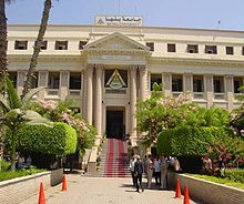
- Palace of the Chedives Abbas Hilmi. The palace of the Ottoman governor in Egypt and Sudan, ʿAbbās Ḥilmī I., was completed in 1850. He lived here in self-chosen seclusion. But he couldn't enjoy his palace for long. ʿAbbās Ḥilmī was strangled here on July 16, 1854 by two of his servants.
- Station building in Banhā.
- Stock exchange in Banhā.
More Attractions

- Old bridge (الكوبري القديم, al-Kūbrī al-qadīm).
- Corniche, the Niluferstraße, with the old villas and their gardens.
activities
Culture
- 1 Palace of Culture (قصر الـثقافة, Qaṣr ath-Thaqāfa) (Farid Nada St. joins the Corniche). (30 ° 28 ′ 16 ″ N.31 ° 10 ′ 39 ″ E)
Sports
The 2 Stadion from Banhā holds 10,000 spectators.
shop
kitchen
- Abou Ghazala Restaurant, Abou El Saud Bldg. Mobile: 20 (0)122 901 0308.
- El Canal Fish, Ferk El Amn St. (next to el-Sahaba mosque). Tel.: 20 (0)13 321 4701. Fish restaurant.
- El Ghamry Restaurant, 5 Farid Nada St.. Mobile: 20 (0)122 616 4460.
- El Ordony Restaurant, Sidi Abdel Rahman St.. Mobile: 20 (0)109 129 7198, (0)111 607 3618.
- 1 KFC (كنتاكي, Kintākī), Farid Nada St.. Tel.: 20 (0)13 321 0299, Fax: 20 (0)13 321 0288. Chicken fast food.(30 ° 28 ′ 14 ″ N.31 ° 10 ′ 59 ″ E)
- 2 L’Angoletto, Farid Nada St.. Tel.: 20 (0)13 321 3766. Fast food restaurant.(30 ° 28 ′ 15 ″ N.31 ° 11 ′ 5 ″ E)
- 3 Tahy, 3 Farid Nada St.. Tel.: 20 (0)13 321 4654, (0)13 324 7494. Fast food restaurant.(30 ° 28 ′ 13 ″ N.31 ° 10 ′ 53 ″ E)
accommodation
There is no hotel accommodation in the city. You have to go to hotels in Cairo or Ṭanṭā To fall back on.
Learn
The 1 Banha University was established in 1976 as a branch of the university Zaqāzīq founded. It has been independent since 2005. About 60,000 students study in 16 faculties, including the Faculty of Education, Engineer-, Natural sciences, economics, humanities and agricultural sciences as well as computer science, law, medicine and veterinary medicine. They are taught by around 2,000 teachers and professors. The main building is on the north side of Farid Nada St. The individual faculties are scattered across the city.

health
- 2 University hospital, Farid Nada St.. Tel.: 20 (0)13 322 8632, (0)13 322 8634, (0)13 322 8631, Fax: 20 (0)13 322 8635. (30 ° 28 ′ 13 ″ N.31 ° 10 '43 "E)
- 3 Training hospital (مستشفى بنها التعليمي, Mustashfā Banhā at-taʿlīmī) (30 ° 28 ′ 0 ″ N.31 ° 11 '9 "E)
Practical advice
police
The 4 Main police station is located about 900 meters north-northwest of the train station not far from the Corniche, behind a government building. You can reach them by dialing 122.
Passport office
The 5 Passport office is located in the security service building, Tel. (0) 13 324 2953. It is open from Sunday to Thursday between 9 am and 2 pm.
Banks
- Bank of Alexandria, 18 Saad Zaghloul St.. Tel.: 20 (0)13 325 3302, (0)13 326 1242, Fax: 20 (0)13 325 4746.
- 1 Banque de Caire, 1 Gami St.. Tel.: 20 (0)13 325 7811, (0)13 326 5834, Fax: 20 (0)13 326 1060. (30 ° 27 '55 "N.31 ° 10 ′ 46 ″ E)
- Banque Misr, Saad Zaghloul St.. Tel.: 20 (0)13 325 7214.
- 2 National Bank, Corniche el Nile St. Tel.: 20 (0)13 325 5706, (0)13 326 2282, Fax: 20 (0)13 325 7003. (30 ° 27 '54 "N.31 ° 10 ′ 38 ″ E)
Gas stations
There's one just north of the irrigation canal, east of the railroad tracks 7 Gas station.
Post office
- 6 New Banha Post Office(30 ° 28 ′ 22 ″ N.31 ° 10 ′ 44 ″ E)
trips
Excursions can be made to nearby towns Cairo, Ṭanṭā and ez-Zaqāzīq to be undertaken. About the rail connections to Alexandria and Dumyāṭ large parts of the Nile deltas to reach. More travel destinations are in the article on the governorate el-Qalyūbīya listed.
literature
- : Banhā. In:Gibb, Hamilton Alexander Rosskeen (Ed.): The Encyclopaedia of Islam: Second Edition; Vol. 1: A - B. Suffer: Brill, 1960, ISBN 978-90-04-08114-7 , P. 1015.
- : Banhā. In:Christian Coptic Egypt in Arab times; Vol. 1: A - C. Wiesbaden: Reichert, 1984, Supplements to the Tübingen Atlas of the Middle East: Series B, Geisteswissenschaften; 41.1, ISBN 978-3-88226-208-7 , Pp. 330-332.
Individual evidence
- ↑Population according to the 2006 Egyptian census, Central Agency for Public Mobilization and Statistics, accessed January 24, 2014.
- ↑: Athribis. In:Helck, Wolfgang; Otto, Eberhard (Ed.): Lexicon of Egyptology; Vol. 1: A - harvest. Wiesbaden: Harrassowitz, 1975, ISBN 978-3-447-01670-4 , Col. 519-524.
- ↑: Les pays. Le Caire: Inst. Français d’archéologie orientale, 1937, Publications de l’Institut Français d'Archéologie Orientale / Textes et traductions d’auteurs orientaux; 1, P. 193.
- ↑: Description de l’Afrique et de l’Espagne. Suffer: Brill, 1866, P. 152 (Arabic copy), p. 182 (translation).
- ↑: The translation of the reliques de saint Ménas à son église du Caire. In:Bulletin de la Société d’archéologie copte (BSAC), vol.16 (1962), Pp. 161-181.
- ↑: La geographie de l’Égypte à l’époque copte. Paris: Impr. National, 1893, P. 298.
- ↑: Egypt and the Sûdan: Handbook for Travelers. Leipzig: Baedeker, 1928 (8th edition), P. 32.
- ↑Citypopulation.de, accessed January 24, 2015.