| Ilha de Sao Vicente | |
| Capital | Mindelo |
|---|---|
| Residents | approx. 83,000 |
| other value for residents on Wikidata: 83467 | |
| surface | 227 km² |
| no tourist info on Wikidata: | |
| location | |
 | |
Sao Vicente (Cape Verde) (portug. Ilha de Sao Vicente) is one of the Cape Verde Islands, it has an area of 227 km² and belongs to the archipelago of the Islands over the wind (portug. Ilhas de Barlavento)
Regions
The island is relatively dry, only in the northeast there is some rain, caused by the northeast monsoon, whose clouds on the 750 m high massif Monte Verde get stuck. However, due to the expansion of the Sahel zone, the mountain is more brown than green. There are two other mountain ranges
- Madeiral with the 699 m high Toponal
- and Fateixa with the 535 m high Tope de Caixa
Its rugged cliffs testify to the island's volcanic origins. In the north of the island, a huge volcanic crater forms the natural harbor Porto Grande, he is guarded by the island Ilhéu dos Pássaros. At the entrance to the harbor you can see the 490 m high Monte Cara, also known as the Cabeça do Washington referred to as.
In the northeast of the island is the Baía das Gatassuitable for bathing. The subsequent Praia Grande is hardly suitable for this because of its strong surf. The beautiful light color of the sand is on top of that Harmattan traced back. It is a wind from the Sahara that over the centuries has called the sand brown fog has transported to Cape Verde.
The southwest of the island is known to windsurfers.
places
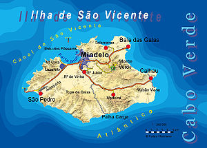
- Mindelo Island capital and cultural center
- São Pedro, small town with the island's airport
Other goals
- Baía das Gatas, a beach in the northeast of the island
background


On the island there are moderate temperatures between 22 ° C and 29 ° C all year round, there is rain in the Tempo the chuvas from August to October, otherwise there is mostly windy dry weather. Agricultural use is therefore only possible to a limited extent, there are significant cultivation areas mainly in the area of Monte Verde and especially where irrigation from wells is possible. The wind supplies the drive energy to operate the pumps at zero cost. Most of agriculture is based on the principle of self-sufficiency (Subsistence farming)


language
Portuguese and Creole.
getting there
By plane
The international Cesária Évora Airport![]()
![]()
![]() (IATA: VXE) is named after the singer Cesária Évora and is located in the southwest of the island near São Pedro. It is mainly from the Cape Verdean TACV and the Transavia, the daily number of flight movements is manageable small, the destinations are mostly on the neighboring islands. The flies from Lisbon TAP the airport.
(IATA: VXE) is named after the singer Cesária Évora and is located in the southwest of the island near São Pedro. It is mainly from the Cape Verdean TACV and the Transavia, the daily number of flight movements is manageable small, the destinations are mostly on the neighboring islands. The flies from Lisbon TAP the airport.
.JPG/320px-Aerogare_aeroporto_(S_Vicente,_Cabo_Verde).JPG)
By boat
- There are regular ferry services from the port of Mindelo to Porto Nuevo on the island Santo Antão.
- The port of Mindelo is also a frequent destination for cruise ships.
- From the port of Calhau there are excursions to the (uninhabited) neighboring island of Santa Luzia
mobility
