 | ||
| Taroko National Park | ||
| county | HualienTaichungNantou | |
|---|---|---|
| Residents | unknown | |
| no value for residents on Wikidata: | ||
| Tourist info web | http://www.taroko.gov.tw | |
| no tourist info on Wikidata: | ||
| location | ||
| ||
The Taroko National Park (太魯閣 國家 公園) is one of the 8 national parks in Taiwan and is particularly known for its eponymous gorge, which the Liwu River has cut deep into the marble rocks.
background
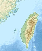
The Taroko National Park covers an area of 92,000 hectares and is located in the three provinces of Hualien, Taichung and Nantou. The area has an impressive geology including three mountain peaks over 3000 meters high. In one day it is possible to get from the flat coast of the Pacific to an altitude of 3000 meters. The park is home to the famous Taroko Gorge, the Chingshui Cliffs, the Baiyang Waterfalls and the Shakadang River.
The area was opened up by the Japanese when they carried out expeditions into the hinterland in search of raw materials. After 1945 the ambitious project of the Central Cross Island Highway was realized by the KMT directly in the Taroko Gorge, which was supposed to serve the purpose of quickly moving armed forces from one side to the other side of the island in times of war. Highway 8 is still the main thoroughfare in the park and leads to almost all of the sights. The park was not opened to the public until 1986.
The original inhabitants of the area are the Atayal. During the Japanese occupation, the people of Taroko fought resolutely against the Japanese expeditions, but were defeated by the Japanese. They were forcibly relocated and now live in the villages of Hsiu Lin, Choshi and Wan Rung. In the park, the names in particular are reminiscent of the old settlement areas, and you should plan several days to visit the park. If you just want to visit the gorge, you can get by on a full day.
climate
Subtropical rainforest and alpine climate, some with snow in winter.
Flora and fauna
From the subtropical evergreen forest to the alpine coniferous forest you will find all forms of vegetation in the park. Due to its special geology and the prevailing microclimate there are also seasonal tropical rainforests, e.g. near the Jinheng Bridge.
There are many species of birds, snakes and insects, which are adapted to the special climate of the park.
getting there
train
If you come by train from Taipei or Hualien, it is best to get off at Xincheng Station, which is closest to the park, in order to continue from here, e.g. with a rented scooter.[1]
bus
From the train station in Hualien buses e.g. from the Hualien Bus Company run into the park at different intervals. There is also a bus service between the east and west coasts that stops in the park. [2] The Taiwan Tour Bus also offers trips to Taroko [3]
taxi
You can have a taxi or a driver drive you directly into and through the park, but you should organize everything well in advance as there are only a few taxi drivers available for a full day trip. [4]
plane
At the airport of Hualien there is a bus stop to the national park.


mobility
You can get around very well by bus, but you should always keep an eye on the last bus for the return journey. The most comfortable thing is the car and a driver who will drive you everywhere; if you are brave, you can drive the narrow streets on a scooter. This is not recommended for the inexperienced, as coaches with tour groups are constantly thundering along the streets, always taking Highway 8.
If you have a lot of time, you can explore the park on foot using the old paths, but several days should be planned with overnight stays in the park.
Tourist Attractions
The most famous sight is the Taroko Gorge with its marble stones, but the park offers much more than just the gorge, which is why you should visit the visitor center at the beginning of your visit to find out about the possibilities and sights in the park museum. Up-to-date information is also important, as landslides can change the access points to the sights and the condition of the park on a daily basis.
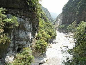
Taroko Gorge
Higway No. 8 winds along the Taroko Gorge. The gorge was created by the erosion of the Liwu River. Earthquakes and mountain collapses created a beautiful meander landscape, which is particularly known as the work of the gods due to its white marble. The leaching by the river as well as the meltwater and rainwater formed beautiful rock formations, which mostly have a name.
The main attractions of the gorge are:
The swallow grotto: A cliff in which natural nesting sites for the native swallows were created by leaching. In addition, there are holes in the walls through which the groundwater and rainwater from the mountain flow into the river.
The tunnel of nine turns is an impressive rock canyon with sometimes only ten meters between the walls.
The Cihmu Bridge is located at the point where the Laosi River meets the Liwu River. The marble and the green slate and the S-shaped folds give the estuary a special charm. The loose slate in particular repeatedly leads to falling rocks and slopes in the west of the bridge. The frog rock is located south of the Cihmu Bridge and is a large marble rock with a pavilion in honor of Chiang Ching-kuo's mother.
The Shrine of Eternal Spring was erected in honor of the workers who died during the construction of the highway and was repeatedly destroyed by earthquakes. The shrine is one of the most photographed sights in the gorge.
Buluowan

Buluowan is an old settlement of the indigenous people of Taroko. The plateau is located between Mt. Sanjiaohul in the north and Mt. Tai in the south. Buluowan means echo in the language of the locals, as the thunder is said to be particularly loud here during thunderstorms. There is an upper and a lower plateau, which are connected by a path. In addition to a wonderful view over the gorge, there is a museum about the locals and replicas of the traditional settlement buildings.
Shakadang Valley
The Shakadang Valley, through which the Shakadang River winds with its clear blue water, offers special rock formations made of mica and marble and one of the most beautiful hiking trails in Taroko Park. The word "Shakadang" comes from the language of the indigenous people who found molars of animals there.

Cingshui cliffs

The cliffs are part of the highest cliff in the world. A drive on the Suao Highway can sometimes be speechless when a truck comes towards you, since you have nothing but air between the road and the sea, which is 800 meters below you.
Baiyang waterfall
The region was discovered by an energy supplier who was looking for locations for a hydroelectric power plant on an expedition. However, the roads built fell victim to an earthquake, which is why it is no longer so easy to get into the area today. Rockfalls also often make the paths impassable. If you have time and rest, you should definitely take the hike to the waterfall.
activities
There are many hiking trails in Taroko National Park. It is important to know that for most of them you need a special permit, without which you cannot walk the paths. You can register in the various parking stations or online, if possible as soon as you know where you want to go. The releases are granted or rejected depending on the state of the route. Helmets are compulsory on many routes. The protective helmets can be borrowed at the park entrance or in the parking stations.
Most of the hiking trails are leftovers from the time the park was developed and the highway was built, or they are old supply routes but also old hunting trails used by the locals. Interesting trails are the Dekalun hiking trail (approx. 3 hours), the Shakadang trail (approx . 2 hours, walk), the Baiyang Waterfall Hiking Trail (1.5 hours) and the Lianhua Pond Hiking Trail (3 hours) as well as various smaller trails with a walking time of up to 30 minutes.
kitchen
There aren't many places to dine in Taroko National Park. The Taroko Visitor Center, Buluowan, Lushui, Guanyuan, Shrine of Eternal Spring and Tianxiang have small shops selling snacks. In Tianxiang you can find restaurants in the hotels.
accommodation
In Tianxiang, the only hotels are within the park. However, these are mostly filled with tourist groups, which is why you should look for rooms early, or better, look for accommodation in Xincheng or Hualien. There are still small accommodations in Buluowan, Tianxiang, Guanyuan and Songxue.
Those who like to camp will find various campsites, mostly right next to Highway No. 8.
security
The high cliffs are not to be underestimated. Earthquakes and typhoons in particular can cause landslides and rockfalls. That is why the gorge or parts of it are closed again and again in the event of danger.
Various poisonous snakes and insects live in the area, and their stings can cause allergic reactions.