| Tour of Lac de Joux (The Path - The Path) | |
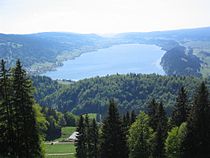 | |
| Joux lake | |
| Information | |
| Departure | The Path |
|---|---|
| Arrival | The Trail |
| Length | 16 km |
| Altitude | Between 1010 and m |
| Duration | 5 h 30 |
| Country | |
| Region | Vaud Jura |
| Location | |
 46 ° 38 ′ 22 ″ N 6 ° 17 ′ 9 ″ E | |
The Trek around Joux lake, is a circuit located at 1000 meters altitude in the Joux valley, in the Canton of Vaud.
Understand
This lake is fed by the Orb and the Lioness. Part of its water flows into its "little brother", Lake Brenet, but most of it flows underground and thus forms, several kilometers further, the caves of Vallorbe.
Steps
Main route
From the station East Trail, go in the direction of the wastewater treatment plant on Route Neuve. Turn left just before the bridge over the stream and follow the path. Passed the STEP, take the motorable path on the right on 300 meters. At the end, take the road to the right. Fork to the left after the bridge. Follow the path along the lake. Join the road in the village of Pont. Continue on the sidewalk then take a path. Continue near the lake, then enter a forest overlooking the lake. When you reach an intersection, turn left. Continue on more than 2,5 km. Arrived at the Place, continue in a straight street 500 m. At the bend, take the path down to the lake on the left. Continue along the lake. When you arrive near the Sentier WWTP, follow the same path as previously to arrive at the station.
Extension to Lake Brenet
In the village of Pont, at the junction of two roads, instead of continuing on the sidewalk, cross and take the road towards Mont d'Orzeires and turn left (towards the car park), cross the railway line and continue to right. It is possible to go around Brenet Lake without leaving this path. When you reach Les Charbonnières, continue straight on rue de Bonpont. Just before arriving at the road, take the lane on the left. At the end of the path, join the main street, take a lane opposite that goes up. Passed under the railway line, go up in the forest and continue straight ahead, then, as indicated above, reach the Place.
To go
- 1 The Path – Municipality of Le Chenit
- 2 The bridge – Municipality of the Abbey
- 3 The place
- 4 The Charbonnières – Municipality of the Place
Circulate
To see
Do
To buy
Eat
Have a drink / Go out
Security
Around
- 1 Mont d'Ozeires – Collar (1 061 m)
- 2 Caves of Vallorbe