Hike: Bad Frankenhausen - Barbarossahöhle - Kyffhäuser - Kelbra
Brief description
For high-performance hikers, the rather sporty hike of around 25km offers a real challenge. It leads from Bad Frankenhausen over the Barbarossa cave and the Kyffhäuser to Kelbra. This gives the opportunity to supplement the hike with appropriate visits. Due to time constraints, however, it is not possible to hike the route and visit the Barbarossa Cave and the Kyffhäuser Monument.
The hike begins on the hill from Bad Frankenhausen. The first highlight is the wonderful hillside path from the white kitchen to the Escheneck. Shortly afterwards two caves follow, the Prinzenhöhle and the Barbarossaöhle. You absolutely need a good flashlight for the Prinzenhöhle! If you like, you can join a one-hour tour (every full hour) in the Barbarossa Cave. Warm clothing is a prerequisite. There is a rock garden up on the Rathsfeld. Here the different (there are very many) rocks of the Kyffhäuser Mountains are exhibited and explained. This is followed by the area of the Kyffhäuserburg or the Kaiser Wilhelm monument. In addition to the freely accessible lower castle, the Kyffhäuser monument and a small museum can also be visited here. A look into the deepest castle well in the world is also possible. There are also attractions to visit in Kelbra. There is a local history museum in the premises of the tourist information office.
Part of the path runs along a new and well-designed educational trail. An on-call bus runs between Bad Frankenhausen and Kelbra. So the return journey needs to be well planned.
| begin | Bad Frankenhausen |
| aim | Kelbra |
| Intermediate goals | Barbarossa cave, Kyffhäuser monument |
| Duration (pure walking time with a brisk pace) | 6:00 h |
| distance | 25.3 km |
| Elevation gain (total) | 602m |
| Altitude descent (total) | -562m |
| Tourist Attractions | Barbarossahöhle, Kyffhäuser monument |
| Refreshments | Barbarossa cave, Rathsfeld, Kyffhäuser monument |
| suitable for children | yes, if the children want to run that far and like to crawl through caves |
| suitable for mountain bikers | yes, but only for the toughest ones |
| Local transport | two bus stops on the way |
| preferred season | all year round, except in winter |
| Abbreviations | available |
Make sure that the Kyffhäuser is a nature park!
Directions
| Directions | km | mark |
|---|---|---|
| The hike begins on the market square of Bad Frankenhausen. If you still need information, you can find out all sorts of useful things in the tourist information on the east side of the square. Above the tourist information office, turn left into Rosengasse. At the end of this there is a right to the Kleine Wipper. From there follow the "Kyffhäuserweg" marking. | 0 | no |
| After a few minutes you leave the city at the "Hoheneck". Where the fence ends on the right hand side, turn right! A small but very beautiful path leads through beautiful forests. After about 30 minutes you will be back on the "Kyffhäuserweg". At the intersection, go up the left ravine slightly on the right. At the next intersection, turn left again. | 1,0 |  |
| The path that follows is considered by many hikers to be the most beautiful in the Kyffhäuser Mountains. It is particularly interesting where, in addition to beautiful nature, there are also wonderful views. You have a look over to the sacrificial caves, with good visibility you can also see the Michelsberg near Göllingen. | 3,3 | |
| In Escheneck you stick to the markings in the direction of Barbarossahöhle. It's easy uphill again. In order to visit the Prinzenhöhle, you have to leave the marked main hiking trail for a moment. The Hohlweg (still Kyffhäuserweg) passes a small spruce forest on the left. Immediately at the end there is a 5-way intersection. Here you go half left on the forest road to the south. After only a few meters this becomes a small forest path, which you follow to the left. Now it goes through beech forests to a large gypsum hump and then right into a small valley. Shortly before the edge of the forest, in a birch forest (on the left is a large single pine), follow the left footpath parallel to the slope to the Prinzenhöhle. From the Prinzenhöhle the path continues down into the valley. There you have to follow the street to the right for about 100m. For once, stay here on the right-hand side of the road! The area is very confusing! A few meters away you come across marked hiking trails. | 4,71 | |
| From the Rottlebener Dreiangel, follow the Barbarossaweg in the direction of the Barbarossahöhle. | 6,87 |  |
| Above the Barbarossa Cave it goes north. Now follow the main hiking trail. First a typical karst landscape (large and small gypsum humps) emerges. The very different forest types make hiking a real experience of nature. | 8,52 |  |
| It goes past the "Great Resting Place". On an old and partly paved communication path, after a left curve, one arrives at the "Speierling". Shortly afterwards the path has a small low point. Here you turn left into the inconspicuous forest path. It goes to the Bingen. | 10,8 |  |
| Follow this path in a right curve around the small mountain. Soon it will be going slightly downhill. There you will find the well-preserved bingen. When you arrive in the valley, take the right forest path uphill again. After 700m you will reach the communication path again. | 12,0 | no |
| Once at the top, follow the left path. Walking again between Bingen you get to the Rathsfeld. Shortly over the B 85 and then immediately to the left, you get to the rock garden or the hiking car park. | 13,7 |  |
| From Rathsfeld continue on the Kyffhäuserweg in the direction of Kyffhäuser. The short section that follows follows a dead straight forest path to the duck pond. To do this, however, you have to leave Kyffhäuserweg at the next intersection. | 14,0 | |
| From here you follow the marking Bridle path. It goes slightly uphill and then back down again briefly to the Duck pond. | 14,5 |  |
| From the duck pond you have a top-class hiking trail under your shoes again. It leads down a real meandering path into the Lange Tal and then on an even nicer section to reach the Kyffhäuser. If you have enough, you can (if booked!) Start your journey home by bus at the small turning area. A visit to the historic Reichsburg and the Kaiser Wilhelm monument takes at least two hours. The more harmless and free small variant consists of a visit to the lower castle. | 15,9 | |
| It is always better to keep walking, because from here the paths are not only beautiful, but now there are also a few distant views. The path follows the northern slope on an educational forest path (students from Bad Frankenhausen have contributed to this) in the direction of Rothenburg. There is a lot to learn and experience here, especially for children. | 18,5 | |
| After a few bends, a small green shelter (wind hatch) appears in a left bend on the left. Here you follow the right path into the valley. After a few meters turn left again and then we reach the wild and romantic stone valley. Since the Steintal is a total reserve "R", you have to climb a little over the fallen trees. Here you can see the quarries, which are remarkable for those interested in geology, on both sides. The mountain now on the right (Wilder Mann) is a special highlight for nature lovers (crooked oaks!). The somewhat difficult path leads over a crossroads into the valley. | 21,2 | no |
| There you reach the Grenzweg (national border) to Kelbra. Turn left, a few more views of the Goldene Aue and across to the southern Harz, the wonderful avenue of linden trees, past a car repair shop, and you are already at the bus stop in Kelbra. | 22,9 |  |
Elevation profile

map

Source and license: CC-BY-SA
Hiking map: OSMC hiking & riding map
GPS data
The GPX file can be requested from the hiking boy. Just leave a message on the talk page.
Pictures of the hike
Here are the most important pictures of the hike.
 | 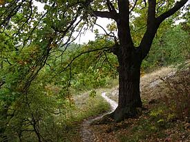 |  |
| Way from the Hoheneck to the white kitchen, km 1.0… 3.3 | Path to Escheneck, km 3.3… 4.71 | Hall-like beech forest and gypsum hump landscape, km 8.52… 10.8 |
 |  |  |
| Slate slabs at the pingen, km 12.0… 13.7 | Lower castle of the Reichsburg Kyffhausen, detour at kilometer 18.5 | Goldene Aue, Rothenburg at the top right, almost exactly 25.2 km |
Important waypoints
For some waypoints, a little support is offered here.
 |  |  |
| right up at the fence, km 1.1 | Shortly before the white kitchen, turn left onto the hillside path in the direction of Escheck, km 3.1 | after the ravine at the top left, immediately left again in the direction of the great Gipskuppe, km 5.8 |
 |  |  |
| just before the edge of the forest (there is a large pine on the left) take the small path on the left, km 6.2 | shortly after the Speierling, in the depression in the path, turn left onto the forest path, km 12 | at the small refuge right down, then immediately left again, km 21.2 |
Refreshments
There are plenty of opportunities to stop off at Barbarossa Cave there are two ways to strengthen yourself. In the warm season a snack (including grill) is open there. The rustic restaurant offers classic German cuisine all year round Rathsfeld there is an excursion restaurant "Zum Rathsfeld". The next options are on the Kyffhauser. There is also a snack bar next to the "Burghof". Of course you can also go to Kelbra stop by.
Web links
Who during the spread of the hike something on the topic Princes Cave want to read well, can do this here Karst hiking trail to do. Here too Kyopen there is a lot to be found about the small cave.
Other web links:
- The Barbarossa Cave operates its own website.
- On the subject of Pinging Wikipedia is a good choice.
- The Kyffhäuser Monument is also present on the Internet.
Further information on the region can be found on the website of Kyffhäuser tourist information remove.
Means of transport
The on-call bus (Tel. 01805-331010) must be ordered no later than two hours (as of 2010 season) before the departure specified in the timetable! NASA