 | ||
| Office Wilstermarsch | ||
| federal state | Schleswig-Holstein | |
|---|---|---|
| Residents | 4350 (City of Wilster) 6800 (Wilstermarsch Office) | |
| no value for residents on Wikidata: | ||
| height | unknown | |
| no value for height on Wikidata: | ||
| no tourist info on Wikidata: | ||
| location | ||
| ||
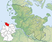
The Wilstermarsch is a marshland on the Lower Elbe and an office (administrative community) from 14 communities around the city Wilster. It is in the southwest Schleswig-Holstein, between Itzehoe and Brunsbuettel.
At 3.54 meters below sea level, the deepest land point in Germany is located in the Wilstermarsch.
background
The municipalities of Aebtissinwisch, Beidenfleth, Brokdorf (nationally known for the nuclear power plant), Büttel, Dammfleth, Ecklak, Kudensee, Landrecht, Landscheide, Neuendorf-Sachsenbande, Nortorf, Sankt Margarethen, Stördorf and Wewelsfleth belong to the Wilstermarsch district. The city of Wilster itself is not officially part of the office, but forms an administrative community with it.
Wilster is well-known nationwide among motorists, as it has been used for decades as an example for the place-name sign in the appendix to the StVO.
getting there
The Nord-Ostsee-Bahn between Itzehoe (6 minutes travel time) and Heide (35 minutes) stops every hour at Wilster station. Coming from Hamburg-Altona, you have to change trains in Itzehoe and it takes a good hour in total.
From Hamburg or Heide you can take the A 23 motorway to the junction Itzehoe center to take. There is a connection to the motorway-like B 5, which leads directly into the Wilstermarsch. The almost 70 km from Hamburg takes a little less than an hour in favorable traffic conditions, and of course longer in rush hour traffic. From the other side of the Elbe (Cuxhaven and Stade area) you can take the Wischhafen – Glückstadt ferry.
mobility
The public transport in the Wilstermarsch office takes care of Zweckverband ÖPNV Steinburg with the lines 6601 Abbessinwisch – Ecklak – Wilster, 6602 Wilster – Kudensee – St.Margarethen, 6603 St. Margarethen – Averfleth – Wilster, 6604 Wilster – Brokdorf – St. Margarethen, 6605 Kudensee – St. Margarethen – Wilster, 6606 Itzehoe –Wilster – Brunsbüttel, 6607 St. Margarethen – Neufeld – Wilster, 6608 Wewelsfleth – Klein Kampen – Wilster, 6609 Wilster – Beidenfleth – Wewelsfleth – Brokdorf and 6610 Wewelsfleth – Kleinwisch – Wilster. With the exception of the 6606, the buses only run a few times a day, and usually not at all on the weekend. Timetables.
Tourist Attractions


1 Germany's deepest land (3.54 m below sea level). It's not a spectacular tourist attraction, but worth a visit if you're in the area. It is marked by a height mast on which, in addition to sea level, various other heights are marked (height of the Elbe dykes and levels of various storm surges). On one Artesian well the water emerges independently due to the low location. An information board explains the principle. The place is completed by a rest area with a refuge and an information board about the Wilstermarsch. You can find the small parking lot on the country road Castle–Wilster in Neuendorf-Sachsenbande, just under 7 km northwest of Wilster, 6.5 km southeast of Burg.