
| Free State | |
 | |
| location | |
 | |
| Flag | |
 | |
| Main information | |
| Capital city | Bloemfontein |
| Surface | 129 480 |
| Population | 2 700 000 |
| Tongue | SiSwati (30.8%), IsiZulu (26.4%), IsiNdebele (12.1%), Sepedi (10.8%) |
Free State - province of w South Africa. To the south-east it borders with Lesotho. Until June 9, 1995, the province was called the Free State of Orange.
Characteristic
Geography
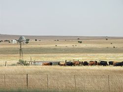
The Free State is situated in the vast plains in the heart of South Africa. The fertile lands and the mild climate allowed agriculture to flourish. With 30,000 farms producing 70% of the country's grain, the province is known as South Africa's granary. The province is located in the highlands, with an average altitude of over 1000 meters above sea level. The foothills of the Drakensberg and Maloti Mountains in the east raise the area to over 2,000 m above sea level. The Free State is at the center of the Carrara Rock Range, which includes shale, mudstone, sandstone and basalt of the Drakensberg Mountains. In the north and west of the province there are large mineral deposits, of which gold and diamonds are the most important.
Climate
Dry tropical continental climate. On the eastern side, the wetter annual total of waste is 1000 mm and about 400 mm in the west. The average temperature in January is 22-25 ° C, in July around 10 ° C.
History
Policy
Economy
The basis of the economy is agriculture. Mainly crops are crops such as maize, wheat and oats, fruit trees such as plums and apple trees, vegetables and tobacco. Sheep, goats, horses and cattle are bred. An important branch of industry is the mining industry. Gold and uranium ore are mined in the area of Welkom and Klerksdorp, diamonds, hard coal in the vicinity of the city of Sasolburg, and bentonite.