| Achaia | |
 | |
| Information | |
| Country | |
|---|---|
| Area | 3 272 km² |
| Population | 309 694 hab. (2011) |
| Density | 94,65 inhab./km² |
| Location | |
 38 ° 7 ′ 49 ″ N 21 ° 52 ′ 34 ″ E | |
| Official site | |
THE'Achaia is a region of Peloponnese.
Understand
Regions

Cities
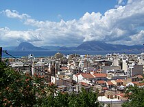
- 1 Patras – Patras is the third largest city in Greece after Athens and Thessaloniki and is the second Greek port behind that of Piraeus
- 2 Kalvryta – Small mountain town connected to the port of Diakofto by the only cogwheel train in Greece
To go
By plane
- 1 Araxos Airport (IATA : GPA, ICAO: LGRX, Αεροδρόμιο Αράξου) in Araxos (in the Dimos Dytikis Achaias, at 45 km west of Patras)
Circulate
Do
To buy
Eat
Have a drink / Go out
Security
Around
- Kalogria beach: Sand dunes next to swamps and surrounded by large pine forests that form the Strofilia forest.