 | ||
| Andros | ||
| province | ||
|---|---|---|
| Andros has no parent region. | ||
| Residents | unknown | |
| no value for residents on Wikidata: | ||
| height | 7 m | |
| no tourist info on Wikidata: | ||
| location | ||
| ||
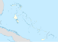
Andros lies in the central west of the Bahamas.

Regions
Usually one speaks only of the island of Andros and describes it as the largest island in the Bahamas group. In reality, it is made up of some large parts of the island with lots of water and smaller islands in between. The largest part of the island in the north is North Andros with most of the infrastructure.
The island part is located in the very south South Andros. Almost in the middle of the land masses, so-called bights, ie "indentations" in west-east direction, are navigable waterways across the entire island. The big ones are surrounded by these waterways Mangrove Cay and the smaller one Big Wood Cay.
All four parts of the island are more or less inhabited. Together they form the backbone of the island over a length of about 160 km, so to speak, with an almost continuous transport connection. This is followed in the east with the second largest coral reef in the world with a length of 233 km and then a body of water called "Tongue of the Ocean", a trench almost 3,000 meters deep in the sea.
Other goals
background
Andros is only 75 km west of Nassau. This largest of the Bahama Islands, 166 km long and 64 km wide, is very flat, divided by inlets and inland lakes. The total area is 5,957 km², the population is given as 7,686. The islands are mostly overgrown by mangrove swamps, thickets and forests, pine and mahogany. There are large areas of shallow water all along the west coast. In the interior of the country there are 178 so-called blue holes, water-filled collapses in the limestone, and another 50 are in the coastal zone. There are only a few traffic routes, mainly along the slightly hilly east coast. Some of the bays have to be crossed by ferries. Inland there are only a few slopes for the removal of felled trees. In the north around San Andros you can find some agriculture. A large research institute for cattle breeding had to be abandoned. Today only vegetables are grown and there are some citrus plantations.
The three “bights” that cross the island in an east-west direction are passable. Guides are available on Mangrove Cay. With the help of the tides, the passage is possible in 2 hours. The South Bight with a greatest depth of 1.5 to 2 meters at low tide is the easiest to drive through.
Off the east coast is the second largest coral reef in the world with a length of 233 km. Behind it, the sea floor in the "Tounge of the Ocean" drops to 1,500 to 2,000 meters. The US Navy has chosen this deep trench as a test area for submarine weapons. In 1964, the “Underwater Test and Evaluation Center” AUTEC was established at Fresh Creek, an absolutely restricted area!
The second largest white-headed pigeon breeding colony in the world is in the vicinity of Kemp's Bay. The birds can be hunted from September to March.
Due to the abundance of fish, Andros is very popular with deep-sea anglers and is proud of the attribute "bone-fishing capital of the world”. But blue marlins, barracudas, squid and large perch are also drawn ashore.
history
Christopher Columbus called the island "La Isla del Espirito Santo“- Island of the Holy Spirit. Legend has it that in the Red Bay area lived goblins with red eyes, three fingers and three toes - called "chickharnies" - and dragons - "Luscas" - are said to exist in the forests. In the 17th century, North Andros was a refuge for the Seminole Indians who fled south Florida from the Spanish. They settled in what is now Red Bay Village, where their descendants still live with traditional rites and customs.
The island is probably named after Sir Edmund Andros (1637-1714), 1672 commander of the royal troops in Barbados. A map with the island name San Andros appeared as early as 1782. Between 1783 and 1787, residents of St. Andro from the Mosquito Coast settled on the island.
In 1788 the colony had 7 planters, 22 family members and 132 slaves.
After the abolition of slavery, released ex-slaves from Exuma and Long Island came to South Andros in search of farmland. In the 1840s, escaped Indians and “Negro slaves” came from Florida across the sea to North Andros at the same time.
getting there
There are airports on all three larger parts of the island. They are connected to each other by ferry connections. From the capital Nassau, on the island New Providence, there are several boat connections there.
mobility
There are some minibus connections without a fixed timetable. Cars and bicycles can be rented.
activities
Fishing and diving are the main activities that can be enjoyed.