This route leads on the Pamir Highway (M41) from Chorugh in the Gorno-Badkhastan Autonomous Oblast (GBAO), Tajikistan, to Osh, the second largest city Kyrgyzstan. Depending on the variant, it leads 800 to 1000 kilometers through the lonely mountains of the Pamir, along the Afghan, Chinese and over the Tajik-Kyrgyz border. This route can be traveled in both directions. However, from south to north (Tajikistan to Kyrgyzstan) the rise in altitude is less abrupt. This route description is also primarily based on the Chorugh-Osh direction.
The attraction of the route is the landscape and insights into the reality of life of the local people. You spend a lot of time on the go. The towns or villages on the way do not have any sights worth mentioning on their own.
Arrival and departure

From the Tajik capital Dushanbe it takes around 16 hours to drive to Chorugh; So one or two days with a stopover in Qal'ai Khumb. The route costs around € 30 per day in a shared taxi (i.e. also that you pay almost twice as much for the more comfortable two-day variant).
Alternatively, you can cover this route in around a week by bike or fly (only in good weather).
Osh on the Kyrgyz side offers an international airport and daily marshrutka connections to Bishkek and other cities in Kyrgyzstan.
money
US dollars in small bills are popular as a means of payment for accommodations in Tajikistan and Kyrgyzstan, because their value is much more stable compared to local currencies. Ideally, you should bring new $ 1, $ 5, and $ 10 bills with you from home that are undamaged. For other expenses, it is advisable to withdraw enough cash in Dushanbe or Osh to be able to pay the driver and car, accommodation and food (2017 approx. $ 15 / night and person with dinner and breakfast).
formalities
For the GBAO region, a so-called Tajik visa is required in addition to the regular Tajik visa. GBAO permit required. Both must be requested in advance and cost € 70 together. In Kyrgyzstan, EU citizens receive a free Visa on Arrival. (As of 2017)
Choice of means of transport
The route is popular with cyclists and tourists in rental cars alike.
bicycle
The Pamir Highway is popular with cyclists because there is little traffic and the scenery is literally breathtaking. Due to heights of up to 4500 m above sea level, the physical demands should not be underestimated. The distances between places with overnight accommodation are sometimes so great that it is better to bring a tent with you. The entire route takes about two to three weeks by bike.
Car (chartered)
As a quick and physically less demanding alternative, chartered cars (with local drivers included) are a good choice. The costs are around $ 800 (start in Tajikistan) and $ 1000 (start in Kyrgyzstan). The price depends almost entirely on the distance covered, each detour costs extra, and additional time is practically free. When renting a car with a driver, it should be clarified whether the driver or the car can cross the border (depending on nationality and direction, this can be difficult), and whether bribes for corrupt police officers and border officials are already included (amounts to a middle two-digit euro amount for the entire route). Because of the altitude and consequently thin air, no diesel vehicles are used in the region. For the variant via Ishkashim / Langar, an off-road vehicle is recommended.
Public transport
Public transport only exists between Khorog and Murghab. The entire rest of the route and especially the delightful one Guard corridor are not developed, so that public transport is not an option for this route.
variants
The route is roughly as follows:Chorugh – Alichur – Murghab – Karakol – Osh
However, there are some attractive "detours":
Across the Wachan Corridor
Instead of driving directly on the M41 from Chorugh to Alichur in about eight hours by car, there is a multi-day detour via Ishkashim, Yamachun and Langar in the guard corridor. (Approx. 3 days by car, 1 week by bike.)
The Guard corridor is a valley in the extreme southeast of Tajikistan, which separates the Tajik Pamirs from the Afghan Hindu Kush. Strictly speaking, what is referred to here as the Wachan Corridor is more like the upper reaches of the Panj. The valley along the Wachan River lies entirely on the Afghan side. The latter is often referred to as "Afghan Wakhan" to distinguish it.
What speaks against this variant, especially from the perspective of cyclists, is the significantly poorer road quality compared to the asphalt section via the M41.
The Foreign Office sometimes advises against traveling to the border district Ishkashim, through which a large part of this detour runs. The reason for this is the close proximity to Afghanistan. In spring 2017, Russian fighter jets attacked advancing Taliban fighters on the Afghan Panj side. The Aga Khan Foundation, otherwise known for its humanitarian projects, finances mercenaries on the Afghan side of the Wachan Corridor. Locals can often better assess the current security situation than the Federal Foreign Office.
Excursion to Bulunkul

A path branches off where the asphalt M41 and the gravel road from / into the Wachan corridor via Langar meet (a few kilometers before Alichur from the direction of Chorugh) Bulunkul from, the coldest place in Central Asia in the immediate vicinity of a lonely mountain lake and nature reserve of the same name. You can plan a few hours for this by car, or overnight in Bulunkul by bike.
Peak Lenin
On the Kyrgyz side, you can leave the M41 a few kilometers after / before the border at Sarytasch and take a detour to the base camp of around 50 km oneway Peak Lenin Companies. The view of the Alay chain is fantastic in good weather and the road is super developed, especially compared to Tajikistan.
course
Chorugh
In the guesthouses and homestays in Osh or Chorugh there are the best chances of meeting other travelers who, for example, also want to charter a car. In addition, the two end stations of the itinerary have ATMs and internet connections, which are not available on the rest of the M41. In Osh the cash supply is stable, in Chorugh there can be bottlenecks, so you can get more money out of it Dushanbe brings along.
from Chorugh to Alichur (without detour via the Wachan corridor)
From Chorugh to Alichur (via the Wachan Corridor)
Garm Chasma and Ischkaschim


After about two hours by car from Chorugh in the direction of Ishkashim, you get to the hot, sulphurous springs of Garm Chasmawhen you after the checkpoint at Andarob drives almost ten kilometers inland along a tributary of the Panj. In Garm Chasma, men and women take turns bathing in pools of different sizes, separated by corrugated iron screens, under a large sulfur-covered rock. Locals with skin diseases in particular visit the sources. A symbolic entrance fee is required from foreign tourists. In the immediate vicinity of the source, something is emerging that can be described as a health resort infrastructure: a hotel and a few shops.
Back on the road, it always runs upstream along the border river Panj. Except for occasional patrols to prevent drug smuggling or contact from the Afghan side, you only meet a few cars or other travelers. Before Ischkaschim you pass some mineral springs on the left. Shortly before Ishkashim (Ишкошим) the valley of the river widens noticeably - a clear change after seeing only comparatively narrow valleys from the direction of Chorugh for days. The town Ishkashim apart from its gas station and the border crossing to Afghanistan, it is meaningless and has no attraction. There are some sleeping possibilities and (depending on the current security situation) one weekly Cross border market, similar to the one at Chorugh Airport. During the week, public transport occasionally runs to Ishkashim.
Vichkut / Bibi Fotima / Yamchun

After Ischkaschim the road becomes even emptier and the valley wider and wider. You pass the castle ruins of Qah-Quaha (Қальаи Қаҳқаҳа) on top of which there is a military post. The next bigger place is Vichkutlocated below the Bibi Fotima hot springs hugs the mountainside. Unlike those of Carm Chasma, the Bibi Fotima hot springs are surrounded by a complex of buildings that looks like a miniature indoor swimming pool. Here, too, men and women bathe separately. Along the serpentines from the road to the hot springs there are some homestays and a hotel directly at the springs. The ruins of the castle are also within walking distance of the springs Yamcha. The view from there of the meandering river and some glaciers in the Hindu Kush is more worth seeing than the ruins themselves.
Vrang, Zang and Langar

The village lies further up the Panj river Vrang. The main attraction of the place is a Buddhist stupa slightly above the place, which is small compared to stupas from Buddhist regions of the world, but in the context of today's exclusively Muslim population and in front of the mountain panorama it is quite spectacular. The path to the stupa begins at the northern exit of the village and takes about 20 minutes from the main road.

At Pincer or the neighboring Langar the Wachan flows into the Panj from the Afghan side. Zang is a cluster of houses around a gas station. In Langar there are some homestays, all of which are advertised on the main street. Petroglyphs (stone paintings) can be found above the village. In order to find at least the beginning of the way there, it is best to ask local children who are happy to help for a small pocket money. From the petroglyphs and the much higher mountain peak there is a fantastic panorama of the Hindu Kush.

To the north of Langar the road goes steadily uphill and moves away from the border river, which without the water masses of the Wachan is only a little river a few meters wide or at a wading depth. The area is deserted on both sides of the border, and occasionally you come across grazing cattle frolicking on the unreal green grass along the river bank. After all, you meet at Khargush shortly before the pass of the same name to a military post and checkpoint, which offers a guarded "campsite" for bicycle tourists. After the Khargush pass, the gravel road runs past salt deserts and shallow ponds created by evaporation until it finally joins the asphalt M41 shortly before Alichur. From here you can turn left and then right again to Bulunkul or directly right to Alichur.
Bulunkul

Bulunkul is a desolate mountain village, where temperatures down to -60 ° C are measured in winter. The weather station that measured this value is located directly at the entrance to the village, and the nature reserve of the same name begins shortly after the village, with a large lake in the middle. An entrance fee is required and you have to leave your own passport as security. You can walk from the lake to the Sarez lake reach.
Alichur

Alichur is a place where, including the surrounding villages, almost 2000 people live. It is strategically located between Murghab, Chorugh and the Kargush Pass. "ры́ба и пи́во" (beer and fish) is the local specialty, which is offered in local restaurants, often with an attached yurt. There is a gas station and a couple of homestays. At the end of the village in the direction of Murghab there is a fenced-in pond in which numerous, sacred, fish live.
Murghab
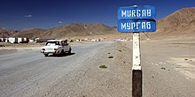
Murghab is about 2-3 hours by car from Alichur. The way there meanders through the lunar landscape of the Pamir and is particularly spectacular in the morning or evening light because of the intense colors of the mountains. The place has a hotel ("Pamir Hotel") and several homestays. In the high season it can be difficult to find a room late at night. Murghab is the administrative center and is therefore equipped with a police station, a mosque, several gas stations, an airfield and the obligatory snow-white statue of Lenin. Drivers often do their first border formalities here. Anyone who has come to Murghab from Chorugh by public transport still has the opportunity to find a driver in the direction of Kyrgyzstan. The road branches off in Murghab Kashgar from.
Karakul

Past several military ruins, which go back to Tsar Nikolaus, and over the highest point of the route with 4655m, the Ak Baital Pass, you approach in the direction Karakul more and more of the Chinese border. Yaks graze in the steppe off the road, occasionally there are herder camps offering fresh cheese and tea or an overnight stay. The last kilometers before the village of Karakul on the lake of the same name (not to be confused with Karakol in Kyrgyzstan) run along a border fence that marks the beginning of the buffer zone with China. World empires met here during the times of the Soviet Union. You shouldn't get too close to the fence as there is a risk of mines. Karakul is a poor village that blossoms for a few days when the annual "Karakul Swim Run" takes place in midsummer. The residents feel more connected to Kyrgyzstan than Tajikistan, as the Kyrgyz city of Osh is closer than Chorugh or Dushanbe. The water of the mountain lake is slightly salty and crystal clear. For swimming there is a pebble beach within walking distance south of the village. The only annoyance: when there is no wind, hosts of mosquitoes cavort in the meadows around the lake. Fortunately, there are no mosquito-borne diseases at this altitude.
Over the Kyzylart Pass to Kyrgyzstan
About fifteen kilometers outside of town, inconspicuously to the left of the street, is an old solar calendar made of rows of stones arranged above the ground. The M41 moves further and further away from the lake until it leaves Tajikistan just before the Kyzylart Pass. The border guards and drug investigators stationed there speak well of Europeans, because the EU financed the accommodation they built in 2017 according to Western standards. There is a border guard who will exchange US dollars and Tajik somoni for Kyrgyz somoni, depending on availability. The rate is not much worse, at least for Somoni, than in exchange offices in Osh and you have the money directly available instead of having to rely on an ATM.
The Kyzylart Pass itself is in the no man's land between Tajikistan and Kyrgyzstan. The road maintenance depot, where cyclists can also spend the night, is located roughly in the middle of the twenty-kilometer stretch of road. As soon as you reach the northern slope of the pass, the landscape becomes noticeably greener. Entry into Kyrgyzstan is uncomplicated for Europeans (Visa on arrival). However, Tajik cars are carefully examined by the Kyrgyz border officials or they can be generously lubricated. After the gravel and gravel road in no man's land, the cleanly paved Kyrgyz road immediately looks like a German autobahn. The road runs flat and straight for kilometers through lush meadows in summer towards the village of Sary-Tash. The panorama of the Alai chain in the back is impressive.
Peak Lenin

If you do not drive straight ahead in the direction of Osh in Sary-Tash, but instead turn left towards the west from Tajikistan, you will reach the base camp of Peak Lenin at an altitude of approx. 3500 meters after about two hours by car. The location is spectacular: towards the south of the Pamir and when the sky is clear (most likely in the morning) the view of the 7000 meter peak Lenin. In the immediate vicinity of the base camp green meadows with picturesque deep blue ponds, small yurt camps, paws and wild rivers. The area is well suited for hikes and, of course, the ascent to the summit, which is reserved for experienced mountaineers. Allegedly you need a special permit for this border region (August 2017: Not a single check).
Osh

From Sary-Tash it is only about three hours by car to Osh. The road is well developed. The climate is getting warmer, which is due to the low location of the Fergana Valley. Osh is a large city with around 250,000 inhabitants. There is internet, ATMs, local public transport, air and bus connections to China, Uzbekistan and all of Kyrgyzstan.
Onward journey
From Osh you can get there in around two hours by bus Arslanbob with change in Jalalabad and Bazar Korgon. There is also a daily marshrutka from Osh via Bazar-Korgon Sary-Chelek