| Cape Town Cape Town | ||
 | ||
Coat of arms  | ||
| Salutation | Mother city, Taverna of the seas | |
|---|---|---|
| State | South Africa | |
| Region | Western Cape Province | |
| Altitude | 0-1,590 m a.s.l. | |
| Surface | 2,455 km² | |
| Inhabitants | 3.740.026 (2011 census) | |
| Name inhabitants | Capetonians | |
| Prefix tel | 27 21 | |
| POSTAL CODE | 8000 | |
| Time zone | UTC 2 | |
Position
| ||
| Tourism site | ||
| Institutional website | ||
Cape Town (in Afrikaans Kaapstad, in xhosa iKapa, in EnglishCape Town) is the capital of the Western Cape Province, one of the provinces of South Africa.
To know
Squeezed between ocean and mountains, Cape Town is the most touristic city and the oldest in the South Africa as well as being considered one of the most beautiful on Earth. Cosmopolitan capital, it has a unique architectural heritage in which Dutch farms are flanked by neo-Gothic churches, Muslim minarets and Georgian and Victorian buildings, testifying to its varied colonial past. "The mother city", in the southernmost part of the African continent, is home to one of South Africa's most beloved coastlines, with more than 400 shops for all tastes and budgets. From here it is also possible to visit Robben Island, the ancient prison where Nelson Mandela spent 27 years in prison.
Geographical notes

Cape Town is located at 33.55 ° South of latitude, roughly the same as Sydney is Buenos Aires and equivalent to that of Casablanca is Los Angeles in the Northern Hemisphere.
The original nucleus of the city developed around the Gulf of the Table (Table Bay) which offered guarantees for a safe harbor. From the early years of Dutch rule the city expanded south of the port, in the small basin bounded to the west by Signal Hill and to the south and east by the almost vertical buttresses of the mountain of the Table (Table Mountain) whose highest peaks, "Devil's Peak" (Devil's Peak) and "Lion's Head" (Lion's Head) delimit a small internal plateau (hence the name) located at an average altitude of 800 m a.s.l. Often the two peaks appear shrouded in nuanced clouds known in local jargon as "the tablecloth".
Table Mountain constitutes the extreme northern offshoot of the mountain ridge that extends for about fifty kilometers south into the waters of the Atlantic Ocean, forming the slender peninsula that ends in the Cape of Good Hope on one side and Cape Point on the other.
Much of the outskirts of Cape Town occupies the plain Cape Flats, located east of Table Mountain and facing south on False Bay, the wide crescent-shaped gulf, so called because in past times the sailors landed there, mistaking it for Table Bay.
When to go

Cape Town enjoys a temperate Mediterranean climate, comparable to that of Liguria or of the French Riviera or even to that of California southern.
Winter (from early June to late August) is characterized by average temperatures ranging between 18.0 ° C and 8.5 ° C but for a short period, usually in July, the city is subject to cold fronts caused by a strong wind blowing from the north-west that brings with it abundant rains.
Summer (early December to March) is hot and dry with average temperatures of 26.0 ° C and lows of 16.0 ° C. In the summer period the heat in Cape Town can become truly unbearable when between mid-February and early March the "mountain wind" (Berg Wind), coming from the semi-desert region of Karoo.
Late spring and early summer are generally characterized by another strong wind from the southeast, known locally Cape Doctor (The Cape Town Doctor), so called because it wipes out air pollution.
The water temperatures vary considerably: in fact, they range from 10 ° C on the Atlantic side to over 22 ° C in False Bay. Those accustomed to the warmth of the Mediterranean waters will find it almost impossible to bathe, even in the height of summer, in the waters of Camps Bay, Clifton and other beaches on the Atlantic side, including those in the sheltered gulf of Hout Bay.
Background

The Dutch were the first among the Europeans to settle in the area where Cape Town stands today.
On April 6, 1652, a small group of settlers landed at Table Bay under the orders of Jan van Riebeeck who had been commissioned by the Dutch East India Company to found an outpost where Dutch ships could stop and refuel on the long route from motherland to the East Indies.
At that time the Cape Peninsula was inhabited by the Khoe, also called "Hottentots" and dedicated to breeding. The relations between the settlers and Khoe did not take long to deteriorate and the base was no longer able to guarantee supplies to the ships. Repeated clashes followed one another until 1677, after which the tribes were dispersed as well as their flocks.
The new colony was short of manpower and there was a need to complete the fort and port infrastructure. The timber was not abundant and the few woods in the surrounding area soon disappeared. Thus it was that Van Riebeeck asked the company to provide him with the slaves needed to complete the works. The first slaves arrived fromAngola on galleons stolen from Portuguese. Others followed from the most disparate places, from the neighbor Madagascar as from far away Sulawesi in Indonesia.
Thanks to forced labor, the new colony developed rapidly and the whites (Burghers) became wealthy landowners. The male population far exceeded the female one so widows and young orphans were brought in from Holland. The company maintained close control of the colony. Its aims were only commercial and it was not interested in social services. In Cape Town, schools were rare as were missionaries and churches. However, the company did not have control of the rural areas where they were built continuously to the detriment of the Khoe, new farms, dedicated to viticulture or livestock. Throughout the eighteenth century the Boers (farmers) built splendid mansions in the center of their plantations built following the example of those of Amsterdam. Literacy levels declined rapidly especially among those settlers who had gone farther from Cape Town. The Calvinist faith also deviated from the original teachings and the concept of a right to conquer the new lands of divine endowment was developed. Under this concept, the colonists fired on sight at the Khoe men and kept their women with them.
In 1780 the war broke out between Great Britain is France. L'Holland sided with thislast and French troops settled in Cape Town to prevent an invasion by the common enemy. Fifteen years later the alliances were reversed as a result of the invasion of Holland by the French revolutionary troops. The British fleet under Admiral Keith Elphinstone landed in Cape Town in June 1795 under the pretext of preventing Napoleon from taking possession of the colony. Their new possession was recognized by the Congress of Vienna. The slaves were emancipated in 1834.
How to orient yourself
Finding your way around Cape Town is easy. The city center has a checkerboard layout and lies in a narrow hollow between Signal Hill, Devil's Peak to the west and Table Mountain to the south. Thanks to their unmistakable silhouette these hills provide a precise indication of where you are, considering also that Cape Town lacks very tall buildings.
Central districts
- City Bowl - The city center (City Center), better known as "City Bowl", occupies a relatively small area. Its heart is represented by Greenmarket Square. The square once served as a slave market. Today a flea market is held there which is overflowing with souvenirs and handicrafts. Nearby is the neoclassical Parliament building erected in 1894.
- Thanks to the numerous bars and restaurants that overlook it, Long Street it is the most famous of the streets in the center. The artery moves from the port to end in the Company's Gardens area in which some of the most important city museums are located.
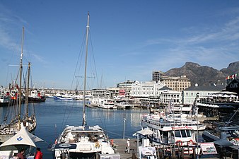
- Victoria & Alfred Waterfront[1] - The Waterfront is today the area of the center most preferred by tourists and the one where it is desirable to find accommodation, despite the often prohibitive prices. Choose a hotel on the Long Street or in other areas of the City Bowl it could in fact result in a disappointment.
- The old ones docks host an incredible number of clubs and shops. There is the "Two Oceans Aquarium" and from here you can take the ferry to Robben Island with the penitentiary where Nelson Mandela was detained at the time of apartheid.
- De Waterkant - A makeshift neighborhood where the hotel can be found, given the decidedly lower prices, especially in its upper part, perched on the slopes of Signal Hill.
- Although extending close to the Victoria & Alfred Waterfront, De Waterkant is not administratively part of the center but of the Green Point district where a new stadium was built to properly host the 2010 World Cup.
- De Waterkant is the area of choice for young professionals and is reputed to be Cape Town's gay district.
- Bo-Kaap - On the slopes of Signal Hill, Bo-Kaap is a historic district where people originally settled Malaysians deported to Cape Town by the Dutch colonies of the East Indies to make up for the lack of local labor. Very picturesque due to its stone-paved streets, Bo-Kaap now houses the mosque and the oldest museum in Cape Town. After the end of Apartheid it became an area for wealthy families.
- Sea Point (Afrikaans: Seepunt) - Extension of the center, Sea Point is the narrow neighborhood between the ocean and the northwestern side of Signal Hill. Densely populated, Sea Point has the advantage of offering the closest beaches to the center. Further south are those of Camp Bay and Clifton, both neighborhoods with an exclusive character and whose few hotels can have three times the price of those in the center.
- Gardens, Oranjezicht, is Vredehoek - To the south of the center and at the foot of Table Mountain, these three residential districts, which are considered wealthy on the whole, stretch out. Gardens in particular is renowned for its funny guesthouses with a panoramic view of the center and the port and the large number of clubs aimed at wealthy young people. There is also the cable car station for Table Mountain.
Outlying neighborhoods
- Observatory - The university district, located just below the Devil's Peak, a few kilometers east of the train station. It has several hostels listed below but all in all it is an area that is suitable only for young people imbued with alternative culture.
- The Flats - In the eastern part of False Bay, more inland, along the route of the N2 that leads to the airport, are the Flats, a flat area, as the name indicates.
- At the beginning of the 19th century, the black population of Cape Town was confined to this area with the aim of containing an epidemic of bubonic plague that threatened to claim many victims. The Flats still constitute a sort of black ghetto despite the end of Apartheid. Unemployment and HIV plague the Flats and gangs of criminals share a thriving drug smuggling.
- Constantia - A luxury suburb on the eastern slopes of the Table Mountain, very famous for tourism for its wineries, often located in huge estates. A narrow passage between the mountains, the Constantia Nek allows easy connections with Hout Bay, West.
Gallery
Waterfront
.jpg/306px-120-130_Chiappini_Street,_Bo-Kaap_with_Mosque_Shafee_(01).jpg)
Bo-Kaap

Green Point

Sea Point

.jpg/306px-120-130_Chiappini_Street,_Bo-Kaap_with_Mosque_Shafee_(01).jpg)


How to get
By plane
.JPG/220px-2013.01.03_Ciudad_del_Cabo,_ZA_(24).JPG)
.jpg/220px-Cape_Town_International_Airport_(9).jpg)
- 1 Cape Town International Airport. The airport consists of two terminals, joined by a central structure. One is reserved for international flights and the other for domestic flights. The arrivals hall is located on the lower floor of the Central Terminal, the departures hall on the upper floor. Shops and services such as ATMs are located on the lower level while restaurants are on the third level.
- The airport has two hotels, theGreen hotel higher category and the Road Lodge, economy class
- The airport is about twenty km from the center and is connected to this by the N2, a free motorway.
- Public transport is provided by company buses MyCiTi, on duty, on weekdays, from 04:30 to 22:00. Buses terminate at the Civic Center building, near the train station.
- Almost all mid-range and superior hotels guarantee their customers a shuttle service that is worth taking advantage of. If your hotel does not have one, you will have to use a taxi or the service Uber which will free you from the hassle of having to negotiate the ride.
- As of 2010, scheduled flights were operated by the following airlines:
- British Airways - From London-Heathrow.
- Lufthansa - From Frankfurt.
- KLM - From Amsterdam.
- Air France - From Paris.
- Emirates - From Dubai.
- Ethiopian Airlines - From Addis Ababa.
- Qatar Airways - From Doha.
- Turkish Airlines - From Istanbul.


On the train

- 2 Cape Town Railway Station (Cape Town railway station), Adderley St. - Shosholoza Meyl, the passenger service company, runs a daily train to / from Johannesburg via [[[Kimberley (South Africa) | Kimberley]] with frequency three times a week plus one more for Durban (once a week).
- In addition to being infrequent, the trains are extremely slow: they take more than 24 hours to cover the Cape Town-Johannesburg (about 1,400 km).
- The private company Rovos Rail manages the Blue Train, basically a luxury hotel on the railway aimed at wealthy tourists who want to relive the atmosphere of colonial times that have passed forever. The Blue Train runs from Cape Town to Pretoria and al Kruger park.
- The station is also the main hub of the Metrorail Western Cape suburban train network, as detailed below.
By bus
- Long Distance Buses Terminal, Old Marine.
How to get around
By public transport

- MyCiTi. is the company responsible for road transport. The bus lines are constantly expanding and by 2019 they had reached rather distant suburbs of the Atlantic Seaboard, how Llandudno is Hout Bay.
- The frequency during peak hours on weekdays varies from 3 to 20 minutes while in the other time slots it can reach 60 minutes so you cannot rely too heavily on it.
- To use the service you must purchase "MyConnect", a rechargeable smart card and memorize the PIN. There are no other forms of payment nor are paper tickets circulating. The rate is per mileage.

- Metrorail Western Cape. it is the suburban train network that leads to the railway station. It includes four lines:
- Southern Line - The line that carries the largest number of tourists, as it ends at the seaside resort of Simon's Town where the famous Boulders beach is located, on the western corner of False Bay.
- Cape Flats Line - A line of no use as it crosses the Flats, an area to be avoided and ends at the Retreat station where it rejoins the Southern Line.
- Central Line —
- Northern Line - Another line of tourist interest as it has two branches at Belville station, one for Stellenbosch, the first locality of the Lands of Wine and the other for Strand, a popular beach overlooking False Bay.
By car
According to most people, Cape Town is best driven by car. Both in the city and at the airport there are the major rental agencies (Avis, Budget, Hertz, etc.) but of course it is better to book. You will need to have an international driving license and be over 18 years old. In South Africa driving is on the left. Speed limits (60 km per hour in urban centers) must be scrupulously respected if you do not want to incur infringements of the criminal code. Car thefts are very frequent and also occur in the garages of villas and condominiums in upscale neighborhoods found through Airbnb and other tourist accommodation brokerage agencies.
With guided tours
- Footsteps to Freedom, ☎ 27 83 452 1112. Company that offers guided walking tours around the city and also excursions to the Terre dei Vini (Winelands). Guided tours of Cape Town's historic sites take place every day except Sundays at 10.30am. Participants gather at the entrance to the Tourist Office on Burg Street.
What see

- 1 South African National Gallery, Government Ave (Company's Garden, City Bowl).
- 2 Iziko South African Museum, 25 Queen Victoria Street (Company's Garden, City Bowl), ☎ 27 21 481 3800.
- 3 Iziko Slave Lodge, Adderley Street (Corner Wale Street), ☎ 27 21 467 7229.
- 4 Zeitz Museum of Contemporary Art Africa (MOCAA), ☎ 27 87 350 4777, @[email protected].
 Mon-Sun 10: 00-18: 00.
 - 5 Rust en Vreugd, 78 Buitenkant St (Roeland bus stop), ☎ 27 21 464 3280.
 Full ticket R20.00. Tue-Fri 09: 00-16: 00. It is one of the few remaining eighteenth-century buildings in Cape Town. It was built as the residence of Willem Cornelis Boers, a senior official of the VOC (Dutch East India Company) around 1777-1778. Today it is a museum where the collections of African painting donated by William Fehr are exhibited. It is part of the Iziko museums.
 - 6 Ancient municipal building (Old Town House), 149 Longmarket St, ☎ 27 21 481 3933. Temporarily closed to the public (June 2019). It houses the collections donated by Sir Max Michaelis in 1914.
- Planetarium, Queen Victoria Street (Company's Garden, City Bowl).
- 7 Castle of Good Hope, Darling St & Buitenkant St, ☎ 27 21 787 1260. Mon-Sun 09: 30-16: 00.
- 8 Two Oceans Aquarium, Dock Rd, V&A Waterfront (Victoria & Alfred Waterfront), ☎ 27 21 418 3823. Mon-Sun 09: 30-18: 00.
- 9 World of Birds Wildlife Sanctuary and Monkey Park.
Events and parties
.jpg/220px-Minstrels_-_South_Africa_(3610757472).jpg)

- Kaapse Klopse. January 2.
- Ultra South Africa. March.
- Cape Town International Jazz Festival. March April.
- Fringe Festival. September October.
What to do
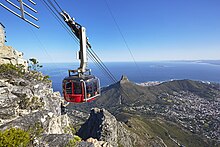
- Mountain of the Table (Table Mountain) (Reachable with the cable car (Table Mountain Aerial Cableway) which starts from 3 Tafelberg Road).
Shopping
- 1 The Old Biscuit Mill, 375 Albert Rd, ☎ 27 21 447 8194.
How to have fun
Tickets for sporting events can also be purchased online at the ticket office Compu ticket[link not working] fully automated. Ticket offices are located on Adderley Street (Waterfront), at Sea Point's Adelphi Center and other locations.
Shows
- 1 Artscape Theater Center.
- 2 Maynardville Open-Air Theater.
- 3 Cape Town Stadium.
- 4 Newlands Cricket Ground.
Night clubs

- 5 Aces' n Spades, 62 Hout Lane, ☎ 27 21 424 1620.
- 6 Alexander Bar, Café & Theater, 76 Strand St, ☎ 27 21 300 1088.
- 7 Asoka Restaurant, Bar and Lounge, 68 Kloof St, ☎ 27 21 422 0909. Mon-Fri 07: 30–04: 00, Sat 09: 00–04: 00, Sun 09: 00–02: 00.
- 8 Beerhouse, 223 Long Street, ☎ 27 21 424 3370.
- 9 Bob's Bar, 187 Long St, ☎ 27 21 424 3584.
- 10 Harringtons Cocktail Lounge, 61B Harrington St, ☎ 27 21 461 2276.
- 11 [link not working]Orphanage Cocktail Emporium, 227 Bree St, ☎ 27 71 534 0266.
- 12 Shimmy Beach Club, 12 S Arm Rd, V & A Waterfront, ☎ 27 21 200 7778.
- 13 The Dubliner, 251 Long St, ☎ 27 21 424 1212. Irish pub.
- 14 The Gin Bar, 64A Wale St, ☎ 27 71 241 2277.
- 15 The Piano Bar, 47 Napier St, ☎ 27 21 007 5212.
- 16 The Power & The Glory, 13d Kloof Nek Rd, ☎ 27 21 422 2108.
- 17 The Village Idiot, 32 Loop St, ☎ 27 21 418 1548.
- 18 Cafe Manhattans, 74 Waterkant, ☎ 27 21 421 6666. Gay club
- 19 Crew Bar, 30 Napier St, ☎ 27 78 954 8764.
Where to eat
Moderate prices
- 1 Addis in Cape Ethiopian Restaurant, 41 Church Street (Almost on the corner of Long St - City Bowl), ☎ 27 21 424 5722.
- 2 Clarke's Bar & Dining Room, 133 Bree St, ☎ 27 87 470 0165.
- 3 Fork Tapas & Pinchos Bar, 84 Long St, ☎ 27 21 424 6334. Basque / Spanish cuisine restaurant with an African touch.
- 4 GOLD Restaurant, 15 Bennett St, ☎ 27 21 421 4653.
- 5 The Hussar Grill Mouille Point, 163 Beach Road (Green Point).
Average prices
- 6 Burger & Lobster, 105 Bree Street, ☎ 27 21 422 4297.
- 7 SeaBreeze Fish & Shell, 213 Bree St, ☎ 27 74 793 9349. Seafood restaurant.
Where stay
Moderate prices

- 1 SUN1 Foreshore (former Formula 1 Hotel), 17 Jan Smuts Street (Martin Hammerschlag Way Corner), ☎ 27 21 418 4664, fax: 27 21 418-4661.
Hostels
- 2 [link previously not working]33 South Backpackers, 48 Trill Road ("Observatory" train station), ☎ 27 21 447 2423, fax: 27 21 447 2423, @[email protected].
- 3 A Sunflower Stop Backpackers, 179 Main Road (Green Point), ☎ 27 21 434-6535, fax: 27 21 434-6501, @[email protected].
- 4 African HeART BAckpackers, 27 Station Road (Observatory), ☎ 27 21 447 3125, fax: 27 86 556 0277, @[email protected].
- 5 Ashanti Lodge, 11 Hof Street (Gardens), ☎ 27 21 423-8721, 27 72 953 7363 (cell / WhatsApp), @[email protected].
- 6 Carnival Court Backpackers, 255 Long Street, ☎ 27 21 423 9003, @[email protected].
- 7 Cat and Moose Backpackers, 305 Long Street, ☎ 27 21 423-7638, @[email protected].
- 8 Green Elephant Backpackers, 57 Milton Road (Observatory), ☎ 27 21 448-6359.
- 9 Long Street Backpackers, 209 Long Street (City Bowl), ☎ 27 21 423-0615, fax: 27 21 423-1842, @[email protected].
- 10 never @ home Cape Town, 107 Main Rd (Green Point), ☎ 27 21 434 9282.
- 11 The B.I.G Backpackers, 18 Thornhill Rd (Green Point), ☎ 27 21 434 0688.
Average prices
- 12 Radisson Blu Le Vendome Hotel, 20 London Rd (Sea Point), ☎ 27 21 826 5100.
High prices
- 13 [link not working]Hilton Cape Town City Center, 126 Buitengracht St, ☎ 27 21 481 3700.
- 14 Radisson RED V&A Waterfront, Silo Square, ☎ 27 87 086 1578.
Safety
.jpg/220px-CCID_Public_Safety,_Cape_Town_(P1050988).jpg)
Common crime in South Africa is widespread mainly in large cities (in particular Johannesburg, Pretoria and Durban; the situation is relatively better in Cape Town, but still requires an adequate level of vigilance) and has, in recent times, reached very high levels. Cases of violence against tourists (thefts, assaults, murders, robberies, car hijackings, etc.) are not uncommon. It is therefore essential to strictly observe precautionary measures. In particular, pay particular attention, especially in Long Street, a well-known tourist destination and area of clubs and entertainment venues. In general, avoid less frequented areas such as secluded beaches, mountain trails and the like.
Since 2015, Cape Town has been suffering from an emergency crisis due to a prolonged drought resulting in frequent interruptions to the water supply during the day.
How to keep in touch
Around
Atlantic Seabord


.JPG/220px-Cape_of_Good_Hope_(Zaian_2008).JPG)
To the south of Sea Point lie the localities of the eastern slope of the Cape peninsula. The high, rugged coastline is known as the "Atlantic Seaboard" and is renowned for its fine sandy beaches. However, the water temperature is freezing even in the height of summer. Below is a list of the places that meet along the road that runs along the western side of the Cape peninsula ending, after about sixty km, at the Cape of Good Hope:
- 4 Camps Bay - The place to go for a drink at sunset time. Sandwiched between the mountains and the sea, it is an area that is popular thanks to the nightclubs that are arranged on the palm-fringed promenade.
- 5 Clifton - One of the most exclusive neighborhoods in Cape Town consisting of luxury villas and condominiums that dominate the beaches below.
- 6 Hout Bay —
- 7 Kommetjie —
- 8 Noordhoek —
The eastern side of the Cape Peninsula and False Bay


Of the numerous suburbs that stretch along the M3, Constantia deserves a mention for its production of wines made from the vineyards that line the eastern slopes of Table Mountain.
The M3 then reaches False Bay, the wide bay south of the center so called because in the past sailors often made mistakes and dropped anchor convinced they had reached Table Bay.
- 10 Simon's Town —
- 11 Boulders Beach - One of the most popular beaches in Cape Town, also famous for hosting a colony of penguins.
- 12 Glencairn —
- 13 Fish Hoek —
- 14 Kalk Bay —
- 15 Muizenberg —
- 16 Strand —
- 17 Gordon's Bay —
- 18 Pringle Bay —
The Winelands
52 km from the center in an easterly direction stands 19 Stellenbosch, the first of the localities of Lands of Wine (Winelands), a famous tourist-wine route on the outskirts of Cape Town. Of the Winelands it's part 20 Franschhoek, reachable from Stellenbosch via the Helshoogte mountain pass or directly from the center via the more convenient N1 motorway.