
| South Dakota | |
 | |
| location | |
 | |
| Flag | |
 | |
| Main information | |
| Capital city | Pierre |
| Currency | U.S. Dollar |
| Surface | 199 905 |
| Population | 754 844 |
| Tongue | English |
| Time zone | Central: UTC-6 / -5 Mountain: UTC-7 / -6 |
| Time zone | Central: UTC-6 / -5 Mountain: UTC-7 / -6 |
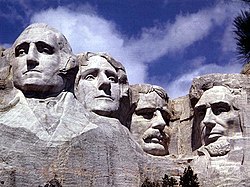
South Dakota - state in the central-northern part Of the United States, in the area of the Great Plains. It neighbors from the north with the state North Dakota, from the west with Montana and Wyoming, from the south with Nebraska, from the east with Minnesota and Iowa. The relief is generally upland, with deeply indented valleys of the Missouri River and its tributaries. In the west, the Black Hills with the highest peak Harney Peak (2207 m above sea level).
Characteristic
Geography
Counties in South Dakota: Aurora Beadle Bennett Bon Homme Brookings Brown Brule Buffalo Butte Campbell Charles Mix Clark Clay Codington Corson Custer Davison Day Deuel Dewey Douglas Edmunds Fall River Faulk Grant Gregory Haakon Hamlin Hand Hanson Harding Hughes Hutchinson Hyde Jackson Jerauld Lincoln Jonesbury Lake Lawrence Lyman Marshall McCook McPherson Meade Mellette Miner Minnehaha Moody Pennington Perkins Potter Roberts Sanborn Shannon Spink Stanley Sully Todd Tripp Turner Union Walworth Yankton Ziebach
Climate
History
Policy
Economy
Drive
By car
By plane
By ship
Cities
Interesting places
Transport
Shopping
Gastronomy
Accommodation
Security
Health
contact
| This is outline article. For now, it includes the article schema and not much else. You can help by supplementing the article with at least basic information, making it useful. |