| Damaraland | |
 | |
Location  | |
Flag | |
| State | Namibia |
|---|---|
| Surface | 47,990 km² |
Damaraland is a region of the Northern Namibia.
To know
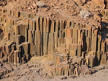
South of the Kaokoland there is the land of the Damara, a heavily eroded plateau, dotted with craters and granite formations with often imaginative shapes such as the Vingerklip in which an index finger turned towards the sky was recognized. The highest peak not only of Damaraland but of the whole Namibia it is Mount Brandberg which reaches 2,600 m. Its name means "Mountain of fire" and was given to it by the Boer settlers who were struck by the bright colors that the massif takes on at sunset. The area is full of prehistoric stone paintings generally attributed to the Bushmen. To see the most famous of these paintings, the "White Lady" is required by law to be accompanied by a specialized guide. Rock engravings are present in Twyfelfontein, a site that appears on the list of World Heritage Sites.
Territories and tourist destinations
Urban centers
- Aub Canyon
- Doro Nawa Conservancy
- Khorixas - Main city of Damaraland.
- Twyfelfontein - Valley where paintings and rock engravings of the Stone Age have been found.
- Uis - Village near the Brandberg massif.
Other destinations
- Messum crater - Crater of an inactive volcano.
How to get
How to get around
What see
What to do
At the table
Safety
Where stay
- Doro Nawa Lodge (Twyfelfontein area). On the edge of the reserve of the same name, the Doro Nawa Lodge is one of the most beautiful places to stay overnight. Accommodation in tents is comfortable. For once, the comments on the web agree that the Doro Nawa Lodge is a magnificent place.
- Fort Sesfontein Lodge and Safaris, ☎ 264 65 685 034, fax: 264 65 685 033.
- Mowani Mountain Camp (Twyfelfontein area), ☎ 264 61 232 009, fax: 264 61 222 574.
- Twyfelfontein Country Lodge, ☎ 264 61 374750.
- Brandberg Rest Camp (Uis village). The camping area is equipped with electricity. Campers have free access to the swimming pool.
- Brandberg White Lady Lodge, ☎ 264 64 684004.
- Palmwag Rhino Camp.
- Grootberg Lodge (23 km from Palmwag on the road to Kamnjab), ☎ 264 61 246 788, 264 67 687 043, fax: 264 61 243 079. In a panoramic position over a valley.
- Huab Lodge (Kamanjab area), ☎ 264 67 687058, fax: 264 67 687059.
- Hobatere Lodge (Kamanjab area).
- [link not working]Camp Xaragu (Khorixas area), ☎ 264 081 124 5612.
- Vingerklip Lodge, ☎ 264 67 290 319, 264 67 687 158, 264 61 255 344 (Windohek).
Other projects
 Wikipedia contains an entry concerning Damaraland
 Commons contains images or other files on Damaraland