| Northern Namibia | |
 | |
| State | Namibia |
|---|---|
Northern Namibia is the region extended up to the border with theAngola.
To know
This territory is the most developed and rich in attractions. The region is diverse both in natural and ethnographic terms from west to east, ie from the sea to the border with Botswana. The barren coastal strip known as Coast of Skeletons National Park, it is practically closed to the public. To the east lies a beautiful area with ancient mountains, the most interesting part of which is the Damaraland. It may be interesting to visit the region of Kaokoland where the tribe of the hibma. Further east in another mountain landscape you can see the gods tribe Herero and the Bushmen. Finally here is the pearl of Namibia: the Etosha National Park.
Its northernmost portion was known as Ovamboland under the regime South African. Northern Namibia is divided into several administrative regions. It is the most densely populated area (although still predominantly rural), and home to the Ovambo, the largest ethnic group in the Namibia.
Geographical notes
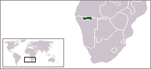
Northern Namibia is a region that roughly extends from the mouth of the Ugab River to the border with Angola bordered by the Kunene River.
Suggested readings
- Heinrich Vedder, South West Africa in Early Times. Being the story of South West Africa up to the date of Maharero's death in 1890. Cass & Co. London 1966 - Part 1: Namaland, Hereroland and Ovamboland, Chapter 1: Discovery and Exploration, pages: 18-40
Territories and tourist destinations

Urban centers
- Grootfontein - From the colonial air, Grootfontein (Big Spring) is the place where "Hoba" was found, the heaviest iron meteorite ever to fall on Earth.
- Khorixas - The major center of the Damaraland.
- Okahandja - A center inhabited mainly by Herero people, Okahandja is worth a stop for its huge artisan market which is held at the intersection of the B1 with the B2, the artery that ends in Swakopmund, city on the coast founded at the time of German rule.
- Omaruru - A dusty place which however forms the basis for excursions to the nearby Erongo Mountains.
- Ondangwa - Located in a flat and monotonous region, sprinkled with pan formed after particularly heavy rains, Ondangwa is a center of no interest except for a 19th century missionary house now transformed into a small museum.
- Oshakati - The capital of the Oshana region.
- Oshikango - The last village of the Namibia before the border crossing with theAngola.
- Otavi - Otavi is famous for the battle of 1 July 1915 in which the British army defeated the German one, thus putting an end to the colonial experience of the Germanic empire on African soil.
- Otjiwarongo - A town with no interest except, perhaps, for a steam locomotive on display in the railway station building and for the Crocodile Ranch where Nile crocodiles are bred with the not so noble purpose of obtaining bags and other clothing for European markets and Americans.
- Rundu - Muggy place, Rundu is uninteresting but can be a stop on the journey. Rundu is the administrative capital of the Kavango region. It is crossed by the Okavango River which then flows into a series of swamps in Botswana. Many lodges are located on the banks of the river.
- Tsumeb - Close to the main entrance gate to the Etosha National Park, Tsumeb is a nice place, famous for its mines and two natural lakes in the surroundings.
- Uutapi - Capital of the Omusati region.
Other destinations


- Ruacana waterfalls
- Coast of the Skeletons - The coast is accessible from Swakopmund via the C34, a particularly slippery coastal road that passes through Cape Cross and Torra Bay. It owes its name both to the wrecks of ships stranded on the coast and to the whale skeletons found in the nearby desert. A key point on the coast is Cape Cross, a marine reserve established in 1968 to protect the largest seal colony inhabiting this coastline, access to which is severely restricted.
- Messum crater - Offers spectacular desert landscapes.
- Damaraland - Damaraland is a magnificent land renowned for its landscapes. From Windhoek is accessible by passing through Outjo. From here to Khorixas, major regional center are 130 km. Along this last stretch there are strange rock formations among which the most famous is the Rock finger in the shape of a finger pointing towards the sky.
- Kaokoland (Kaokoveld) - Kaokoland is the land of the Himba. Despite the shortage of roads it has a certain tourist flow. From Windhoek until Opuwo, the largest regional center, the shortest road passes through Outjo is Kamanjab. In all, there are 710 km.
- The White Lady - World famous rock painting located in Brandberg massif.
- Brandberg massif - The highest mountain in Namibia (2,573 m).
- Mount Burnt - The name (monte "arso") becomes evident when observed in the early morning or late afternoon.
- Mount Goboboseb - Small mining excavations to look for crystals such as: rose quartz, amethyst, etc.
- Organ Pipes - Rock columns (diabase) in a conformation that makes them similar to the pipes of a large organ.
- Etosha National Park - From Otjiwarongo the road to Outjo which then continues to the Anderson gate, one of the entrance gates to the Etosha National Park. Outjo housed a military garrison at the time when Namibia was a German colony. The barracks have been transformed into a small museum. The Etosha National Park extends for 22,000 km² but only a small part of it is open to the public. Etosha is a place of swamps interspersed with saline deserts where a varied fauna finds refuge. Its name in the language of the Ovambo tribe means "great white space" or "place where nothing grows". Here you can see many of the traditional animals without any problems South Africans that roam the territory in huge herds of antelopes, zebras and giraffes, but for the most interesting and important animals, including predators and rhinos, more time and patience are needed.
- Waterberg Plateau National Park - It hosts an extremely rich ecosystem with abundant fauna.
- Twyfelfontein - The largest repository of San art in the country dating back to 6,000 years ago, as well as one of the World Heritage Sites in Namibia. Quiet and isolated place in the region of Damaraland, in the heart of the rocky desert in the Ugab river valley. It can also be visited in a hot air balloon to observe flora and fauna of the desert, including desert elephants, whose very existence has for some time aroused suspicion.
- Vingerklip - A rock pinnacle with a seemingly unstable balance.
How to get
How to get around
By car
If you travel during the dry season, a common sedan is more than enough for your travels. To visit the most remote corners of the Kaokoveld, you will need a sturdy 4X4 and the necessary expertise to drive it.
By bus
If you don't have a car, you can board one of the comfortable coaches of the bus lines Intercape Mainliner, which they connect Windhoek with Victoria Falls (beyond the border) crossing all the centers located on the "B1" and "B8".
What see
Itineraries
Along the "B1 Road"
Once you have exited the capital and once you have taken the "B1 road" you will find the following centers: Okahandja (70 km), Otjiwarongo (250 km), Otavi (368 km), Tsumeb (433 km), Ondangwa (681 km), Oshikango (742 km), Oshakati is Uutapi. In brackets the distances from the capital.
On branches of the B1
You meet the Etosha National Park is that of Waterberg. The Damaraland, Kaokoland and the Costa degli Skeletons.
An east branch leads after 138 km to Kalkfeld e Omaruru. At 23 km from the center are the dinosaur footprints. Otjozondjupa Tsumkwe region and surroundings. After which it deviates inland, reaching Khorixas with 210 km for challenging roads that go up the mountain ridge. It extends from the city of Swakopmund up to the borders withAngola. It is a sandy desert with no water. The northern area is a national park. The stretch of southern coast of the Skeleton Coast up to Torra Bay constitutes a protected area known as the "National West Coast Tourist Recreation Area" granted in concession by the Namibian government to the Wilderness-safaris, a private company that manages other territories in Southern Africa. To access it with your own vehicle you need a permit from "Namibia Wildlife Resorts".
On the route of the B8 Road
There B8 Road it is an entirely asphalted major artery. It starts from Otavi and then runs through the region of Caprivi's finger up to the border crossings with Botswana is Zambia allowing easy access to the Chobe National Park and at Victoria Falls. Possible stages along its path are: Grootfontein is Rundu.