| Jebel Dahar ((ar)جبال الظاهر) | |
 | |
| The surroundings of Matmata | |
| Information | |
| Country | |
|---|---|
| Region | Tunisian Sahara |
| Area | 6 500 km² |
| Rocks | sandstone, limestone |
| Age | 140 million years |
| Location | |
 33 ° 23 ′ 30 ″ N 10 ° 8 ′ 0 ″ E | |
the Jebel Dahar is a mountain range of Tunisian Sahara.
Understand
The chain starts north of Matmata and meanders during, approximately, 250 kilometers along a north-south axis up to Dhehiba, just before the Libyan border, where it takes a west-east axis and the name of Djebel Nefoussa.
To go
Coming from the northern part of Tunisia, join the highway A 1 أ until Gabes then take the national road RN 1 ط و until Medenine. Of the,
- either take the national road RN 20 ط و in the direction of Matmata,
- either take the national road RN 19 ط و in the direction of Tataouine.
Circulate
Between Matmata and Dkhilet Toujane, the Jebel Dahar is crossed by the national road RN 20 ط و
Between Tataouine and Remada, it is crossed by the national road RN 19 ط و and between Remada and Dhehiba, it is bordered to the north by the regional road RR 112 ط ج.
Apart from these three communication routes coated with asphalt concrete in very good condition, the other roads and paths are unpaved tracks, for the most part rocky.
City
- 1 Matmata (مطماطة) – Small village of about 2,000 inhabitants where there are about ten hotels. The New Matmata which counts approximately 7,500 inhabitants is located at 15 kilometers to the north and has many restaurants, a bank, a post office and two gas stations.
- 2 Tataouine (تطاوين) – City of approximately 67,000 inhabitants which has all the infrastructure to properly accommodate travelers. Being also the most central city of the djebel, it constitutes an excellent base camp to radiate.
- 3 Remada (رمادة) – Small town of about 6,500 inhabitants. There are a few places to eat, food stores, a hospital, a pharmacy, two gas stations and a hotel.
- 4 Dhehiba (الذهيبة) – Small town of about 4,500 inhabitants situated at 4 kilometers of the Libyan border. There are a few restaurants, grocery stores, a pharmacy and a gas station, but no hotels.
Other destinations
The climax :
- 1 Djebel Zemertene –
 The highest point of Jebel Dahar at 731 meters is quite difficult to access. From Matmata or from Medenine, follow the national road RN 20 ط و until Dkhilet Toujane (دخلت توجان) then take the track to the village of Zmerten (زمرتين) and at the exit of the village, take the first track on the left to the viewpoint parking lot.
The main attraction is the visit of at least one ksar :
- 2 Ksar Hadada (قصر حدادة) – It's in the hotel Ksar Hadada that part of the film was shot Star Wars Episode I: The Phantom Menace to represent Mos Espa on the planet Tatooine.
- 3 Chenini (شنني) – One of the best preserved and most spectacular ksour at the top of its promontory, the oldest parts of which date from the XIIe century. Some ghorfas have been renovated and transformed into a hotel.
- 4 Douiret (دويرات) – Ksar "ghost" where we find the only underground mosque in Tunisia accessible to non-Muslims and where the few remaining inhabitants have built their houses at the foot of the ksar.
- 5 Ksar Ouled Debbab (قصر أولاد دباب) – Partly restored, this part is transformed into a hotel. One of its advantages is that it is located along the national road 19.
- 6 Ksar Ouled Soltane (قصر أولاد سلطان) – It covers a rectangular area of sixty by forty meters open by a single entrance. Completely restored, it is the ksar, which with a number of 400, has the most ghorfas. It is also distinguished from other ksour by its large number of exterior stairs glued to the masonry and the presence of wooden hooks used to hoist the goods. Another scene from Star Wars Episode I: The Phantom Menace was shot here. the , Tunisia proposed the site to be included on the UNESCO World Heritage List.

In the hotel Ksar Hadada.
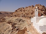
Chenini.
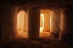
In the Douiret mosque.

The renovated part of Ksar Ouled Debbab.

Ksar Ouled Soltane.


Do
To buy
Eat
Have a drink / Go out
Housing
Around
- 1 Medenine (مدنين) (to North-east)