 East side of the Jabal al-Barkal | ||
| Jebel al-Barkal · جبل البركل | ||
| State | Shamālīya | |
|---|---|---|
| height | 287 m | |
| no tourist info on Wikidata: | ||
| location | ||
| ||

The Jebel al-Barkal, also Gebel / Jebel / Gabal / Jabal / Mount (al- / el-) Barkal / Berkel / Birkel, Arabic:جبل البركل, Jebel al-Barkal, on the spot even after a local sheikh Jebel Vad al-Karsanī, جبل ود الكرسني, Called, is a mountain and an archaeological site in North Sudan in the Sudanese State ash-Shamālīya. It is located on the western bank of the Nile, about 400 kilometers north of al-Charṭūm and north of the small town Marawī and immediately southeast of the small town Karīma. The archaeological site has been a UNESCO World Heritage Site since 2003.
background
history

The ancient Egyptian king Thutmose III., the 6th king of the 18th ancient Egyptian dynasty in the New Kingdom, could expand his sphere of influence to the Jabal al-Barkal after a campaign in Nubia. Since then, the Egyptians have considered the mountain sacred. They believed that the god Amun lives in the mountain.
Research history
getting there
By plane
The closest airport is the 1 Merowe Airport![]()
![]() (IATA: MWE). There are probably no scheduled flights to this airport.
(IATA: MWE). There are probably no scheduled flights to this airport.
By train
The nearest train station is in Karīma. However, trains rarely run.
By bus
The closest bus station is in Karīma.
In the street
mobility
The archaeological site can only be explored on foot. The subsoil is sandy. A visit to the site is not possible for people with restricted mobility or only with great effort.
Tourist Attractions
Jebel al-Barkal
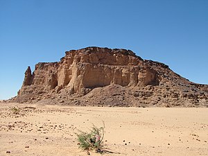
The 1 Jebel al-Barkal is a 98 meter high table mountain (above ground) with partly steep slopes. In the south rises an almost free-standing, 75 meters high 2 Rock needle up. The ancient Egyptians saw it as a statue in the form of a Uraeus snake.
The ascent to the mountain can be done in the area of the northern pyramid group because the slope is less steep here. The easiest way down is in the field of 3 sand dune possible.
Temple and palace district


- 4 Amun temple (B.500) (18 ° 32 '7 "N.31 ° 49 ′ 50 ″ E)
- 5 Hathor Mut Temple (B.300) (18 ° 32 ′ 5 ″ N.31 ° 49 ′ 44 ″ E)
- 6 palace (B. 1500) (18 ° 32 ′ 10 ″ N.31 ° 49 ′ 57 ″ E)
Pyramid cemeteries
museum
- 9 al-Barkal Museum (متحف البركل)


 in the Wikidata database") (18 ° 32 '23 "N.31 ° 49 ′ 51 ″ E)
(18 ° 32 '23 "N.31 ° 49 ′ 51 ″ E)

Tomb of Aḥmad al-Karsanī
- 10 Tomb of Aḥmad al-Karsanī (أحمد الكرسني). The grave, which was built at the end of the 19th / beginning of the 20th century, is a rectangular building made of stone and is still visited by Muslims for prayer today.(18 ° 32 ′ 3 ″ N.31 ° 49 ′ 40 ″ E)
activities
Watching the sunset.
kitchen
There are restaurants in Karīma and Marawī.
accommodation
Accommodation is available in Karīma and Marawī.
health
Medical care can be in Marawī and Karīma be made.
Practical advice
literature
Web links
- Gebel Barkal, History and Archeology of Ancient Napata