 Dimai archaeological site | ||
| Dīmai es-Sibāʿ · ديميه السباع Soknopaiou Nēsos · Σοκνοπαιου Νῆσος | ||
| Governorate | Faiyūm | |
|---|---|---|
| height | 24 m | |
| no tourist info on Wikidata: | ||
| location | ||
| ||

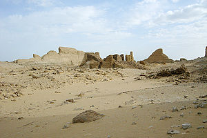
Dimai es-Siba ' (also Dime, Dimeh, Dimayh, Arabic:ديمية السباع, Dīmai as-Sibāʿ, „Dīmai of the lions“, Orديمى السباع, Greek: Soknopaiou Nēsos) is an archaeological site in Faiyūm in Egypt, about 3 kilometers north of the Qārūn Lake and 35 kilometers west of Kōm Auschīm. Since the city from Greco-Roman times was never repopulated after it was abandoned in the middle of the 3rd century AD, its state of preservation is quite good. After excavations in the first years of the 21st century, the temple has now been exposed. Egyptologists and archaeologists should be mainly interested in this site.
background
The archaeological site 1 Dīmai es-Sibāʿ(29 ° 32 ′ 2 ″ N.30 ° 40 ′ 9 ″ E) is located on the north side of the Qārūn Lake, about 3 kilometers from its shore, 8 kilometers south of 2 Qaṣr eṣ-Ṣāgha(29 ° 35 '42 "N.30 ° 40 ′ 40 ″ E) and about 35 kilometers west of Kōm Auschīm away. The site is now surrounded by a stone and sand desert. The stony subsoil consists of limestone, which is partially interspersed with fossils. The alternative Arabic place name used in the past Medinet el-Nimrud is not known these days. The name addition es-Sibāʿ, the lions, reflects the former access route to the city's temple, which was lined with reclining lion figures. These lion figures had almost disappeared by the middle of the 19th century.


Due to the numerous found here, written in Greek or in Demotic, in ancient Egyptian cursive Document texts we are now quite well informed about the ancient city of Soknopaiou Nēsos. These papyri give an insight into the economic life of the temple and the settlement and also describe the daily temple rituals.[1] Despite the extensive papyrus finds, the city was hardly systematically investigated archaeologically until the beginning of the 21st century and even less documented, although the conditions for the archaeologists were favorable due to the preservation in the desert climate and the lack of new settlements.
The ancient city Soknopaiou Nēsos (Greek Σοκνοπαιου Νῆσος, the "Island of Soknopaios") was founded in the middle of the 3rd century BC. At the time of the king Ptolemy II Philadelphus (Reigns 285–246 BC) in the Arsinoites Gau newly created by the Greeks, today's el-Faiyūm. The name was derived from that of the local crocodile god Soknopaios, "Sobek, lord of the island" (ancient Egyptian Sbk nb P3-jw), from. One of the earliest documents to mention this city is the papyrus pill 1.3, who died around 216/215 BC. Was written.[2] An earlier settlement is quite conceivable. In the vicinity of the city, especially in the north and northwest, the scientists of the most recent Italian research mission found ceramic fragments that date back to the ancient Egyptian old and new empires as well as the late period.
The city was built on a hill, is 640 meters long from north to south, 320 meters wide from west to east and occupies about 23 hectares. The first buildings were laid out in the northwest of the area. Over time, the city expanded more and more to the southeast. The approximately 400-meter-long access road led through the city to the temple, dividing the city into two halves, the eastern half being the larger. The city was laid out according to plan. Their streets cross at right angles.
The city had repeatedly experienced ups and downs. So far, four layers of settlement have been identified. The reign of the king was one of the heyday Ptolemy VI Philometor (Reigns 180 to 145 BC) and the Roman period in the first and second centuries AD. It is believed that the city was abandoned in the middle of the 3rd century because no later text documents could be found. The causes could have been the advance of the desert as well as the silting up and salinization of the Qārūn Lake.
To the economical boom On the one hand, the fact that the city was at the beginning of a caravan route contributed to it. On the other hand, agriculture was also practiced here on irrigated fields. Especially in Roman times, these lands, but also cattle and other production facilities belonged to the local temple.
In the temple complex, which is still visible from afar, the Crocodile god Soknopaios, “Sobek, Lord of the Island”, venerated. He represented a local form of the Sobek and was depicted as a crocodile with a falcon's head. The cult of Soknopaios was similar to that of the goddesses Isis Nepherses ("beautiful Isis")[3][4] and Isis Nephremmis (probably "Isis with the beautiful hand")[5] connected. Finds also document the equestrian god Heron, who was unknown in ancient Egypt.

The German Egyptologist was the first European to visit Karl Richard Lepsius (1810-1884) visited the city on July 6 and 7, 1843, leaving a brief description, plan and two views. He also mentioned abandoned burial mounds and statuettes from the graves. As elsewhere, the crumbled adobe buildings on the site were called Sibach, as fertilizer, used by the locals, even before Lepsius visited. During excavations of this kind, papyri came to light in 1870 and 1887. Because of these papyri, “excavations” for antique dealers were approved in 1890–1891 and 1894. 1900-1901 were here on behalf of the Egypt Exploration Fund by the British Bernard Pyne Grenfell (1869-1926) and Arthur Surridge Hunt (1871–1934) explorations carried out.[6] From 1908–1909 the Germans stayed here Friedrich Zucker (1881-1973) and Wilhelm Schubart (1873–1960) to order papyri and ostraka for the papyrus collection of the Royal Museums in Berlin[7], labeled shards of stone. Today papyri from Soknopaiou Nēsos can be found in major museums such as the Louvre in Paris, but also in Lille[8], Berlin, Vienna and Manchester[9].
The finds in the temple district included a relief with crocodiles, a statue of the Hereditary Prince Sobekhotep (Museum Berlin, inv.no.11635), statues and statue fragments of priests (several in Berlin) and the upper part of the statue of a king (Museum Kairo, CG 702).[10][11]
From 1931–1932, Enoch E. Peterson (1891–1978) from Michigan University led here Ann Arbor carried out the most extensive research up to then, especially in the urban area, which was only partially published. Ceramics, furniture, agricultural implements, fishing tools, coins, papyri and ostraka were found in the houses. The walls were partially painted on white plaster. The motifs also included crocodiles.
In 2001 and 2002 a joint survey was carried out by the Universities of Lecce and Bologna under the direction of Mario Capasso and Sergio Pernigotti. They have had an excavation license since 2004. The focus of research, which has now been going on for a decade, is the temple precinct. The finds included numerous Greek and demotic papyri and ostraka, but also bronze coins from Greek and Roman times, a fragment of a bronze statue of a leopard and several statues, mostly of priests. Among the statues there was also the 1.7 meter high statue of a woman who was sure to represent the goddess Isis. The ceramic finds in the settlement date from Roman and Byzantine times. In 2011 robbery excavations were discovered, as a result of which reliefs were brought into the magazine.
The project is now being carried out with international participation from the University of Würzburg, University of California in Berkeley and the Università Statale in Milan carried out.
getting there
The visit to Dimai should be done with the nearby archaeological site of Qaṣr eṣ-Ṣāgha get connected. Both sites are about 7 kilometers apart as the crow flies. To visit both sites, you officially need a permit from the Supreme Antiquities Authority in Cairo!
Both sites are in the desert, so you definitely need an all-terrain, all-wheel drive vehicle or a pickup. The subsoil can be limestone rock, but also sandy. Since there is nothing en route, the tank should be full. A satellite phone does no harm. Due to the remoteness, you cannot count on help from passers-by. In any case, the driver should be familiar with the area.
Of Cairo Coming from you drive around Kōm Auschīm in the North. One can at 1 29 ° 34 '49 "N.30 ° 56 ′ 28 ″ E Turn west off the Cairo-el-Faiyūm highway. The slope is about six kilometers long and then disappears into nothing. From the end of the piste you reach Qa inr eṣ-Ṣāgha after about 20 kilometers in a westerly direction, and after another eight kilometers in a southerly direction Dimai. The walls of the temple complex of Dimai can be seen from afar. It takes about an hour and a half to cover a distance.
In the case of arrival via Kōm Auschīm you could be accompanied by police officers.
An alternative way to get here is from the village 1 Qarun(29 ° 24 '53 "N.30 ° 23 '17 "E) from that one about the Wādī er-Raiyān can reach. In the west of the village one branches off 2 29 ° 24 '55 "N.30 ° 22 ′ 55 ″ E to the north and drive east at the village of ʿAlāʾ Miftāḥ Marʿī 2 ʿAlāʾ Miftāḥ Marʿī(29 ° 26 ′ 33 ″ N.30 ° 22 ′ 56 ″ E), Arabic:علاء مفتاح مرعى, Over. The road now changes its direction to the east in a wide arc. About in the area of the next village on the south side of the road one branches off 3 29 ° 26 '49 "N.30 ° 23 '53 "E north on the road that runs north of the Qārūn Lake ties up. This junction can also be reached from Shakshuk if you drive about 33 kilometers along the coastal road to the west.
The road to the west and north of Lake Qārūn is paved. About 21.5 kilometers after the village of Qārūn one branches off 4 29 ° 29 ′ 41 ″ N.30 ° 31 '44 "E from this road on the dirt road in a north-easterly direction. This piste is easy to spot, even if you can hardly see the piste after a long kilometer, about half a kilometer. The piste is even paved for a short distance. On this slope you drive about 14.5 kilometers, branches off 5 29 ° 33 '17 "N.30 ° 39 '49 "E to the south and after about 2.5 kilometers you reach Dimai. After the inspection, you return to the piste and continue on it for another 5 kilometers in a north-easterly direction to about 6 29 ° 34 '40 "N.30 ° 41 ′ 17 ″ E. After about 2 kilometers in a north-northwest direction one reaches Qaṣr eṣ-Ṣāgha. It also takes an hour and a half to cover a distance.
In principle, too Boat crossing from Shakschūk over the Qarun Lake possible. Fishermen who know the way across the lake can certainly be found. From the bank you have to walk about 3 kilometers. Experienced hikers can also manage the next 7 to 8 kilometers to Qaṣr eṣ-Ṣāgha.
mobility
The archaeological site can only be explored on foot.
Tourist Attractions
Dromos

The main entrance to the city and the temple was in the south. A 400 meter long dromos, a corridor paved with stone slabs, led to the temple complex in the northwest of the city. This street was once lined with lions on both sides, from which the name was added es-Sibāʿwho have favourited lions, still remembered today. Already in the middle of the 19th century there was hardly anything left of the lions. The Egyptologist Lepsius only reported the discovery of a paw of a sphinx and part of a lion's head with a mane. As part of the Italian excavations at the beginning of the 21st century, it has so far been possible to reconstruct such a lion figure from numerous fragments.
settlement
The ancient city extends to the south and southeast of the temple area, which is visible from afar. The city was planned like on a drawing board. The individual streets cross at right angles.
The houses were called so-called. insulae created. The residential buildings made of air-dried mud bricks were grouped around a common inner courtyard. These courtyards were used as stables, but also for flour grinding, cooking and baking in clay ovens. Stairs led to the basement where the grain was kept.
Several public and administrative buildings also belong to the city, but their individual function is not yet known.
Temple precinct


In the northwest of the city, visible from afar, the approximately 1 hectare large temple area rises. His Enclosing wall made of air-dried clay bricks measures around 120 × 85 meters, is up to 5 meters thick and is up to ten meters long. It is believed that this wall could once have been up to 15 meters high. The main entrance of the district is on the southern narrow side at the end of the 400 meter long drom. Another entrance is on the north side of the district.
The district is largely covered by the Temple for the crocodile god Soknopaios, for “Sobek, Lord of the Island”, filled in. It was built in Ptolemaic, i.e. Greek, times. The temple was built in two stages. First, the southern, 32-meter-long part of the building was built as an independent temple. After the temple was expanded to the north, the earlier temple was used as a monumental propylon, as a vestibule. The temple was built from local limestone with a yellowish or gray-white color. Air-dried bricks were used for the side buildings and walls. After the decline of the city, the temple was looted by stone robbers, so that the stone walls are only between one and two meters in length today.
You entered the temple in the south. Its entrance is exactly opposite the main entrance in the surrounding wall. The once independent sanctuary served as a propylon after the temple was expanded and is 18.9 meters wide and 32.5 meters long - in the current excavations this part of the temple is called ST18. The inner walls were built from limestone blocks, of which up to seven layers, about one and a half meters, have been preserved. This part of the building was framed by side rooms and a wall made of adobe bricks. These adobe walls are still up to a height of five meters. Both the limestone and the adobe walls were partially plastered. The plaster has been preserved in some places.
The front part of the temple consisted of two rooms one behind the other with side rooms. This was followed by a transverse hall and the Holy of Holies for the cult image. After the enlargement, the Holy of Holies lost this function and it was only one of several courtyards of the enlarged temple. For this purpose, a door was also inserted in the former temple back wall.
Two more buildings were added to the northern rear wall, which were supposed to form another courtyard with side rooms after the temple was expanded, probably as early as the construction time of the southern part of the temple. The western outbuilding, called ST23, has four rooms, the eastern one, called ST200, has three rooms above and one below ground. Both buildings are about 6.5 meters long and about 5 meters wide. From these two buildings and the open space in between, a temple part about 20 meters wide and 7 meters deep was later created.
Later, but still in Ptolemaic times, the Temple extended to the north. This extension is 28 meters long, 19.3 meters wide and was named ST20 by the excavators. The interiors were exposed in 2005-2009, the outer walls in 2009 and 2010. This part of the temple was built entirely from yellow and gray limestone and is similar in shape to other temple complexes from the period, such as the significantly larger complex of Edfu. The walls of the temple are still preserved today up to a height of one and a half meters. In the rubble, fragments of architecture from higher-lying temple parts such as lintels with solar disks and cobras as well as urea friezes were also found.
The entrance to this rear part of the temple is (of course) in the south. Then you go through three halls to get to the Holy of Holies. The doors between the halls were a good two meters wide and were closed by a double-leaf door. The first hall is 8.2 meters wide, 4.15 meters long and has two side rooms each. In the west these are reached via an entrance, in the east each room has an entrance to the central hall.
A ramp leads to the next hall with a side room in the east and a staircase in the west. In this hall, remains of decorations were found on the north-west wall. These were the lower parts of nine males, including twice the king and five gods.
The following hall with a stairwell in the west and a side room in the east served as a sacrificial hall in front of the holy of holies. Remains of the wall painting of a king and a god were preserved in this hall, and stone blocks with relief were also found here.
The adjoining Naos, the Holy of Holies, consists of two rooms one behind the other. Both are 3.6 meters wide. The front room is 6.2 meters long, the back two meters long. These rooms were used to store the cult image of the god Soknopaios, but had no decoration.
The naos is surrounded by a U-shaped passage. It is 1.2 meters wide in the east and west and 0.8 meters in the north. From the west and east of the gallery you had access to three side rooms and two crypts. These rooms were used to store the liturgical utensils.
A path once also led from the north gate of the surrounding wall to the back of the temple. Remnants of a column were found near the rear wall.
In the temple area outside the temple, especially on the west side, there are more adobe buildings. They served as accommodation for the priests and as administrative buildings.
kitchen
Food and drinks must be brought along. Leftovers have to be taken back with you.
accommodation
There are hotels on the southern edge of the Qārūn Lake and in Madīnat el-Faiyūm.
trips
One can visit Dīmai with a visit to Qaṣr eṣ-Ṣāgha, the Wādī er-Raiyān and Kōm Auschīm connect.
literature
- Lepsius, Richard: Monuments from Egypt and Ethiopia, Abth. I, vol. 1, plates 52, 54, Texts, Vol. 2, pp. 35-41.
- : Karanis and Soknopaiu Nesos: Studies on the history of ancient civil and personal relationships. Vienna: Gerold, 1902, Memoranda of the Imperial Academy of Sciences in Vienna, Philosophical-Historical Class; Vol. 47, Dep. 4.
- : Soknopaiou Nesos: the University of Michigan excavations at Dimê in 1931-32. Ann Arbor: Univ. of Michigan Pr., 1935, University of Michigan studies: humanistic series; 39.
- : Dimai (Soknopaiou Nesos). In:Bard, Kathryn A. (Ed.): Encyclopedia of the Archeology of Ancient Egypt. London, New York: Routledge, 1999, ISBN 978-0-415-18589-9 , P. 309 f.
- Capasso, Mario (Ed.): Ricerche su Soknopaiou Nesos e altri studi. Galatina: Congedo, 2007, Papyrologica Lupiensia; 16, ISBN 978-88-8086-862-0 .
Individual evidence
- ↑Emmerich, Robert: Cult of the crocodile god, Science Information Service, February 3, 2009.
- ↑Jouguét, Pierre (Ed.): Papyrus grecs. Paris: Leroux, 1907. In the older literature, the papyrus was also used in the year 241/240 BC. Dated. The city was mentioned on line 20, see also pill 1.3 on papyri.info.
- ↑: Egyptian priests under Roman rule. In:Journal of Egyptian Language and Antiquity (ZÄS), vol.31 (1893), Pp. 31-42, especially p. 32.
- ↑: Real Lexicon of Egyptian Religious History. Berlin: Gruyter, 1952, P. 518.
- ↑ Bonnet, loc. cit., P. 519.
- ↑: English excavations in Faiyum 1900/01. In:Archives for papyrus research and related fields (AfP), vol.1 (1901), Pp. 560-562. — : Excavations in the Fayûm. In:Archaeological report: comprising the work of the Egypt Exploration Fund and the progress of egyptology during the year 1900-1901, 1901, pp. 4-7. — : English excavations in Fajûm and Hibeh, 1902. In:Archive for papyrus research and related fields (AfP), vol.2 (1903), Pp. 181-183.
- ↑: Demotic ostraka from Soknopaiu Nesos. In:Kramer, Bärbel; Luppe, Wolfgang; Maehler, Herwig; Poethke, Günther (Ed.): Files from the 21st international papyrology congress: Berlin, August 13-19, 1995; 2. Stuttgart, Leipzig: B.G. Teubner, 1997, Supplement / Archive for Papyrus Research and Related Areas; 3.2, Pp. 1056-1060.
- ↑: Recueil des inscriptions grecques du Fayoum; tome 1: La "Méris" d’Herakleidès. Suffer: E. J. Brill, 1975, Pp. 121-162.
- ↑: Studies in Late Egyptian Documents preserved in the John Rylands Library: II Dimê and its Papyri; an Introduction. In:Bulletin of the John Rylands Library, Manchester (BRL), vol.48 (1966), Pp. 433-466. Continued in Vol. 49 (1966-1967), pp. 464-496 and in Vol. 52 (1969-1970), pp. 218-230.
- ↑: Lower and Middle Egypt: (Delta and Cairo to Asyûṭ). In:Topographical bibliography of ancient Egyptian hieroglyphic texts, statues, reliefs, and paintings; Vol.4. Oxford: Griffith Inst., Ashmolean Museum, 1934, ISBN 978-0-900416-82-8 , P. 96 f; PDF.
- ↑: Statues and statuettes of kings and individuals in the Cairo Museum; 3: Text and plates for no. 654–950. Berlin: Reichsdruckerei, 1930, Catalog général des antiquités egyptiennes du Musée du Caire; 88, Nos. 1-1294.3, P. 44, plate 130.
Web links
- Soknopaiou Nesos Project, Italian excavation mission in Dīmai
- Dime in Fayum - a temple in the field of tension between tradition and multiculturalism in Hellenistic-Roman Egypt, Chair of Egyptology, University of Würzburg
- Dime online, Database of demotic and Greek witnesses from Soknopaiu Nesos