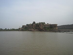
Gagron Fort
Jhalawar is in the Kota Division of Rajahstan. It used to be the capital of the eponymous princely state.
Understand
Get in
By plane
The closest passenger airports are in Bhopal, Indore and Jaipur.
By train
Jhalawar has a train station about 2km outside downtown.
- 1 Jhalawar City railway station.


By car
Jhalawar is on National Highway 52, which links Northern India with Southern India via the western states. The city is easily accessible from Jaipur and Indore, both of which also lie on National Highway 52.
Get around

Map of Jhalawar
See
- 1 Gagron Fort (गागरोन का किला). Located just outside the city, this is one of six hill forts in Rajasthan that have been inscribed on the UNESCO World Heritage List.
- 2 Shantinath Jain Temple (In Jhalrapatan, six km south). 11th century temple
- The Government museum. Displaying paintings, statues and manuscripts.
- Kolvi Buddhist caves (Kolvi village). An ancient religious complex consisting of around 50 caves.
- 3 Sun Temple (Bada Mandir), Jhalprapatan (near Badli Chabutra). An intact 11th century temple intricately made from red stone consisting of over a hundred pillars and several beautifully carved sculptures. Its architectural style is reminiscent of the temples at Khajuraho and the more notable sun temple in Konark.