| Konitsa Κόνιτσα | ||
 | ||
| State | Greece | |
|---|---|---|
| Region | Epirus | |
| Altitude | 600 m a.s.l. | |
| Surface | 951 km² | |
| Inhabitants | 6.225 (2001) | |
| Prefix tel | 30 26550 | |
| POSTAL CODE | 441 00 | |
| Time zone | UTC 2 | |
Position
| ||
| Institutional website | ||

Konitsa is a city ofEpirus, in prefecture of Ioannina.
To know
Geographical notes
Konitsa stretches out on the northern slope of Mount Trapezìtsa at an altitude of 600 m a.s.l. At the foot of the mountain extends the plain of Konitsa where three rivers, Sarantaporos, Aoos and Vidomatis converge. Around are the mountainous massifs of Grammos which mark the border with Albania and Smolika, the highest in Greece after Mount Olympus.
Background
The region where Konitsa stands was known as Trifilia at the time of the king ofEpirusNeoptolemus_I (4th century BC). The current name seems to be of Slavic origin and would mean the place of the horses. According to others it would take its name from a local prince who in the Middle Ages founded a fortress whose ruins are above the chapel of Aghias Barbara.
The Ottomans took possession of Konitsa in 1417 or, according to others in 1430, subtracting it from despot of Epirus Carlo I of the Neapolitan family of Touch. Under the Ottoman rule the city experienced a certain development. The upper part was reserved for the Christian element while the Muslims resided in the lower part. Over time the number of Christians dwindled due to the numerous conversions to Islam. In the seventeenth and eighteenth centuries nomadic people of Albanian origin settled in the area, the Arvaniti who practiced robberies and thefts contributing to the depopulation of the surrounding villages. Members of the heretical Sufi god sect also settled in Konitsa Bektashi founding numerous monasteries. Only 3 remain from that period Türbe. Konitsa was reunited with the kingdom of Greece in February 1913. The Muslim element left the city and took refuge in the territory of today's Albania. Those few who remained left in 1925 for the Turkey in application of the Treaty of Lausanne which provided for the exchange of populations between Greece and Turkey. They were replaced with refugees of Greek descent from the Cappadocia.
How to orient yourself
How to get
How to get around
What see
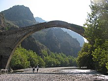
- 1 Bridge over the Aoos River (near the Gefyri hotel). With a single arch, it is a stone bridge completed in 1870 on the site of another wooden bridge from 1823 which was destroyed by a flood of the river. There was a bell that rang when the wind got strong making the passage dangerous. What we see today is not the original and dates back to 1975.
- 2 Gefira Monument (near the bridge). Here, among the remains of an ancient settlement, you can still see a marble monument.
- 3 Moni Panagias Stomiou (Μονη Παναγιας Στομιου) (on the E90). Ancient Greek Orthodox monastery dating back to 1400. It was completely destroyed by the Germans in 1943 with the exception of the church, which can now be visited.
- 4 Church of the Red Virgin (Κόκκινη Παναγιά) (The property is 1.7 miles from Konitsa). Chapel located on a pleasant hill, dating back to the thirteenth century. Many frescoes have been lost over time, but the few beautiful ones that remain date back to the 14th century. It was probably the church of a Christian village, which no longer exists.
Events and parties
What to do
Shopping
How to have fun
Where to eat
Average prices
- 1 Maneutiri (Μaneythpi), Epar.Od. Konitsas - Aetopetras (at the Konitsa exit, in the direction of the city of Aetopetras), ☎ 30 2655 022125.
 10:00-23:00.
Where stay
Average prices
- 1 Artemis Apartments Ξενοδοχείο (south of Konitsa, near the Ethniko Pindou Park), ☎ 30 26550 24774, 30 6977668390 (mobile phone), fax: 30 26550 24808.
 40 € per night (single room).
 - 2 Kougias GuestHouse (in the center), ☎ 30 2655 023830.
High prices
- Konitsa Mountain Hotel, ☎ 30 26550 29390, fax: 30 26550 29391.
- 3 Bourazani Wild Life Resort, ☎ 30 26550 61283, 30 26550 61320, fax: 30 26550 61321. Cat A hotel, open all year round.