
Kungsleden (German: the royal road) is a hiking trail in Swedish part of Lapland. It was set up by the Swedish Trekking Association Svenska Turistföreningen started around 1890. In 1926 the section Abisko – Kvikkjokk completed. Today this royal road extends over 425 km from Abisko to Hemavan and is part of the European long-distance footpath E1.
In addition, one speaks of one in the hiking world southern royal route, another hiking trail in Sweden about 350 km from Storlien to Hallswhich is not mentioned by name in the context of the STF. The two paths are not connected either, but are about 450 km apart.
Due to the common terminology, the two hiking trails are also intended here as more northerly and more southerlyKungsleden be treated.
background
The Swedish Tourist Association STF (Svenska Turistsföreningen) was founded in 1885 by a group of outdoor enthusiasts. The aim of the association was to promote tourism and make the country (Sweden) more accessible for everyone. First the mountains (Fjäll) but finally the entire country. In 1887 the first hiking trails began.
With the planning of a railway line (Erzbergbahn) between Kiruna (Sweden) and Narvik (Norway) towards the end of the 19th century, the STF recognized the opportunity to make the Lappish fells more accessible to visitors. For this purpose, a hiking route was initially planned from Abisko am Torneträsk to Kebnekaise and further after Nikkaluokta. Already about a continuation of the route up Kvikkjokk Thoughts had been given, and in the 1920s the path was gradually equipped with simple huts. The line from Abisko to Kvikkjokk was completed in 1926.
In 1928 the STF officially spoke of the Kungsleden for the first time. In the thirties the big mountain stations like Abisko, Kebnekaise, Kvikkjokk and Grövelsjön. After the original two-room huts along the Kungsleden, which became too small due to the increasing number of visitors, the larger ones were built Stugor The Kungsleden in Ammarnäs ended in 1950 and was extended to Hemavan in 1975.
preparation
There is hardly any cell phone reception and there are no telephone options on the route (exception: Saltoluokta).
overnight stay
On the northern part there are huts where you can stay for a fee (with DJH ID 20 euros, otherwise 30 euros). The huts have an equipped kitchen, but no electricity connection. You can also go camping; near the huts, however, for a fee (with the right to use the kitchen and lounge), otherwise within the framework of the public rights. At the end of the season - around mid-September - the huts close, i.e. the duty of the hut keeper (Stugvards) ends. However, at least one hut or part of a hut is always open for emergencies.
season
The connection to public transport and the huts and boat traffic will cease after the second weekend in September. Things get going again in early summer, with small mosquitos being a nuisance between June and August. The beginning of September is a nice travel time, as the mosquitoes are usually driven away by the lower temperatures. The weather then becomes more unstable.
Catering
Food can be bought in some huts every two day's stages; the range of shops in the mountain huts varies depending on the size of the hut. The assortments in the huts are measured using the names LARGE, MEDIUM and SMALL. The SMALL category denotes a limited range of goods, but sufficient for a full meal. The offer consists of canned meat, soup, freeze-dried meat, crispbread, biscuits, tube cheese, pasta, mashed potatoes, Nescafé, tea, cocoa drink, oat flakes and sweets (STF*; Status: 09/2015).
Otherwise there are no shopping possibilities during the whole northern part. Exception: STF station Saltoluokta - in addition to a well-equipped shop that also sells functional clothing, there is also the option of a rich breakfast or dinner in the rustic, cozy dining room (Matsal). Is of course not cheap, but still within limits.
getting there
For the northern part, a low-cost airline to Stockholm and then on with Swedish domestic flights is recommended flynordic to Kiruna. From there by bus or train to Abisko. Alternatively, you can also use the directly from Stockholm night Train take to Abisko.
We recommend the departure point for the return journey Lulea.
Northern Kungsleden
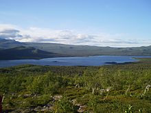
Kungsleden - the royal road - between Abisko and Hemavan is one of the most famous and perhaps the best hiking trails in the world. The trail is approximately 425 kilometers long and has been visited by hikers from around the world since it was first created in the 1920s. Kungsleden leads through a varied landscape in the mountains of Lapland. The path alternates between alpine terrain, dense birch forest and raised bogs, leads past idyllic lakes and steep peaks.
Kungsleden leads through four national parks in Laponia World Heritage Site: Abisko, Stora Sjöfallet, Sarek and Pieljekaise. The path is well marked. Especially boggy passages are protected by plank paths and there are bridges where it would otherwise be difficult to cross rivers, and reindeer can be encountered everywhere. Special consideration must be given to these. Therefore: Always keep your distance so as not to scare off the semi-wild animals.
The STF maintains no fewer than 16 mountain huts along the (northern) Kungsleden at intervals of between 10 and 20 kilometers. Between Kvikkjokk and Ammarnäs there are no STF cabins, but there are limited numbers of other accommodations.
The most common starting points for the Royal Route are Abisko, Vakkotavare, Saltoluokta, Kvikkjokk, Ammarnäs and Hemavan. who in Nikkaluokta starts and will only reach Kungsleden after 2 days of hiking.
The area is characterized by the Sami reindeer herding. The animals run around freely and are very shy. Please be considerate, keep your distance and do not scare the animals.

The route has no extreme incline and is well signposted. It is suitable for beginners. Sensitive areas in bog areas are covered with planks. The interesting thing is the wide fell landscape, less the partly existing forests. In the route section Saltoluokta - Kvikkjokk the Kungsleden leads over the lakes Sitojaure and Laitaure. The STF* (Svenska Turistföreningen - Swedish hiking club; status: 09/2015) puts rowing boats ready at such places, which can be used free of charge. Alternatively, one can resort to the chargeable luxury of motorboat transfers, which are carried out by local Sami.
The STF describes 5 stages in north-south direction:
- Abisko - Nikkaluokta
- Nikkaluokta - Vakkotavare
- Saltoluokta - Kvikkjokk
- Kvikkjokk - Ammarnäs
- Ammarnäs - Hemavan
FIRST stage: Abisko - Nikkaluokta
- Tour length: 108 km - Time required: approx. 6-7 days - Map: BD 6
This is the most traveled section, also because it is well suited for a 1-week tour. You start at the STF Abisko mountain station and find yourself in a thick birch forest in the Abisko National Park.
The area has a few peaks. Above the tree line the landscape shows plateaus, lakes, rivers and high snow-capped mountains and moorlands. You walk through a great landscape with the highest point in Tjäktja. The marked path leads mainly over rock, only during the first and last day through birch forest. Along the route there are 5 hut stations on the Königsweg where you can spend the night. After Singi station, leave the Königsweg in an easterly direction past Sweden's highest mountain, the Kebnekaise, to Nikkaluokta. Take the opportunity to climb to the Kebnekaise mountain station.
Extensive reindeer herding is prevalent in this area. Please treat the semi-wild reindeer with respect - and at a distance.
| Route section | Distance km | Hours | of level .... on level | Remarks |
|---|---|---|---|---|
| STF Abisko - STF Abiskojaure | 15 | 4-5 | 380 - 490 m | mainly Birch forest, pleasant path; along the way the Abiskojakka - worth seeing the canyon; little by little the forest thins out; after the rest area, it goes slightly uphill to the Abiskojaure station on the lake of the same name; Bridge over the Kamajakka to the hut |
| STF Abiskojaure - STF Alesjaure | 21 | 6-8 | 490 - 780 m | Initially through birch forest, soon up into the mountains; on the east side past a chain of lakes; Above the tree line, the path leads over grass and stones, later another chain of lakes - at the last, the Alesjaure, is the hut; Possibility to cross the lake by boat. |
| STF Alesjaure - STF Tjäktja | 13 | 4-5 | 780 - 1000 m | Mountain hiking as it couldn't be nicer; easy way; Heather everywhere surrounded by high mountains and glaciers; Bridge over the meandering river Alesätno; there are lots of birds to watch; Path goes slightly uphill over meadows; only shortly before the pass does it get steep and rocky; the hut is on the other side of the river - accessible via a bridge. |
| STF Tjäktja - STF Sälka | 12 | 3-5 | 1000 - 835 m | open spaces and wonderful panoramas await you; on the other side of the pass it goes down into Tjäktjavagge; steep and rocky descent; only at the end of the valley does the Sälka station come into view; |
| STF Sälka - STF Singi | 12 | 3-4 | 835 - 720 m | one of the most beautiful routes in the Swedish mountains; impressive peaks, steep slopes and glaciers and moors "along the way"; breathtaking views of Drakryggen and the north side of Kebnekaise; near Singi is a Sami summer camp Kårtjevuolle; |
| STF Singi - Kebnekaise | 15 | 4-6 | 720 - 650 m | Here you leave the royal road. Between the Singi hut and Kebnekaise it goes through the sometimes dramatically narrow Laddjuvagge. Between Singi and Kebnekaise there are some of the country's classic climbing routes, such as the silhouette of the Toulpagorni. The first few kilometers are only moderately uphill before you reach Lassajaure. Very nice views in both directions. The hike continues in an easterly direction through the passage between Singitjåkkas and Skárttoaivis with rough steep walls. Then the Laddjuvagge widens. The last kilometers to the Kebnekaise are partly stony terrain. If the weather permits, you shouldn't overrun the Kebnekaise mountain station. There are also guided tours up. |
| Kebnekaise - Nikkaluokta | 19 | 5-7 | 650 - 470 m | A few kilometers east of Kebnekaise it goes over the mountain river Tarfalajåkka, which comes from the glacier in Tarfaladalen. The path continues on a gentle slope; often stony and with plank paths. The birch forest is gradually becoming thicker. You can shorten the route by around 6 km if you can be picked up by boat. The boat runs several times a day according to a timetable. The last part leads over a narrow, stony footpath and ends in Nikkaluokta - restaurant and small shop available. |
SECOND stage: Nikkaluokta - Vakkotavare
- Tour length: 72 km - time required: approx. 5 days - map: BD6, BD8
The path runs between Nikkaluokta and STF Vakkotavare and after the first step you reach the Kebnekaise mountain station. Most of the path consists of birch forest and it is possible to shorten the hike by 6 km by boat transfer.
The journey continues west towards the passage between Singitjåkkas and Skárttoaivis with rough steep walls. The valley opens just before you reach the STF Singi hut. The view from here is impressive. To Kaitumstugorna (Kaitumhütte), the Kungsled offers an easy hiking route in a large landscape. The babbling of the river accompanies you along the way Tjäktjajåkka.
The next day, the STF huts are in hilly terrain Teusajaure. This short stage offers both birch forest and permanent ups and downs in the terrain. The last stage of the last day of hiking begins when you have crossed Lake Teusajaure. Motorboat transfers are available in the mornings and evenings during the season. But you can also use the rowing boats provided by the STF. There are a total of three row boats, however note that there must always be at least one boat on each bank. This means that you have to cross the lake 3 times if you start on the bank where there is only 1 boat (i.e. 1x there in the existing boat, 1x back with a boat in tow; 1x back in a boat).
The begins on the opposite bank Stora Sjöfallet National Park. When the view is good you can see the plateau in the distance Sarek-Mountains see. The hike with a steep sloping end to the Vakkotavare-Hütte, next to the bus stop for the bus going east Kebnats is. The bus and boat timetables (from Kebnats station to Saltoluokta) are coordinated. The bus continues to follow Gällivare: There are other bus routes, railways and domestic airports there.
| Route section | Distance km | Hours | of level .... on level | Remarks |
|---|---|---|---|---|
| Nikkaluokta - Kebnekaise | 19 | 5-7 | 470 - 650 m | see last section of the first stage! |
| Kebnekaise - STF Singi | 15 | 4-6 | 650 - 720 m | At the Singi hut you will meet the Königsweg. See the penultimate section of the first stage! |
| STF Singi - STF Kaitumjaure | 13 | 4-6 | 720 - 620 m | Easy walk from Singi station along the river Tjäktjajåkka all the way down to Lake Kaitumjaure. Here is traditional reindeer grazing area. After initially hilly terrain, it changes to flat marshland. Lots of good break spots with good water. Only 3 km before the station Kaitumjaure the way becomes a little more difficult. Excursion to Mount Sanjartjåkka possible with a great view. |
| STF Kaitumjaure - STF Teusajaure | 10 | 3-5 | 620 - 500 m | Nice hike mainly over rock. When the weather is clear you look at them all the time SarekMountains on the horizon. About 1.5-2 km after the start bridge over the Kaitumjåkka. On the other bank, the terrain becomes stony. About 5 km south of Kaitumjaure is a hut that was renovated in early 1900 and provides shelter as an emergency shelter. Another 1 km further you reach the highest point of this section with a height of 780 m. Then it goes up to about 1 km before the Teusajaurestugorna over a plateau. The last part down to Lake Teusajaure is crisp and steep. |
| STF Teusajaure - STF Vakkotavare | 15 | 5-7 | 500 - 415 m | The hut is right on the lake. It starts with the lake crossing (approx. 1.5 km) using the STF rowing boats. The Stugvard may offer a motorboat transfer. The national park border runs right through the middle of the lake. On the other bank one stands in Stora Sjöfallet National Park. Then it runs parallel to the Cap jacket Over about 5 km from 500 to 900 meters in altitude - first through birch forest, then over a stony path. Gradual decline from about the point between Lake 874 and mountain RappattjarroFrom the last 2 km it goes steeper downhill - especially crisp on the last kilometer (total down from 700 to 415 meters in altitude) Vakkotavare-Hut is right on the road Ritsem – Gällivare. There is regular bus service here (twice a day). To Ritsem (direction west), who drives over the reservoir Akkajaure translate and the Padjelantaleden want to hike or the Sarek Wants to cross the national park. If you want to continue the Königsweg, take the bus about 40 km to the east to the stop Kebnats. Here the ferry crosses over to the 110-year-old STF station Saltoluokta. |
THIRD stage: Saltoluokta - Kvikkjokk
- Tour length: 73 km - Time required: approx. 4 days - Map: BD10
On the slightly over 7 miles long route (1 Swedish mile = 10 km) you move in an exciting borderland between the high Sarek Mountains and woodlands to the east. You run through swamp, mountain forest, cross the lakes Sitojaure and Laitaure by boat and have the opportunity to turn into the Sarek at several points.
At the station Files there is the possibility of a trip up the mountain Skierfe and from its 700 m high steep face a fantastic view of the Rapa Delta to enjoy what the Rapaätno - the Rapa River - has created.
The last section up Kvikkjokk leads past other lakes and through old coniferous forest. In the village of Kvikkjokk there is again a connection to the road (and bus connections).
| Route section | Distance km | Hours | of level .... on level | Remarks |
|---|---|---|---|---|
| STF Saltoluokta - STF Sitojaure | 19 | 6 - 8 | 390 - 630 m | Saltoluokta lies in an old pine forest. You walk about 4 km and 400 meters in altitude through this coniferous forest and later through birch forest until you have reached the tree line. From here you have a fantastic view back over the lake Langas, the mountains in the north and the Lulep Kierkau on the left. Once above the tree line, the path is easy and, for the most part, even pleasant to walk. It leads through the vastness Autsutjvagge and gradually descends down to the lake Sitojaurewhere the hut of the same name is located (Sitojaurestugorna). |
| STF Sitojaure - STF Aktse | 10 | 3 - 5 | 630 - 540 m | The elongated one Sitojaure has two appendages at its southern end, each separated by isthmus: Den Kaskajaure and the Kabtajaure. These two (partial) lakes have to be rowed over: The easy rowing route is a good 4 km long. Motorboat transfers possible through local Sami. Vindskydd Svine on the other bank. The next 4 km lead through, or better: over swamp. Long stretches of plank paths, some of which lead 1 m above the ground. No handrail and often stubborn willows that have let their branches grow over the plank path. So be careful! After reaching the tree line, the climb is relatively steep, past the mountain Martevaratj on a plateau. From here it is about 6 km to Files, 4 of them on the plateau. There is hardly any drinking water up here. If you want to camp here, you have to search for water for a long time or have a lot in your luggage. Where the plateau ends and the steep descent (very steep; step-like) begins, a path branches off to the west. This leads to the mountain Skierfe, where you have the best view of the Rapa Delta Has. Recommended: camp at the crossroads and organize a day tour to the Skierfe without luggage. One way around 6-7 km; not difficult, rocky in the last part. No climbing. IT IS WORTH IT! The last part down to Aktse then leads through old forest, but steeply down. |
| STF Aktse - STF Pårte | 22 | 8 - 10 | 540 - 500 m | Crossing the lake right at the beginning Laitaure. A good 1 km to the landing stage. STF rowing boats are ready; Alternatively, the Sami motorboat transfer can be rented. Rowing distance: approx. 4 km. On the other bank approx. 5 km through forest. Then a short, relatively steep ascent to the windbreak (Vindskydd) Rittak. For a few kilometers the Königsweg leads through the south-easternmost tip of the SAREK National Park. Rittak is halfway and is intended as an emergency shelter. Then the path leads over the pass between the mountains Faunaåive and Huornatj. After the pass it goes permanently downhill; after reaching the tree line until Pårte through beautiful coniferous forest. |
| STF Pårte - Kvikkjokk | 17 | 6 - 8 | 500 - 320 m | This section only leads through forest. First it goes along the lake Sjabtjakjaurewhere the Pårte hut is located. Before the next lake (Stuor-Tata) you take the bridge over the Tjåltajåkka. Now the road is getting worse and increasingly rocky. South of the Stuor Tata it gets more and more swampy. If you want to camp, you should do it in the vicinity of the lake during the summer season (because of the mosquitos). From the bridge and from the southern tip of the Unna TataLakes, centuries-old paths lead north to the seed settlement Pårek through a lake district. This area is again within the Sarek National Park. The last kilometers up Kvikkjokk are simple. By now, hordes of hikers should have stepped at least 20 m wide on the path. Large STF station in Kvikkjokk; small supermarket on site; Road and bus. |
FOURTH stage: Kvikkjokk - Ammarnäs
- Tour length: 180 km - time required: approx. 10-12 days - tickets: BD14, BD16
The section between Kvikkjokk and Ammarnäs is the least frequented on the Kungsled. This section requires you to camp for a few nights. But the views along the route are impressive - especially in Pieljekaise National park. Early autumn (August and September) is the best time to hike here. Then the landscape glows in yellow-red autumn colors and the mosquitoes disappear.
The path is demanding because it goes up and down. The difference in altitude between the river valleys and plateaus is a few hundred meters. Several smaller communities, huts and holiday homes give the area its own character, in contrast to other parts of the Kungsled. Boats are no longer transported on the route that you organize on site.
For ornithologists this is Svaipa Bird sanctuary particularly interesting. At the end towards Ammarnas you come across an elongated ridge that offers a fantastic view of the river valley.
| Route section | Distance km | Hours | of level .... on level | Remarks |
|---|---|---|---|---|
| STF Kvikkjokk - Tsielekjåkk | 15 | xxx | xxx - xxx m | Tsielekjåkk = emergency hut |
| Tsielekjåkk - Vuonatjviken | 46 | xxx | xxx - xxx m | |
| Vuonatjviken - Jäckvik | 20 | xxx | xxx - xxx m | |
| Jäckvik - Pieljekaise | 8 | xxx | xxx - xxx m | |
| Pieljekaise - Adolfström | 8 | xxx | xxx - xxx m | |
| Adolfström - Bäverholmen | 8 | xxx | xxx - xxx m | |
| Bäverholmen - Sjnjultje | 25 | xxx | xxx - xxx m | |
| Sjnjultje - Rävfall | 25 | xxx | xxx - xxx m | |
| Rävfall - Ammarnäs | 25 | xxx | xxx - xxx m |
FIFTH stage: Ammarnäs - Hemavan
- Tour length: 78 km - Time required: approx. 5-6 days - Maps: AC2 1: 100,000; Ammarnäs & Hemavan Calazo 1: 100,000
This is the southernmost stage of the northern Kungsleden. The path leads through Vindelfjällen, which is one of the largest protected nature reserves in Europe. Open heathland, lush birch forests, wetlands and primeval forests of lichen-covered spruce await you here. The varied environment creates the conditions for the settlement of a large variety of plants and animals.
The six sections of this stage have their own character. Kilometers of views of valleys with steep slopes and surrounded by high peaks. At the Syterpasset for example there are towering peaks up to 1700 meters on both sides.
STF has built five mountain huts along this part of the Kungsleden. Again, please be considerate of the reindeer herds.
| Route section | Distance km | Hours | of level .... on level | Remarks |
|---|---|---|---|---|
| Ammarnäs - STF Aigert | 8 | xxx | xxx - xxx m | |
| STF Aigert - STF Serve | 19 | xxx | xxx- xxx m | |
| STF Serve - STF Tärnasjö | 14 | xxx | xxx - xxx m | |
| STF Tärnasjö - STF Syter | 14 | xxx | xxx - xxx m | |
| STF Syter - STF Viterskalet | 12 | xxx | xxx - xxx m | |
| STF Viterskalet - Hemavan | 11 | xxx | xxx - xxx m |
South Kungsleden
The southern section of the Kungsleden hiking classic in Sweden runs from Storlien to Sälen along the Norwegian border. You walk 360 km through the Swedish provinces of Jämtlands Län and Dalarnas Län, passing through alpine fells, birch and pine forests, marshland and the unique moraine landscape of the roe area. More varied and lonely than the northern Kungsleden in Lapland, the lesser known southern Kungsleden doesn’t need to hide behind its big brother
Required hiking maps:
- Storlien-Helags-Fältjägarstugan: Fjällkartan Z6 Storlien-Ljungdalen
- Helags-Rogenstugan: Fjällkartan Z8 Helags-Funäsdalen-Rogen
- Rogenstugan-Grövelsjön-Drevfjället: Fjällkartan W1 Rogen-Grövelsjön-Lofsdalen
- Drevfjället-Sälen: Fulufjället-Sälenfjällen
SIXTH stage: Storlien - Fjällnäs
- 91 km hut tour possible (with a detour), otherwise combined.
| Route section | Distance km | Hours | of level .... on level | Remarks |
|---|---|---|---|---|
| Storlien / Storvallen - Blåhammeren | 10 | xxx | xxx - xxx m | |
| Blåhammaren - Sylarna | 19 | xxx | xxx- xxx m | |
| Sylarna - Helags | 19 | xxx | xxx - xxx m | |
| Helags - Fältjägaren | 12 | xxx | xxx - xxx m | |
| Fältjägaren - Fjällnäs | 31 | xxx | xxx - xxx m |
SEVENTH stage: Fjällnäs - Grövelsjön
- 80 km hut or tent tour
| Route section | Distance km | Hours | of level .... on level | Remarks |
|---|---|---|---|---|
| Fjällnäs - Skedbro | 25 | xxx | xxx - xxx m | |
| Skedbro - roe | 17 | xxx | xxx- xxx m | |
| Roe - Storrödtjärn | 17 | xxx | xxx - xxx m | |
| Storrödtjärn - Hävlingen | 9 | xxx | xxx - xxx m | |
| Hävlingen - Grövelsjön | 13 | xxx | xxx - xxx m |
EIGHTH stage: Grövelsjön - Sälen
- 178 km tent tour, but many simple huts, some with overnight accommodation
This last stage leads over the Fulufjäll past the southernmost Swedish fells.
security
trips
literature
... only until then! Trekking in the Sarek, of Klaus Heyne, 2014; ISBN 978-3732234325 (Travel description with Kungsleden section Saltoluokta-Aktse)