The Lake District National Park located in England. It protects the mountain world of the almost 1000 m high Cumbrian Mountains, whose alpine terrain, together with the numerous lakes in the region, forms an attractive landscape and attracts around 14 million visitors annually. In 2017 this exceptionally beautiful landscape was added to the list of World heritage set.
background

history
The first settlers in the Lake District were hunters and gatherers in the Neolithic Age. Since they lived as nomads, not many traces of their existence have survived. An exception is e.g. the Stone Ax Factory on the steep slopes of Pike o'Stickle in Langdale. Here, around 4,000 years ago, the volcanic tuff was excavated and made into ax heads. Significantly more striking witnesses of the past are the Swinside Stone Circle, Castlerigg Stone Circle or Long Meg and her Daughters. During the occupation of Britain by the Romans, Hadrian's Wall was built north of the Lake District and within the national park the camps Hardknott (on the pass of the same name) and Galava (Ambleside). In today's Ravenglass there was an important port, the ruins of a bathhouse have been preserved. Today only names remind of the time of the Vikings. The terms “fell” (mountain slopes with open pastures), “tarn” (small mountain lakes) or “beck” (brook) are of Nordic origin. From the 16th to the 19th centuries, the Lake District mines mined copper, lead, barite, graphite and shale. Towards the end of the 17th century tourism began to develop, which increased further in the 1840s with the construction of the railway lines. The first travel guide, William Wordsworth's Guide to the Lakes, was published in 1810. Today the Lake District is one of the most popular holiday destinations in England. The Lake District National Park was established in 1951. With an area of 2,292 km² (885 mi²) it is the largest national park in England.
landscape
The Lake District impresses with its scenic diversity. It offers easily accessible areas for everyone, while large areas in the center of the national park can only be reached on foot. The mountains of "Lakeland" or simply "the Lakes", as the Lake District is also called, include the highest mountains in England: Scafell Pike (978 m / 3,210 ft), Scafell (964 m / 3,210 ft), Helvellyn (950 m / 3,118 ft) and Skiddaw (931 m / 3,053 ft). England's tallest mountain outside the Lake District is Cross fur (893 m / 2,930 ft).
The current appearance of the landscape was created around 10,000 years ago at the end of the Ice Age. The glaciers had washed valleys out of the mountains and moraines formed. When the glaciers melted, the water pooled in the valleys and the lakes formed. The U-shape of a glacier valley is easy to see at the Honister Pass. In the middle of the Lake District are jagged mountains made of hard, volcanic rock (including the Scafell Pike). From this center point, the lakes are arranged in a radial pattern; in the higher regions there are numerous cirques, in which there are often tarns. High moors spread out under the rocky regions. The mountains and hills in the north of the park are made of soft slate, they are rounded.

Flora and fauna
flora
At Windermere and Coniston Water there are still remnants of the original forest. Sessile oaks, birches, Scots pine and holly grow here. There are also some areas that have been reforested with conifers. Areas overgrown with heather and grassy areas can be found above the tree line. The vegetation differs according to the amount of precipitation. The grassy areas are used as sheep pastures. Alpine plants, e.g. Alpine women's mantle and dwarf birch, thrive on the scree fields. The vegetation along many streams consists of birch, ash, mountain ash and butterbur. Since it is very humid in the Lake District, various ferns and mosses thrive. There are also colonies of sundew, a carnivorous plant.
fauna

The Lake District is one of the last areas in Great Britain where the red squirrel is still native. The population was displaced nationwide by the gray squirrel. It can still be found in the forests on Ullswater and Tarn Hows, while semi-wild fur ponies, deer and sheep roam the mountain slopes and moors. The Herdwick sheep are a native, robust breed.
In some lakes there are rare and threatened species of fish (vendace, schelly and arctic char). A relic from the Ice Age has been preserved in Ennerdale: a freshwater shrimp. More common residents are: trout, pike, perch and salmon
Birds that live here include buzzards, peregrine falcons, ravens, cormorants, herons, dippers and ducks. Ospreys and red kites were able to be reintroduced. Seasonal visitors are: ring owls and redstart
climate

Because of its location near the sea and mountains, the Lake District is one of the wettest regions in England. But there are big differences: Seathwaite (Borrowdale) is the front runner with over 5000 mm of precipitation per year, in Keswick at the end of Barrowdale it is 1470 mm and in Eden (near Penrith) 790 mm During the year there are only slight differences in temperature. Snow can fall between November and April, but it does not stay in the valleys for long. Strong winds and fog can occur throughout the year.
places
- Ambleside - Located at the northern end of the Windemere (2600 inhabitants). Quite central location for a hiking vacation in the Cumbrian Mountains.
- Bowness-on-Windermere - Popular tourist center on Windemere, the largest lake in the region (3800 inhabitants).
- Coniston - is located between Coniston Water and the Old Man of Coniston Mountain. Popular starting point for hikers.
- Grange - The small village is in Barrowdale at the foot of the Grange Fell and Castle Crack mountains. The old pack horse bridge, which leads over the river Derwent with two arches, is worth seeing.
- Grasmere - small village in the heart of the Lake District. Those who like to be out and about in the mountains can z. B. set up his base camp here.
- Hawkshead - the pretty little town is between Coniston Water and Windermere
- Keswick - Centrally located tourist center in the northern part of the Lake District
- Ravenglass - the only coastal town in the Lake District. This is where the Ravenglass & Eskdale Railway begins / ends.
getting there
By plane
The nearest international airports are all a short distance away Newcastle Airport![]()
![]()
![]() (IATA: NCL), the Liverpool John Lennon Airport
(IATA: NCL), the Liverpool John Lennon Airport![]()
![]()
![]() (IATA: LPL), the Glasgow Airport
(IATA: LPL), the Glasgow Airport![]()
![]()
![]() (IATA: GLA), Leeds Bradford International Airport
(IATA: GLA), Leeds Bradford International Airport![]()
![]()
![]() (IATA: LBA) and, with the widest selection, Manchester Airport
(IATA: LBA) and, with the widest selection, Manchester Airport![]()
![]()
![]()
![]() (IATA: MAN).
(IATA: MAN).


By train
From Windermere there is a connection to Kendal (from here there is a direct connection to Manchester Oxford Road and with a change at Oxenholme to London Euston and Birmingham New Street).
By bus
Long-distance buses
- National Express. Route 571 connects London (once a day from London Victoria, via Birmingham and Blackpool, as of 2014) with the Lake District. The buses stop within the national park in the towns of Windermere, Ambleside, Grasmere and Keswick.
In the street
All distances to Kendal:
- Liverpool: via the M 62 and M6 (approx. 125 km) via Lancaster.
- Leeds: approx. 105 km. Via Ilkley and Skipton, from Skipton on the A65.
- Manchester: approx. 130 km. Take the M61 to Preston, then the M6 north to Junction 36, then the A591.
- Kingston upon Hull: approx. 220 km. Via Leeds, Ilkley, Skipton and then follow the A65.
- Kendal: from here on the A 591 to Windermere (the road ends in Keswick).
- Carlisle: the city is north of the Lake District. Via the M 6 and Penrith (approx. 38 km) or via the B 5299 to the northernmost tip of the national park. From Newcastle upon Tyne to Carlisle it is approx. 100 km, always follow the A 69.
- Penrith: can be reached via the M 62 and M 6 from Liverpool (approx. 170 km). From here via the A 66 to Keswick or the A 592 to Ullswater.
By boat
- Newcastle upon Tyne, distance to Carlisle approx. 100 km, on the A 96. From Newcastle there are ferry connections to Amsterdam with DFDS.
- Kingston upon Hull, distance to Kendal approx. 220 km, ferry connections with P&O Ferries to Rotterdam and Zeebrugge.
- Dover, distance to Kendal approx. 555 km, several connections daily to Calais (DFDS, P&O and My Ferry Link) and Dunkirk (DFDS).
Fees / permits
The national park is freely accessible. Many of the official parking spaces are chargeable.
mobility

By car
The roads within the national park are normal country roads, some of which are very steep and narrow, e.g. B. Hardknott and Wrynose Pass. These single-lane passes are unsuitable for motorhomes and caravans. At the starting points for hikes you can often park on the roadside, in the places the parking spaces are chargeable
Bus and ferry
On Lake Windermere, the Lake District's only car ferry operates between Ferry Nab, Bowness and Ferry House, Far Sawrey. The timetable for the ferry and for buses is here to find.
On foot
- For information on the use of hiking trails, see England (Mobility)
- The hiking trails are well signposted, but you should still have a hiking map with you.
With the wheel
The National Cycle Network (NCN) routes run through the Lake District
- The NCN 6that of Kendal on the southern border of the national park once lengthways through the Lake District to Thelkeld bei Keswick leads.
- The Coast-to-Coast Route (NCN 71) runs from west to east through the northern Lake District. It starts in Workington on the west coast and runs off Cockermouth in the national park through largely unpopulated area up to the eastern national park border Penrith, from where it continues towards the east coast.
Tourist Attractions

Lakes
There are a total of 16 lakes and countless tarns (mountain lakes) in the Lake District. Some of the lakes are smaller than the Tarns. But there are also many very small tarns that have no name.
Belong to the lakes
- Bassenthwaite Lake. The third largest lake in the Lake District and the only one in whose name the word "lake" appears. It's near Keswick. The 931 m high Skiddaw rises above the east bank.
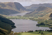
- Buttermere. Beautifully situated at the end of a valley, which is framed by towering mountains (High Stile (807 m), Robinson (737 m), Fleetwith Pike (648 m), Haystacks (597 m), Grasmoor (852 m)). Buttermere is only separated from Crummock Water by a mile of flat land.
- Coniston Water. The neat, historic "Steam Yacht Gondola" of the National Trust operates on the lake. Built in 1859, she is the oldest "steam yacht" in Northern England (Info on the website of the National Trust).
- Crummock Water. Is separated from Buttermere by a 1 km wide flat strip of land. South of the lake lies the Scale Foce in a steep, wooded gorge, which consists of several waterfalls (total height approx. 52 m).
- Derwent Water. Located at the end of Borrowdale and south of Keswick. It is surrounded by mountains that are forested near the shore. There are 4 small islands in the lake. You can go on the lake with Excursion boats drive.
- Elterwater. The small lake is located near the town of the same name in Great Langdale.
- Ennerdale Water. The most westerly and lonely lake, there are no roads on its banks.
- Esthwaite Water. One of the small, lesser known lakes in the national park. Nearby is the pretty village of Hakshead and the Grizedale Forest.
- Grasmere. Smaller lake (about 1500 x 400 m) near the village of Grasmere in the center of the Lake District.
- Haweswater Reservoir. The easternmost lake and one of the largest (4 mi / 6.5 km long and 0.5 mi / 1.5 km wide) in the national park. There are no towns on its banks.

- Loweswater, in the wooded Vale of Lorton. The lake is one of the smaller ones and can be hiked around. Squirrels live in the woods. Rowing boats can be hired from Watergate Farm des.
- Rydal Water. The small lake is 1.1 km long and 370 m wide. It is picturesquely situated between the Loughrigg and Nab Scar. A beautiful loop around the lake leads to Dove Cottage and Rydal Mount (both houses where the poet William Wordsworth lived) and to Rydal Cove. There are steps from the lake to Wordsworth's Seat lookout.
- Thirlmere. The lake was created by damming two smaller lakes. To the east of the lake is the Helvellyn (950 m), the third highest mountain in England.
- Ullswater. 12 km long and up to 1 km wide body of water in the northeastern area of the region with passenger shipping: Ullswater Steamers.
- Wast water, located in Wasdale. It is the deepest lake in England, the water level is 60 m above sea level, the deepest point 79 m below sea level. To the southeast, the lake is bounded by the steep slopes of the Whin Rigg and Illgill Head mountains called Wastwater Screes.
- Windermere. At 17 km long and between 0.5 and 1.5 km wide, it is the largest lake region. In the area of the water lies Bowness, which together with Windermere is one of the tourist centers of the region (Bowness-on-Windermere). Passenger shipping: Windemere Lake Cruises.
More lakes
- Angle camouflage. Located in the Angletarn Pikes at 480 m above Patterdale. There are two small islands in the lake, low cliffs in the west and grassy slopes in the east - the ideal place for a picnic.
- Hayeswater. One of the smaller lakes (approx. 1 km long and 200 m wide). The natural lake is dammed by a small dam.
- Innominate tarn. Lies picturesquely south of the summit of Mount Haystacks at 520 m altitude. Nice view over the Lake District.
- Tarn Howes. One of the favorite tourist destinations. The Tarn was created by damming, originally there were three small lakes here. Today the lake is owned by the National Trust.
Valleys

- Borrowdale. The valley is in the center of the Lake District. It is traversed by the River Derwent, which flows into Derwentwater. The B 5289 runs through the whole valley and leads over the Honister Pass to Buttermere. The Bowder Stone, the bridge at Grange and the Lodore Falls are worth seeing. From the lake a road leads up the mountain to Watendlath. There are two viewpoints here: at the Ashness Bridge and the Surprise View.
- Eskdale. Located in the west of the national park, from the center of the park you can get to Eskdale via Wynrose and Hardknott Pass. The Ravenglass & Eskdale Railway runs through the valley. Great view from the Hardknott Roman Fort.
- Little Langdale. A trade route once ran through the valley, the Slater Bridge is well worth a visit. The Lingmoor Fells separate Little from Great Langdale. Little Langdale leads to Wynrose and Hardknott Passes. A footpath leads over the Slater Bridge to Cathedral Cave (Quarry).
- Great Langdale. In the north, the valley is bounded by the Langdale Pikes, these mountains include the Harrison Stickle and the Pike of Stickle. The Dungeon Ghyll waterfall is worth seeing.
- Wasdale. Is the loneliest and wildest valley in the Lake District. At the end of the valley is the hamlet of Wasdale Head.
Museums
- 1 Windermere Steamboat Museum, Rayrigg Road, Windermere. Tel.: 44 (0)15394 45565, Fax: 44 (0)15394 88486, Email: [email protected]. Open: currently closed due to renovations (as of 2014).
- 2 Blackwell, Bowness-on-Windermere. Tel.: 44 (0)15394 46139, Fax: 44 (0)15394 88486, Email: [email protected]. Open: January 17 to December 20, Monday to Saturday from 10.30 a.m. to 5 p.m. (in winter until 4 p.m.), Sundays only in July and August from 12 p.m. to 4 p.m.Price: £ 7.25.
- Beatrix Potter Gallery, Main Street, Hawkshead. Tel.: 44 (0)15394 36355, Email: [email protected]. Open: March 1 to October 31, daily 10.30 a.m. to 5 p.m., partly closed on Fridays (as of 2014).Price: £ 5.00.
- 3 Museum of Lakeland Life, Abbot Hall, Kendal. Tel.: 44 (0)1539 722464, Fax: 44 (0)1539 722494, Email: [email protected]. Here you can see the originals of the drawings and illustrations by Beatrix Potter.Open: January 17 to December 20, Monday to Saturday 10.30 a.m. to 5 p.m. (in winter until 4 p.m.), Sundays only in July & August 12 p.m. to 4 p.m. (as of 2014).Price: £ 5.00.
Farmhouses, country estates and monasteries
- 4 Dove Cottage, Grasmere. Tel.: 44 (0)15394 35544. The whitewashed Dove Cottage was a pub before Wordsworth moved in. The poet lived here with his wife, children and sister for 14 years. You can see personal items and contemporary furniture.Open: March 1 to October 31, daily 9:30 a.m. to 5:00 p.m., November 1 to February 28, daily 9:30 a.m. to 4:30 p.m. (as of 2014).Price: £ 7.75.

- 5 Hill top, Near Sawrey, Hawkshead. Tel.: 44 (0)15394 36269, Email: [email protected]. Open: February 15 to December 24, see website for times (as of 2014).Price: £ 9.00.
- 6 Townend Farmhouse, Troutbeck. Tel.: 44 (0)15394 32628, Email: [email protected]. The farmhouse was built around 1626 and was the home of a yeoman farmer. You can see beautifully crafted furniture. There is a small garden in front of the house.Open: Wednesday to Sunday house 1 p.m. to 5 p.m. (some guided tours in the morning), garden 11 a.m. to 5 p.m. (as of 2014).Price: £ 5.25.

- 7 Brantwood, At Coniston. Tel.: 44 (0)15394 41396, Email: [email protected]. The house stands above Coniston Water, in summer you can take the steam yacht “Gondola” over from Coniston. Brantwood was the home of Victorian art critic and revolutionary John Ruskin.Open: March 17 to November 30, daily 10.30 a.m. to 5 p.m., December 1 to March 15, Wednesday to Sunday 10.30 a.m. to 4 p.m. (as of 2014).Price: £ 7.20 (house & garden).
- Dalemain House & Garden, At Penrith. Tel.: 44 (0)17684 86450, Fax: 44 (0)17684 86223, Email: [email protected]. Open: April 6th to October 30th, Sunday to Thursday House & Garden 11:15 am to 4:00 pm, 2nd November to December 17, Sunday to Thursday 11 a.m. to 3 p.m. garden only (as of 2014).Price: £ 10.50.
- Isel Hall, At Cockermouth. The current house is built around a Pele Tower (well-fortified residential tower, which is typical for Nordendland) from the 14th century.Open: From April to the beginning of October on Mondays (as of 2014).
- 8 Lowther Castle, Lowther (Penrith). Tel.: 44 (0)1931 712192, Email: [email protected]. The headquarters of the Earls of Lonsdale, the current building was built from 1806. A large, elegant building was created. After the owner's death, it was found that these proportions could no longer be financed in the 20th century and the building was abandoned. The interior was removed, leaving an empty shell. Until 2011, when the garden was made accessible, nobody took care of the palace and the garden. Restoration work began in the same year. Since 2013 you can also visit the castle ruins and a museum.Open: Daily from 10 a.m. to 5 p.m. (as of 2014).Price: £ 8.00 (garden & ruin).
- 9 Mirehouse, Keswick, Cumbria CA12 4QE. Tel.: 44 (0)17687 72287, Email: [email protected]. Mirehouse, built in 1666, is just a few hundred yards from Bassenthwaite Lake. Near the house, almost on the lakeshore, is St. Bega's Church. The house is still inhabited, so only a few rooms can be visited. A garden is attached to the Mirehouse.Open: April 1 to October 31, garden daily 10 a.m. to 5 p.m., house Wednesday, Saturday, Sunday (Friday in August) 1.30 p.m. to 4.30 p.m. (as of 2014).Price: Garden & House: £ 7.80, Garden £ 4.00.
- 10 Muncaster Castle, Ravenglass. Tel.: 44 (0)1229 717614, Fax: 44 (0)1229 717010, Email: [email protected]. Muncaster Castle was built in 1208 on ruins from Roman times. The Pennington family has owned the castle ever since. The castle is surrounded by an extensive garden, from mid-April the garden begins to bloom, then the woodland garden has a carpet of bluebells. There is also a rhododendron collection.Open: March 30th to September 3rd Garden & Owl Center daily 10.30am to 5pm, Castle daily, except Saturday 12pm to 4.30pm.Price: £ 13.00 (Castle, Garden, Owl Center & Maze).
- 11 Rydal Mount, Rydal, Ambleside. Tel.: 44 (0)15394 33002, Fax: 44 (0)15394 31738. The original Tudor period cottage has been converted into an elegant mansion. Wordsworth lived here with his family for 37 years. Portraits, personal items and many first editions of his works can be seen in the beautifully furnished rooms. A garden is attached to the house.Open: March 1 to October 31, daily 9.30 a.m. to 5 p.m., November, December & February Wednesday to Sunday 11 a.m. to 4 p.m. (as of 2014).Price: £ 7.00.
- Shap Abbey, at Shap, accessible at all times. The ruin stands in a lonely valley on the River Lowther. Shap Abbey was the last monastery in England to be founded in 1199 and the last to be disbanded in 1540 during the Reformation. After the abbey was closed, the stones were used for the construction of other buildings, only low remains of the wall have survived. The tower from the 15th century has been preserved in its entirety (without the roof).
Wrynose Pass and Hardknott Pass

It's only 15 miles from Skelwith Bridge to Eskdale Green, but it's spectacular as the single lane road runs through the Cumbrian highlands. It first runs through Little Langdale and then climbs up to Wynrose Pass. At the apex of the pass is the Three Shire Stone, it marks the point at which the borders of the old counties of Cumberland, Lancashire and Westmorland met. Then it's down to the Wrynose Bottom. Shortly after the bridge over the Duddon, the road goes uphill again, the Hardknott Pass (uphill / downhill gradient up to 30%) is reached. It lies at an altitude of 393 m. The remains of the Hardknott Roman Fort are about 200 m above the ground. A Roman road ran roughly parallel to today's road. They connected the port of Ravenglass to the Hardknott and Galava camps (near Ambleside), both of which are often closed due to ice and snow and are among the steepest roads in England.
Prehistoric sites
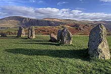
12 Castlerigg Stone Circle
Location: at Keswick
Accessibility: anytime, free entry
The Castlerigg Stone Circle is a beautifully situated megalithic site, from here there is a beautiful panoramic view over the mountains of Cumbria. The stone circle dates from around 3000 BC. And consists of 38 carefully arranged stones. Why they were built and what purpose they served remains a mystery to this day. Within the stone circle itself there is a rectangle made up of 10 more stones, known as the "cove". This arrangement is unusual among stone circles in Britain and the purpose of the "cove" remains unknown.
Swinside Stone Circle
Location: near Broughton-in-Furness
Accessibility: only visible from a public footpath
The stone circle consists of 55 stones, the highest of which is about 2.30 m. The slate stones from the surrounding mountains. There is an easily recognizable entrance. There are two Potral stones outside the circle. If you look from the center of the circle between them, your gaze falls on the place where the sun rises at the winter solstice.
Blakeley Rise Stone Circle (Kinniside Stone Circle)
Location: On the country road from Ennerdale Bridge to Calder Bridge
Accessibility: anytime, free entry
The stone circle consists of 11 stones (the largest is 1.50 high). Kinniside was reconstructed, this can be seen from the fact that the stones are embedded in cement. A visit is worthwhile for the view: on a clear day to the coast at Whitehaven, Scotland and the Isle of Man. The stone circle lies in a heather moor landscape.
Roman sites
13 Hardknott Roman Fort (Mediobogdum)
Location: at the west end of Hardknott Pass, the closest place is boat. A short walk from the street leads to the fort.
Accessibility: anytime, free entry
The Romans built the fort between 120 and 138 AD, it has since been abandoned during the campaign of Emperor Antonius. It was then used from around AD 200 to the late 4th century and served to protect the Hardknott Pass, which was part of the Roman Road and connected the fortifications of Ravenglass and Ambleside. The rectangle of the outer walls is easy to see. Remains of the walls of the barn, the commanders' house and the administration have been preserved within the protected area. There was a gate in the middle of each outer wall and watchtowers at the corners. Outside are the ruins of the bath (with a rare round steam bath) and what is probably the best-preserved parade ground in the west of the Roman Empire.
14 Ambleside Roman Fort (Galava)
Location: On the north bank of Windermere Lake at Waterhead
Accessibility: anytime, free entry
Roman Bath House (also Walls Castle), Ravenglass
Location: approx. 1 km southeast of Ravenglass, to be reached via a footpath (signposted) from the local car park and then via a private road. Accessible only on foot.
Accessibility: anytime, free entry
The ruins of the bath house were part of the Roman fortifications, the fort was built around 130 AD. The walls of the bath are still 4 m high and are therefore one of the best-preserved Roman buildings in northern England. Only earthworks have survived from the fort itself.

Pack horse bridge
There are several pack horse bridges in the Lake District. The trade routes once passed through them. Most were built between 1650 and 1750. They usually consist of a simple bow. Some bridges are so narrow that they can only be crossed on foot, others have been widened. Four of the 21 bridges are only within walking distance: High Sweden, Slater, Stockley and Throstle Garth.
activities
hike
The Lake District has numerous attractive routes for hiking enthusiasts. Even if the highest mountains are just under 1000 m high: Inexperienced hikers should not underestimate the difficulties in the mostly open, steep and sometimes stony terrain (e.g. risk of thunderstorms, cooling due to the wind chill effect in the exposed high areas). In the Wikipedia article Ambleside it says as of 02-2012: "Ambleside has the UK's most frequently deployed Mountain Rescue Team (MRT). Despite the low altitude of the surrounding mountains, there are always accidents, including by tourists who underestimate the dangers of the mountains and, for example, hikes with insufficient equipment or knowledge Companies."
Hiking destinations and routes:
- Ambleside - High Sweden Bridge - Ambleside (approx. 5.5 km). Sights en route: the old packhorse bridge High Sweden Bridge, view of Rydal Water.
- Hartsop - Boredale House - Angle Tarn - Hayeswater - Hartsop (approx. 11 km). Sights en route: Waterfall, Angle Tarn, Hayeswater with Berg High Street behind.
- Grasmere - Rydal Water - Rydal Caves - Loughrigg Terrace - Grasmere (approx. 9 km), Sights en route: Dove Cottage, Rydal Mount, Rydal Cave.
- Grasmere - Butter Crag - Alcock Tarn - Grasmere (approx. 5 km). Attractions en route: Dove Cottage, views over Grasmere and the surrounding mountains.
- Gatesgarth Farm - Haystacks - Gatesgarth Farm (approx. 5 km). Sights en route: View of Buttermere and Crummock Water, view from the summit, Innominate Tarn and the summit camo. Haystacks and Buttermere can be combined, you don't turn right, but continue straight along the lake.
- Gatesgarth Farm - Buttermere (village) - Gatesgarth Farm (approx. 7 km). Worth seeing en route: the route almost always leads directly along the banks of Buttermere.
Long-distance hiking trails
- Coast to Coast Walk, Length: 300 km / 190 mi, from St. Bees (Cumbria) to Robin Hood's Bay (North Yorkshire)
- Cumbria Coastal Way, length: 200 km / 124 mi, from Milnthorpe to Carlisle
- Cumbria Way, 113 km / 70 mi, from Ulverston to Carlisle
- The Allerdale Ramble, 88 km / 55 mi, from Seathwaite (Barrowdale) to Grune Point on the Solway Coast
shop
Within the national park there are villages and small towns where you can get everything you need. There are several sports shops in Keswick and Ambleside that sell all kinds of things to do with hiking. Sometimes, for example, hiking boots are much cheaper here than in Germany. There are grocery stores in Ambleside, Bowness-on-Windermere, Grasmere, Hawkshead and Keswick, among others.
kitchen
Restaurants, pubs and tea rooms can be found in almost all villages and towns. The "Soup of the Day" is almost always offered with bread or sandwiches. Typical “bar meals” in the pubs are Kassler with peas and French fries (gammon steak), meat / fish and / or vegetables (pies) baked with puff pastry or mashed potatoes, fish & chips or burgers. Cakes and pastries are served with tea, and scones are particularly tasty and eaten with clotted cream and jam.
Special specialties from the region are:
- Grasmere Ginger Bread: has been made since 1854. The recipe is top secret. The pastry is a mix of cake and biscuit.
- Kendal Mint Cake: an "energy bar". It consists of sugar mixed with peppermint in a creamy consistency. The cake comes with and without a chocolate coating.
- Cumberland Sausages: coarse pork sausages up to 50 cm long with various herbs and spices (mainly pepper). Typical side dishes are: fried eggs, french fries, peas or mashed potatoes.
- Hardwicke Lamb (native breed of sheep): due to the harsh climate in Lakeland, the animals grow more slowly. This gives your meat a fuller flavor.
- Damsons (variety of plum): were introduced in the 1770s. It is used in jam, pies, bread, chocolate and beer, among other things.
accommodation
The Lake District is well developed for tourism. There is a wide range of B & B's, hotels and holiday homes National Trust owns a large number of holiday homes, several campsites and youth hostels in the national park.
Hotels and hostels
Youth hostels
- Ambleside YHA, Waterhead, Ambleside. Tel.: 44 (0)845 3719620. Price: rooms from £ 27.00, beds from £ 16.00.
- Langdale YHA, High Close, Loughrigg,. Tel.: 44 (0)845 3719748. Price: rooms from £ 25.00, beds from £ 17.00.
- Keswick YHA, Station Road, Keswick. Tel.: 44 (0)845 3719746. Price: rooms from £ 25.00, beds from £ 18.50.
B & B's
- Eastbourne Guesthouse ****, Biskey Howe Road, Bowness-on-Windermere. Tel.: 44 (0)15394 44924, Email: [email protected].
- High Fold Guest House ****, Troutbeck. Tel.: 44 (0)15394 32200, Email: [email protected]. Price: £ 35.00 to £ 52.00 per person per night.
Hotels
- Fish Inn ****, Buttermere. Tel.: 44 (0)17687 70253, Fax: 44 (0)17687 70287, Email: [email protected]. Price: Double £ 98.00 per night.
- Wasdale Head Inn, Wasdale Head. Tel.: 44 (0)19467 26229, Email: [email protected]. Price: Double £ 118.00 per room / night.
- Old Dungeon Ghyll Hotel, Great Langdale, Ambleside. Tel.: 44 (0)15394 37272, Fax: 44 (0)15394 37272. Price: From double room £ 53.00 per person per night.
camping
- Eskdale Campsite, Eskdale Camping & Caravanning Club Site, Boat, Holmrook, Cumbria. Tel.: 44 (0)19467 23253, Email: [email protected]. Price: From £ 7.90 per night per person.
- Skelwith Fold Caravan Park, Skelwith Bridge, Ambleside, Cumbria. Tel.: 44 (0)15394 32277, Email: [email protected]. Preis: Wohnmobil- und Wohnwagenstellplatz ab £ 21.00 pro Nacht.
- Ullswater Caravan Camping and Marine Park, Watermillock, Penrith, Cumbria. Tel.: 44 (0)17684 86666, Fax: (0)17684 86095.
security
Auch wenn die Berge des Lake District deutlich niedriger sind als z.B. die Alpen sollte man sie nicht unterschätzen. Die Bedingungen sind trotzdem alpin. Dies ist zum einen durch die Lage im Norden bedingt, zum anderen liegt der Fuß der Berge fast auf Meeresniveau. Wichtig ist: warme und wasserfeste Kleidung mitnehmen, ausreichend Nahrung/Getränke sowie Karte und Kompass einpacken. Im Notfall 999 anrufen und die Bergrettung ( „ Police for Mountain Rescue“) verlangen. Plötzliche Wetterumschwünge sind möglich.Schwimmen im Meer ist nicht zu empfehlen, da sich nördlich des Nationalparks an der Küste die Wiederaufbereitungsanlage Sellafield befindet.
trips
Knapp außerhalb des Nationalparks
- Kendal. Die Stadt liegt knapp außerhalb des Nationalparks. Die meisten Gebäude sind aus dem grauen Kalkstein der Region gebaut. Dies brachte der Stadt den Namen „Auld Grey Town“ ein. Sehenswert ist die Abbott Hall Art Gallery, das Museum of Lakeland Life und die Holy Trinity Church. Östlich der Stadt steht auf einem Hügel die Ruine von Kendal Castle, in der Umgbung der befinden sich die Herrenhäuser Levens Hall und Sizergh Castle.
- Cartmel. Hübscher, kleiner Ort. Sehenswert ist die ehemalige Prioratskirche und das Torhaus, das einst zum Kloster führte. In der Nähe des Orts (ca. 2 km sw) liegt Holker Hall.
- Penrith. Die hübsche Marktstadt, in der viele historische Gebäude erhalten sind, liegt im Eden Valley. Sehenswert sind u.a. die Ruine von Penrith Castle, die Church of St. Andrew (der Turm stammt aus dem 13. Jh., die Kirche aus dem Jahr 1720), der viktorianische Uhrenturm und das Penrith Museum (Exponate zur Geologie, Geschichte und Archäologie). In der Nähe der Stadt befindet sich die Ruine Brougham Castle.
- Long Meg & Her Daughters, bei Little Salkeld (Penrith). Immer zugänglich. Der Steinkreis, der drittgrößte in Großbritannien, stammt aus der Jungsteinzeit. 69 Steine , die „Daughters“ bilden ein Oval. Einige sind umgestürzt. Etwas abseits steht die „Long Meg“, die ca. 3,80 m hoch ist. Sie ist an der Wintersonnenwende ausgerichtet. Auf einer Seite befinden sich Steinritzungen. Den Eingang in den Kreis markieren zwei große Blöcke.
- Cockermouth. Der Ort liegt am Nordwestrand des Nationalparks am Zusammenfluss des Cocker und Derwent. Die Gebäude im Stadtzentrum wurden seit dem 18./19. Jh. kaum verändert. Besondere Attraktionen sind das Wordsworth House (das Geburtshaus des Dichters) und die Jenning's Brewery.
Umgebung von Barrow-in-Furness
- Furness Abbey, Manor Road, Barrow in Furness (am Stadtrand). Tel.: 44 (0)1229 823420. Die Abtei wurde 1127 gegründet, um 1147 wurden die Regeln der Zisterzienser übernommen. Der Einflussbereich des Klosters weitete sich nach Windermere aus. Da Furness eines der wichtigsten Klöster Englands war, gehörte es zu den ersten, die der Reformation zum Opfer fielen. Trotzdem zeugen die Ruinen der Anlage noch von der einstigen Pracht. Die Kirche war 95 m lang und bestand aus Langhaus (zwischen 1145 und 1190 erbaut), Querschiffen und Chor. Von den 4 Spitzbögen, die den Vierungsturm trugen, ist nur noch einer erhalte. Sehenswert sind das vierfach gestufte Portal und die Sedilia im Decorated Stil (Gotik). An der Außenwand des Chores sind zwei Köpfe zu sehen, sie stellen wahrscheinlich den Klostergründer König Stephen und seine Frau Maud dar. Vom Kreuzgang ist, mit Ausnahme seiner Ostseite, nur sehr wenig erhalten. Hier stehen fünf schöne romanische Bögen. Das Kapitelhaus wurde zwischen 1220 und 1240 errichtet, an den Wänden verlaufen Arkaden, die Kapitelle sind kunstvoll gestaltet.Geöffnet: 4. November bis 31. März '14 Samstag/Sonntag 10.00 bis 16.00 Uhr.Preis: £ 4.00.
- Isle of Walney. Über eine Brücke von Barrow-in-Furness zu erreichen. Auf der Insel gibt es mehrere Naturschutzgebiete.
- Piel Castle. Auf der kleinen Insel Piel Island, die knapp 1 km vom Festland entfernt ist. Die Insel gehörte einst zu Furness Abbey, im frühen 14. Jh. errichteten Mönche die Burg. Sie nutzen für den Bau Steine vom Strand und roten Sandstein. Ab 1534 verfiel die Burg. Der Bergfried ist 14 m hoch.
- Carlisle. Nördlich der Stadt liegt der Hadrianswall, der zum UNESCO-Weltkulturerbe gehört.
- Lancaster. Ca. 49 km von Bowness-on-Windermere, eine der größeren Städte in der Nähe des Lake District. Über der Stadt thront Lancaster Castle, das aus normannischer Zeit stammt.
- Eine Bahnfahrt mit der Settle-Carlisle Line: 117 km/73 mi, die durch die einsame Landschaft der Dales und der Pennines führen.
literature
Aus dem Lake District stammt der Dichter William Wordsworth (* 1770; † 1850), andere (Samuel Taylor Coleridge, Robert Southey, Thomas De Quincey) zogen hinzu. Sie alle sind eng mit der Literatur des 18. und 19. Jh. verbunden und wurden von ihrer Umgebung inspiriert. So schreib Wordsworth nach einer Wanderung im Wald am Ullswater, in deren Verlauf er eine Anhäufung im Wind schaukelnder Narzissen beobachtete, das Gedicht "I Wandered Lonely as a Cloud" (oder "Daffodils")
Im frühen 20. Jh. kam auch die Kinderbuchautorin Beatrix Potter in den Lake District. Sie stammte aus London und verbrachte während ihrer Kindheit hier ihre Ferien. Ihre Geschichten spielen im Lakeland und auf vielen Zeichnungen sind Details der Umgebung zu erkennen (z.B. der Garten ihres Hauses Hill Top oder der Pub Tower Banks Arms in Near Sawrey). Mit dem Geld, das der Verkauf der Bücher brachte, erwarb Beatrix Potter einige Farmen, mehrere km² Land und Cottages. Dies alles hinterließ sie nach ihrem Tod dem National Trust. Zu ihren Büchern gehört u.a. "The Tale of Peter Rabbit".
cards
Die folgenden Karten, die zum Wandern und Radfahren geeignet sind, decken den Lake District ab. Der Maßstab der Karten ist 1:50.000. Sehenswürdigkeiten sind verzeichnet, in ländlichen Gebieten auch Pubs, Hotels und Campingplätze außerdem Parkplätze. Kosten: pro Blatt ca. £ 7.00.
- Carlisle & Solway Firth (Gretna Green), Ordnance Survey Landranger, Blatt 85, ISBN 9780319231579
- West Cumbria (Cockermouth & Wast Water), Ordnance Survey Landranger, Blatt 89, ISBN 9780319232057
- Penrith & Keswick (Ambleside), Ordnance Survey Landranger, Blatt 90, ISBN 9780319232064
- Barrow-in-Furness & South Lakeland, Ordnance Survey Landranger, Blatt 96, ISBN 9780319232071
- Kendal & Morecambe (Windermere and Lancaster, Ordnance Survey Landranger, Blatt 97, ISBN 9780319232088
Wer Landkarten im Maßstab 1:25.000 möchte, braucht die entsprechenden Blätter Ordnance Survey Explorer, ca. £ 8.00
Wanderliteratur
- siehe z. B. Wikipediaartikel "Pictorial Guide to the Lakeland Fells"
- : The Lake District. Jarrold Publishing, ISBN 0-7117-1604-8 ; 80 Seiten. Kurze Wanderungen (2 bis 9 km)
- : Lake District Walks. Jarrold Publishing, ISBN 978-1-85458-501-1 ; 95 Seiten. 28 Wanderungen (ca.5 km bis ca. 15 km)
- : More Lake District Walks. Jarrold Publishing, ISBN 978-1-78059-037-0 ; 95 Seiten. 28 Wanderungen (3.5 km bis 24 km)
Web links
- offizielle Seite des tourist board for The Lake District and Cumbria (English)
- offizielle Seite des Lake District National Park (English)