 | |
| no seal on Wikidata: | |
| Hadrian's Wall | |
| no tourist info on Wikidata: | |
| location | |
 |
The Hadrian's Wall is an old Roman border fortification in the north of England, and runs between Newcastle upon Tyne to the east and the Solway Firth to the west near the border too ScotlandVarious tourist routes for motorists, cyclists and hikers lead from the mouth of the Tynes South Shields across the country, along the banks of the Tyne and across the northern foothills of the Pennines Carlisle until after Bowness-on-Solway. From there it goes south along the west coast Cumbrias past other Roman fortifications to after Ravenglass.
background

The Hadrian's Wall in the north of England was a Roman border security system, which from 122 AD. was built on the orders of the Emperor Hadrian (76-138 AD) on the occasion of his inspection trip to England. Hadrian's Wall primarily served to allow border traffic to the Roman province Britannia, which from 43 AD. had been captured by Emperor Claudius, to oversee and immigration from Barbariansas the members of the northern Irish and Scottish tribes were called. Hadrian's Wall was used until around 400 AD, and from 410 AD the entire province of Britannia was probably given up by Rome and the last troops withdrew from the island.

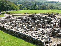
Hadrian's Wall ran between the fort Segedunum in today's Wallsend at Newcastle upon Tyne, just before the mouth of the Tyne in the North Sea, to the fort Maia at today's Bowness-on-Solway on the Solway Firth and extended for about 117 km. While in the east it consisted of a wall up to 5 m high and up to 3 m wide, in the western part mostly only an earth wall was heaped up. Like the Roman border fortifications on the Germanic Limes, Hadrian's Wall mostly ran straight through the landscape, pulling up and down the hills and conquering numerous vertical meters, especially in the high elevations of the northern Pennines. The wall was interrupted at regular intervals (1 Roman mile) by a total of 80 gates, which were connected by the so-called mile forts (milecastles) was protected. A total of 320 signal or watchtowers (turrets) the wall. There were also larger forts (continued) located a little further in the hinterland, where the majority of the troops lived and could be quickly mobilized to the current deployment points on the wall on the military roads laid out by the Romans.

Hadrian's Wall is still visible today in several sections, but often in rather inaccessible terrain, so that a visit to many places is associated with somewhat arduous marches. The foundation walls of numerous mile forts, watchtowers and forts are still in place. A trip along all of the Roman sights on Hadrian's Wall should therefore allow for sufficient time slots for sightseeing. Particularly striking is the section between Hexham and Gilsland, where the wall stretches imposingly on a chain of hills through quite rough terrain. But also the forts in the "more moderate" regions from Port Carlisle in the west to Wallsend in the east are worth seeing, even if the wall is often no longer preserved in the more heavily populated regions such as Newcastle in particular.
Hadrian's Wall is made accessible to tourists by various routes for motorists, cyclists and hikers, supported by a local transport system consisting of train and bus, which in the summer months is particularly geared towards the accessibility of the world cultural heritage sites. Since 1987 the plant belongs to the UNESCO world cultural heritage, and was expanded in 2005 by the sections of the Upper Germanic-Rhaetian Limes in Germany.
The last section documented in this article from Bowness-on-Solway to Ravenglass is no longer part of Hadrian's Wall. However, in the period that followed, the Roman troops built numerous fortifications on the coast of Cumbria down to Ravenglass, so that this section is also often referred to as part of Hadrian's Wall and, among other things, is also made accessible by the Hadrian's Cycleway.
getting there
The central entry point into Hadrian's Wall is for travelers from mainland Europe Newcastle upon Tyne at the east end of the wall.
By plane
Newcastle Airport![]()
![]()
![]() (IATA: NCL) is also served directly from German airports.
(IATA: NCL) is also served directly from German airports.

By train
National Rail offers train connections from all parts of the UK to Newcastle, including express trains from the north Edinburgh and Aberdeen and from the south London. Cyclists - subject to a reservation - can also take their bikes with them on the express trains, but due to the limited number of parking spaces it is advisable to reserve them in good time.
In the street
Drivers from mainland Europe reach Hadrian's Wall relaxed with the night ferry from DFDS Seaways. It takes 14 hours to get to the Ijmuiden ferry port Amsterdam to the North Shields ferry terminal near Newcastle upon Tyne, which is already in Tyne. Anyone who has come to the island via the more southern ferry ports or the Eurotunnel can reach Newcastle via the A1 Nottingham and Leeds coming.
In the opposite direction
Alternatively, Hadrian's Wall can of course also be walked on in the opposite direction, a suitable place to start is then CarlisleEither by train or by car via the M6 (from the south direction Liverpool/ Manchester, from the north Glasgow coming).
The Hadrian's Cycleway leads not only over the main route along the rampart, but also along the west coast of Cumbria and the Roman artifacts there. The place of entry into the entire route (or destination in the opposite direction) is then Ravenglass, which can be reached by train.
Routes
By bus
For travelers on Hadrian's Wall, the runs from March or April to the end of September City bus AD122. The bus commutes on the core route up to seven times a day Hexham and the Walltown Roman Army Museum, including Chesters, Housesteads and Vindolanda castles and the National Park Center Once Brewed on Military Road. The first and last bus of the day runs from to to Newcastle. Every second bus travels from Walltown via Birdoswald Castle and Lanercost Priory to Carlisle.
![]() The relatively small buses have space for one or two wheelchair users. If these spaces are not occupied, bicycles may also be taken along - cyclists have to get off if a wheelchair user wants to get on on the route. Anyone who wants to safely plan a section of the bus as a cyclist should register the day before by 3 p.m. on 44 14 34 32 20 02.
The relatively small buses have space for one or two wheelchair users. If these spaces are not occupied, bicycles may also be taken along - cyclists have to get off if a wheelchair user wants to get on on the route. Anyone who wants to safely plan a section of the bus as a cyclist should register the day before by 3 p.m. on 44 14 34 32 20 02.
By train
Northern Rail also serves as Hadrian's Wall Country Line designated route between Newcastle and Carlisle, whose trains at the stations Blaydon, Wylam, Prudhoe, Stocksfield, Riding Mill, Corbridge, Hexham, Haydon Bridge, Bardon Mill, Halt whistle and hold Brampton. If you want to get to the higher-lying sights of the wall from Newcastle later in the day (Housesteads, Vindolanda) and have missed the first bus on the AD122, take the train to Hexham and then change to the AD122.
In the street

From Newcastle you drive on the A69 to the west to Heddon-on-the-Wall, where the often visible section of the old Roman walls begins. From here you follow the B6318that is on the section up to Greenhead too Military Road is called because it corresponds to the course of the earlier Roman road. Alternatively, the side roads to the south are particularly suitable, as they lead through the villages where the remains of numerous auxiliary forts can be found. You leave the B6318 shortly after Gilsland in the direction of Birdoswald on a small side road that leads from Kastell Birdoswald to Banks again directly along the wall. Then the rampart leads to Carlisle almost continuously away from roads, so that one follows one of the two variants of the A69 to Carlisle. From Carlisle, the road, which is usually very close to the course of the ramparts, then leads via Burgh by Sands to Port Carlisle and to the end of the actual ramparts Bowness-on-Solway.
By bicycle

The Hadrian's Cycleway, also signposted as cycle route 72 of the National Cycling Network (NCN), runs 277 km from South Shields above Newcastle upon Tyne to Carlisle to the end of the wall Bowness-on-Solway, but then continues along the coast to the south along the coast of Cumbria Ravenglass. The cycle path does not always run along the wall, but often on traffic-calmed routes or cycle paths in the Tyne Valley, but also on some higher-lying routes in the Pennines Hexham, Gilsland and Birdoswald. However, if you really want to discover the loneliest stretches of the former wall course, you have to leave the route guidance at several points and go on the narrow, extremely hilly course of the Military Road B6318.
GPS track and route description in both directions for the bike path can be found in the Bike tour wiki.
On foot

The Hadrian's Wall Path runs for about 135 km / 84 miles, mostly in the immediate vicinity of the ramparts - it is only possible to experience the rampart authentically on foot. From the densely populated region around Newcastle, the route first takes you along the banks of the Tyne, then up to the northern foothills of the Pennines, first in the immediate vicinity of the Military Road, then from Chester on paths through lonely terrain. At Greenhead you leave the rougher regions and follow the rampart again, mostly near Military Road, via Birdoswald to Banks. After that, you rarely touch the course of the wall, but follow small paths to the right and left of the former wall until you come back to densely populated regions at Carlisle Airport. If you want to go the whole way, you can hike from Carlisle to Bowness-on-Solway, the small town at the end of Hadrian's Wall.
preparation
The individual preparation for the trip on Hadrian's Wall depends on the chosen mode of transport. Hikers and cyclists should plan a little more carefully in terms of accommodation and equipment than is necessary for travelers by car, as the latter can spontaneously switch to accommodation further away. Backpackers or Interrailers need to know the train connections with which they want to travel along the towns near the wall and, if necessary, also clarify the question of accommodation. Further preparation is generally not necessary, apart from the things that may be important for travelers from the continent to the British Isles (cars and cyclists should be prepared for left-hand traffic, an adapter for the British sockets can be helpful to prove indispensable, and British pounds should be in your wallet ...).
equipment
In general, Hadrian's Wall Path is also suitable for less experienced hikers, but due to the sometimes challenging terrain in the Hexham - Greenhead section, the route should not be underestimated. Good, ankle-high trekking shoes that are as waterproof as possible are probably sufficient, even if experience has shown that many hikers wear more stable mountain boots. Particular attention should be paid to adequate weather protection, wind and waterproof clothing is essential, especially in the higher regions of the path.
The same applies to cyclists, as they are just as exposed to the weather as hikers. Even in midsummer, the weather changes very quickly, and long-lasting rain showers that you do not want to wait for days in an accommodation are to be expected. In this case, weather protection and waterproof bags will probably increase cycling pleasure.
accommodation
On the relatively unpopulated section between Hexham and Greenhead, everyone traveling on their own should pre-book permanent accommodation sufficiently early - looking for accommodation in the late afternoon will probably work Newcastle and Carlisle, probably also in Hexham and Brampton, in the smaller towns and especially on Military Road it quickly becomes scarce if you don't want to take the last bus to other regions.
The youth hostels along the route in particular are often fully booked early. Travelers with tents are of course more flexible, due to the local weather conditions there are usually not so many tents on the road as hikers or cyclists would not be able to find a corner for their tent.
This article names some accommodations in less well-developed tourist regions that travelers only take for one night (mostly recognizable by the "Cyclists- / Walkers Welcome" sign). Further accommodations can be found in the relevant local articles and on the website of the Hadrian's Wall Path.
Route sections
South Shields - Newcastle upon Tyne


Motorist, those arriving by ferry from Amsterdam / Ijmuiden start halfway between the first Roman artifacts on the route (in Tynemouth or South Shields) and Newcastle. The North Sea Terminal is located in North Shields and therefore not far from the Segedunum Fort in Wallsend. If you want to start your journey at Arbeia Fort in South Shields, you have to cross the Tyne through the Tyne tunnel to Jarrow (10 km from the terminal). From Arbeia Fort to Newcastle City Center it is then approx. 20 km (again via the Tyne tunnel).
CyclistThose arriving by ferry will find excellent signage for the Hadrian's Cycleway (also known as NCN ![]() signposted) directly from the ferry terminal in North Shields. The start of the cycle path at Arbeia Fort can be reached either with the passenger ferry (Shields Ferry) a few 100 m east of the North Sea Terminal (Royal Quays North Sea Ferry Terminal) or through the pedestrian / cyclist tunnel (Tyne Pedestrian / Cycle Tunnel) under the Tyne a few 100 m west of the North Sea Terminal. Alternatively, you can cycle to the northern mouth of the Tynemouth and start the tour at Tynemouth Castle, following the signs for NCN 1 (North Sea Cycle Route). The Hadrian's Cycleway leads from North Shields for 16 km in the direction of Newcastle and runs largely along the route of a disused railway line above the Tyne.
signposted) directly from the ferry terminal in North Shields. The start of the cycle path at Arbeia Fort can be reached either with the passenger ferry (Shields Ferry) a few 100 m east of the North Sea Terminal (Royal Quays North Sea Ferry Terminal) or through the pedestrian / cyclist tunnel (Tyne Pedestrian / Cycle Tunnel) under the Tyne a few 100 m west of the North Sea Terminal. Alternatively, you can cycle to the northern mouth of the Tynemouth and start the tour at Tynemouth Castle, following the signs for NCN 1 (North Sea Cycle Route). The Hadrian's Cycleway leads from North Shields for 16 km in the direction of Newcastle and runs largely along the route of a disused railway line above the Tyne.
walkerThose who want to start their hike from the mouth of the Tane can take the from the airport or train station in Newcastle or from the ferry terminal in North Shields metro to Tynemouth (north bank of the Tyne) or South Shields (south bank of the Tyne). The official Hadrian's Wall Path begins at Segedunum Castle in Wallsend (metro station) and runs largely on the route of the Hadrian's Cycleway on a former railway line to Newcastle. Only in Walker Riverside Park and in the district of St. Peter does the hiking trail take a course closer to the river than the bike path. Stage length Wallsend - Newcastle (Tynebridge): approx. 12 km.[1]
By bus and train if you use the Metro in the Newcastle area and the Shields Ferry (runs every 30 minutes, crossing 7 minutes).
Places and sights
In this first section, the rampart or wall in the densely populated area of Greater Newcastle has not been preserved, so that the sights from Roman times are limited to fragments of forts and towers.
- 1 Arbeia Roman Fort, Baring Street, NE33 2BB South Shields. Tel.: 44 19 14 56 13 69, Email: [email protected]. The easternmost Roman fort on Hadrian's Wall, on the south bank of the Tyne was not part of the fortifications, but served to control the important port. At the same time, Arbeia was the central supply unit for the entire Roman troops on Hadrian's Wall. Located above the Tyne in South Shields, the excavation site with the striking reconstructed west gate gives an excellent impression of the dimensions of such a facility. In addition to the gate, the residential building of a commandant was also reconstructed, which with its numerous wall paintings gives an impression of the relative prosperity of the senior military of the time. A museum with a shop and an education center, which has set itself the task of conveying Roman life to schoolchildren, form the entrance to the fort area.Open: Open April - September Mon - Fri 10 a.m. - 5 p.m., Sat 11 a.m. - 4 p.m., Sun 2 p.m. - 5 p.m. Closed October - March, guided tours for groups possible by appointment.Price: Free access.
2 Tynemouth
- 2 Tynemouth Priory and Castle, Pier Road, Tynemouth, NE30 4BZ. Tel.: 44 19 12 57 10 90. The 2000 year old systems, directly on the north bank of the Tyne located at the mouth of the river in the North Sea, are not of Roman origin. It is still worth a visit. If you arrive by ferry from Amsterdam, you can already see the ruins from the sea.
- 3 North Shields
- 1 North Shields Ferry Terminal for North Sea ferries to Amsterdam-Ijmuiden
- 2 Pedestrian Ferry North Shields, Passenger ferry to South Shields
- The driveways to both 3 Tyne Tunnel North Shields as well as for 4 Access Pedestrian Tyne Tunnel North Shields (Pedestrian tunnel under the Tyne) are about halfway between North Shields and Wallsend.
- 4 Wallsend
- The name of the current suburb of Newcastle indicates that the ramparts ended (or began) here, on the remaining section to the mouth of the Tynes the river represented the border of the Roman Empire.
- 3 Segedunum Roman Fort, Baths & Museum, Buddle Street, Wallsend, NE28 6HR. Tel.: 44 19 12 36 93 47. Open: beginning of April to beginning of November Mon - Sun 10 a.m. - 5 p.m.
_-_geograph.org.uk_-_837950.jpg/220px-Hadrian's_Wall_and_Denton_Turret_(2)_-_geograph.org.uk_-_837950.jpg)
- In Roman times, the fort stood on the site of today's location Pons Aelius. Newcastle is worth a stop on the trip at Hadrian's Wall, among other things due to the numerous bridges over the Tyne, a walk over the Millennium Bridge leads to the neighboring town of Gateshead on the other side of the Tyne with the imposing event building The Sage. In addition, the place is the central transport hub of the region.
- 4 Benwell Roman Temple
- The fort too Condercum, now Benwell, was in the city of Newcastle. Here you can still find a Celtic relic, the Benwell Roman Temple on Broomridge Ave (Vallum Crossing) in Denhill Park, home to the Celtic deity Antenociticus was worshiped.
- 5 Turret 7B / Denton Hall Turret, Turret Road. The fragments of the Denton Turret (tower 7B) and a short piece of wall are in the West Denton district on Turret Road south of the A69.
accommodation
If you don't want to go straight after your arrival, you will find in Newcastle, in South Shields and a wide range of accommodation in all price ranges in Tynemouth. However, it only becomes less urban in the course of the first stage from Newcastle to the west in the small towns on the Wall and on the Tyne.
Newcastle upon Tyne - Hexham
motorist have the choice between two routes out of Newcastle, between which you can switch on small back roads at regular intervals. The B6318, the so-called Military Road, marks the course of Hadrian's Wall from Heddon-on-the-Wall and leads through largely unpopulated terrain to Greenhead, so that you have to turn on side roads to visit the villages. Alternatively, you can follow the A965 or the A69 (T) from Newcastle through the small towns south of the wall, where many Roman artefacts - forts or towers - or museums can be found. The length of the stage is approx. 35 km, depending on the route.

Cyclist be on Hadrian's Cycleway ![]() led away from the wall. This is primarily due to the better navigability of the route, but it may also simply prevent a "traffic obstacle" on the narrow, demanding B6318 for the numerous tourist buses caused by slow cyclists. When leaving Newcastle, cyclists should therefore consider which sight is their main interest: the course of the wall - then you have to explore the B6318 on your own, or the equally interesting villages on the Tyne with the opportunity to visit a number of forts - then you should follow the well-signposted cycle route. In Newcastle this runs along the promenade on the north bank of the Tyne, then briefly changes to an old rail route north of the A-Road and then follows the river to Wylam mostly continuously. Shortly before Wylam there is another old railway line, which you leave again shortly after crossing the Wylam Railway Bridge. As far as Prudhoe, it continues on the southern side of the Tynes on the bank. In Prudhoe over the bridge to Ovingham, then further on country roads with a number of small inclines without a cycle path to Corbridge and on to Hexham. Stage length Newcastle - Hexham: around 38 km.
led away from the wall. This is primarily due to the better navigability of the route, but it may also simply prevent a "traffic obstacle" on the narrow, demanding B6318 for the numerous tourist buses caused by slow cyclists. When leaving Newcastle, cyclists should therefore consider which sight is their main interest: the course of the wall - then you have to explore the B6318 on your own, or the equally interesting villages on the Tyne with the opportunity to visit a number of forts - then you should follow the well-signposted cycle route. In Newcastle this runs along the promenade on the north bank of the Tyne, then briefly changes to an old rail route north of the A-Road and then follows the river to Wylam mostly continuously. Shortly before Wylam there is another old railway line, which you leave again shortly after crossing the Wylam Railway Bridge. As far as Prudhoe, it continues on the southern side of the Tynes on the bank. In Prudhoe over the bridge to Ovingham, then further on country roads with a number of small inclines without a cycle path to Corbridge and on to Hexham. Stage length Newcastle - Hexham: around 38 km.
walker the walking path on the quayside leads through Newcastle and out of town together with the cycle path. At Bell's Close you have to cross a larger crossroads, then continue like the cycle path above the A6085 on the old railway line. From Lemington to Newburn on the local road, then back on the Tyne bank to just before Wylam, from where it goes north between some small settlements to Heddon-on-the-Wall. From now on, the Hadrian's Wall Path runs parallel to the B6318, the Military Road, until shortly after Chollerford. Stage length Tyne Bridge - Heddon-on-the-Wall: approx. 16 km, Heddon-on-the-Wall - Chollerford: approx. 22 km.
By bus and train Heddon-on-the Wall can only be reached with the first and last bus on line AD122 from Newcastle or Carlisle. Wylam, Prudhoe, Corbridge and Hexham are within the network of approximately hourly National Rail from Newcastle to Carlisle involved. From Hexham, the AD 122 bus commutes on to the Roman castles up to and including Wallstown Roman Army Museum up to seven times a day.
Places and sights

_-_geograph.org.uk_-_1246686.jpg/220px-Hadrian's_Wall_at_Planetrees_(3)_-_geograph.org.uk_-_1246686.jpg)
On Military Road:
- 1 Heddon-on-the-Wall
- 6 Wall section at WylamVisible wall section north of Wylam, on the B6582. The location of the Milecastle 12 is assumed to be on the site of a farm, but no superficial remains of it can be seen. The accompanying towers, Turret 12 A and 12 B, are also no longer visible, they are suspected to be at various points directly on the course of the Military Road.
- 2 Chollerford
- Just before Chollerford are at 7 Planetrees About 15 m of the (freely accessible) wall have been preserved, which document that the thickness of the wall was increasingly reduced in the course of the construction: On a wider foundation, here, as in many other places on Hadrian's Wall, a significantly narrower wall was ultimately built (free access) .
- a little to the west, accessible via a junction from the A6079, are the ruins of the 8 Brunton TurretBrunton Turret, a section of wall with the foundations of a watchtower (free access).
- further to the west, accessible via the A6079, are the remains of an abutment of the bridge over the North Tyne, known as 9 Chester's Bridge Abutment (free access). On the bridge, the path was led along the top of Hadrian's Wall across the river, around 670 AD. the stone blocks were used to build the church at Hexham.

_-_geograph.org.uk_-_1022140.jpg/210px-Barrack_blocks,_Chesters_Fort_(3)_-_geograph.org.uk_-_1022140.jpg)


_-_geograph.org.uk_-_809557.jpg/210px-Chesters_bridge_abutment_(2)_-_geograph.org.uk_-_809557.jpg)
- The remains of the fort Cilurnum can be found a little west of Chollerford on the B6318 near Chester:
- 10 Chester's Roman Fort and Museum, Chollerford, Hexham NE46 4EU. Tel.: 44 14 34 68 13 79. Ruins of the largest excavated cavalry fort, which had room for 500 cavalrymen. Roman thermal baths were excavated on the river. Local finds from Roman times are exhibited in a museum and information is given about the history of the excavations by John Clayton, some of the original display cases from his time are still present. Tea and small meals are available in a tea room.Open: April-Sept. 10.00-18.00, Oct-Nov. 10 a.m.-5 p.m., Nov-March only Sat, Sun 10 a.m.-4 p.m.Price: £ 5.80.
- About one kilometer after Chester on the B6318 there is another 460 m long piece of wall with the remains of a tower at the Black Carts settlement: 11 Black Carts Turret. Access free, but it is difficult for drivers to park on site!
In the valley of the Tyne:

3 Wylam .
- Small village south of Hadrian's Wall on the Tyne. Approx.2,000 inhabitants, the birthplace and place of work of some railway pioneers, to whom, among others, im George Stephenson's birthplace is remembered. Also worth seeing is the Wylam Railway Bridge, over which the Hadrian's Cycleway now runs. Rail connection.
- 4 Prudhoe '
- In the former mining town of just over 11,000 inhabitants, travelers have rail connections on the Newcastle - Carlisle route.
- Prudhoe Castle - Ruins of a medieval castle.

- 5 Corbrige
- The town with approx. 3,500 inhabitants goes back to a Roman city called Coria (or Coriosopitum or Corstopidum). Worth seeing is the medieval town center with the typical houses and the church of St. Andrew.
- 12 Corbridge Roman Town, Corbridge NE45 5NT. Tel.: 44 14 34 63 23 49. Well-preserved remains of the Coria Fort, which grew into a city after the construction of Hadrian's Wall. Somewhat outside of today's western outskirts.Open: April-Sept. 10 a.m.-6 p.m., Oct-Nov. 10 a.m.-5 p.m., Nov-March only Sat, Sun 10 a.m.-4 p.m.Price: £ 5.80 / children £ 3.40 / families £ 15.00.
- 6 Hexham
- Interesting medieval city without Roman roots, but with the one founded in 674, built in its present form in the 11th century Abbeythat laid the foundation for today's city of around 11,000 inhabitants. Rail connection on the Newcastle - Carlisle line and connection to the AD122 tourist bus.
accommodation
- On Military Road
- 1 Hadrian's Barn B&B, Edgehill Cottage, Hillhead, Heddon on the Wall, NE15 0EZ. Tel.: 44 79 44 00 46 01.
- . Small **** hostel with rooms for 2 - 5 people.
- . 3 rooms with a simpler standard, simple camping on a meadow by the pub (washrooms and toilets in the pub, only usable during pub opening times). Located about 8 km west of Heddon-on-the-Wall directly on the B6318.
- In the Tyne Valley accommodation can be found in the numerous small towns along the way: Wylam, Prudhoe, Corbridge, Hexham.
Hexham - Greenhead

The section from Hexham to Greenhead leads through the northern foothills of the Pennines, a very rough, hilly terrain that is particularly demanding of the hikers (and to a certain extent the cyclists).
motorist on the other hand, the undulating chain of hills, over which the so-called Military Road (B6318) mostly stretches as dead straight, can mostly be enjoyed more carefree, but should be more numerous along the sometimes narrow road blind summits and exercise some caution on many buses and campers. If you want to visit the small town of Haltwhistle, you can leave the B6318 at Once Brewed or the wonderfully angled Milecastle Inn and drive down into the Tyne Valley. Leg length Hexham - Greenhead via Chollerford and the B6318 approx. 35 km, through the Tyne Valley via Chesterwood and Haltwhistle (A69) approx. 30 km.


Cyclist leave Hexham on the south bank of the Tyne, follow North Tyne from Bridge End and soon after turn west onto the B6319. The Hadrian's Cycleway ![]() runs on this section a little below the Military Road and thus leaves out the facilities of Housesteads and the most impressive wall section. (Alternatives: On the B6318 as described above or on the hiking trail, which, with luggage, is only suitable for extremely die-hard cyclists and full-suspension MTBs - and even then you have to be carried in some cases.) Although you are not entirely up to date on the official NCN route 72 goes, from Fourstones there is a considerable ascent, the climax of which is reached at the Vindolanda Roman Fort. From Vindolanda there is a little detour down to Bardon Hill and near the railway line to Haltwhistle. After the village there is an ascent up to the Military Road, so that cyclists can still get an impression of this high-altitude road along the wall on the last kilometer. Shortly afterwards it goes downhill on the road-accompanying bike path to Greenhead. Almost all of the time you are on back roads without a cycle path. Stage length Hexham - Greenhead approx. 41 km.
runs on this section a little below the Military Road and thus leaves out the facilities of Housesteads and the most impressive wall section. (Alternatives: On the B6318 as described above or on the hiking trail, which, with luggage, is only suitable for extremely die-hard cyclists and full-suspension MTBs - and even then you have to be carried in some cases.) Although you are not entirely up to date on the official NCN route 72 goes, from Fourstones there is a considerable ascent, the climax of which is reached at the Vindolanda Roman Fort. From Vindolanda there is a little detour down to Bardon Hill and near the railway line to Haltwhistle. After the village there is an ascent up to the Military Road, so that cyclists can still get an impression of this high-altitude road along the wall on the last kilometer. Shortly afterwards it goes downhill on the road-accompanying bike path to Greenhead. Almost all of the time you are on back roads without a cycle path. Stage length Hexham - Greenhead approx. 41 km.
walker On the Hadrian's Wall Path you do not come to Hexham or Haltwhistle, but stay above the Tyne Valley on the foothills of the Pennines and a few kilometers after Chesters Roman Fort leave the B6318, which has been reliably accompanying you until then, and now come into unpopulated, rough terrain where supply options and accommodation are no longer close by. From here on you should have enough provisions at the latest and thought about the overnight accommodation. Only the museum at Housestead Roman Fort and a few small farmsteads are signs of today's civilization along this route. Auf halbem Weg durch diese urwüchsige Region zwischen Chollerford und Greenhead bietet sich die Jugendherberge Once Brewed und das angrenzende Hotel Twice Brewed als Übernachtungs- und Versorgungsmöglichkeiten an. Etappenlänge Chollerford - Once Brewed ca. 18 km, Once Brewed - Walltown Roman Army Museum ca. 10 km, Walltown - Greenhead ca. 6 km.
Mit Bus und Bahn bietet vor allem der Bus AD 122 Wanderern, die den Hadrian's Wall Path unterbrechen wollen oder müssen, eine Möglichkeit, aus der einsamen Wallregion nördlich der Military Road zurück in die "Zivilisation" zu gelangen. Etwa alle Stunde bis 1 1/4 Stunde fährt der Bus die Haltestellen am Chester Roman Fort, am Housesteads Roman Fort, am Nationalparkzentrum / Jugendherberge Once Brewed, am Vidolanda Roman Fort und am Milecastle Inn in Richtung Haltwhistle (bzw. retour Richtung Hexham) an, wo man jeweils Anschluss an die regionalen Bahnverbindungen hat.
Orte und Sehenswürdigkeiten
An bzw. nahe der Military Road:
- zwischen der Military Road B6318 und dem Wanderweg findet sich ein Wallabschnitt mit einem Mile Castle, der .


- the Housesteads Fort ist eines der besterhaltensten römischen Kastelle im Vereinigten Königreich, das bis zu 1000 Soldaten beherbergen konnte. Im Gegensatz zu anderen Festungen ist es direkt in den Hadrianswall einbezogen, hier befindet sich einer der eindrücklichsten Abschnitte des Mauerverlaufs.
- 14 Housesteads Roman Fort, Nr Haydon Bridge, NE 47 6NN. Tel.: 44 14 34 34 43 63. Geöffnet: April-Sept. 10.00-18.00h, Okt.-Nov. 10.00-17.00h, Nov.-März 10.00-16.00h.Preis: £6.60 / Kinder £4.00 / Familien £17.20 / Parking £4.00..
- Ein grosser Parkplatz und das Besucherzentrum mit Shop, Tearoom und Toiletten liegt an der B3618, von der Bahnstation Bardon Mill im Süden beträgt die Distanz ca. 4 Meilen. Vom Besucherzentrum führt ein etwas ansteigender Schotterweg die 500 m zum Gebäude mit dem Museum und dem archäologischen Gelände, der Weg auf dem Hadrianswall führt direkt durch das Gelände des Forts hindurch (Tickets beim Museum erwerben).
 Gehbehinderte können mit Sonderbewilligung (beim Besucherzentrum melden) bis zu einem kleinen Parkplatz beim Museum hinauffahren, im archäologischen Gelände muss man sich dann doch zu Fuss bewegen.
 - Erhalten sind Ruinen des Tors, des Prätoriums, Wohngebäude, Latrinen und ein Kornspeicher.
- Den Besuch des Housesteads Fort kann man gut mit einem Spaziergang entlang des Hadrianswall Wanderwegs verbinden; die Ausblicke zu den Seen Greenlee Lough und Broumlee Lough sind eindrücklich.
- Malerisch ist der Bereich des Walls beim 15 Sycamore Gap mit einem photogenen alleinstehenden Baum, etwas weiter westlich liegt ein weiteres Milecastle, das Castel Nick (Milecastle 39).
- the Vindolanda Roman Fort wurde an der Stanegate Road, der etwas südlich des Hadrianswalls verlaufenden ursprünglichen römischen Grenzstrasse als Festung und Garnisonsstadt erbaut. In verschiedenen Schichten konnten Bauetappen von frühen Holzforts bis zu mächtigen Steingebäuden unterschieden werden.


.jpg/250px-Vindolanda_fort,_UK_(15308390056).jpg)


- 16 Vindolanda Roman Fort, Chesterholm Museum, Bardon Mill, Hexham NE47 7JN. Tel.: 44 1434 344 277. Geöffnet: April - Sept. 10.00-18.00h, Okt., Feb.& März 10.00-17.00h, Nov. - Anfang Jan. 10.00-16.00h. Geschlossen Anfang Jan. - Mitte Feb.Preis: £6.75 (Kombi £10.50) / Kind £4.25 (Kombi £6.00) / Familie £20.00 (Kombi £32.00).
- Sehenswert sind in Vindolanda die Ruinen von Wohngebäuden und militärischem Hauptquartier, eine Thermenanlage, römische Tempelanlagen und zivile Wohnhäuser (im angrenzenden sog. "vicus"), dazu kommen Nachbauten eine römischen Tempels und des Hadrianswall in Erd/Holz/Steinbauweise. In einem Museum sind Funde aus der Umgebung ausgestellt, von besonderer Bedeutung sind die Vindolanda tablets, postkartengrossen Holztafeln mit privater Korrespondenz, die von Soldaten der Garnison und ihren Angehörigen mit Kohletinte geschrieben wurden. Einige der Originaltafeln wurden dem Museum vom British Museum als Leihgabe zur Ausstellung überlassen.
- 17 The Sill National Landscape Discovery Centre, Bardon Mill, Hexham, NE47 7AN. Tel.: 44 1434 341181. Das 2017 neu eröffnete Nationalparkzentrum versteht sich Informationszentrum, Labor und Bildungseinrichtung in einem und will insbesondere für die Natur und die Geschichte der Region und des Nationalparks am Hadrianswall sensibilisieren.Direkt am Infozentrum des sich vom Hadrianswall zu den Cheviot Hills, dem Kielder Water bis zur schottischen Grenze erstreckenden Northumberland National Park in Once Brewed liegt auch der Busstop der Linie AD122.

_-_geograph.org.uk_-_578886.jpg/250px-Turret_44b_(2)_-_geograph.org.uk_-_578886.jpg)
_and_Hadrian's_Wall_west_of_Walltown_Farm_-_geograph.org.uk_-_2784026.jpg/250px-Turret_45a_(Walltown)_and_Hadrian's_Wall_west_of_Walltown_Farm_-_geograph.org.uk_-_2784026.jpg)
- at verläuft der Wall ein längeres Stück gut sichtbar auf einer Hügelkuppe. Vom Parkplatz mit dem Steinbruchteich Cawfield Quary ist der Wall und das Milecastle 42 gut zu Fuss erreichbar.
- südlich der Great Chesters Farm finden sich die quadratischen im Luftbild gut erkennbaren Umrisse des Forts 19 Aesica Roman Fort, der Fussweg Pennine Way führt daran vorbei.
- vor bei am Turret 44B gelangt man bei den 20 Walltown Crags nochmals zu einem malerischen Abschnitt des Hadrianswall, wo dieser auf der Kuppe oberhalb einer steilen Abbruchkante verläuft. Das Milecastle 45 zeichnet sich auf dem Luftbild vom Untergrund ab, vom Turret 45A sind die Grundmauern erhalten.
- 21 Walltown Roman Army Museum. Tel.: 44 16 97 74 74 85. Geöffnet: Geöffnet täglich April - Sept. 10.00-18.00h, sonst 10.00-17.00h. Geschlossen etwa Mitte Nov. - Mitte Feb.Preis: £5.50 (Kombi £10.50) / Kind £3.25 (Kombi £6.00) / Familie £16.00 (Kombi £32.00).. Das Museum liegt am Ende der Anhöhe, bevor die Military Road abwärts nach Greenhead führt, etwas abseits an einer kleinen Stichstraße. Es wurde neben den Ausgrabungen des Kastells Carvoran errichtet, von dem im Südwesten kaum mehr als die Umfassungsmauer zu erkennen ist.
7 Greenhead:
- 22 Thirlwall Castle. Die Ruine des Thirlwall Castle liegt etwas abseits des Ortes und ist für Radler auf dem Hadrian's Cycleway aus einiger Entfernung sichtbar. Für Wanderer auf dem National Trail ist es nur einen kurzen Abstecher zu der Ruine. Das um 1330 entstandene Schloss wurde unter anderem aus Steinen des Hadrianswall erbaut.
Im Tal des Tyne:
accommodation

- 4 The Twice Brewed Inn, Once Brewed/Twice Brewed B6318 Henshaw, Northumberland NE47 7. Tel.: 44 14 34 34 45 34, Email: [email protected].
- 5 Hadrians Wall Caravan & Camp Site, Melkridge Tilery, Melkridge NE49 9PG. Tel.: 44 14 34 32 04 95, Email: [email protected].
- Cottages.
Greenhead - Carlisle

Ab Greenhead verläuft der Wall wieder durch gemäßigtere Regionenen, und bringt mit dem Birdoswald Roman Fort und den folgenden Turm-Fragmenten noch letzte eindrucksvolle römische Artefakte mit sich. Ab Banks dann verläuft der Wall weitgehend durch Felder, so dass zumindest Autofahrer (und erst recht die Radler auf dem Cycleway 72) nicht mehr in die Nähe des eigentlichen Wallverlaufs kommen.
Autofahrer folgen ab Greenhead nach Gilsland noch der B6318 und orientieren sich dann Richtung Brampton. Von der Anhöhe nach Gilsland hat man Ausblick auf die hier noch vollständig erhaltene Mauer links unterhalb der Straße. Kurz danach biegt man links ab auf eine Nebenstraße zum Birdoswald Roman Fort. Nach dem Fort führt die Straße für wenige Kilometer bis Banks direkt an der Mauer entlang, so dass man bequem vom Auto aus an die zahlreichen gut dokumentierten Fragmenten der Türme 49B bis 52A betrachten kann. Nach Banks geht es weiter nach Lanercost und von dort aus orientiert man sich für einen dem Wall am nächsten kommenden Verlauf Richtung Walton, Newtown und dem Carlisle Airport, der auf dem früheren Wallverlauf errichtet wurde. Auf direktem Weg fährt man von Lanercost nach Brampton und weiter über die A69 nach Carlisle. Auf dieser Route beträgt die Etappenlänge Greenhead - Carlisle ca. 34 km.

Radler folgen in Greenhead für kurze Zeit einer separaten Radwegtrasse, dann muss die hier unübersichtliche, kurvige B6318 bis Gilsland genutzt werden. Weiter folgt der Radweg ![]() der gleichen Route wie für Autofahrer beschrieben, mit einigen Anstiegen bis Birdoswald, danach recht flache Strecke bis Banks und dann abwärts in kurviger Wegführung über Lanercost und Boothby nach Brampton, und auf Nebenstraße etwas umwegig über Hayton und Warwick Bridge nach Carlisle. Weitgehend keine separaten Radwege. Etappenlänge Greenhead - Carlisle ca. 41 km.
der gleichen Route wie für Autofahrer beschrieben, mit einigen Anstiegen bis Birdoswald, danach recht flache Strecke bis Banks und dann abwärts in kurviger Wegführung über Lanercost und Boothby nach Brampton, und auf Nebenstraße etwas umwegig über Hayton und Warwick Bridge nach Carlisle. Weitgehend keine separaten Radwege. Etappenlänge Greenhead - Carlisle ca. 41 km.
Wanderer: Von Greenhead (der Ort selbst wird nicht direkt berührt) geht es nach Überquerung der B6318 auf direkter Strecke quer durchs Feld nach Gilsland und danach unterhalb der Straße im Tal an der streckenweise gut erhaltenen Mauer entlang zum Kastell Birdoswald (hier Jugendherberge). Von Birdoswald führt der Weg mal direkt an, mal etwas zurückgesetzt der Nebenstraße nach Banks, dann teilweise auf Nebenstraßen, teils auf Wegen über Walton und vorbei am Carlisle Airport, zum Schluss am Ufer des Eden entlang nach Carlisle hinein. Etappenlänge Greenhead - Birdoswald 5,5 km, Birdoswald - Banks ca. 5 km, Banks - Walton ca. 5 km, Walton - Carlisle ca. 18 km.
Mit Bus und Bahn kommt man in der Saison mit dem Bus AD 122 vier Mal täglich ab Walltown Roman Army Museum über Greenhead, Gilsland, Birdoswald Roman Fort, Lanercost Priory, Brampton, Crosby on Eden bis Carlisle bzw. in die Gegenrichtung. In Brampton und Carlisle haben Reisende Anschluss an die regionalen Zugverbindungen, darüberhinaus hat man Anschluss an den Fernverkehr von National Rail.
Orte und Sehenswürdigkeiten
,_Hadrians_Wall_(8751183618).jpg/220px-Milecastle_48_(Poltross_Burn),_Hadrians_Wall_(8751183618).jpg)

_(2)_-_geograph.org.uk_-_1359274.jpg/220px-Milecastle_49_(Harrow's_Scar)_(2)_-_geograph.org.uk_-_1359274.jpg)

9 Gilsland
- : das Milecastle 48 mit einem erhaltenen Treppenaufgang zum Wall und den gegen Norden gerichteten Befestigungen am Tor gilt als eines der besterhaltenen.
- es folgt der Wallabschnitt 24 Willowford Wall mit dem Fundamenten des Turret 48 A und B und den Befestigungen der römischen Brücke am Ostufer des River Irthing.
- der Hadrian's Wall Path überquert den River Irthing auf einem Steg und führt danach durch das Milecastle 49 auf der Westseite des Flüsschens, das Milecastle wird als 25 Harrows Scar bezeichnet. Interessant sind Inschriften von Centurios der Bautrupps und Phallussymbole im Mauerverlauf (190 & 374 m westlich der Westwand des Milecastle), welche mit Metalltafeln bezeichnet sind.
- 26 Birdoswald Roman Fort, Greenhead, Brampton CA8 7DD. Tel.: 44 16 97 74 76 02. Geöffnet: April - Sept. 10.00-18.00h, Okt.-Nov. 10.00-17.00h, in den Wintermonaten nur Sa, So 10.00-16.00h.Preis: £5.80 / Kinder £3.40 / Familien £15.00.; Besucherzentrum mit Shop, Café & Toiletten; museum mit einem Modell des Hadrianswalls in Originalgrösse.
- The Birdoswald Fort wurde als typisches "playing card fort" rechteckig mit abgerundeten Ecken erstellt, an der Notseite direkt in den Wall einbezogen. Die Nordostecke wurde beim Bau der modernen Strasse abgetragen, die restliche Umfassungsmauer mit ursprünglich sechs Toren, Eck- und Zwischentürmen hat überdauert, es fanden sich noch Reste von frühen Holzgebäuden. Das Farmgebäude mit seinem Turm im pseudo-mittelalterlichen Stil wurde 1858 erbaut und die Einfassungsmauer des Forts als "Schlossparkmauer" ausgegraben.
- in Westrichtung liegt nach 325 m der halb in die Mauer eingelassene 27 Turret 49b, der nur von der der Strasse abgewandten Südseite zu erkennen ist.
- vom Milecastle 51 ist nicht mehr viel zu erkennen, dafür liegen die Fundamente des Turret 51A, des 28 Piper Sike Turret nördlich der Strasse. Etwas weiter in ähnlicher Lage der 29 Leahill TurretLeahill Turret 51B.
- kurz vor Banks findet sich das Fundament des 30 Banks East TurretBanks East Turret südlich des Strassenverlaufs, am nahegelegenen Parkplatz kann gut angehalten werden. Vom Milecastle in Banks ist kaum mehr etwas zu sehen, im Ort Banks resp. Hare Hill noch ein Stück des Mauerverlaufs.
In der Folge ist vom Wall kaum mehr etwas erhalten, entlang des bekannten Verlaufs verläuft der Hadrian's Wall Path an Gehöften und Weiden vorbei bis Carlisle.
- 10 Banks
- Kleiner Ort mit zahlreichen römischen Fragmenten in der Umgebung.
- 11 Lanercost

- 31 Lanercost Priory. Tearoom. Von der Augustinerabtei aus dem 13. Jhdt. sind Kirchenschiff, Turm und Teile des Kreuzgangs erhalten.Preis: $3.90 / Kind £.20 / Familie £10.10.
- 12 Brampton
- 13 Hayton
- 14 Warwick Bridge
- 15 Carlisle
- Der etwa 72.000 Einwohner zählende Ort geht auf das römische Kastell Luguvalium zurück.
- Carlisle Castle: Die ab 1122 errichtete Burg hat zwar keine römischen Wurzeln, ist aber sehenswert unter anderem aufgrund ihrer beträchtlichen Bedeutung in der jahrhundertelangen Geschichte zwischen England und Schottland, unter anderem, da Maria Stuart, die Queen of Scots dort 1568 gefangen war.
accommodation

- Gilsland
- . Walkers-/ Cyclist-Welcome-Unterkunft.
- . Walkers-/ Cyclist-Welcome-Unterkunft.
- . Farmhaus direkt am erhaltenen Wall gelegen.
- Birdoswald
- Jugendherberge Birdoswald YHA, Birdoswald Roman Fort, Gilsland, Carlisle, CA6 7DD. Tel.: 44 77 39 08 56 76. Geöffnet: Geöffnet Anfang/ Mitte Juli bis Anfang/ Mitte Sept.
- Banks
- Einfaches Farmcamping für Wanderer und Radler, Quarryside, Banks, Brampton CA8 2JH. Tel.: 44 16 97 72 538. auch B&B.
- Lanercost
- . Walkers-/ Cyclist-Welcome-Unterkunft.
- Carlisle: Tourist-Information. Tel.: 44 12 28 62 56 00.
Carlisle - Bowness-on-Solway

Diese kurze Etappe führt von der Großstadt Carlisle bis zum Ende des eigentlichen Hadrianswalls in das kleine 100-Einwohner-Dorf Bowness-on-Solway am Solway Firth.
Autofahrer fahren auf der B5307 westwärts aus Carlisle nach Silloth, und verlassen diese im Ortsteil Belle Vue auf die Burgh Road Richtung Burgh by Sand und Bowness. Ca. 22 km.
Radfahrer folgen dem Hadrian's Cycleway ![]() , der durch Carlisle am Ufer des Eden entlangführt, und dann auf der gleichen Strecke wie die Autofahrer auf der Nebenstraße nach Bowness-on-Solway. Ca. 23 km
, der durch Carlisle am Ufer des Eden entlangführt, und dann auf der gleichen Strecke wie die Autofahrer auf der Nebenstraße nach Bowness-on-Solway. Ca. 23 km
Wanderer folgen ebenfalls - mit kleinen Abweichungen - der gleichen Route wie die Radfahrer und haben damit auch etwa 23 km zu bewältigen.
Mit Bus und Bahn ist es nicht ganz einfach, nach Bowness-on-Solway hin bzw. vom dortigen offiziellen Ende des Hadrianswalls zurück nach Carlisle zu gelangen. Ein Taxi Bus Service fährt dreimal täglich von Carlisle Railway Station nach Bowness (Haltestelle The Kings Arms Inn), und ebenso dreimal täglich in die Gegenrichtung, und hält auf der Rückfahrt auch in Port Carlisle und Burgh by Sands. Plätze in diesem Bus müssen spätestens 90 Minuten vor der Abfahrt telefonisch vorbestellt werden unter 44 75 92 76 35 03.
Orte und Sehenswürdigkeiten
- Burgh by Sands: Direkt am Verlauf des Hadrianswalls liegt der Ort mit ca. 1.150 Einwohnern, früherer Standort des römischen Kastells Aballava.
- Port Carlisle: Fischerdorf, eine Meile vor Bowness
- Bowness-on-Solway: Kleines Dorf am Solway Firth, westliches Ende des Hadrianswalls. Die St. Michael's Kirche des Ortes wurde im 12. Jahrhundert auf den Überresten des römischen Kastells Maia built.
accommodation
- Rosemount Cottage, Rosemount, Burgh by Sands, Carlisle, CA5 6AN. Tel.: 44 12 28 57 64 40, Email: [email protected].
- . Walkers/ Cyclists Welcome.
- The Old Chapel, Bowness on Solway, CA7 5BL. Tel.: 44 16 97 35 11 26.
Bowness-on-Solway - Ravenglass
Dieser Abschnitt verbindet einige römische Befestigungsanlagen, die nach dem Hadrianswall als Befestigung der Küsten errichtet wurden. Im wesentlichen ist es nur der Hadrian's Cycleway, der diese 162 km lange Strecke touristisch erschließt.
- Silloth
- Maryport:
- Workington
- Whitehaven
- Ravenglass:
- Ravenglass Roman Bath House. Geöffnet: Der Zugang ist jederzeit möglich, der Eintritt ist frei.
security
Explizite Sicherheitsrisiken sind nicht bekannt. Radler und Wanderer müssen natürlich die üblichen Vorsichtsmaßnahmen bei Schlechtwetter beachten, angemessenes Verhalten bei Gewitter sollte insbesondere bim Aufenthalt in den Hochlagen des Wallverlaufs bekannt sein. Ebenso sollten sowohl Wanderer als auch Radler berücksichtigen, dass sie oftmals in den regulären Straßenverkehr der Region integriert sind. Der Hadrian's Wall Path verläuft abschnittsweise direkt neben der Straße bzw. kreuzt diese häufig, der Hadrian's Cycleway nutzt in der Regel das Straßennetz der Region und verläuft nur eher selten auf einer separaten Radwegtrasse.
trips


Im Vereinigten Königreich gibt es noch zahlreiche weitere römische Artefakte, so dass eine Reise zu den römischen Sehenswürdigkeiten weder in Carlisle noch in Ravenglass enden muss. Zudem bieten sich für Wanderer und für Radfahrer zahlreiche Anknüpfungspunkte für weitere Wander- oder Radwege von verschiedenen Orten der beschriebenen Routen, die im Folgenden nur ansatzweise aufgezählt werden können.
Autofahrer finden von Ravenglass aus relativ naheliegende Artefakte: Z.B. am nördlichen Ende des Lake Windermere das Ambleside Roman Fort oder im Lake District National Park gelegen das Hardknott Roman Fort.
Radfahrer können den Hadrian's Cycleway bei Moor Row auf halber Strecke zwischen Whitehaven und Egremont gelegen verlassen und auf der NCN 71 quer durch Cumbria and Yorkshire zurück Richtung Ostküste fahren. Radler, die bereits bei Carlisle die NCN 72 verlassen wollen, können Richtung Norden weiter auf der NCN 7 durch die Regionen Dumfries und Galloway Richtung Glasgow and weiter to Inverness radeln. Auf direktem Wege führt die NCN 74 von Carlisle nach Glasgow. Zurück zur Ostküste gelangt man auf der südwärts führenden Route der NCN 7 über die Pennines nach Sunderland.
literature
Karten
- Hadrian's Cycleway. Ravenglass to South Shields. Cycle Route Map. 1:100.000. Sustrans 2011 (überarbeitete Ausgabe). ISBN 978-1-901389-61-6 .
- Detaillierte Karten des Ordnance Survey (1.25 000), auf denen sowohl der Wallverlauf als auch Turmfragmente und Kastelle mit Nummerierungen eingezeichnet sind:
- OS Explorer Map Newcastle upon Tyne, Sheet 316, Abschnitt South Shields - Corbridge
- OS Explorer Map Hadrian’s Wall, Sheet OL43, Abschnitt Corbridge - Birdoswald.
- OS Explorer Map Carlisle, Sheet 315 , Abschnitt Lanercost - Burgh-by-Sands
Web links
Individual evidence
- ↑ Alle in diesem Artikel angegebenen Distanzen am Hadrian's Wall Path wurden ermittelt nach OpenStreetMap, diese weichen deutlich nach oben ab von den auf der Seite des Hadrian's Wall Path angegebenen Entfernungsangaben.