| Latina | ||
 | ||
| Salutation | City of the twentieth century | |
|---|---|---|
| State | Italy | |
| Region | Lazio | |
| Territory | Pontine countryside | |
| Altitude | 21 m a.s.l. | |
| Surface | 277.62 km² | |
| Inhabitants | 126.161 (2016) | |
| Name inhabitants | Latin | |
| Prefix tel | 39 0773 | |
| POSTAL CODE | 04100, 04013, 04010 | |
| Time zone | UTC 1 | |
| Patron | St. Mark the Evangelist Santa Maria Goretti | |
Position
| ||
| Tourism site | ||
| Institutional website | ||

Latina is a city ofAgro Pontino, subregion of Lazio.
To know
Founded with the name of Littoria during the Fascist period on December 18, 1932, it is one of the youngest cities in Italy: it took on its current name on June 7, 1945. It is the second city in Lazio by number of inhabitants, second only to Rome.
Geographical notes
Latina is located in the heart ofAgro Pontino, in a largely flat area. The city center is located a few kilometers (about seven) from the Tyrrhenian coast, where the promenade of Latina Lido is characterized by the beaches of Capoportiere, Foce Verde and Rio Martino. Locations that can also be reached via a modern cycle path. The city is also located a few kilometers from the mountainous reliefs of the Lepini mountains.
When to go
Tourists populate the town especially in summer and, generally, during the weekends.
Background
The first stone of the new city, built in the Pontine area reclaimed in the Fascist era, was laid on June 30, 1932. Thus arose Littoria, the original name of the urban center. The town severely damaged by the bombing of the Second World War changed its name to Latina in 1946. The emerging center was at the center of the economic boom that occurred in the entire area, so much so that over the years it became the second most populous municipality in the Lazio.
How to orient yourself
How to get
By plane
In the municipal area there is the military airport named after Captain Enrico Comani and seat of the 70th Wing of the Italian Air Force.
By car
The city of Latina is connected to Rome through the ![]() Pontina. There
Pontina. There ![]() Via Appia and the
Via Appia and the ![]() dei Monti Lepini connect the municipal territory to the other areas of the Agro Pontino and Lazio.
dei Monti Lepini connect the municipal territory to the other areas of the Agro Pontino and Lazio.
On the train
The railway Rome-Formia it serves the Latina Scalo station, located about 9 kilometers from the urban center, connecting the city to the capital and the Tyrrhenian area.
How to get around
What see

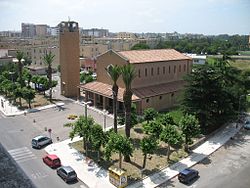
- 1 Cathedral of San Marco. Mother Church of the Diocese of Latina-Terracina-Sezze-Priverno. The church is dedicated to St. Mark the Evangelist and is located in the square of the same name, in the center of the city, not far from Piazza del Popolo and the Town Hall. The parish of the same name insists on it, entrusted to the priests of the Salesian Society of San Giovanni Bosco.


- Circeo National Park. Part of the northern territory of the Circeo park falls within the municipal area.
- Duilio Cambellotti Civic Museum. Located in the building of the former National Opera Balilla was established in 2005, the museum collects part of the numerous works of the artist Duilio Cambellotti including sculptures, drawings, woodcuts and ceramics. There are also books, medals and various documents on display.
- 2 Pontina Tower. Skyscraper inserted inside the business center of the city. In the rankings it is considered the seventh or tenth tallest skyscraper in Italy: seventh if we consider the antenna of 23 meters, tenth for the structure alone. The structure in Latina is one of a kind. Within the city, in fact, there are no skyscrapers or buildings as tall as La Torre Pontina.
Events and parties
- International circus festival city of Latina. Important event for the Italian youth circus movement that has taken place since 1999.
- Feast of San Marco Evangelista.
 25 April. Patronal feast.
 - Feast of Santa Maria Goretti. July 6. Patronal feast.