| Southern Marmara | |
 | |
| State | Turkey |
|---|---|
| Region | Marmara region |
Southern Marmara (in Turkish: Güney Marmara) is a region of the Turkey.
To know
Geographical notes
The southern Marmara occupies a long stretch of coast which is the southern one of the Sea of Marmara, the Marmara Islands off the coast and some places further inland. It borders the Eastern Marmara to the north-east and east, theCentral Anatolia to the southeast, theNorthern Aegean to the south and the Eastern Thrace to the north-west and north, across the Sea of Marmara and the Dardanelles Strait. In addition to the Marmara coast, the region also has a coast on the Aegean Sea to the west.
The Mount Uludağ with a national park and a winter sports resort, with its peak at about 2,500 meters above sea level, it is the highest mountain in the whole of northwestern Turkey and is located within this region.
This region, which occupies the northern and southern coasts of the great V-shaped Gulf of Edremit (Edremit Körfezi), is a less traveled alternative to the southern Aegean coast with silver-green olive groves everywhere. While there isn't much in the way of big cities or industries in the region - except, of course, the occasional olive oil factory - most of the coast is heavily built up, especially by summer homes from Turks from other regions. Indeed, the series of towns and summer houses that line the entire coast from Küçükkuyu to Ayvalıksi it can be argued that it forms a large urban agglomeration, albeit a little spaced out, low, leafy and quite deserted in winter. However, if you just take a step inland and you will quickly find yourself among grooves of centuries-old olive trees, cypresses and quaint villages with traditional stone architecture dotting the hills - the quintessential Mediterranean landscape.
Background

In ancient times, two thirds of the southern Marmara, roughly between Bursa is Balıkesir they were known as Misia, while the western part, a peninsula now better known as Biga Yarımadası in Turkish, between the Dardanelles, the Aegean Sea and the Gulf of Edremit, it was known as Troad, ie "the plains behind Troy". While the southern part corresponded to the ancient region ofEolia.
Territories and tourist destinations
Urban centers
- Akçay - City with frozen sea water and a starting point for visiting Hasanboğuldu waterfalls in the hills.
- Altinoluk - One of the main tourist resorts on the northern coast of the Gulf; the site of the ancient Antandros.
- Assos - Also known as Behramkale, a pleasant village with stone houses and the temple of Athena with impressive views over the Aegean.
- Ayvalik - Main city of the region with very elegant neoclassical and Greek architecture.
- Babakale - A village in the westernmost point of mainland Asia with a citadel.
- Balıkesir - Inland city, on the highway between Bursa is Izmir and the railroad between Bandırma and Izmir.
- Bandirma - A transport center with fast ferry connections to Istanbul and rail services for Izmir through the interior of the southern Marmara.
- Burhaniye - City with an interesting archaeological museum and a historic center.
- Edremit - City near the regional airport.
- Erdek - Seaside resort for families.
- Gallipoli
- Geyikli and Dalyan - The port on the mainland with ferries to the island of Bozcaada and the nearest village to the Alexandria Troad ruins.
- Gönen - City known above all for its thermal springs.
- Güre - City with thermal springs.
- Sindirgi - A city off the beaten track known for its local carpets.
- Çanakkale - City on the bank of the Dardanelles, a regional center for southwestern Marmara (Troad) since Troy, Gallipoli, Bozcaada they are a short distance away.
Other destinations
- Mount Uludağ - The highest mountain in northwestern Turkey, now a national park and winter sports resort.
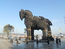
- 1 Troy —
 The famous archaeological site mentioned in Homer's Iliad.
Islands
- Bozcaada - A pleasant island with attractive architecture and cityscape.
- Marmara Islands - archipelago in the middle of the Marmara Sea with Avşa island frequented mainly by middle-class families.
Parks
- 2 Bird Paradise National Park (Kuş Cenneti Milli Parkı) - One of Turkey's earliest national parks, surrounding Bird Lake (In Turkish: Kuş Gölü, “Bird Lake”). It is an important stop and final destination for migratory birds, which migrate to warmer places to the south in winter. There are 239 species inhabiting the area during the summer and 3 million birds, although the whole area is only 64 hectares, tiny by world standards. What makes the area so popular with birds is its ecosystem: at the end of winter, with the rising water level of the lake (which is related to the rising of the streams, which in turn are linked to the melting of the snow in the mountains), a small grove of willows and reeds northwest of the lake that plunge underwater, making it a perfect area for nesting and for young to hatch and grow.
- The park has been awarded the European Class A Diploma by the European Council four times since 1976, thanks to its successful and effective wildlife protection.
- Detailed information about the birds, and about the park in general, is provided in the museum and administrative building within the park. The best months for bird watching are between March and July and September and October, which roughly corresponds to the migration period of the birds. There is a watchtower which commands a large area for viewing. Scientific research in the park requires permission from the park management.
- There are no food or lodging facilities inside the park. The closest community to the park is the village of Sigirciatik. Bandirma it is the nearest larger city. The park is located 20km southwest of Bandirma and approximately 50km north of Balikesir. It is easily accessible via the Bandirma-Balikesir highway.
How to get
By plane
Airport of Yenişehir (YEI IATA), Airport of Çanakkale (CKZ IATA).
By car
The highway D550 / E87 connects the region with theNorthern Aegean is Izmir further south, however, drivers with some time to spare may prefer the narrower, less busy parallel along the coast. There D575 / E887 to the east, however, connects Bursa with Istanbul is İzmit North.
From Istanbul, there are many fast ferry services to cities along the south coast, such as Armutlu , Güzelyalı near Bursa , Mudanya is Bandırma. The Marmara Islands they are also served by ferries from Tekirdağ through Marmara. There are also very frequent ferry connections between Çanakkale (see article on Çanakkale for details) and cities on the northern European banks of the Dardanelles, such as Eceabat is Gelibolu.
On the train
The only rail link with the region is from Izmir, from which trains leave for Balıkesir is Bandırma.
How to get around
By car
The highway D200 (which is assigned the European route number E90), which starts from Çanakkale and then passes through the regional centers of Bandirma is Bursa, to then leave the region to the east, is the backbone of transport in the region.
What see
Itineraries
- Along the Troad coast - It is a connecting route Çanakkale with Ace in the North Aegean through a number of historic sites along the coast
What to do
All of southern Marmara, from Kestanbol near Geyikli west to Çekirge to Bursa to the east, it is dotted with hot Springs (kaplıca).