| Matabeleland | |
 | |
Location 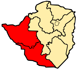 | |
| State | Zimbabwe |
|---|---|
| Surface | 129,197 km² |
| Inhabitants | 1.356.238 (2002) |
Matabeleland is a region of Zimbabwe inhabited by the Ndebele people from the mid-nineteenth century.
To know

Elephants at Hwange National Park
Territories and tourist destinations
Urban centers
- 1 Binga - Port city on the shores of Lake Kariba.
- 2 Bulawayo - The second most populous in the country after the capital Harare.
- 3 Gwanda - Capital of the province of Southern Matabeleland.
- 4 Lupane - Capital of the province of Northern Matabeleland.
- 5 Victoria Falls - The town closest to the Victoria Falls.
Other destinations
- 1 Victoria Falls - Breathtaking waterfalls located on the border between Zambia and Zimbabwe, part of the heritage ofUNESCO.
- 2 Khami - Ruins of the capital of the Torwa dynasty (1450-1683).
- 3 Hwange National Park - Zimbabwe Reserve, located on the border with the Botswana, in the western corner of the country. It was the hunting reserve of the supreme leader of the Ndebele people.
- 4 Matobo National Park - Area protected byUNESCO composed of granite hills and tree-lined valleys located about 35 kilometers south of Bulawayo.

Victoria Falls seen from above
How to get
How to get around
What see

Isolated granite hill (Monadnock) in Mbalabala
- Rock formations at Mbalabala (o Dance Dance).
What to do

Campsite at Matobo National Park
At the table
Safety
Other projects
 Wikipedia contains an entry concerning Matabeleland