 | ||
| Mont Ventoux | ||
| region | Provence-Alpes-Côte d'Azur | |
|---|---|---|
| Residents | unknown | |
| no value for residents on Wikidata: | ||
| height | 1,912 m | |
| no tourist info on Wikidata: | ||
| location | ||
| ||

The Mont Ventoux is a prominent mountain in the department Vaucluse in the French Provence.
background
The distinctive pyramid of the Mont Ventoux is one of the three most characteristic mountains of Provence and forms a language (between north and south Occitan) and also climatic boundary (between temperate and Mediterranean climate), the Mistral, which blows down the Rhône valley practically all year round, gave it its name.
In addition to its tourist importance (hiking, cycling and motor sports), the Mont Ventoux also became UNESCO - Biosphere Reserve explained.
history

A wind deity was probably worshiped on the wind-swept "Mons Ventosus" as early as Celtic times; that of the Italian poet and humanist Francesco Petrarch literary description of the first ascent of the Mont Ventoux is considered to be a significant threshold in the transition from the Middle Ages to the Age of Enlightenment, at least as the "hour of birth" of alpinism, in which nature was given a new status as an inspiring creation and field of natural science.
In the 15th century was near the summit the Chapelle Sainte-Croix built, of which only the apse remained after the wars of religion.
In the centuries that followed, Mont Ventoux saw its flanks being deforested in favor of the building of warships in Toulon and reforestation. A meteorological observatory was inaugurated in the summit area around 1882, and a section of the Resistance formed in the area of Mont Ventoux during World War II.
On the access road to Mont Ventoux, built in 1885, the first one was opened in 1900 Automobile racing carried out with three participants, later in the races organized by the Avignon Automobile Club, categories of engine rims and sidecars were run. After already at the beginning of the 20th century. Bicycle races were held, the Mont Ventoux was first used in 1951 by the Tour de France crossed, since then belongs to Ventoux again and again to the tour program. The last hairpin bends below the summit in the scorching barren scree area achieved sad fame due to the stimulants and overloading Doping death of the British driver Tom Simpson in 1967.
On the Ventoux there are also marathons resp. Half marathons carried out, it's more leisurely on the paths of the Grandes Randonnéeswho have favourited long-distance hiking trails GR4 and GR9 lead across the Ventoux. Since about 1925 it has been Mont Serein a ski area.
landscape
.JPG/220px-P1000549_(2).JPG)

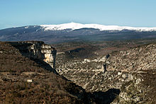
The 1912 m high pyramid of Mont Ventoux shows steeper slopes to the north than to the south, the summit is strong against the wind (especially the cool, often strong blowing from the north Mistral blanc) exposed. After extensive deforestation (for logging for shipbuilding, charcoal and firewood), the flanks have been reforested in recent decades, the summit region with fine rubble is still bare and shimmers brightly (even if the snow has melted after May).
On days with good visibility, the peaks of the Alps, the Pyrenees and the Mediterranean should be visible from the Ventoux, the view of the Rhone Valley in the west and the next highest peak in the region is impressive, Signal de Lure.
Flora and fauna
Pine trees, cedars (including Lebanon cedars) and fir trees grow on the reforested slopes of the Ventoux, while olive trees, oaks and nut trees grow on the slopes rising from the flatlands.
The flora changes from the Mediterranean flora in the lowlands to certain arctic plants in the summit region, the whole region of the Ventoux was called Biosphere reserve placed under protection. Also worth mentioning are the lavender fields on the rising mountain slopes and the truffles, which are valued by gourmets.
In addition to wild boar, red deer are native to the slopes, the wolf spreads its territory from northern Italy over the southern Alps in the direction of the Ventoux and has already been sighted 20 km away. Numerous birds of prey have been sighted in the Ventoux massif.
climate
In the summit region, the Mediterranean climate prevailing on the southern slope changes into a pre-Alpine climate dominated by the wind conditions: on 240 days a year an extremely stormy wind blows on the Ventoux, the Mistral blanc from the north along the Rhône valley sweeps the sky 150 days a year, the Mistral noir from the east brings clouds and the Marin from the south brings rain clouds from the Mediterranean, which then empty on the Ventoux massif. The Ventoureso brings cooler air as a cool breeze from the Ventoux to the Camargue in summer.
The summit is often shrouded in fog in the winter half of the year, while it soon becomes warm in the valley basin, there is still snow 150 days a year at the summit on the Ventoux.
getting there
In the street

The easiest way to get to the Mont Ventoux region is on the A7 - Autoroute du Soleil about the ![]() 22 or
22 or ![]() 23 above Carpentras.
23 above Carpentras.
The approach from the southwest is via the D974 of Carpentras above Bédoin to the summit, from the southeast the unites D164 out Sault - Apt with this road, which leads in the distinctive bends to the summit.
The approach from the northwest is via Malaucène and on the D9 - Route du Mont Serain past the winter sports resort Mont Serein on the more wooded north flank to the summit.
The trip to the Ventoux is classic on the bike on one of the three routes most frequented by the Tour de France are the 21.6 km Bédoin with a height difference of 1,610 m; the north approach to Malaucène with its 21 km and a gradient of 1,570 m is challenging with gradients of up to 12%, but less exposed to wind. The easiest way to do the 26 km and 1,220 meters of altitude difference on the east route from Sault.
Fees / permits
no
mobility
In the Ventoux massif, you can get around on foot, by bike / mountain bike or for "sight seeing" with a motor vehicle.
Tourist Attractions


- the 1 observatory in the summit area, the meteorological observation station with the television transmitter housed in the same building.
- the 2 Memorial to the cyclist Tom Simpson, who died here in 1967 of heart problems as a result of doping and heat shortly before reaching the summit on Mont Ventoux.
- the 3 Chapelle Sainte-Croix, of which actually only the original apse has been preserved.
activities

- hike, among others lead the long-distance hiking trails GR4 / GR9 on the Mont Ventoux. Birds and others can walk, especially in the wooded sections of the biosphere reserve Animals observed and rare plants can be found.
- a classic is the trip to Mont Ventoux with the Racing biketo better relate to the suffering of the Tour de France riders, or to tackle different slopes by mountain bike (in France "VTT" "- Vélo tout terrain").
- Winter sports (alpine and cross-country skiing) can at the Station du Mont Serain are operated, here mainly skiers from the wider area meet. For winter sports enthusiasts from German-speaking countries, there are probably more extensive and more demanding ski areas in the Alps.
shop
There are shopping opportunities in the villages at the foot of the Ventoux, in Bédoin, Malaucène and SaultYou cannot go shopping on Mont Ventoux itself.
The wine is worth mentioning Côtes du Ventoux AOC from the municipalities at the foot of the Ventoux.
kitchen
- the
accommodation
Around Bédoin there are numerous campsites, B & Bs and hotels on the Website of the place are listed.
camping
Most of the camping sites are only operated seasonally:
- 1 Camping Gîtes du Mont Serain, Camping Le Mont Serein, 84340 Beaumont-du-Ventoux. Tel.: (0)4 90 60 49 16, Email: [email protected].
- 2 Camping Municipal la Pinède, 502 Chemin des Sablières, 84410 Bédoin. Tel.: (0)4 90 65 61 03, Fax: (0)4 90 65 95 22, Email: [email protected].
- 4 Camping du Domaine Naturiste de Bélézy, Chemin de Bélézy, 84410 Bédoin. Tel.: (0)4 90 65 60 18, Fax: (0)4 90 65 94 45, Email: [email protected]. Naturist campsite.
- 5 Camping Le Pastory, 1105 Route de Malaucène, 84410 Bédoin. Tel.: (0)4 90 12 85 83, Email: [email protected].
- 6 Camping la Garenne, La Garenne, 84410 Bédoin. Tel.: (0)6 24 94 06 25, (0)4 90 65 63 05, Fax: (0)4 90 65 63 05, Email: [email protected].
- 7 Camping le Ménèque, Chemin de Ménèque, 84410 Bédoin. Tel.: (0)4 90 65 93 50, Fax: (0)4 90 12 83 61, Email: [email protected].
- 8 Camping Municipal "Aquisian ben", 163 Route de la Gabelle, 84410 Flassan. Tel.: (0)4 90 61 81 22, Fax: (0)4 90 61 94 46, Email: [email protected].
Hotels and hostels
security
The security situation in this rural region of Provence is harmless; in the case of longer absences, no valuables should obviously be left in the vehicle.
trips


- to Vaison-la-Romaine and orange with the monuments from Roman times
- to Carpentras
- to the Vaucluse - source in Fontaine-de-Vaucluse
Gorges de la Nesque
The gorge of the river Nesque, which dried up in summer, has dug itself 400 m deep into the limestone and runs from Monieux to Methamis. The street D942 - Route de Nesque of 1 Monieux to 2 Villes-sur-Auzon leads through the uninhabited gorge.
From 4 Belvedere At an altitude of 734m there is a beautiful view of the gorge and the opposite one Rocher de Cire, which was sung about by the Provencal poet F. Mitral.
In the canyon floor were at Bau de l'Aubesier Settlement remains from the time of the Neanderthals discovered (not accessible). It is also worth seeing 5 Chapelle de Saint Michel at the bottom of the ravine. The chapel from the 12th century. has been renewed repeatedly, the apse is in the manner of a grotto church under a ledge. The caves above the chapel, which were used in prehistoric times, can be climbed by those with a head for heights, especially after rain the accesses are slippery and only recommended for hikers with a head for heights.
literature
Websites
- Website by Vaucluse Tourism, among others in German