| Central Namibia | |
 | |
| State | Namibia |
|---|---|
Central Namibia it is a region that includes the capital Windhoek, on the plateau and the cities of Swakopmund is Walvis Bay
To know
Territories and tourist destinations

Urban centers
- Gobabis - Capital of Omaheke, one of the 13 administrative regions of Namibia, Gobabis is located east of the capital at a distance of about 200 km.
- Henties Bay - Holiday resort for Namibians and South Africans, particularly renowned for its pristine beaches and as a paradise for sport fishing.
- Swakopmund - City on the coast founded in 1892 by the Germans. From the colonial period it has preserved monuments in the style of the time, the Jugendstil. The road that leads you from the capital, the "B2 Road" is entirely asphalted and provides easy access to Mount Spitzkoppe, the Matterhorn of the Namibia.
- Walvis Bay - About thirty km further south of Swakopmund, Walvis Bay is a major fishing port.
- Windhoek - is located on the plateau in a central position with respect to the rest of the country.
Other destinations
- Canyon of the Kuiseb River - It meets along the state road C14 from Walvis Bay to Solitaire, at the height of the Gamsberg mountain pass. During the dry season, however, the river bed is dry. The novel "The sheltering Desert" by the German Henno Martin is set in Kuiseb Canyon.
- Cape Cross - Promontory of the Atlantic coast of Namibia. The place where the Portuguese navigator Diego Cao landed in 1486, the first European to set foot on today's soil Namibia. Near the cape there is a colony of sea lions.
- Ugab River - The course of the Ugab River offers opportunities for close encounters with black rhino specimens. If this ever happens, you should take the appropriate precautions because the mammoth animal could load the car and overturn it.
- Moon Landscape - Lunar landscapes a short distance from Swakopmund.
- Spitzkoppe - Mountain formation consisting of several granite peaks located between Usakos is Swakopmund, in Namib desert said "the Matterhorn of the Namibia".
How to get
By car
Central Namibia is crossed from north to south by the B1, a mostly two-lane (sometimes even four) main road that often goes straight for miles.
How to get around
What see
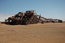
- Toscanini area - A former abandoned mining town whose rusty structures line the road.
Itineraries
The central coast

From Swakopmund it is possible to go up the stretch of coast to the north up to Torra Bay thanks to the C34, a road with a particularly slippery surface. It constitutes a protected area under the name of "National West Coast Tourist Recreation Area". It is not allowed to stay overnight inside. The locations on the C34 route are (distances from Swakopmund in brackets): Henties Bay (70 km), Cape Cross (119 km), the Ugab river (201 km), Toscanini area (248 km) and Torra Bay camp site (310 km) the end of the journey. In fact, beyond it extends a private reserve whose access is forbidden. In order not to go backwards on the itinerary, you could take the demanding mountain road that leads to the plateau of Damaraland. You leave the Springbokwasser gate before sunset.
From Windhoek to Swakopmund and Walvis Bay
From capital to the city of Swakopmund there are 360 km, from this one up to Walvis Bay another 35 km. The B2 national road runs through the rolling landscapes of the Namib Desert.
From Windhoek to Buitepos
200 km from Windhoek meet Gobabis on the B6 which continues and ends a Buitepos, border crossing with the Botswana. On the Botswana side, the road changes its name to A2.