| Nanga Parbat نانگا پربت | |
 | |
| State | Pakistan |
|---|---|
| Region | Gilgit-Baltistan |
| Mountain range | Himalaya |
| Height | 8,126 m a.s.l. |
Nanga Parbat (Urdu: نانگا پربت) is located in the Pakistan, in the chain ofHimalaya.
| ATTENTION: Some of the contents shown could generate dangerous situations or damage. The information is for illustrative purposes only, not exhortative or didactic. Use of Wikivoyage is at your own risk: read the warnings. | |

To know
It is the ninth highest mountain in the Land and the second eight thousand (after theAnnapurna) by mortality index, i.e. the ratio between the number of victims and the number of climbers who reached the summit, with a value that is around 28%, so much so that it is often nicknamed the killer mountain (the killer mountain).
Geographical notes
The mountain is set on a long main ridge, which completes a long arc with the concavity facing north-west. The arch originates in the north-east, with the Chongra ridge, which rises in a southwest direction to Chongra Peak (6828 m) and its secondary peaks (central Chongra Peak 6455 m and southern Chongra Peak 6488 m) and continues up to nodal point of Rakhiot Peak (7070 m). Here the ridge turns west reaching the Dente d'Argento Est (7530 m) and then bends west-south-west touching the Anticima (7910 m). From this point it turns directly south, touching in succession the Spalla (m 8070), the main peak (m 8126) and the Cima Sud (m 8042). From the latter, the ridge initially lowers towards the south-west, then continues for a long time towards the west always around 7000 meters with the name of Cresta Mazeno, after which it rotates to the north-west going to run out on the bottom of the Diamir valley . The Mazeno ridge is considered the longest in the world.
Flora and fauna
High-altitude areas are made up of coniferous forests, while in areas with little sunlight there are birches and dwarf willows.
Among the mammals, there are some brown bears and musk deer, endangered species.
When to go
The recommended period is summer, with departures from March to September / October, in order to enjoy the best climatic conditions at high altitudes.
Background
Nanga Parbat attracted climbing attempts relatively early. In 1895 Albert Mummery led an expedition that reached 7,000 m from the Diamir side. He later died along with two Gurkhas while attempting to explore a way to cross the Rakhiot side. The first ascension was made on 3 July 1953 by the Austrian mountaineer Hermann Buhl with an Austro-German expedition led by Karl Maria Herrligkoffer. The chosen slope was the Rakhiot to the north-east, passing through the Sella d'Argento and the SilberPlateau. This is the first and only 8000m peak reached by a single climber and without the use of oxygen.
Reinhold Messner and his brother Günther in June 1970 were the first to conquer the summit climbing from the difficult southern slope (also the first Italians ever on this mountain), the Rupal; However, Günther was hit by an avalanche and died.
Territories and tourist destinations
Urban centers

How to get
Entry requirements
- Passport and entry visa issued by the Pakistani Embassy of Rome or from the consulate of Milan for 30 or 90 days with a validity of 3 months.
- Trek permits in Pakistan issued by the Pakistani Ministry of Tourism, which decided to abolish the climbing permit (climbing permit) and the fee for the right to climb (royalty) of peaks up to 6500 m high. in order to promote trekking and mountaineering. The Ministry of Tourism has established three types of areas for trekking: open areas, restricted areas and closed areas.
- foreigners can make treks and excursions in any part of the open areas without the need for a permit for trekking from the Ministry and without an authorized mountain guide;
- for restricted areas: trekkers must have permission from the Ministry of Tourism, which can be obtained through any local tour operator; the cost is 50 US $ per person, you have to complete the formalities, the preventive meeting and the consultative meeting on returning from the trek at the Ministry of Tourism;
- in closed areas hiking or trekking is prohibited: these areas are located near the border between Pakistan and Afghanistan and close to the control line with the del Kashmir.
By plane
By car

.jpg/220px-Black_Pool_Reflection_(7275733762).jpg)
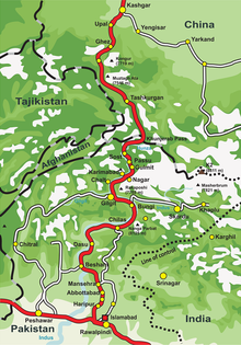
Follow the Karakorum road from Islamabad to Chilas (about 12 hours), continuing for 2 Raikot Bridge (2 hours), starting point at 1,280 m. of the approach path to the base camp on 4x4 off-road vehicles. Here climbs one of the most dangerous roads in the world, la Fairy Meadows Road that for 12. km. and in about 2 hours it leads to 3 Tatto Village, from which it is necessary to proceed on foot to reach the base camp of Nanga Parbat.
By bus
Bus service carried out by NATCO, among the main cities of the Karakorum Road.
Specialized agencies in Italy
- Focus Himalaya Travel, Corso Cristoforo Colombo, 10 - Milan, ☎ 39 02 89402052, @[email protected]. Organize trips, trekking and mountaineering in different parts of the world.
Specialized agencies in Pakistan
- Nanga Parbat Adventure, Apartment # 202, Islamabad Heights, E-11/4 - Islamabad, ☎ 92 51 237 5065, @[email protected]. Tourist company that offers services for mountaineering expeditions, trekking tours and mountain jeep safaris.
- North Pakistan Adventure, P.O Box 746 - Islamabad, ☎ 92 51 251 0374, @[email protected]. Specialized in treks, cultural tours, jeep safaris, walking tours, mountaineering expeditions to high mountains, ski tours in Pakistan.
How to get around
What see
What to do

- 1 Trekking to the base camp (Raikot slope). Challenging tourist route very popular with Pakistanis. From Tatto Village, the last place accessible with 4x4 motor vehicles, continue the march towards 4 Fairy Meadows ("fairytale meadows") (3,300 m.) Declared a national park by the Pakistani governp, reachable in 3-4 hours on foot. Here there is the possibility of sleeping in the cottage. The path then leads to the 5 Nanga Parbat Base Camp (3,967 m), arrival point after about 10 hours of walking: in front of the grandiose Raikot face of Nanga Parbat.
Shopping
Where to eat
Where stay

- 1 Fairy Meadows Cottages, Gilgit Baltistan, ☎ 92 301 4493725, @[email protected]. Small wooden houses with a view of Nanga Parbat. Availability of Pakistani and European meals.
- Campsite "Raikot Serai", Fairy Meadows.
Safety

The altitude sickness it also affects young and healthy people and is a real problem in the area. If you feel dizzy, have palpitations or have severe headaches, it is necessary immediately return to a lower altitude. Don't take altitude sickness lightly - it can cause death too!
How to keep in touch
Around
Recommended reading
- Michele Dalla Palma, Trekking: Guide with the best itineraries in Italy and in the world, Hoepli, 2009.
Other projects
 Wikipedia contains an entry concerning Nanga Parbat
 Commons contains images or other files on Nanga Parbat