| Karakorum road | |
 | |
| Itinerary type | Automotive |
|---|---|
| State | |
| Start | Hasan Abdal |
| end | Kashgar |
Karakorum road (Karakoram Highway - KKH) or National road N35 it is an itinerary, sometimes at high altitude, about 1300 km long. which takes place from Pakistan to China.
| ATTENTION: Those who travel the KKH take into account the unexpected: landslides, floods, snowfalls and monsoons in summer. In recent years, this street has become a tourist destination for adventurous travel. | |
Introduction
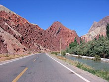
And the highest international asphalt road in the world. It is classified as the eighth wonder of the world and one of the most beautiful destinations in the world. The KKH was built by the governments of Pakistan and China and was completed in 1978 after about 20 years of construction. Several hundred Pakistani and Chinese workers lost their lives during the works, mainly in landslides and falls. The KKH route follows one of the many routes of the Silk Road. It connects China to Pakistan by crossing the mountain range of Karakorum, surpassing the Khunjerab pass at an altitude of 4,693 meters which makes it by far the highest paved road in the world that crosses an international border. The road, which connects the Northern Territories of Pakistan to the ancient Silk Road, is about 1,200 km long from Kashgar in the Chinese region of Xinjiang, to Havelian in the district of Abbottabad of Pakistan. The continuation of the road meets the Grand Trunk Road to Hasan Abdal, west of Islamabad. A large portion of the road runs through the northern areas of Pakistan. KKH allows expeditions access to most peaks in northern Pakistan and numerous mountains in Xinjiang. This region includes some of the largest glaciers in the world, such as the Baltoro Glacier. Five of the 8000 (mountains that exceed 8,000 meters in height) found in Pakistan are accessible via the KKH, in one way or another. There are more than 20,000 specimens of petroglyphs and rock art along the KKH in northern Pakistan, which are concentrated in ten major sites between the Hunza and Shatial rivers. The carvings were left by various invaders, traders and pilgrims who crossed this route, as well as by locals. The oldest date back to the period between 5,000 and 1000 BC, and show animals, stylized men and hunting scenes in which animals are much larger than humans. These carvings have been carved in the rock with stone tools and are covered with a thick patina that proves their age.

How to get
By plane
- Benazir Bhutto International Airport Islamabad.
How to get around
Bus service, among them the NATCO, between the major cities of the KKH and from Rawalpindi is Lahore. In March 2006, the respective governments announced that from 1 June 2006 a daily bus service would cross the border between Gilgit, Pakistan and Kashghar, China, and that expansion works would begin on 600 km of the road.
Preparations
Obtain entry visas in advance. The road gave climbers easy access to the area's many mountains, glaciers and high-altitude lakes. The Karakorum Road allows for easy overland access to Gilgit is Skardu from Islamabad. These are the two main centers for mountainous expeditions in northern Pakistan. The "9/11" events had the side effect of reducing tourism in the area, as Pakistan has since been advised against as a tourist destination. Non-English-speaking tourists, including many Europeans, are starting to frequent these areas again while Brits and Americans are still rare due to the permanent, if isolated, bad reputation.
Stages
Pakistan
- 1 Hasan Abdal - It is a city in Pakistan, which is located in the district of Attock, in the north of the province of Punjab. The city is located at the intersection of the two international routes Great Trunk Road and the road to Karakorum. It is located 40 kilometers northwest of Rawalpindi and near the border with the province of Khyber Pakhtunkhwa.
- 2 Taxila —
- 3 Haripur —
- 4 Havelian —
- 5 Abbotabad —
- 6 Mansehra —
- 7 Batagram —
- 8 Besham —
- 9 Diamir —
- 10 Chilas - Famous for the rock carvings and starting point for the Nanga Parbat (8,126 m.)
- 11 Gilgit —

- 12 Hunza Valley - It is located at 2,438 meters high and extends for about 7,900 km². The main city is Karimabad, also known tourist attraction for the spectacular landscape given by majestic reliefs. Hunza is one of the most impressive places in the world. Many peaks rise above 6000m surrounding the Hunza valley and providing spectacular views of some of the most beautiful and magnificent mountains in the world, including Rakaposhi (7788), Ultar Sar (7388m), Bojahagur Duanasir II (7329m ), Ghenta (7090m), Hunza (6270m), Darmyani (6090m), and Bublimotin (6000m). The Hunza Valley is also home to the ancient watchtowers at Ganish, Baltit and Altit. Located in the heart of the village of Ganish, Fort Baltit is located above Karimabad while Fort Altit lies below the valley.
- 13 Gulmit —
- 14 Khunjerab Pass - It is a mountain pass on the border between Pakistan and China. It reaches 4,693m a.s.l. thanks to which it is the highest asphalted border point in the world. It is also the highest point on the Karakoram Road. The pass, which is located on a vast plateau, is often covered with snow in winter, so much so that it is closed from 30 November to 1 May. The Chinese side is characterized by rich pastures populated by herds of domesticated yaks and dzu. On the Pakistani side the road crosses the Khunjerab National Park before arriving at the checkpoint of Dih. From here it is necessary to travel another 35 km to reach the customs and immigration post of Sust. In March 2006, the two governments announced the establishment, starting from June 1, 2006, of a daily bus service between Gilgit in Pakistan and Kashghar China, as well as road widening and adaptation works on a stretch of 600 km.
China

- 15 Tashkurgan —
- 16 Karakol Lake —
- 17 Upal - It is a small city located in western Xinjiang and is located on the Karakorum Road, which follows the ancient Silk Road from China to Pakistan. Starting from China, it is located about 50 km southwest of Kashgar, or about 180 km north of Tashkurgan. There are also passenger services between Tashkurgan and the Pakistani cities of Sust and Gilgit, and the road service between Kashi and Gilgit (via Tashkurgan and Sust) has been active since summer 2006. The border between China and Pakistan at the Khunjerab pass (the most high border of the world) is open every year between May 1st and October 15th. In winter the roads are closed due to snow.
.jpg/220px-Kashgar_(23626608769).jpg)
- 18 Kashgar - It is located west of the Taklamakan desert, at the foot of the Tian Shan. The Kashgar Oasis is located at the intersection of the north and south routes which bypass the Taklamakan Desert. The Karakorum road, through the Khunjerab Pass, connects Kashgar to the city of Islamabad in Pakistan. The neighbour Kyrgyzstan it is also accessible from Kashgar via the Torugart and Irkeshtam crossings.
Return
Kashgar Airport, 12km north of downtown. Flights to Ürümqi is Islamabad.
Safety
The itinerary takes place largely on inhospitable terrain. It is preferable to take the KKH in spring or early autumn. Heavy snow during the harsh winter can close the road for long periods. Between July and August the monsoon rains can cause mudslides that block the road for hours. The crossing of the border between China and Pakistan at the Khunjerab pass is only open between 1 May and 15 October.
Around
Other projects
 Wikipedia contains an entry concerning Karakorum road
 Commons contains images or other files on Karakorum road