
The Thayatal National Park lies in the northeast corner of the Waldviertel around Hardegg and is a collaborative project with Czech Republic. On the Austrian side the national park covers 1,330 hectares, on the Czech side (Narodni park Podyji) 6,300 hectares. 90 percent of the national park consists of forest.
getting there
Of Vienna the national park can be reached via the A 22 and the B 2 to Guntersdorf and further on the B 30 to Niederfladnitz. From there on country roads to Hardegg.
background

During the decades in which the "Iron Curtain" ran along the border between the Czech Republic and Austria, no forest work was carried out on either side of the border and the forests were able to develop undisturbed. As a result, many plant and animal species that are very rare in Central Europe settled here.
activities
Due to the strict nature protection, the activities are limited. Easily accessible hiking trails run through the national park, but must not be left. The river Thaya may not be used with boats within the protected area, but west of the national park (on the route Karlstein - Raabs - Eibenstein) there are good opportunities for canoeing.

Circulation
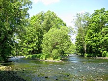
Thaya near Hardegg

Thaya and Umlaufberg


Practical advice
The state border runs in the middle of the river Thaya, the hiking trails are partly cross-border. Therefore, please bring your passport or identity card with you when visiting the national park!
