
| Opatówko | |
 St. Catherine of Alexandria St. Catherine of Alexandria | |
| Map | |
 | |
| Information | |
| Country | Poland |
| Region | Greater Poland Voivodeship |
| Area code | 48 (61) |
| Postal Code | 62-330 (post: Nekla) |
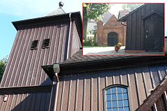
Opatówko - village in Poland, located in Greater Poland Voivodeship, in Września poviat, in the commune of Nekla; 6 km west of September. Known for the historic wooden church of St. Catherine of Alexandria from the mid-18th century.
Information
History
In the 11th century, Opatówko belonged to the Adwaniec family. In 1070, they donated them to the monastery in Lubiń. 250 years later, the Gniezno chapter changed Wyszaków from Zaniemyśl to Opatówko, which was still a hereditary property of the cleric Absalon, son of Bernard from Polwica. The diocese of Poznań included Opatówko in 1364, and in that year there was also a church in the village. In 1752 the archdeacon of Gniezno - Leon Morawski - founded the wooden church of St. Catherine.
In the 1880s, the village was inhabited by 114 people, all of Catholic faith, in 12 houses. In 1882 the landowner, Józef Wolski, sold it into German hands. At that time, there was also a brickyard and a peat mine in the village. In addition, there is also a manor and farm buildings from the turn of the 19th and 20th centuries. In the years 1975-1998, the town was administratively part of the Poznań Province.
Geography
Opatówko is located on the Września Plain (315.56), a physico-geographic mesoregion in the central-west Poland, constituting the southern part of the Greater Poland Lake District. The Olęderski Settlement Trail in the Nekla Commune runs through the village.
Climate
The region is influenced by the oceanic air masses, which contributes to the mild climate. The area is located in the agri-climate district of Wielkopolska and Silesia. The average annual temperature is around 8 ° C. The growing season is one of the longest in Poland. Annual rainfall ranges from 500 to 550 mm. The town can be visited at any time of the year.
Drive
By plane
The nearest airport is in Poznań - 49 km from Opatówek. It is Poznań-Ławica airport. Henryk Wieniawski (IATA: POZ, ICAO: EPPO) [1]. The best access from the airport via the S11 expressway - from the Poznań Ławica junction to the Poznań West junction, then via the national road number 92 towards Września. On the road along Zasutów, take the exit towards Podstolice.
By train
The nearest railway station is in Sub-capitals, from there about 1.7 km south to Opatówek
By car
National road 92 to Podstolice, from here it is 1.6 km to Opatówek - from road 92, along Sosnowa Street, then Kasztanowa Street, from here to the east along Jeżynowa Street straight to Opatówek
Worth seeing
In the village there is a historic wooden church of St. Catherine of Alexandria. It has very interesting equipment. A 16th-century crucifix is placed on the rood beam. The main altar is composed of rococo elements with a painting of St. Catherine from the 18th century. The plychrome sculpture of the Mother of God with the Child is also interesting. In addition, there is a manor complex: a manor house from the turn of the 19th and 20th centuries, completely rebuilt at the turn of the 70s and 80s of the 20th century, a stable, a barn, a pigsty and a cowshed from the 4th quarter of the 19th century, and the remains of a manor park. House no. 2 in the village dates back to the 4th quarter of the 19th century and is also protected, despite its partial reconstruction.
Education
The nearest educational institution is Zespół Szkół im. John Paul II in Zasutów [2]
Shopping
In the village there is a grocery store of the "Sklep Polski" chain
Boarding
The nearest catering center is in Sub-capitals - it is a restaurant "Polonia - Podstolice"
Entertainment
- Nearby is the Motocross Track - "MAGIERA" Opatówko / Nekla [3]
Accommodation
The "Pod Brzózkami" agritourism farm offers accommodation for rent. [4]
Security
Health
The nearest hospital is the County Hospital in Września, ul. Słowackiego 2, tel. 61 437-05-00 [5]. The nearest clinic is in Nekli
Police
The nearest police unit is the Poviat Police Headquarters in Września, ul. Szkolna 23, phone no. 61 437-52-00, emergency number 997 and 112 [6].
fire brigade
The nearest fire brigade unit is the County Headquarters of the State Fire Service in Września, ul. Wrocławska 44, tel. 61 222-07-70, emergency number 998 and 112 [7] (there is no voluntary fire brigade in the town).
contact
There is no tourist information point in the Nekla commune. Matters of promotion are managed by the Department of Promotion and Culture of the Poviat Staroste in Września, ul. Chopin 10, room. 110, phone: 61 640-44-95.
Where next
In the vicinity of Opatówek, there are the following towns, which can be another destination:
- September - a district town known for the strike of Września children - a strike of students in 1901-1902, directed against the Germanization of schools, mainly against prayer and teaching religion in German; seat of the regional museum,
- Sub-capitals - a town known for its neoclassical mansion from the 19th century,
- Nekla - a city known for its Dutch settlement from the mid-18th century,
- Nekielka - a town known for its Olęder settlement from the mid-18th century,
- Targowa Górka - a place associated with Antoni Amilkar Kosiński - a general, participant in the Kościuszko Uprising and Napoleonic Wars, co-founder of the Polish Legions in Italy, who died and rests in this town,
- Biechowo - a place known for the historic monastery complex of the Philippines (now Pauline Fathers) with the Church of the Nativity of the Blessed Virgin Mary - Sanctuary of Our Lady of Consolation.
Sources
The website uses content from the Opatówko website in Polish Wikipedia. Its authors are listed in editing history. Copyright: under license Creative Commons CC-BY-SA.
| This article already has the minimum information to make it useful . However, there is still a long way to go to become a guide. You can help by filling in the gaps and expanding the sections that have already started. |