
The Orla Perć (German Eagle path) is marked in red ![]() Höhenweg in the High Tatras in Poland. It is considered to be the most difficult hiking trail in the Tatras and all of Poland. At the same time, it is the longest ridge trail in the High Tatras. Its length is 4.5 km and it usually takes six to eight hours to complete the route.
Höhenweg in the High Tatras in Poland. It is considered to be the most difficult hiking trail in the Tatras and all of Poland. At the same time, it is the longest ridge trail in the High Tatras. Its length is 4.5 km and it usually takes six to eight hours to complete the route.
background

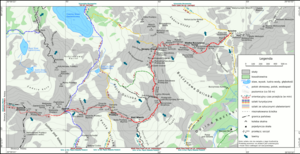
The idea of building a path here dates back to 1901. The path was built by the Polish Tatra Society between 1903 and 1906; the accesses were built between 1904 and 1991. The approach from Zmarzły Staw Gąsienicowy was opened in 1912, closed in 1925 and reopened in 1953. Since July 2007, the ascent of Orla Perć on the section from Zawrat saddle to Kozi Wierch has only been possible in one direction, with a short section that can be climbed in both directions.
getting there
By train
You can arrive by train Krakow. The terminus is Zakopane. From there you have to walk to the Murawaniec hut or Five Polish Lakes Hut to run.
In the street
Arrivals by road will also usually come from Krakow and end in Zakopane. You can get to Kuznice or Lysa Polana by car. From there we continue on foot.
Stages
The southernmost stage is currently closed because it is now in a strictly protected natural reserve. Otherwise you can always get on or off the valleys:
- from Kasprowy Wierch and Świnica
- from the Dolina Gąsienicowa valley from the Murowaniec hut on six different routes
- from the Dolina Pięciu Stawów Polskich valley from the Five Polish Lakes Hut on four different routes
See also
- Sokola Perć (Falcon path)