Preikestolen is located in Norway.
| ATTENTION: Some of the contents shown could generate dangerous situations or damage. The information is for illustrative purposes only, not exhortative or didactic. Use of Wikivoyage is at your own risk: read the warnings. | |
To know

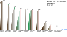
It is a 604 meters high granite cliff that ends overhanging the Lysefjord, in front of Kjeragbolten, near the village of Forsand.
Geographical notes
The city of Stavanger, the regional capital, is only 25 km from the site.
When to go
The excursion is not recommended in winter and in the early spring months when there is still snow and ice on the ground, and the path could be slippery. The best time to visit the "Preikestolen" is from April to October. However, the weather in summer can also be wet and cold, and clouds can cover the Preikestolen.
Background
"Pulpit Rock" was formed about 10,000 years ago, at the end of the Ice Age.
Territories and tourist destinations
The number of tourists in 2012 was 200,000. The Preikestolen is today one of the most popular sites in the Scandinavian country.

How to get

The car park can be reached in about an hour from Stavanger by ferry or car. The road to reach the site ends in the parking lot at the "Preikestolen fjellstue". A path extends from the parking lot to the rock, passing through a series of mountain landscapes. A hike on the Preikestolen from the nearest car park takes 3-4 hours round trip. In some places the climb can be very steep. The trail starts at the "Preikestolen fjellstue" at a height of about 270 m a.s.l., to reach the peak of 604 m. The excursion can last from 1 to 3 hours depending on the experience and fitness. The height differential is not high - only 334 meters - and the route is not very long (3.8 km).
Furthermore, if you do not want to climb the cliff, it is possible to take a ferry trip across the entire Lysefjord all year round, stopping under the Preikestolen. The ferry takes you to the bottom of the fjord (Lysebotn).
By car
Access to Preikestolen from Stavanger is via the RV13 road and the ferry from Tau. From the south, access is from the RV13 through Sandnes, via the ferry from Lauvik to Oanes.
A convenient alternative is available from mid-June to mid-August, a tourist ferry from Lauvvik to Lysebotn, passes under the Pulpit Rock. It is advisable to book well in advance, as this is a very popular route.
How to get around
What see
 1 Rock pulpit.
What to do
Shopping
Where to eat
Where stay
Safety

The Norwegian authorities have decided not to install barriers or use any other security measures to avoid damaging the beauty of the site. Furthermore, fatal accidents are extremely rare, despite the many annual visitors. Furthermore, such safety measures could paradoxically encourage dangerous behavior by some visitors, such as climbing fences. A common policy on the part of the Norwegian authorities is to consider that "we cannot close the whole nature of the country". There were no accidental victims on the site until 2013. However, there have previously been suicides and suicide attempts.
How to keep in touch
Around
Other projects
 Wikipedia contains an entry concerning Preikestolen
 Commons contains images or other files on Preikestolen

