 "Blue Grotto" at Qrendi | ||
| Qrendi / Il-Qrendi | ||
| District | South Eastern District | |
|---|---|---|
| Residents | 2.752 (2014) | |
| height | 117 m | |
| no tourist info on Wikidata: | ||
| location | ||
| ||

Qrendi is a village on the south coast of Malta in the South Eastern District.
background
The region on the south coast of Malta was already populated in prehistoric times, the Temples of Mnajdra and Ħaġar Qim are in the municipality.
As a village, Qrendi was first listed on a list of conscripts in 1417, at first it belonged to Żurrieq. In 1618 Qrendi became its own parish, the parish church was built in 1720.
During the time under the Order of St. John, several grand masters had their summer residences in Qrendi. During the Second World War, under British rule, a makeshift airfield was built in preparation for the Allied landing in Sicily, whereupon the village was promptly the target of bombing raids, which also destroyed the parish church.
With the Saint Mary’s Band and the Lourdes Band, the parish has two "band clubs", which prepare the big festivities in honor of the local patron, accompany the processions with music and organize fireworks. In the post-war years, the fireworks factories of Saint Mary’s and Lourdes Fireworks Factory suffered serious explosions with fatalities.
getting there
By plane
The 1 Malta International Airport located in Luqa a good four kilometers north of the community.
By bus
With Valletta resp. the central bus station in Floriana is Qrendi with the line 72 the bus company Arriva connected, the bus runs twice an hour from 6 a.m. to 10 p.m.
The bus route 71 runs from the bus station at the gates of Valletta west about Żurrieq to the "Blue Grotto" and the megalithic temples of Mnajdra and Ħaġar Qim on the south coast. The line 201 runs between the airport Luqa (Here you can change from the express lines) along the mentioned sights as a peripheral line further over Siggiewi and the Dingli Cliffs Rabat and Mdina.
In the street
One possibility of access from the greater area Valletta is the one across the main street 1 past Luqa International Airport, and then on the south coast road 117 above Żurrieq.
By boat
There are excursion boats on the south coast to the sight of the "Blue Grotto", but no regular passenger shipping line.
mobility

The easiest way to get around locally is with your own motor vehicle, due to the distance between the place and the temple complexes.
Tourist Attractions
Qrendi


There are a number of places of worship and residences in the local area:
- 1 St Mary's Parish Church: after Qrendi had been raised to an independent parish in 1618, it was decided to build a parish church on the highest elevation of the place in the area of two older chapels: St Mary's Church, built in 1655, soon no longer met the requirements and 1685/1712 became one larger parish church built according to plans by Lorenzo Gafà. It was only consecrated by Bishop Labini in 1782. In the church there are numerous paintings by famous artists, the wooden statue of the Assumption was created in 1840 by the Maltese artist Antonio Chircop.
- the 2 St. Catherine’s Chapel was built in the area of a previous building from 1575 in the same place in the area of "Tat-Torba" in 1625, a fief secured the financing. The little church was renovated in 2001 and the patroness of the church is celebrated on November 25th.
- the 3 St. Matthew’s Chapel consists of two assembled chapels, the older one on the precipice to the break-in of Il-Madluba dates from the 15th century. and be the oldest church building in Malta, the newer larger one was built in 1674/82. The altarpiece from 1688 is by Mattia Preti and shows the martyrdom of Matthew, it was not returned to its original location after being robbed. The church was opened in World War II on Sunday April 12, 1942, the facade and the roof had partially collapsed and numerous soldiers were injured, and the chapel had been converted to accommodate the troops. After the chapel has been rebuilt, the festival of St.Matthew is organized alternately by the two "Band Clubs" on the Sunday after September 21st.
- the 4 St. Anne’s Chapel was built by Giovanni Schembri to fulfill a vow after the Turkish siege of 1565 and restored in 1796 and in recent years.
- the chapel 5 Our Lady of Mercy, Madonna Tal-Hniena was built in the medieval hamlet of Hal-Lew, when Qrendi was still part of the Żurrieq parish. A first building from the 13th century. was replaced by the larger building in 1650 and the sacristy added in 1668, in the church there are numerous paintings and ex-voto gifts.
- in the south of the village on the way to the Guarena Palace is the chapel 6 Our Lady of Graces from 1658, it was built by Angelo Spiteri.
- the chapel 7 Our Lord Savior, Is-Salvatur was built by Benedittu Camilleri in 1658 to replace an older chapel and rebuilt in 1876. During the Second World War, the chapel served as accommodation for bombed out and later as a classroom; it was renovated in 1996.
- at the Triq it-Torri there is the octagonal one 8 Cavalier Tower, Torri iġ-Ġwarena, the tower with extraordinary architecture was built in 1659 under Grand Master de Rodin.
- the fortress-like one 9 Guarena Palace was built in 1735/40 under Pier Francesco Guarena di Rovero as a private residence and served as accommodation for an infantry battalion of the King’s Own Malta Regiment during World War II.
- the 10 Guttenberg Palace, which adjoins the "Oue Lady of Mercy" chapel in the hamlet of Hal-Lew, is also a real square residential tower, which was built in the 17th century. was built by Johann Wolfgang von Guttenberg and was used by him when he was not at sea.
- the 11 Il-Maqluba Valley: after a huge storm a huge karst funnel opened up in 1343, the 100 m diameter hole with a depth of 45 m is barely reached by daylight at the bottom and resembles a meteorite crater with green vegetation. In winter, the water from the surrounding area converges in this depression and probably flows underground towards the sea. To the bottom of the valley, in the Malta's national tree Għargħar (Sandarac Gum Tree / Callitris articulata) grows, can be descended.
- the 12 Hamrija Tower in the Ħamrija valley lies south of the megalithic sites and was in the 17th century. Built under Grand Master De Redin as part of a warning network, the watchtowers triggered an alarm when enemy ships were approaching. Nearby is that Congreve Monument in memory of the British Governor Congreve, who was buried between the coast and the island of Filfa after his death.
- the 13 Ta 'Sciutu Tower was built as an observation tower under Grand Master Lascaris and today serves as the police station of Wied iż-Żurrieq, a hamlet on the south coast near the "Blue Grotto".
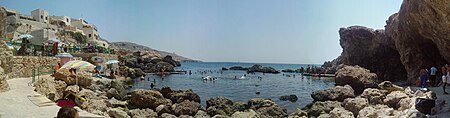
Blue Grotto


- At a fjord-like incision Tat il Hnejja west of Wied iż-Żurrieq is the sea access to the caves 14 "Blue Grotto"to which visitors are taken by boat (attempting to swim can be very dangerous due to strong currents and waves!). Blue algae make the water appear bright blue in the morning, with red algae flashing in between. The region is also a popular destination of Scuba divers, like the wreck of the Libyan ship Um El-Faroud off the coast.
- Blue Grotto boat service (with bus line 201 always, bus line 71 from Valletta in summer). Tel.: 356 21640058. The boats only operate in good weather conditions.Open: summer time 9:00 a.m. - 5:00 p.m., winter time 9:00 a.m. - 3:30 p.m.Price: adults € 8, children € 4.
One can walk to the temple complex of Ħaġar Qim. The distance is less than 2 km and there is a wide sidewalk next to the connecting road. This is usually faster than waiting for the next bus.
Filfla Island

The 6 hectare 15 Pepper Island, Filfla Island![]()
![]()
![]() lies within sight of the coast, on it there are traces of human settlement from the Neolithic Age and ruins of a chapel from the 14th century, in which food was available for fishermen in distress at sea. After the islet had served as a target for bombing between 1945/70, it was declared a nature reserve in 1988: rare birds and lizard species (the endemic Maltese wall lizard) have found a habitat there. Although the area around the island would be interesting as a diving spot, every one is Entering the island is strictly prohibited resp. only possible with a hardly available special permit from the Ministry of the Environment.
lies within sight of the coast, on it there are traces of human settlement from the Neolithic Age and ruins of a chapel from the 14th century, in which food was available for fishermen in distress at sea. After the islet had served as a target for bombing between 1945/70, it was declared a nature reserve in 1988: rare birds and lizard species (the endemic Maltese wall lizard) have found a habitat there. Although the area around the island would be interesting as a diving spot, every one is Entering the island is strictly prohibited resp. only possible with a hardly available special permit from the Ministry of the Environment.

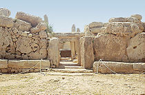
Ħaġar Qim


The temple complex of 16 Ħaġar Qim is south of Qrendi above the cliffs of Malta's south coast.
The facility, which has been known for centuries, was first built in 1839 by T.G. Vance of the "Royal Engineers" examined and brought a found altar and Magna Mater statues to Valletta. In 1885 the excavations were carried out by Dr. A. A. Caruana and carried out further excavations in 1909 by Sir Th. Zammit, a careful investigation finally brought to light the "Venus of Ħaġar Qim" in 1950, along with fragments of other Magna Mater statues. Since the plant made of globigerine limestone shows clear signs of erosion due to the weather, it was roofed over with a protective tent in 2009.
In contrast to other temple complexes, the complex is surrounded by a high wall of megaliths and is entered through a trilith gate from the southeast. Originally the temple had probably consisted of a forecourt and a temple room, each with two side apses, and was then redesigned. In the right side apse, offerings could probably be "submitted" through a hole and collected behind a low wall. The original altar found in the forecourt area on the left can be viewed in the National Archaeological Museum, as can the Magna-Mater - figures with the so-called "Venus of Ħaġar Qim" found in the main chamber.
The side chambers with separate entrances from the south, west and north were probably added in a next construction phase.
- Ħaġar Qim Temples, Triq Ħaġar Qim, Qrendi QRD 2501. Tel.: 356 21 424 231. Open: Oct-March 9 am-5pm, April-Sept. 09.00-19.00.Price: 9.00 / 6.50 / 4.50 € (together with Mnajdra).
Mnajdra


.jpg/210px-Mnajdra_Temple_2_(6799945248).jpg)

The temple complex of 17 Mnajdra is also located on the high plateau above Malta's south coast and is only 500 m away from the temple complex of ġaġar Qim.
A year after the discovery of the temple complex of Ħaġar Qim, the temples of Mnajdra were opened by J.G. Vance discovered in 1840. In 1901 Albert Mayr improved plans from 1879; It was not until 1910 that Thomas Ashby expanded the excavations, which were largely completed in 1949 with further finds. After storm damage in 1994, the facility was restored and, like the other nearby facility, was covered with a protective roof.
The East Temple As the oldest building, it has been largely reconstructed, the entrance megaliths and the floor are original. The temple consists essentially of a temple room with a niche.
The South temple was aligned to the sun position. At the equinox, the sunlight falls through the entrance exactly on the altar, in the winter and summer solstice over the edge of the megaliths to the right and left of the entrance onto the left and right side stone (with decorations from drill holes) in the side apse.
The Central Temple was later built between the other two temples. It is characterized by relatively large apses and well-preserved passages (triliths and door stones with a through hole).

They can be found about 200 m to the north 18 Misqa tanks, prehistoric cistern / water pit systems, which were used to store rainwater already in the time of the temple cultures and which still collect rainwater today.
activities
- Visiting the sights in and around the city
- Attendance of the festivities at the end of July / beginning of July of the Soċjeta ’Mużikali Lourdes and on August 15th / Assumption of the Virgin Soċjeta ’Mużikali Santa Marija organized: both club bands organize a typical Maltese festival with processions through the decorated city, music lectures and of course fireworks.
- Boat trip to the "Blue Grotto", bathing trip to the rocky beach of 1 Għar Lapsi to the romantic sunset known in Malta.
- for those interested in archeology, visit the temples of Ħaġar Qim and Mnajdra, both of which are adjacent on the south coast.
shop
kitchen
There are restaurants in town and also in Wied iż-Żurrieq (above the "Blue Grotto") and near Ghar Lapsi.
nightlife
accommodation
security
health
Practical advice
trips
- depending on your interests to the "Dingli Cliffs" (natural beauties) or the temples of Tarxien.