The Tizi-n-Test cycle route leads from Marrakech via the Tizi-n-Test pass (2029 m) Taroudant.

background
The Tizi-n-Test connects Marrakech with the fertile Souss Valley in the south. He shows two faces. To the north the landscape slowly slopes down to Taroudant. 1600 meters difference in altitude, spread over 130 km. The route follows the valleys of the Oued Rheraya and Oued Nfiss up and only in the last section does it curve up to the summit structure, which drops steeply to the south. Only 30 km after the pass you are already 1600 m lower. Steep serpentines and long inclines dominate.
Travel time
In principle, traveling in Morocco is possible all year round. The spring months between January and March are a very popular travel time due to the start of the flowering period. In summer it can get very hot in the southern interior. Then it is advisable to stay in the cooler coastal region. In winter it can get very cold in the mountains.
The passes of the High Atlas are impassable in winter. They can be closed until March / April due to snow and snowmelt. Autumn is preferred, with stable weather and pleasant temperatures.
| Marrakech | Jan | Feb | March | Apr | May | Jun | Jul | Aug | Sep | Oct | Nov | Dec | ||
|---|---|---|---|---|---|---|---|---|---|---|---|---|---|---|
| Mean highest air temperature in ° C | 18.2 | 19.8 | 22.1 | 23.5 | 27 | 30.6 | 35.6 | 35.3 | 31.8 | 27 | 22 | 18.6 | O | 26 |
| Mean lowest air temperature in ° C | 5.6 | 7.3 | 9.1 | 10.8 | 13.6 | 16.3 | 19.8 | 19.9 | 18 | 14.3 | 10.1 | 6.3 | O | 12.6 |
| Precipitation in mm | 32.4 | 35.1 | 30.4 | 28.6 | 14.2 | 4 | 1.1 | 2.5 | 6.1 | 22.2 | 38.3 | 35.4 | Σ | 250.3 |
| Marrakech | Jan | Feb | March | Apr | May | Jun | Jul | Aug | Sep | Oct | Nov | Dec | ||
|---|---|---|---|---|---|---|---|---|---|---|---|---|---|---|
| Mean highest air temperature in ° C | 16 | 16 | 18 | 19 | 22 | 25 | 28 | 29 | 27 | 24 | 20 | 19 | O | 21.9 |
| Mean lowest air temperature in ° C | 9 | 8 | 10 | 11 | 13 | 15 | 18 | 19 | 18 | 16 | 12 | 10 | O | 13.3 |
| Precipitation in mm | 37 | 33 | 29 | 18 | 4 | 1 | 0 | 0 | 7 | 19 | 33 | 45 | Σ | 226 |
preparation
By bicycle
The route is paved throughout with gradients of up to 10%. A touring bike with gear ratios below 1.0 is recommended, especially if you want to ride the route from the south.
getting there
by plane
The airport 1 Marrakech Menara![]()
![]()
![]() (IATA: RAK) is about 5 km southwest of the city center. The can be reached in less than half an hour by bike 1 Djemaa el Fna in the heart of the old town. Directly from the airport car park, follow the for almost 3 km Ave Guemassa on the bike lane to the east, then north-northwest the Blvd el Yarmouk along. After 800 m you will reach the Place Bab Jdid with the city gate Bab Jdid Through the gate to the east of the Ave Houman el Fetouaki following into the pedestrian zone. The one that is already visible from afar serves as a guide 2 Koutoubia mosque.
(IATA: RAK) is about 5 km southwest of the city center. The can be reached in less than half an hour by bike 1 Djemaa el Fna in the heart of the old town. Directly from the airport car park, follow the for almost 3 km Ave Guemassa on the bike lane to the east, then north-northwest the Blvd el Yarmouk along. After 800 m you will reach the Place Bab Jdid with the city gate Bab Jdid Through the gate to the east of the Ave Houman el Fetouaki following into the pedestrian zone. The one that is already visible from afar serves as a guide 2 Koutoubia mosque.

with the train
Marrakech is the southern end of the rail network in Morocco. There are direct train connections to Fes and to the train station Casa Voyageurs in Casablanca, from where you can continue to the north after Tangier comes.
The trains end in the newly built in 2008
from Marrakech.
Marrakech
- 3 Menara Gardens, Ave de la Ménara.


 in the Wikidata database")

- 1 youth hostel, Rue el Jahed, Quartier Hivernage II (Close to the French consulate).
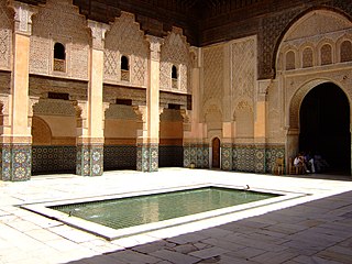
- 5 Medersa Ben Youssef, Place Ben Youssef.
- 1 Café des Epices, Place Rahba Qedima.
- 1 Artisanal ensemble, Ave Mohammed V.


route
from Marrakech to Asni (50 km)
The city exit from the center of 1 Marrakech![]()
![]()
![]()
![]() (Arabic:مراكش) (466 m) is relatively short. The traffic is chaotic and confusing at first.
(Arabic:مراكش) (466 m) is relatively short. The traffic is chaotic and confusing at first.

From the central Ave Mohammed V one arrives at Place de la Liberte on the Blvd el Yarmouk to the city gate Bab Jdid. Further southeast, at the end of the Mohammed V Blvd in the Koutoubia mosque it can be reached via the Ave Houman el Fetouaki. From the city gate further south of the Blvd el Yarmouk follow up to the roundabout where you get the R 203 finds. Follow it to the southwest out of the city. After 5 km, at the roundabout bends the R 203 to the south. 26 km further on one reaches 2 Tahanaout(31 ° 22 ′ 2 ″ N.7 ° 56 ′ 39 ″ W.) (Arabic:تحناوت, Also Tahanaoute) (919 m).
Tahanaoute
The city with 6500 inhabitants is located at the foot of the High Atlas. In Tahanaoute, the P2010 turns into Ourika valley leads.
- 1 post
- 2 Souk
- 3 Hotel Nzaha
- 2 Enzaha restaurant.
4 km after Tahanaoute you reach a 3 Junction. If you follow the road for one kilometer you will find it 4 Atlas Mountain Hotel Kasbah AngourAfter another 12 km you will reach the 4 Turn off to Moulay Ibrahim (1137 m).
Moulay Brahim
The mountain village 3 Moulay Brahim![]()
![]()
![]() , at 1350 m, with 3000 inhabitants, is 4 km along the road above the course of the river Oued Rheraya on the Kik plateau.
, at 1350 m, with 3000 inhabitants, is 4 km along the road above the course of the river Oued Rheraya on the Kik plateau.
- 5 Grande Taxi Station
- 6 Masjid Mouley Brahim
A few hundred meters after the intersection, you will pass the building on the right 2 Gendarmerie Royale and one km later you reach Asni.
Asni
4 Asni![]()
![]()
![]()
![]() (Arabic:أسني) (1185 m), with about 3000 inhabitants is on Oued Rheraya at 1150 m Asni is actually more of a community of small villages scattered across the valley. The houses are adjacent to the cultivated fields. In Asni, the P2015 turns south. After 15 km you reach the mountain village Imlil, Starting point for tours on the Jbel Toubkal. With 4167 m the highest mountain in North Africa, lined up along the main road 6 Afriquia gas station, Shops and restaurants.
(Arabic:أسني) (1185 m), with about 3000 inhabitants is on Oued Rheraya at 1150 m Asni is actually more of a community of small villages scattered across the valley. The houses are adjacent to the cultivated fields. In Asni, the P2015 turns south. After 15 km you reach the mountain village Imlil, Starting point for tours on the Jbel Toubkal. With 4167 m the highest mountain in North Africa, lined up along the main road 6 Afriquia gas station, Shops and restaurants.
.jpg/320px-Centre_de_santé_d'Asni_(Maroc).jpg)
- 5 Auberge Jeunesse d'Asni
- 7 Tatfi de l'Atlas
- 8 Riad Asselda (after the market turn left, cross the Oued Rheraya, then left again and follow the road).
- 9 Hotel Valle Verte Asni
from Asni to Talat N'Yaacoub (50 km)

Asni Leaving it, it goes uphill briefly to a small plateau with a beautiful view back to the valley. Then you roll downhill in a narrow valley and follow it for 15 km Asni one reaches Ouirgane.
Ouirgane
In the Berber village 5 Ouirgane![]()
![]() (31 ° 10 ′ 32 ″ N.8 ° 4 ′ 40 ″ W.) (906 m) with 1500 inhabitants one reaches the Oued Nfiss the through the Barrage of Yaacoub el Mansour to the Lalla Takerskout Since the dam, the place, which lies in a picturesque landscape with pine forests next to red clay, has been a popular tourist destination. Swimming, water-skiing and kayaking are possible on the lake.
(31 ° 10 ′ 32 ″ N.8 ° 4 ′ 40 ″ W.) (906 m) with 1500 inhabitants one reaches the Oued Nfiss the through the Barrage of Yaacoub el Mansour to the Lalla Takerskout Since the dam, the place, which lies in a picturesque landscape with pine forests next to red clay, has been a popular tourist destination. Swimming, water-skiing and kayaking are possible on the lake.

From Ouirgane follow it Oued Nfiss through a beautiful valley landscape up to Ijoukak. You pass the small villages6 Amesguen (Arabic:أمـسكـن),7 Imgdal (Arabic:إيميدال)(3 Shop),8 Tigouramine (Arabic:تـيـكورامين)9 Toug El Khair (Arabic:طوق الخيرWhere the valley is, 32 km after Ouirgane, one reaches to a level widening Ijoukak.
Ijoukak
The Berber village 10 Ijoukak ![]()
![]() (30 ° 59 '34 "N.8 ° 9 ′ 11 ″ W.) (Arabic:اجوكاك) (1180 m) with 1500 inhabitants is 500 m south of the R203. It is the last larger place before the pass of the Tizi-n-Test and so there are many simple restaurants and cafes here.
(30 ° 59 '34 "N.8 ° 9 ′ 11 ″ W.) (Arabic:اجوكاك) (1180 m) with 1500 inhabitants is 500 m south of the R203. It is the last larger place before the pass of the Tizi-n-Test and so there are many simple restaurants and cafes here.
- 13 Gite Assalam
About 3 km further on the R203 following one reaches Talat N'Yaacoub.
Talat N'Yaacoub
11 Talat N'Yaacoub![]()
![]()
![]() (30 ° 59 ′ 37 ″ N.8 ° 10 ′ 58 ″ W.) (Arabic:ثلاثاء نيعقوب) (1207 m) is a community consisting of several villages with about 8000 inhabitants.
(30 ° 59 ′ 37 ″ N.8 ° 10 ′ 58 ″ W.) (Arabic:ثلاثاء نيعقوب) (1207 m) is a community consisting of several villages with about 8000 inhabitants.

- 3 post
- 7 taxi
- 4 Souk
- 3 Al Mouahidine restaurant
from Talat N'Yaacoub to the Tizi-n-Test (37 km)


If you follow the R203 about 5 km from Yaacoub you will reach the 8 Junction to Tin Mal.
Tin times
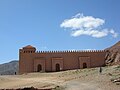
The small mountain village 12 Tin times (Arabic:تينمل, Also Tinmel) lies at about 1270 m. It is a point of origin of Moroccan history, the cradle of the Almohad empire and at the same time the last testimony to the conquest of the Almohads in the 12th century. The holy city of Tinmal was founded by Ibn Toumart, who started from here the holy war against the Almoravids began. In 1276 the city, the last place of refuge when the Merinids set out to conquer Morocco, was largely destroyed 8 Tin Mal Mosque![]()
![]()
![]() (Arabic:تينمل) Was restored in 1990 and included in the tentative list of World Heritage Sites UNESCO recorded[1]This mosque is architecturally the original type of the classic Almohad mosque, also the model of the Koutoubia mosque, which was later built in Marrakech [2].
(Arabic:تينمل) Was restored in 1990 and included in the tentative list of World Heritage Sites UNESCO recorded[1]This mosque is architecturally the original type of the classic Almohad mosque, also the model of the Koutoubia mosque, which was later built in Marrakech [2].
.jpg/210px-Tin_Mal_Mosque1_(js).jpg)
.jpg/120px-Tin_Mal_Mosque7_(js).jpg)

- 4 Café Restaurant Ba Adam Tinmel
The R203 now rises steadily to the narrow Oued Nfiss Following the valley. It happens16 Hotel Dar Elmouhaidi (Arabic:دار الموحدين) And the small villages13 Ifourirene (1270 m) and14 Tassouakts (1288 m). 10 km after Tin times leaves the road Oued Nfiss and rises in bends. After the first bends, that's it 5 Café Restaurant Gundafa (1397 m). This follows 5 km further 6 Café Igdelt (1556 m). After another 4 km you will find the steepest section on this side of the pass: wide serpentines with a magnificent view of the valley, which quickly lies deeper and deeper below you, you reach the last 4 km later 9 Sweep (1866 m). It's flatter to the southwest to one 9 saddle (2019 m). 6 km after the saddle, 37 km after Yaacoub, you reach the top of the pass.
Tizi-n test
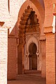
At the pass of the 10 Tizi-n test![]()
![]()
![]() (2092 m) there is a small one 7 restaurant. Overnight stay possible on request 11 summit (2510 m) can be reached via a poor footpath from the pass to the north, then stopping to the east, which is reached a bend below17 Hotel Gite Bellevue (2022 m) with a magnificent view to the south to the Anti Atlas.
(2092 m) there is a small one 7 restaurant. Overnight stay possible on request 11 summit (2510 m) can be reached via a poor footpath from the pass to the north, then stopping to the east, which is reached a bend below17 Hotel Gite Bellevue (2022 m) with a magnificent view to the south to the Anti Atlas.
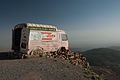
.jpg/350px-High_Atlas15(js).jpg)

View along the R 203 from the Bellevue restaurant
Souvenir shop at the Bellevue restaurant


from Tizi-n-Test to Taroudant (90 km)

A spectacularly steep descent follows from the top of the pass. In a little more than 30 km it goes 1600 m down to the N10. The road was partially carved out of the rock, in places there is no space for oncoming traffic. The hairpin bends are covered with gravel and there are usually no guard rails to protect against the precipice.
This is reached after 11 km 8 Café Imdress At 1594 m, 4 km later you pass a few houses on a bend 10 parking spot at an altitude of 1396 m, some after 500 m 15 Houses with a shop (1384 m). 13 km later you meet the 11 Junction to Tafingoult (753 m). Now it runs R203 flatter until you reach the 8 km later 12 Taroudant-Taliouine crossing reached. Now you follow that N10 10 km after Ouled Berhil.
Ouled Berhil
16 Ouled Berhil(30 ° 38 '25 "N.8 ° 28 ′ 31 ″ W.) (Arabic:أولاد برحيل), 500 m above sea level, with its 24,000 inhabitants, is especially famous for its kasbah, which today is the 18 Riad Hida houses.
- 9 Tiznit restaurant
- 12 Petrom petrol station
- 10 Café Essalam
- 5 Western Union
- 6 Credit Agricole
- 13 Boulangerie Loubab
- 14 Shell petrol station
After 44 km to the west of the N10 one reaches Taroudant.
Taroudant
17 Taroudant![]()
![]()
![]()
![]() (Arabic:تارودانت) A 80149 The oasis town with its inhabitants is about 240 m above sea level. d. M. The city, with its mile-long six-meter high city wall, is also called the Pearl of the south designated. It lies in the fertile Souss plain, in which, among other things, argan trees are grown. A very high quality oil is obtained from the argan fruits.
(Arabic:تارودانت) A 80149 The oasis town with its inhabitants is about 240 m above sea level. d. M. The city, with its mile-long six-meter high city wall, is also called the Pearl of the south designated. It lies in the fertile Souss plain, in which, among other things, argan trees are grown. A very high quality oil is obtained from the argan fruits.
.svg/350px-Flag_of_France_(1794–1815,_1830–1958).svg.png)
- 13 Gare routiere
- 15 Grande Mosque
- 7 Bank BMCI
- 14 Afriquia gas station
- 4 Pharmacie Maadiat
- 5 Pharmacie Aït Iaaza
- 6 Clinique les Orangers, Boulevard Mokhtar Soussi.
security
visa
Please refer Morocco to the current information.
trips
The N 10 runs from Agadir, on the coast, up Bouafra, to the west on the border too Algeria and opens up the entire Souss-Massa-Draâ region.
- to the west one reaches Ait Melloul With Agadir and the west coast.
- to the east over Taliouine and Tazenakht one reaches Ouarzazate and the Draâ valley as well as the Street of the Kasbahs to Er-Rachidia.
- in the south it goes over the Souss plain in the Anti Atlas to Tafraoute
literature
travel Guide
- : Morocco. Victoria, Australia: Lonely Planet Publications, 2007 (8th edition), ISBN 978-1-74059-974-0 (closely).
Maps
- Michelin - Morocco (959). Scale: 1:800.000. Michelin Editions des Voyages.
Other books
- : Healthy Travel - Africa. Victoria, Australia: Lonely Planet Publications, 2000, ISBN 1-86450-050-6 (closely).
- : Orientation with map, compass, GPS: basic knowledge and procedure exercises. Herford: Busse and Seewald, 1998 (9th, revised and expanded), ISBN 3-512-03184-6 .
- : Faces of the Earth, World Vademecum, geographical handbook and reader for travel, school and geographic further education. Hanover: Tourist book, 1999 (3rd, completely reworked, updated and greatly expanded), ISBN 3-924415-23-4 .
Web links
- On the website of the Federal Ministry for Europe, Integration and Foreign Affairs information about Morocco
- The world's most spectacular roads: Tizi-n-Test In: www.dangerousroads.org
credentials
- ↑UNESCO (English) accessed on July 17, 2016
- ↑https://de.wikipedia.org/wiki/Moschee_von_Tinmal