| Cape Verde | |
 | |
| location | |
.svg/250px-Cape_Verde_(orthographic_projection).svg.png) | |
| Flag | |
 | |
| Main information | |
| Capital city | Praia |
| Political system | republic |
| Currency | Cape Verde Escudo |
| Surface | 4 033 |
| Population | 540 000 (2016) |
| Tongue | Portuguese, Creole |
| religion | Catholicism (77%) |
| Code | 238 |
| Internet domain | .cv |
| Time zone | UTC -1 |
| Time zone | UTC -1 |
Cape Verde - an island state in the Atlantic Ocean, located 450-620 km off the west coast Africa, geographically identical to the Cape Verde Islands, including territorial waters. It is a small but diverse archipelago of nine inhabited islands and several dozen smaller islets. The main advantages for tourists are the warm, subtropical climate, the landscape diversity of the islands, security and political stability, no need for vaccination, culture (hence the origins of, among others, Cesária Évora). As a result, they are a great alternative to more distant places. The most popular islands among tourists are by far Sal and Boavista, accounting for approximately 90% of the tourist traffic.
Characteristic
Geography
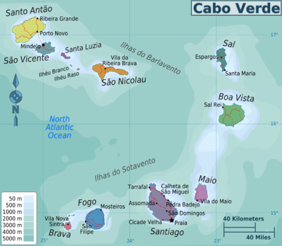
The country consists of nine inhabited islands and numerous smaller islets with no permanent population. Santa Luzia is considered the tenth island, but it is deserted and currently uninhabited. Traditionally, the archipelago is divided into the northern Lee Islands (Barlavento) and the southern Leeward Islands (Sotavento). Landscaped, the eastern islands of Sal, Boavista and Maio are relatively flat and semi-arid, while the western islands are mountainous. There is an active volcano on the island of Fogo (last eruption 2014). Cape Verde is part of the floristic province of Macaronesia (together with Azores, Canary Islands and Madeira). Some islands are surrounded by colorful and life-rich coral reefs. Due to its location on the islands, there is no large fauna typical of Africa. The only major cities are Mindelo (about 70 thousand inhabitants) and the capital Praia (about 130 thousand).
Population
Most of the inhabitants are Creoles - descendants of European settlers and slaves. Mulattoes dominate, while on Santiago a large part are blacks. On the island of Sal, immigrants from Senegalbesides, there are small groups of Chinese and Europeans. Most of the inhabitants (over 3/4) profess Catholicism, a visible Protestant minority (mainly from the Church of the Nazarene), and also non-religious and small groups of Mormons, Jehovah's witnesses, Sephardic Jews, Muslims and others.
Climate
The islands have a warm subtropical climate with average temperatures of 21-27 ° C, with a warmer period from June to October and little rainfall. A notorious problem is the lack of drinking water, most of which is obtained by desalinating sea water or by importing. Only the higher mountain areas of the western islands receive more rainfall.
History
The islands were perhaps already known in antiquity, as well as to Arab sailors, but their definitive discovery was made by the Genoese in the service of the Portuguese king António de Noli in 1456. Soon the islands became a Portuguese overseas territory and this state lasted until 1975. The islands were initially one of the main centers of the transatlantic slave trade, they then became an important supply point for steamers and whaling ships. Periods of relative prosperity were mixed with times of disasters and crises that forced them to emigrate to Portugal, its colonies and the United States. After independence, it was ruled authoritarian for 15 years by the Marxist PAICV party. In 1990, there was a peaceful transformation and transformation into a parliamentary republic. Since then, the country has gradually developed.
Policy
The state is a semi-presidential republic, next door Mauritius and Botswana meeting the highest standards of political culture in Africa. In the ranking Democracy Index created by the magazine The Economist took a high 23rd place in the world, between Italy and France. Power is alternately exercised by representatives of the two main parties: the left-wing PAICV and the center-right MpD. 26 Cape Verde 7.88 Democracy defective Republic
Economy
Cape Verde is a developing country with one of the higher living standards in Africa, comparable to the poorer countries of Europe; despite this, nearly 1/4 of the population lives in poverty. Currently (2017), he is in the forefront of Africa in many rankings, thanks to political stability, unique for this part of the world. Fish accounts for over half of the exports. Most of the country's GDP is generated by services, with an increasing share of tourism. A characteristic feature is the large share of money transfers from abroad, from the numerous Caboverdian emigration.
Drive
By car
An island state does not have any permanent car connections.
By plane
The island has four international airports on the islands of Sal, Boavista, Santiago and São Vicente. Most of the tourist traffic is served by the first two airports. From them it is easy to get to the accommodation by taxi, minibus (aluguer), or a rented car.
By ship
The islands do not have regular ferry connections, however, cruise ships regularly reach Mindelo on the island of São Vicente.
Visa
The visa can be obtained at the airport, at the consulate, or through a travel agency. It is usually a formality and it is not difficult for Europeans to get it. From 2018, the visa requirement for EU citizens for stays of less than 30 days is to be abolished.
Regions
Each of the nine inhabited islands has a different landscape, culture, dialect, and lifestyle. Traditionally, the islands are divided into Leeward (Santo Antão, São Vicente, São Nicolau, Sal and Boavista) and Leeward (Brava, Fogo, Santiago and Maio). The three eastern islands (Maio, Boavista and Sal) stand out by their nature and are flat and semi-arid, while the rest of the islands are dominated by mountain and upland landscapes. On the basis of tourist traffic, it is possible to distinguish touristic Sal and Boavista with well-developed hotel infrastructure and beautiful beaches, Santiago and São Vicente with larger cities and other islands with moderate or modest tourist traffic.
Boavista

The 620 km² island is inhabited by about 12 thousand people. inhabitants, it is also the closest to the African continent in the entire archipelago. The second most popular tourist destination in the country, hosting 31.6% of tourists in 2016. The largest town is with 6 thousand. the inhabitants of Sal Rei ("royal salt"). Despite the intensive development of tourism, it has retained a more "authentic" character than Sal, to which it is similar in landscape. In the center of the island there is the only sandy desert of the archipelago. Developed network of tourist services.
Brava

The smallest and most difficult to access inhabited island of the archipelago, area 67 km², less than 6,000 inhabitants. Most of the population comes from refugees fleeing the volcano Fogo eruptions. In the 19th century, an important whaling base attracted numerous ships. Visible historical American influence, for over a century the US consulate was located here. Due to the mountainous landscape and location away from the mainland, it has quite a diverse climate, with a short and warm rainy season from July to November. It is considered the greenest of the islands and is referred to as the "island of flowers". The capital is the small historic town of Nova Sintra.
The island can only be reached by ferry from Fogo and Santiago, therefore it is quite difficult to access and there are few tourists. The main occupation of the population is agriculture.
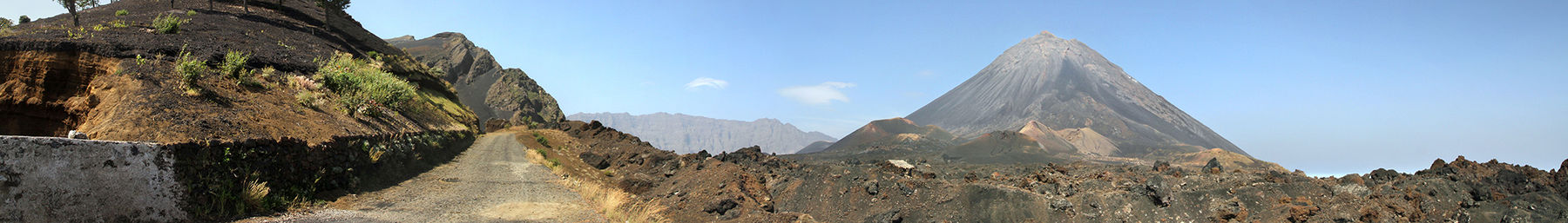
Fogo

The island is the cone of an active volcano, the highest peak in the country with the Pico de Fogo summit 2 829 m above sea level. It has 476 square kilometers and 37 thousand square meters. residents. The capital and largest city is São Filipe in the west of the island. It is also a good base to get to know her. Developed agriculture, coffee and fruit plantations, viticulture. Inhabitants known for their strict character, which is attributed to the constant sense of danger from the volcano. It can be visited during a day trip, and there are also designated tourist routes for longer exploration.
Maio

A small, lonely island east of Santiago, 269 km², 6.5 thousand. residents. It was discovered on May 1, 1460, hence the name. The landscape resembles Sal and Boavista, but unlike them it is sparsely populated, does not attract mass tourism and has kept its original atmosphere. Access to the island is possible by ferry or plane, but there are no daily connections. The main occupation of the inhabitants was salt mining, and nowadays fishing, agriculture and tourism. There is also a sizeable forest on the island that has been planted as part of a reforestation program as part of the efforts to prevent desertification. The biggest attraction is the long sandy beaches.
Sal
.jpg/220px-Sal_cape_verde_santa_maria_-_panoramio_-_brunobarbato_(11).jpg)
The second smallest of the inhabited islands (216 km²) is also the country's most popular tourist destination. The island is flat and semi-arid, with few individual hills and periodic streams. Sal enjoys 350 sunny days a year. The island is home to the republic's oldest and largest airport, named after Amílcar Cabral, located less than 2 km south of Espargos. A very well-developed network of accommodation. Most of the hotels and resorts are concentrated in the south of Santa Maria (6,000 inhabitants), however, accommodation is also available in other towns. The island is known for its beaches, including the most famous Ponta Preta.
Santiago

The 991 km² island is the largest and most populous island in the archipelago. It is considered the most "African" in character. The capital of the state is located here, with over 130 thousand. Praia residents. It is the most diverse island, divided into three distinct parts by the Antónia and Malagueta mountain ranges: the south with the capital and Cidade Velha, the central highland, famous for agriculture, around the town of Assomada and the northern one around Tarrafal with the beach popular with Prai people. The island can be easily reached by plane or ferry. Fairly well developed road network. The roads around the capital and the highway linking Praia with Assomada and Tarrafal are paved and paved.
The main attractions are:
- Historic town Cidade Velha inscribed on the UNESCO World Heritage List
- Historic center of Prai, museums
- Former Portuguese political prison in Tarrafal
- São Jorge dos Orgãos Botanical Garden
- Assomada market and regional museum
Santo Antão

The second largest island of the archipelago, covering 779 km² of land with a population of 47,000. It is mountainous with the highest peak, Topo de Coroa, reaching 1,979 m above sea level. Santo Antão is divided into two distinct parts: the rugged southern semi-arid city with the capital and largest city of Porto Novo, and the northern one with a more humid climate, with numerous plantations, historic villages, mountain forests and greenery. Part of the population is engaged in agriculture. The island attracts more and more hikers, there is a network of trails and various hiking opportunities. Caution: the most difficult trails should be taken with a guide!
Santo Antão can only be reached by ferry from Mindelo, there are several connections a day. The crossing time is between 30 and 60 minutes depending on the vessel. From Porto Novo you can easily find transport to your agreed accommodation. There is a fixed transport price list on the island - one for taxis, the other for minibuses (aluguer, collective taxi). Often, bus drivers first offer a private ride, if we want a collective ride, it should be made clear.
The most popular routes are:
- Paúl Valley (longer option from Cova de Paúl 5h) - descent to the town of Paúl over 1000m through a picturesque valley full of plantations and villages. Possibility to eat a meal on the way, buy local products.
- Descent through the Torre valley (longer option from Água das Caldeiras 5h) - descent to the town of Ribeira Grande over 1000m in a valley with plantations.
- North coast route from Chã de Igreja to Ponta do Sol (5h), along steep cliffs and through the picturesque village of Fontainhas. In the vicinity of Curzinha da Garça beach.
São Nicolau

With 388 km² and inhabited by 13.5 thousand. island inhabitants of a mountainous nature. In the 18th century, it served as the capital, sheltering against pirate attacks, and it was also the seat of the Catholic diocese and the center of religious education. Currently, the island is off the beaten track, has relatively rare air and ferry connections and a poorly developed accommodation network. The main occupation of the inhabitants is agriculture.
São Vicente

With 227 km², one of the smallest islands in the country, and at the same time the most urbanized. It has a dry, semi-arid climate. It consists of a flat interior and rocky mountains on the outskirts. Settlement on the island developed in the 19th century when Mindelo became an important supply point for steamboats. The city is today considered the cultural capital of the country and houses most of the island's tourist attractions. It is also a starting point for the nearby Santo Antão, which does not have its own airport. The nature of Mindelo is different from Santiago and is more like a Latin American climate, it also organizes the largest carnival in the entire archipelago. The city is associated with music, this is where Cesária Évora lived. Thanks to the renovated quay and marina, it attracts cruise ships and sailors. Other highlights of the island are viewpoints and beaches.
Cape Verde is divided into 22 administrative units called concelho (pl - concelhos), which are:
Boa Vista Brava Maio Mosteiros Paúl Praia Porto Novo Ribeira Brava Ribeira Grande Ribeira Grande de Santiago Sal Santa Catarina Santa Catarina do Fogo Santa Cruz São Domingos São Filipe São Lourenço dos Órgãos São Miguel São Miguel São Salvador do Mundo São Vicente Tarrafal Tarrafal de São Nicolau Salvador
Cities
The islands have numerous small towns. The only bigger ones are:
- Praia - the capital of the country, 130 thousand residents. A dynamic city with a historic center and an African character.
- Mindelo - considered the cultural capital of the country, with colonial, 19th-century architecture, the best marina in the country (considered one of the best on the continent)
Interesting places
- Historic Center Cidade Velha on the island of Santiago, a UNESCO World Heritage Site, the first European city in the tropics
- Cities Mindelo and Praia
- Volcano Fogo on the island of the same name
- Salina in Pedra de Lume on Sal
- Viana desert on Boavista
- Cathedral of St. Ribeira Brava on the island of São Nicolau
- Malagueta Mountains on Santiago
- Valleys Ribeira to Paúl and Ribeira Grande on Santo Antão
- Former political prison in Tarrafal on Santiago
Transport
Transportation on individual islands is not difficult and does not cost too much. The connections between the islands are a bigger challenge.
There are seven airports on the islands, four of which are international:
- Airport them. Amílcar Cabral, Espargos on the island of Sal - the largest airport in the country, providing several dozen connections with Europe, including many seasonal and charter ones. Currently (2017) you can fly from Poland from Warsaw and Katowice. The island also has daily connections with the Canary Islands and some islands in the archipelago.
- Airport them. Nelson Mandela in Prai on the island of Santiago - serves the largest agglomeration and at the same time the capital of the state. It has regular connections with European, African and American countries and all the islands of the archipelago
- Airport them. Aristides Pereira located on the island of Boavista near Rabil - having several dozen permanent, seasonal and charter connections with Europe and the islands of Praia and Sal
- Airport them. Cesaria Évora in Mindelo on the island of São Vicente, with connections to Europe, Praia and Sal
- São Felipe Airport on the island of Fogo
 São Felipe Airport
 - Maio Airport
- Preguiça Airport on the island of São Nicolau

Currently, the main airline providing transport between the islands is Binter CV, which has replaced the national carrier TACV. The state-owned airline was privatized and sold to the Icelandic carrier Icelandair in November 2017 and stopped flying between the islands.
An alternative way to travel between the islands is via ferries, in the case of Brava and Santo Antão it is the only regular transport. The largest carrier is Fast Ferry, there are also several smaller carriers. Most of the islands have regular ferry connections. There is also the option of using freight ferries, but their quality is lower, and they do not have a precise schedule and they arrive to some islands every few weeks.
It is easy to move around individual islands by taxis and minibuses (the so-called Aluguerami), you can also rent a car. The road network is improving steadily, but varies from island to island. Paved roads, commonly built in the first half of the 20th century, are a characteristic feature. In Sal and Boavista, 4x4 driving around desert corners are popular. Many hotels also offer transfer options from the airport or directions to attractions. Watch out for taxi drivers who significantly inflate prices and check before leaving how much you should currently pay for traveling from the airport.
There is a well-developed network of city buses in Mindelo and Prai, but passenger information is very modest and without knowing the city it is difficult to find out where specific lines are going.
Tongue
The official language is Portuguese, the mother tongue of most of the inhabitants is Creole, which is a mixture of Portuguese and African languages and, to a small extent, French and English. Each island has its own dialect. Many residents know the basics of French, to a lesser extent English, some can communicate in Italian, Spanish or German. Finding a person who speaks at least a little English should be easy in tourist destinations, but you should learn some basic Creole and / or Portuguese phrases.
Shopping
The country's currency is the escudo, permanently linked to the euro (€ 1 = 110.2 CVE). Salers generally accept euro payments. Escudo can only be obtained from the islands and is not legally allowed to be exported (which is however not controlled). Due to the necessity to import food, prices do not differ from the European ones.
Bracelets with the name of the country or its unofficial motto "no stress" are a popular souvenir. It is worth buying local wine or coffee.
It is an interesting experience to go to the marketplace. They are especially famous in Prai and Assomada, as well as Mindelo.
Gastronomy
The traditional cuisine of the islands is simple and mild with a history of slavery and limited access to farmland. Some regional differences can be observed. The national Kaboverdian dish is Catchupa (pronounced the duckling) from corn and potatoes with the addition of vegetables, meat, chicken or fish. You can eat freshly caught fish in many fishing villages. Santo Antão and Fogo are known for their fruit (bananas, breadfruit, etc.) or the cultivation of sugar cane and coffee. Wine is also produced on the volcano Fogo. A popular alcohol is grog, which is a variety of rum.
Accommodation
The islands have a relatively developed accommodation network, however, it differs between the islands. Large hotel complexes dominate Sal and Boavista, while guesthouses and guest rooms in the rest of the country. The quality of the accommodation may also vary.
Security
The country is one of the safest in Africa and does not differ in standard from a large part of Europe. The main problem can be: cheating and pickpocketing. It is a good idea to follow the standard safety rules. Whites are rarely racist, but in some regions lighter-skinned individuals may be labeled "rich", and traders and taxi drivers may try to inflate prices or be quite intrusive. Some of the suburbs of Mindelo and Prai are considered a bit more dangerous, just in case it is worth avoiding lonely walks in the side streets after dark.
Health
You should take out appropriate insurance before leaving. There are only three larger hospitals on the islands, but there are more and more clinics and first aid points. A remote diagnosis system, currently available on each island, is also being developed with the support of the Slovenian government. More secluded places may have problems with quick access to medical assistance, especially on the islands of Santo Antão and Brava, which do not have airports.
There are no dangerous animals on the islands. Only a centipede bite (sampé), which resembles a large centipede, can be very unpleasant. Although her sting is not fatal, in extreme cases it can be associated with complications. However, it usually ends with a few days of swelling. It is worth paying attention to whether it is not in your shoes in the morning.
Larger sharks come to the shores of the islands occasionally. The last known attack on a diver was in 2001.
The percentage of people infected with HIV is very low, the risk of tropical diseases (including malaria) is low, although there are isolated cases in the warmer months.
Some tourists may get food indigestion. It is worth getting the right medicines.
contact
The islands have a well-developed mobile network. It is worth buying a local SIM card.
Useful phones:
- 112 - emergency telephone
- 130 - emergency
- 131 - fire brigade
- 132 - Police
Diplomatic representations
Diplomatic missions accredited in Cape Verde
No Polish diplomatic mission. The state falls under the territorial competence of the Embassy of the Republic of Poland in Dakar (Senegal).
Diplomatic representations accredited in Poland
Embassy of Cape Verde in Berlin
Registered office: Stavanger Strasse 16, 10439 Berlin
Phone: 49 30 204 509 55
Fax: 49 30 204 509 66
e-mail: [email protected]