
| Azores | |
.jpg/250px-Açores_(7775939320).jpg) | |
| location | |
 | |
| Flag | |
 | |
| Main information | |
| Capital city | Ponta Delgada |
| Currency | euro |
| Surface | 2346 |
| Population | 243 101 |
| Tongue | Portuguese |
| religion | Catholicism |
| Internet domain | .pt |
| Time zone | UTC -1 - winter, UTC - summer |
| Time zone | UTC -1 - winter, UTC - summer |
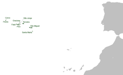
Azores - officially the Autonomous Region of the Azores - an archipelago of nine volcanic islands belonging to Portugal. Located approx. 1500 km from the coast of the Iberian Peninsula, it belongs to the Macaronesia. Three main groups of islands are spread over a distance of 650 km (western group: Flores and Corvo, central group: Faial, Pico, São Jorge, Graciosa and Terceiraeastern group: São Miguel and Santa Maria). The varied terrain with steep rocky shores and crater lakes is a testament to the volcanic origin of the islands. The archipelago is still a seismically active area.
The area of the islands - approx. 2.3 thousand. km² (the largest São Miguel - 759 km²), population - 243 thousand. (2007). Administrative Center: Ponta Delgada. Since 1976, the inhabitants of the island have enjoyed partial and since 1980 even more autonomy.
The islands, known to the Phoenicians in antiquity, were rediscovered in 1427 by the Portuguese who carried out a quick colonization of the previously uninhabited archipelago. An American air and naval base has been located here since the Second World War
Geography
The islands of the archipelago are located approximately 900 nautical miles from Lisbon and over 2,000 from the shores of North America, at 39 ° 43 'north latitude, which gives them a relatively mild climate. The temperature does not exceed 28 ° C in summer and does not drop below 10 ° C in winter. Quite high rainfall and very strong winds, which blow continuously in the Azores from February to November (the so-called Azores Highlands), make the weather very unpredictable. Due to frequent fogs, the airport does not serve passengers many days a year, and residents often joke that the storm that will be announced in the weather forecast for the next day usually comes after a week. The archipelago was formed in the Tertiary as a result of a series of tectonic tremors. The same fault, located at the bottom of the Atlantic Ocean, was also the cause of the 1755 earthquake that devastated Lisbon. There are many volcanoes on the islands; one of them, Pico, is also the highest point in Portugal (2351 m above sea level). The last volcanic eruption took place in 1957, when the eruption of Vulcão dos Capelinhos enlarged the area of Faial Island by approximately 1.5 km². Thanks to the fertile, volcanic soil and the temperate climate, the vegetation of the islands is exceptionally rich. Most of the plants growing in the Azores were brought by settlers, and Gonçalo Velho found in 1427 the islands covered with thickets and low forests. The islands are home to geothermal waters, geysers and inland lakes formed in the craters of extinct volcanoes. An interesting fact is the way of preparing some local dishes, such as cozido - vegetables and meat are baked in hot sulfur springs.
Climate
History
Policy
Economy
Drive
By car
By plane
By ship
Cities
Interesting places
Transport
Shopping
Gastronomy
Accommodation
Security
Health
contact
| This is outline article. For now, it includes the article schema and not much else. You can help by supplementing the article with at least basic information, making it useful. |