
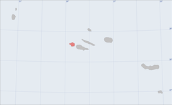
Faial is one of the Azores Islands.
To know
Faial is the westernmost of the central group of Azores. It is located west of thePico island, from which it is separated by a sea channel just 8 km wide. The numerous viewpoints on its eastern side offer beautiful views of the Pico volcano.
The island has a shape vaguely resembling a pentagon. Like all Azores it is of volcanic origin. In its center is located the Caldeira of 2 km in diameter and 400 m. depth. The internal walls of the crater are covered by dense vegetation including numerous hydrangeas that have earned Faial the nickname "Ilha Azul" (Azure island). Between 1957 and 1958 Faial experienced intense volcanic activity which led to the formation of an islet which then joined the mainland with a short isthmus.
The island's capital is Horta, lying on a deep gulf in the south-eastern corner. The gulf is the best natural landing of all Azores. During the Second World War it was the chosen place for the installation of a military base USA. Today the tourist port of Horta is cluttered with private yachts of a certain tonnage that stop there during their crossing of the ocean. They generally sail from the coasts of the Cornwall headed to the island of Barbados, the most eastern of the Caribbean.
Geographical notes
The highest peak is Cabeço Gordo with its almost 1,000 m.
Territories and tourist destinations
Urban centers


- Caldeira - The center of Faial is occupied by a large crater, called "Caldeira". The road from the capital passes through Flamengos, the first village to be founded by European settlers. In its vicinity is the botanical garden. Also interesting is the trip along the "Ribeira dos Flamengos", a stream that crosses a very green valley. The descent into the crater is challenging and generally requires a local guide. Nevertheless, the excursion is interesting because it allows you to observe the laurel forests (Laurisilva) that once covered the whole island. Once you have visited the Caldeira it is possible to descend in the direction of Praia Norte or in the area of Capelo dominated by the lunar landscapes of the coast. The 3 km path known as "covered by Levada" is easily accessible by anyone and is appreciated by ecotourism enthusiasts. An extension of it begins near an artificial lake and penetrates through a tunnel inside a basaltic volcano "Cabeço dos Trinta" and then flows directly into the crater. Another excursion is to "Cabeço Gordo", the highest point of the island (1043 m.) Which offers a panoramic view of the Caldeira.
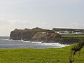
- 1 I get it - Village in the northwest near the site of the 1957-1958 eruptions that transformed the landscape of this corner of Faial. The eruption of "Vulcão dos Capelinhos" lasted a whole year accompanied by continuous earthquakes. On 10 October 1958 the "ilha nova" was formed which in the following days grew in volume until it joined the mainland. Today (year 2012) the volcano is in a quiescent phase, which makes it possible to visit it. Tourists are welcomed in a nearby center where a path leading to the lighthouse begins, located right on the crater's escarpment.
- Castelo Branco - Another traditional village on the south side, next to the airport runway. In its vicinity is the morro of Castelo Branco, an imposing promontory of volcanic origin which was then heavily eroded by marine agents. Today it constitutes a natural reserve to protect the rich birdlife that has chosen it as its home.
- 2 Feteira - Rural village of 2,000 inhabitants on the southern slope dominated by the ruins of a fortress that served as a defense against pirate raids during the 17th century.
- Horta - Island capital, Horta it is the seat of the parliament of the autonomous region of the Azores. A very lively city, Horta has been nicknamed "Capital do Mar" thanks to its harbor full of boats of all kinds. In the past, lone navigators such as Sir made a stop at Horta Francis Chichester ed Éric Tabarly which in 1964 won the "Single-Handed Trans-Atlantic Race". Today, however, the private yachts at anchor in the marina are no longer counted. Its gulf is limited to the south by Monte da Guia, a promontory which takes its name from "Nossa Senhora da Guia" (Our Lady who guides us), patron saint of fishermen in Portugal and figure derived from the Orthodox Church. Until the eighteenth century Monte da Guia and the underlying Gulf of Porto Pim were in fact a center of whaling. More prosaically, Monte da Guia is the point where submarine cables intersect that allow telecommunications between Europe and the Americas.
- 3 Praia do Almoxarife - The beach of Almoxarife extends on the homonymous bay located immediately north of the gulf of Horta and separated from it by the promontory called "Morro da Espalamac". The beach is made of black sand and is home to the only campsite in Faial. Always on its southern limit it extends Poço das Asas, a nature reserve. Poço das Asas is an idyllic place with small waterfalls that form natural pools surrounded by lush greenery. After crossing the park, exit at the viewpoint (Miradouro) of Nossa Senhora da Conceição in the village of the same name, attached to Horta.
- Praia do Norte, Cedros, Salão, Ribeirinha - Four villages on the northern side beaten by impetuous winds and thunderous waves that make bathing impossible. It is no coincidence that the north coast is referred to as costa brava (wild coast). It is a coast with cliffs eroded by the action of the ocean. The road that crosses the villages is however panoramic and winds through contrasting landscapes, now of black lava, now of intense green. In particular the hilly area of Ribeirinha it has very fertile soils and is characterized by orchards that sprout among vast expanses of hydrangea flowers.
Other destinations
- Bay of Porto Pim - Separated from the Gulf of Horta by the promontory of Monte da Guia, the bay welcomes the homonymous beach, very popular due to its proximity to the capital.
- 1 Varadouro - Bay of the eastern side limited to the south by the morro of Castelo Branco and to the north by the Ponta do Varadouro where the beach of the same name is located, one of the few in Faial that allows a swim among the roaring waves of the ocean. The beach is in fact sheltered from the trade winds which instead furiously sweep the north and east coasts. Alternatively, it is possible to bathe in one of the hot springs scattered nearby.

Access tunnel to "Cabeço dos Trinta"

Baía do Porto Pim seen from Monte da Guia
Feteiras

Ponta dos Capelinhos

Praia do Almoxarife

Miradouro de Nossa Senhora da Conceição


How to get
By plane
- 1 Horta airport. SATA Air Açores is the local company that provides connections with the other islands of the archipelago (Crow, Flores, Ponta Delgada, Terceira while Azores Airlines manages flights to / from Lisbon.

How to get around
By public transport
Farias is the name of the local bus lines that connect the various island centers. On Sundays and holidays the races are canceled.
What see
Events and parties
- Semana do Mar. Regatta held in August and accompanied by a food festival, concerts by regional bands and folkloric dances.
What to do
Shopping
How to have fun
.jpg/200px-Peters_Bar_(385591787).jpg)
Night clubs
- Peter Café Sport, Rua José Azevedo 9 - Horta. Local historian inaugurated in 1918 and frequented by lone sea wolves who stopped off at Horta on their Atlantic crossings from the Caribbean to the European coasts. The place is still frequented by Yachtsmen.
Where to eat
Moderate prices
- , Tv. Do Carreiro (Horta). simple meat and fish dishes, toast and hamburgers
Average prices
Where stay
Safety
How to keep in touch
Around


Itineraries
Periplus of Faial
Assuming you leave the capital in the direction of the airport and with the intention of completing the tour of the island (About 100 km) in the sense of the clock hands, we will meet the following places: Baía do Porto Pim, Feteira, Castelo Branco, Varadouro, I get it, Praia do Norte, Cedros, Salão, Ribeirinha is Praia do Almoxarife.
 Poço das Asas |  Panorama of Horta from Monte da Guia |  Monte da Guia |