| Coquihalla Road (Coquihalla Highway (in)) | |
 | |
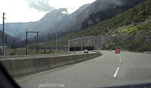
| The Coquihalla Road on the Thompson Plateau | |
| Information | |
| Departure | Hope |
|---|---|
| Stage | Merritt |
| Arrival | Kamloops |
| Length | 303 km |
| Country | |
| Region | British Columbia |
The Coquihalla road (pronounced "coke-a-hal-a"), nicknamed "Rooster", is a main road that connects the region of Greater Vancouver inside the British Columbia. She crosses the magnificent Cascade Mountains.
Understand
The Coquihalla Road is one of the main roads connecting the interior of the British Columbia. It actually corresponds to a portion of Highway 5. It heads north from Hope towards Kamloops Passing by Merritt. It crosses the provincial parks of Monk and Lake Le Jeune before climbing to the top of Coquihalla Pass at 1 240 m altitude and cross the Thompson Plateau.
It is more than a road to get to its destination, it is a destination in itself since it crosses the Cascades chain and features significant environmental changes from the misty cedars and firs of the coast to sun-drenched rock faces in the span of just half an hour. The scenic route is particularly spectacular at the start of autumn, that is, in October, when the fields and the foliage of the forests present a golden glow.
Story

The Coquihalla Road was built in the 1980s with the aim of reducing the traffic density on heavy truck routes and in order to reduce the journey time by a few hours. It was a toll road until 2008.
Steps
To go
Circulate
The speed limit on the Coquihalla Highway south of Merritt is of 120 km / h. The rather steep slopes of the road mean that it is less used for commercial purposes and makes the journey easier, weather permitting. Indeed, difficult weather conditions at the top of the pass can cause road closures from October to May.
The total journey from Vancouver to get to Kelowna via the Coquihalla route takes approximately 4 h.
If you are not a driving enthusiast or if you are not an experienced driver and you are afraid of driving in the mountains, note that it is possible to take a coach from the Greyhound company. So if you are in a group, everyone can enjoy the ride the same.
To see
Do
To buy
Eat
Have a drink / Go out
Security